In brief: We’re happy to have Dwight Silverman, a longtime Houston tech journalist who is working with us behind the scenes, contribute this post on how to find hyper-local forecast information from the powerful computer in your pocket. Dwight explores some features and data in your phone’s weather apps you may not know existed.
Whenever a storm is bearing down on the Houston area, Eric and Matt are swamped with questions about conditions at individual readers’ locations. They have time to answer a few of them, but given what needs to be done and the volume of work they face, they can’t respond to all of these queries.
But there’s good news: Often, the answers you seek can be found in the palm of your hand.
Nearly everyone carries a smartphone, and many weather apps that are included with them can give you a lot more detail than just the current temperature and rain chances. Some let you drill deep into the metrics you want to know most about a major storm – wind speed and precipitation. Want to know what peak wind gusts will be when a storm is forecast to be nearest you? Or how much rain is expected to fall near you? There is, indeed, an app for that. They’re not perfect, and they don’t do a great job with uncertainty in forecasts, but they offer a solid approximation of what to expect.
This post is not intended to be a manual for weather apps, but rather to shed some light on features you may not realize are there, or are hidden a few layers deep in an app’s design. There are many third party weather apps out there, and I am not going to try to cover them all. But I will offer tips for some of the better one, and those that are included on your phone.
Space City Weather
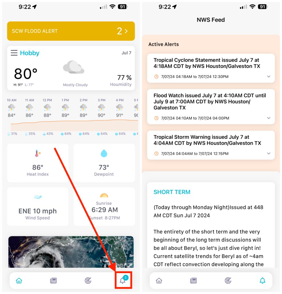
You may have heard that we have our very own, free app? It’s true, and it’s available for both Apple products (iPhones, iPads, Macs) and Android devices. The app is primarily designed to give you quick access to Eric’s and Matt’s posts, current conditions, hourly and daily forecasts for a week out, as well as radar for any of 12 cities in our region. But one thing you may not realize is that it includes detailed, up-to-date National Weather Service forecasts and advisories on storms and hazardous conditions.

Open the SCW app, tap the bell icon in the lower right corner of the screen to get to the Active Alerters as well as short- and long-term advisories. There are also discussions of aviation and marine weather as you scroll down. (Note: The aviation section will NOT tell if your flight has been canceled! Check with your airline, and keep an eye on the FAA’s airport status website.)
Apple Weather
After Apple bought the popular Dark Sky app, it soon redesigned the app that came with iPhones, iPads and Macs to incorporate the former’s hyperlocal forecast features. It will give you details about conditions – both current and future – at relatively precise locations.
However, this integration has been, umm, less than smooth. For example, last year the app was not loading data, and in other instances it was forecasting rain when there was none. The patient seems to have stabilized lately, but it’s a good idea to double-check what you see in Apple’s Weather app with other sources. (You can find where Apple gets its weather data here.)
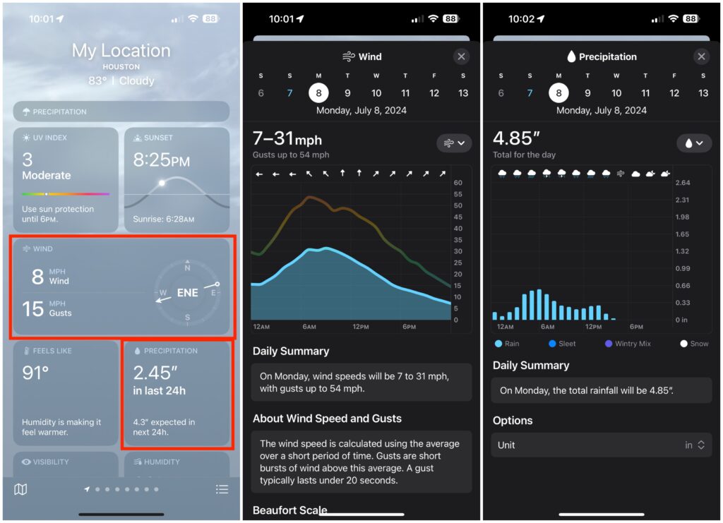
That said, the app makes it easy to see forecasts for specifc conditions, particularly wind and precipitation, at your location. On the iPhone, iPad and Mac, it shows you conditions in individual tiles, and tapping any of them takes you to a screen that lets you move forward in time to check the the forecast for a specific condition.

For example, if you scroll down on the iPhone to the Wind or Precipitation tiles and tap one, you’ll get the current conditions for the day in a chart. Scroll to the left to move to the next day, or tap the calendar date near the top.
Traveling and want conditions and forecasts for a different location? Enter the ZIP code in the search field. You can save any of the locations for future use. You’ll also see forecast alerts, warnings and advisories for those locations.
Android devices
Unlike Apple devices, which all have the same detailed Weather app, Android smartphones and tablets use different apps and services, depending on who makes the hardware. For example, Google’s Pixel phones use Google’s own weather service for much of its onscreen information, while Samsung and OnePlus phones will kick you out to a weather website, typically Weather.com.
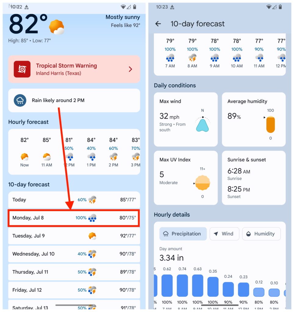
But there is a general strategy you can use: In the five- or seven-day forecast list, choose the day you want to explore and tap it, then look for the metric – wind or precipitation – for the target location.

In the image above, tapping on the weather widget that’s the default on a Pixel phone’s home screen, you’re taken to a general weather page. From there, tap the day for which you want details, and scroll down for wind and precipitation forecasts for that day.
Experiment with the app on your Android phone to find the best route to the information you need.
Next, let’s look at a couple of third-party apps that, while not free for all features, may be well worth buying if you live on the Texas Gulf Coast.
RadarScope
RadarScope is one of the best apps for looking at weather radar data that’s available. It’s a favorite of Eric, Matt and mine, and while there’s a limited-capability free tier, it’s worth the $9.99 annual subscription for the Pro 1 level. (There’s a Pro 2 tier, but most folks will only need Pro 1.) It’s available for Apple devices – and when you pay for it once, you can use it on all Apple products, including the Apple TV 4K streaming box. It’s also available for Android devices, as well as Windows-based PCs.
This is indeed a professional-grade app, giving you access to different kinds of radar technologies and views. Once you unlock one of the Pro tiers, you’ll be able to see the direction storm cells are heading, the location of lightning strikes and local storm and damage reports from the NWS’s crowdsourcing MPing app.

You can pick and choose specific radar stations, both in the United States and abroad, including 13 in Texas. It’s easier to use and navigate on a traditional PC, but still extremely useful on your phone. The help files in the desktop version are helpful, and there’s even a Facebook group you can join to learn from other users.
Windy
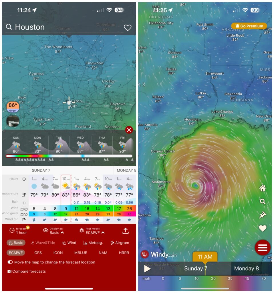
Windy is available as a website and an iOS/iPadOS and Android app. As the name implies, its initial focus is on wind conditions, but it’s really a full-featured weather app, with one very interesting features: You can track storms based on computer weather models. Choose the model you want, along with the date and time for a forecast, and it animates the storm on a beautifully rendered map.

From the home screen, press and hold the Home icon. Tap the Basic label at the bottom to see the various forecasting models that are available. Choose one to see the storm at the current location, then scroll through the timeline to see where the storm is expected to be based on that model’s forecast.
While most of Windy’s features are available for free, some – like a 15-day forecast – require a subscription, starting at $2.99 a month up to $29.99 a year. But most folks can get along just fine with the free version.
There are many, many other weather apps and websites that can help you keep track of storm developments, and as I said at the outset this is not meant to be an exhaustive list of resources. (I didn’t even mention one of my favorites, Merry Sky, which was developed for those who miss the look and feel of the old Dark Sky app. Oh, wait, I just did!) If there’s an app you like, feel free to let others know in the comments.

Great post Dwight!
Thank you!
I’m a “Weather Underground” fan myself!
Same here for Wunderground !
3rd for “Weather Underground”
When does the weather band station start broadcasting? And which station?
Does anyone put out a expected storm surge for main locations, Galveston, Kemah, Baytown, Sargent?? Does storm surge keep coming after winds have died off???
National Hurricane Center puts out maps, but it doesn’t seem super granular.
https://www.nhc.noaa.gov/refresh/graphics_at2+shtml/151128.shtml?peakSurge#contents
Question: Since hurricanes use very warm Gulf water for their life, will the passing of the hurricane reduce the water temperature in the Gulf to any “degree?”
They’ve previously said it decreases the temperature by a small amount for a short period of time (up to 2-3 weeks).
I just gotta say… Apple Weather still sucks. Temp forecasts are way off, it’ll tell you it’s raining when it’s not… Yeah. Don’t trust it.
It was raining somewhere….
Several years ago between my house and the freeway, I went in and out of rain three times in the same zip code!
Storm Radar, useful free radar
https://apps.apple.com/us/app/storm-radar-weather-tracker/id1216396545
In addition the Space City Weather App, Zoom Earth App is really helpful…has radar, wind, temperature (actual and feels like). WUnderground has estimated daily precipitation levels per location on their 10-day forcast and it breaks the wind/precip/temp/etc. by hour.
Thumbs up on Wunderground.
RadarScope is my ride or die
Great list, thanks!
For tropical weather, it’s hard to beat the National Hurricane Center Data app.
I love the Windy App. !!
The link to Merry Sky is taking me to the Windy app in iOS
Fixed! Thanks for the heads up!
I’m confused. The wind shows 95mph for hurricane Beryl when it lands, and I’m in Fort Bend, but the daily max wind only indicates 36mph.
Wow! Very nice. Did not realize the depth of the SCW app. Many thanks for the info.
Thanks for all you guys do! It is appreciated more than you know! Keep safe guys
Why doesn’t SCW app include Cypress as a location?
Great information! Many thanks!
small bug report: you have a broken link for the Windy website link (pesky semicolon)
Glad to see you contributing here, Dwight!
Thank you for all that you do!
What’s your assessment of Carrot Waher?
I meant Carrot Weather
WINDY is an amazing app and very useful for boaters, fishing, surfing, etc. My go to along with Windfinder app
Agreed, best app even the free version is amazing
It looks like the FREE version of RadarScope is no longer available for iPhone. Only the $9.99/year version.
My go-to is Weather Underground (wunderground.com). It’s highly configurable and accurate.
It’s also FREE. Offers all the same features as those $$$$ apps, but doesn’t cost a cent.
I use 2-3 others, but Wunderground is the first stop for me. Laptop, desktop, or mobile device.
Sorry, I’m not paying.
How do I tell WHICH temperature is most accurate for my specific neighborhood? Knowing the temperature at the airport does me no good, since that’s an hour away. Apple says it’s one temperature outside, Android says it’s another, and Alexa says yet a third. Can’t anyone get it right?
Use Wunderground.com … you can select a local weather station.
No HT for What the Forecast? It’s such a great daily dose of laughter.
I really miss when weather channel had a good app, but, much like their cable channel, went downhill
Thanks Dwight. All excellent apps. I do use RadarScope and Windy quite a bit. I’ve got subscriptions to Weather Bell…Pivotal and PredictWind as well. All great sources of information.
I use SCW and Weatherbug. If I want to see what the wind is doing I go to the EarthWindMap website. Just search earth wind map.
I’ve always loved MyRadar. It is just that. i use it when I want to see the radar immediately without traipsing through a bunch of choices. I have the free version. You can zoom in and out at any level, show lightning strikes if you want, and tap on outlined areas to read warnings and watches from NWS. There is a paid tier, but I’ve never needed it.
What’s UP with cnn reporting that Beryl is going to make landfall near Corpus? They cannot be that inept – it felt like I just fell into a different reality.
CNN is inept at everything it reports.
When I tap the bell icon in the lower right corner of the screen, it ends the app. This is a mistake of the programmers.
Just fyi..
Stuart
I use the Harris County FWS website all the time to see rainfall totals. It has rain gauges from all over the Houston metro area and will show, for example, rainfall over the last 15 min to the last 30 days at any of the gauges. Have the mobile version saved as a shortcut.
https://www.harriscountyfws.org/?view=mobile#main
Interesting, the app has never worked as of 5 minutes ago!!
Thank you, Dwight!
What about Katy?
Great post, but will an app know when to evacuate Katy? I think not.
I have more weather information in my pocket than I realized. Thanks for the great article.
I’m a fan of the AccuWeather app
The Bastardi’s are sorry to hear this, but Joel is probably pleased.