In brief: Unfortunately, we are celebrating Father’s Day by issuing a flood alert for the Houston area. There won’t be any issues today, or likely on Monday. But the period of Tuesday and Wednesday is likely to experience heavy rainfall that could lead to flooding. Some of this flooding, especially for areas south of Interstate 10, could be significant.
We are continuing to track the threat of surging tropical moisture this week, loosely associated with a tropical low over the Southern Gulf of Mexico. While there remain major details to parse, the threat of heavy rainfall in the greater Houston metro area is sufficient to put a Stage 2 flood alert into place for the entire region—including Harris and all surrounding counties.

A Stage 2 flood alert signifies the potential for flash flooding. Events falling into this category may cause significant, widespread street flooding across large swaths of the area, flooding numerous cars. Some limited home flooding is also possible, but this is not widespread during a Stage 2 event.
In terms of expectations for flooding this week, for areas along and north of Interstate 10, a Stage 2 flood is likely to be a worst case scenario. However, for areas south of Interstate 10, and especially coastal counties, we may have to escalate to a Stage 3 flood alert depending on how the forecast evolves over the next few days. We’ll be monitoring this closely.
What to expect this week
We have no concerns about weather conditions today. Skies will be partly to mostly sunny, with high temperatures in the low 90s, and only a few, isolated showers. Conditions will be similar tonight. Showers will become more widespread and numerous on Monday, but again rain totals should be manageable for most.
However, the period from Tuesday morning through Wednesday night will see a surge a tropical moisture, and bring the best rain chances into the region. With this kind of tropical moisture we can see high rainfall rates that quickly backup streets, and flood yards. For any plans you have on Tuesday, Tuesday night, and Wednesday, you’ll need to be weather aware. Rain will remain possible for Thursday onward, but the threat of heaviest rainfall should diminish after Wednesday.
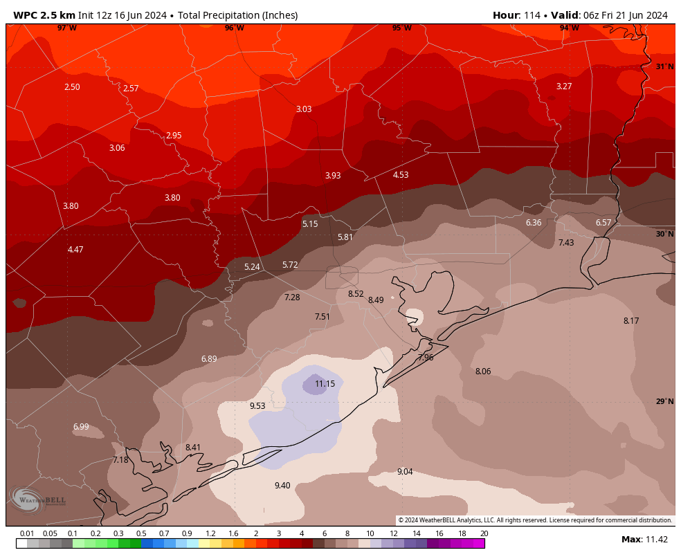
In terms of accumulations, I think most areas north of Interstate 10 will see 2 to 6 inches of rainfall, with higher localized amounts. However for areas south of the freeway, and especially closer to the coast and near Galveston and Matagorda Bays, there is the potential for 6 to 12 inches of rain, with higher bullseyes. Some uncertainty remains. Our forecast modeling remains a bit split as to whether the heaviest rain will fall near Galveston, or further south closer to the Coastal Bend. However, the clear message is that we need to be prepared for the possibility of flooding in Houston. (If you’re wondering about impacts for the entire state of Texas, Matt has you covered on The Eyewall).
In addition to the rains, we’ll see the breeze picking up from the Gulf of Mexico on Tuesday, with onshore winds of 20 to 30 mph, and higher gusts. These winds will be strongest right along the coast. With these winds tides will push a couple of feet higher, potentially flooding low-lying coastal areas such as parts of Bolivar Peninsula.
I do want to be clear that there is a difference between tropical rains and the types of violent wind storms we saw earlier this spring. Straight-line winds and hail are unlikely with this kind of system. The primary threat for most of is going to be heavy rainfall and accompanying flooding.
We’ll have full coverage for you all week.

Any idea on how this might impact flights out of IAH on Tuesday ?
Yep I’m wondering the same.
What kind of effect is this going to have on the reservoirs that are still full from the last rain event?
If you have a glass full of water and you add just 1 drop, what will happen? 2 drops? Many drops?
More rain is not so bad. We were praying for it at this time a year ago.
Tired of all the rains from this drought.
How is it that the rain forecast doubles from one day to the next? The rain forecast has no reliability.
What will tomorrow bring? Will it double again, or perhaps go to zero?
I’m sick of this.
And the current Euro AI models are showing more like 2.5 – 3 inches accumulated for most of Houston by the end of it.
There is no crystal ball. Read the forecast daily, watch for trends, prepare accordingly in the coming days to your comfort level. Weather, like life has few guarantees.
For sure, but I get Scott’s frustration in that SCW usually tries to avoid hyperbole but there is actual data pointing towards a better outcome. Always stay prepared in Houston because things can change at a moment’s notice but if it’s going to be like this with the reports all summer it’s sure going to be a long one.
I really have to say that if anyone doesn’t like a particular site’s forecast, don’t read it.
I don’t understand the scolding some give to the creators of this (free) site.
SCW can’t win with you complainers. People complained about their “no-hype” forecast when the derecho hit. I say if you don’t like it, go get your forecast elsewhere.
I did and the data says the opposite of what SCW is saying. The same models they’re using says the opposite. It’s not about the delivery, it’s about the facts. Don’t like people voicing complaints or concerns then honestly you need to get off the Internet.
You’re complaining about complaining, lol
I know exactly what you mean. But it’s because the actual event is getting closer and models are closing in on it now.
do you have any understanding of weather forecasting or tracking?
You realize it is a forecast, and things change. If you want exact and 100% predictable weather forecasts and get “sick of it” if you don’t get them, then you are going to be “sick of it” all the time.
the models are all over the place, computers arent very good at this
Thanks for the update! Happy Father’s Day !
Better than a drought right now. We will see how the Summer goes…..
29.83 in Cancun at the moment. Winds 131@15kt, gusting to 25(estimated; I have a barometer, but no anemometer.)
Ted Cruz will be interested in this Cancun report. I think he’s about to board his flight to head down there.
Katy comments – Old. Humorous life expired
Ted Cruz comments – Old. Humorous life expired
A drought is better than having your home flooded any day of the week and twice on Sunday. People expressing “need the rain” sentiments have never had a home with three feet of water in it.
Inane comment. Rain brings life, drought kills off everything.
You’re misusing i.e. on your chart for stage 2, you meant e.g.
correct!
I’ll be interested to see which forecast is more accurate, “Our typical physics-based models are focusing things on the entirety of the Texas coast, while our newer AI models favor Houston into Louisiana for the heaviest rainfall.” Physics vs. AI.
I’m not wishing for either a drought or a major rain event, but if you have ever had your home flooded it is clear which one you will pick. Only inane if you have been lucky enough to never have to worry about which option is worse.
I do understand your frustration, no one wants to be flooded but we need rain more than we need drought and neither of us nor anyone can control how much of any kind of weather we get. If the city and county would just stop allowing developers to cover open grass areas with concrete then there would be more land to absorb the rain when it does come. Looking at Houston from above compared to fifty years ago it is very apparent we have a vast more concrete now than we had then and it does not take a genius to understand why we flood more now. Why developers control how the rest of us live or drown is astounding.
Capitalism. Let freedom ring
If it forms into a storm will it become more organized and less or more rain for Houston? There is a H pressure keeping it around for longer? I know there is wind shear I believe in the gulf as well. How do you think tropical formation will affect Houston and surrounding areas?
Isn’t that better — an area that is dryer than Metro Houston?