In brief: Today’s post discusses the rounds of rain (some heavy) that will come to Houston this weekend, likely bringing us much needed relief from an emerging drought. We are also increasingly confident in a fine, fall front next week.
Pattern change ahead
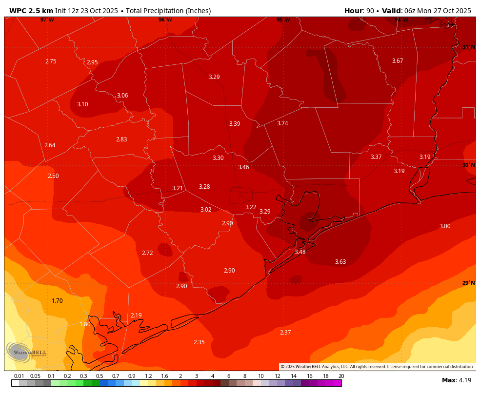
It has been a remarkably dry September and October in Houston, and we’re not talking about booze. Although we have had some weak fronts back door into the region, none have produced enough atmospheric disruption to generate widespread showers and thunderstorms. However, that will change over the course of the coming week. We are going to see an initial front on Saturday that will bring a couple of rounds of storms, but not too much cooling. Then next week, probably in the vicinity of Wednesday, we are going to see a stronger front that seems unlikely to bring much rain, but will bring significant cooling into the area. If you’ve been waiting for rain, or fall, or both, you’re in luck!
Thursday
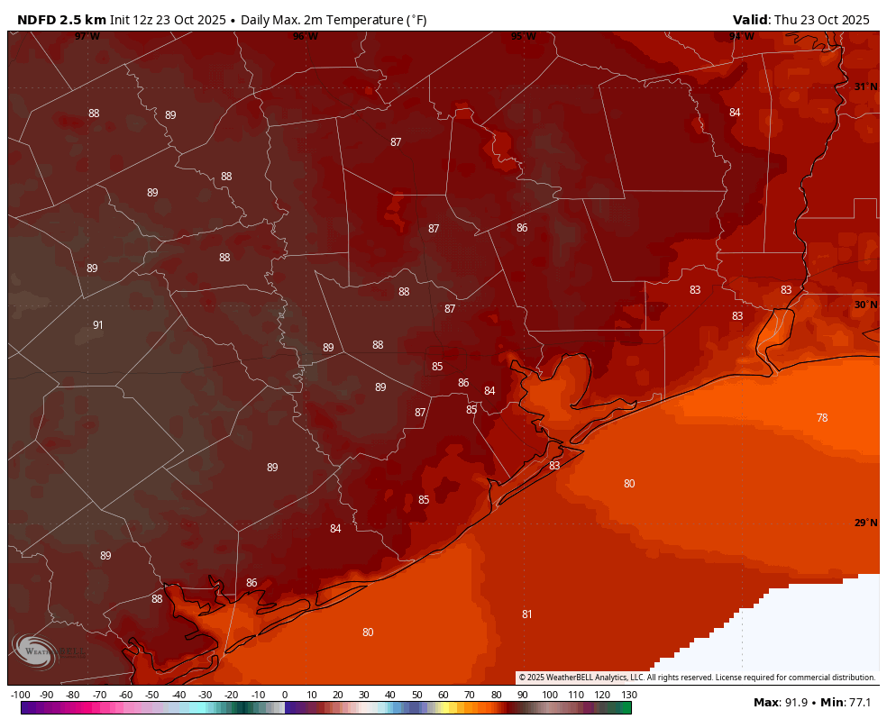
Today will be our last day with near-zero rain chances until next week, although we cannot rule out a few isolated showers this afternoon. Skies will be mostly sunny, but with winds turning more east-southeast, we will see humidity levels rise from what we experienced on Wednesday. Expect highs in the mid- to upper-80s. A few far inland areas may push upward toward 90 degrees, and I’m going to be a little risky here and predict this is our last chance to hit that mark in the year 2025. Lows tonight will be warmer, only falling to around 70 degrees.
Friday
Friday will likely see mostly sunny skies to start, but then with building clouds during the afternoon. Highs will be in the mid-80s with plenty of humidity. Rain chances will increase during the afternoon and evening hours, but overall I still expect this activity to be fairly scattered. So if your plans include Friday Night Lights, the games may well get played. By Friday night we’ll want to keep an eye on conditions to our west. We expect a line of storms to form near the I-35 corridor in Central Texas around midnight, and then advance toward the Houston region overnight.
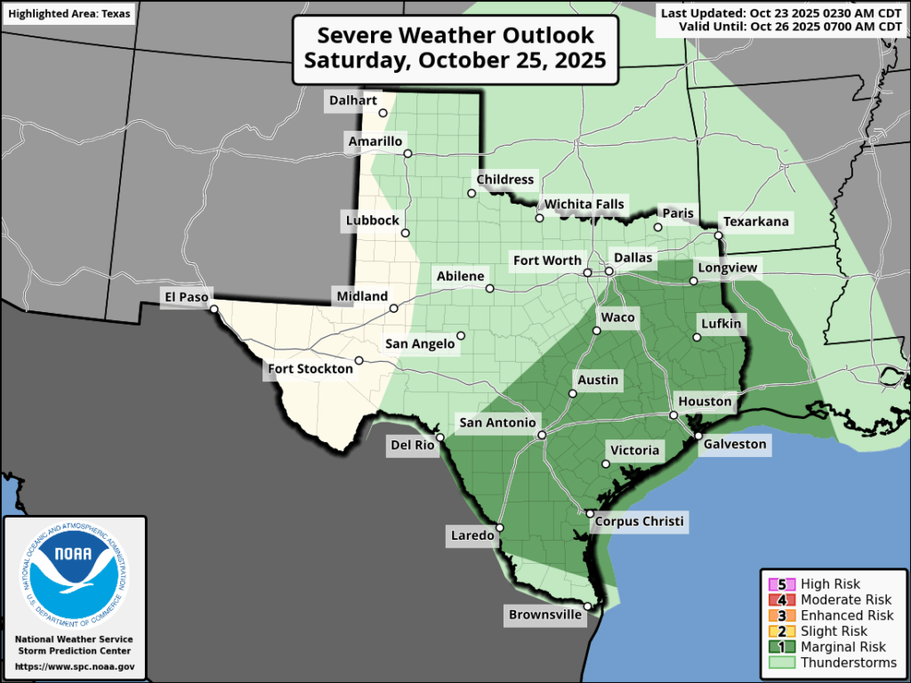
Saturday
The squall line mentioned above will probably—and bear in mind there remains uncertainty in this timing—push through the Houston metro area around dawn, perhaps in the 6 am to 9 am time frame. Some of these storms could be severe, with the threat of hail. But overall severe storms appear to be less of a threat than heavy rainfall. We need the rain, and it could come in bunches. We expect this line to move through and then to (maybe) be followed by a brief lull in activity during the late morning and early afternoon hours.
Careful readers will know we are planning Fall Day festivities from 10 am to Noon in Midtown Park on Saturday. I’ll be back later this morning with a word on our final decision about whether we are going to press ahead. So stay tuned.
Anyway, the front itself should drive another round of showers later on Saturday or Saturday night. All told we think the majority of the region will pick up 2 to 4 inches of rainfall, but higher local amounts will be possible. Since our soils are so dry they should be able to absorb much of this rainfall, so flooding is not a major concern at this time. But we’ll be watching closely. Temperatures on Saturday should be in the 70s for the most part.
Sunday
Rain chances will be lower (but non-zero) on Sunday. Expect highs in the lower 80s with mostly sunny skies in the afternoon. Lows on Sunday night will drop into the 60s, with a bit of drier air.
Next week
The details are still a bit fuzzy, but I think we can expect highs in the low 80s on Monday and Tuesday, followed by a front that will bring drier and cooler air. Anyone ready for lows in the 50s? Because I think that’s coming.
