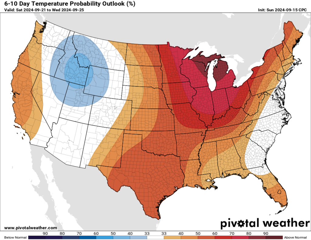
In brief: With high pressure asserting control over our region’s weather, the forecast period looks mostly hot, and mostly sunny, for the foreseeable future. At some point we’re going to start getting some fronts and a more fall-like pattern, but we are not going to reach that point this week.
Highs and lows
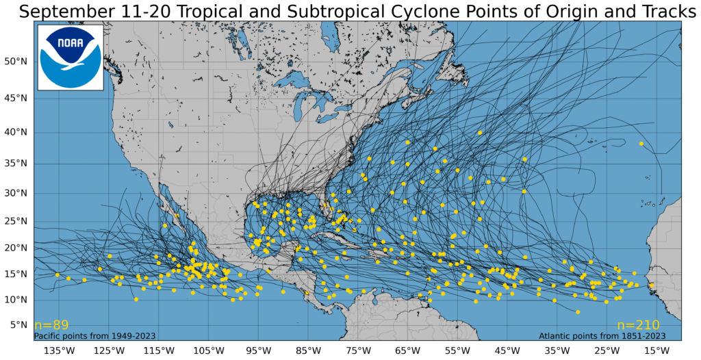
We are now in mid-September, a time when historically the Texas coast is most vulnerable to large and powerful hurricanes. The first line of defense for our region in August and September from hurricanes is high pressure. This makes for hot and sunny conditions over land, but also establishes an atmospheric pattern that steers storms away.

For the next week or 10 days, we’re going to see a fairly dominant high pressure system over the Texas coast. That may not be what you want to see weather wise in Houston, as it will mean hot and sunny days and an absence of fronts to cool us down. However, it will also keep any low-pressure systems at bay. In short, at a time when we would normally be most concerned about hurricanes and Texas, we can breathe easy for now.
Monday
We’ll see a mix of clouds and sunshine this morning before clearing skies this afternoon. Expect high temperatures generally in the mid-90s, with light northerly winds. As for rain chances, they’re not zero, but they’re less than 10 percent. So close enough. Lows tonight will drop into the mid-70s.
Tuesday through Friday
As mentioned above, with high pressure in place do not expect much change in our day to day weather. Highs, generally, will be in the low- to mid-90s with mostly sunny skies. Low temperatures will fall into the mid-70s. Winds all week look to be fairly light, in the vicinity of 5 to 10 mph. In terms of rain chances, they’re not exactly zero. But they’re not much above 10 percent each day. Most parts of our region are unlikely to see any accumulation this week.
Saturday, Sunday, and beyond
At this point the overall pattern appears unlikely to change much this weekend, or even into the early part of next week. Highs, generally, should remain in the low-90s, with mostly sunny skies, and low rain chances through the weekend at least, if not beyond.

Tropic
The tropics are decidedly not quiet, but for our purposes in Texas they’re not of any concern. The only thing I’m watching is the potential for some development in the western Caribbean Sea about eight to 10 days from now. There’s no evidence this will track toward Texas, but it’s the only development likely near the Gulf of Mexico in the near term. If you want to know what’s happening across the Atlantic basin, be sure and check out The Eyewall.

I think I would prefer the mid 90’s to tropical systems threatening the area. The Full Harvest Moon tomorrow will not usher in fall like weather but it won’t be long…
How many more weeks of Summer? We need our version of Groundhog day for the summer.
Historically speaking probably about 3 weeks. Usually between October 6th and 9th is when we get our first real cool front with high in the 70s or 80s with lows in the low 60s and 50s. October 7th is our last 90 degree day on average, although it can and has hit 90 well past that date many times before.
I’ll take heat over a tree through my roof and no power for a week any day.
Agree with no tree through the roof and no power for 10 days for us with Beryl!
Absolutely! Stay with high pressure system!!
Hopefully this heat and beautiful lush green vegetation stays thru Christmas
Oh no! Not a harsh Texas winter where it might get below freezing for like… two whole days. Perish the thought!
How ever will we handle it!
I would say move to Flordia for that, but in recent years we have had unusual heat and humidity extend through most of December. We are also heading into a La Nina Winter this year, which promotes warmer Temperatures in Texas so you may get your wish 👍
I didn’t understand what was the good and bad news. What was it?
Good News = No hurricane threat
Bad News = It’s Hot
Got about a half inch of welcome rain in NE Brazos county last evening. Grass looks greener this morning.
A fortnight after the harvest moon in the ninth month,
a great tempest will rise from the south.
Rain, winds and waves will cross the gulf,
and threaten the land of the single star.
Just stop will you? It’s like you’re whistling for the wind.
Usually, the middle of September marks the effective end of hurricane and himmacane season here in Texas.
IIRC, historically, after 9/24, our chances of getting a hurricane drop to 2%.
Scott the playa. I agree with you sir, short of something developing right off the coast this hurricane season is done.
We had Beryl make things uncomfortable for us and Francine scowled in our direction but in the end left us alone.
Cudda been much worse.
Now a nice cold front to pave the way for the 39 low 60 degree highs we live for would hit the spot.
November’s coming 👍👍
I was gonna argue October has lots of hurricanes but researching it seems October in Texas isn’t so bad. Wow. See article How many hurricanes and tropical storms have made landfall in Texas?
by: Christopher Adams. So I guess it’s Florida that has bad October month. I and my boat are still scared.
No hurricanes is good enough news for me!
I feel strongly both ways. Society, in the end is to blame, both for this story and the chance to read it. If that ther nostredoomas fella were talkin bout us he’d known best to say guf…..gulfs is fer Mexicans n awl wells. Oops hold on ….thought I heard an explosion. Yep, an explosion.thar b morn highs n low pressures to be concerning yersevs wid. This here bloody,floody,blowey,explody,vainglorious meridian will snuff you sooner or later. Squish and squash you……. One waytother. You want it by hurricane? Twister? Derecho? Pipeline explosion? Yer Lawdy,lawds big recall . Well then Come and friggin take it…..and rite soon. ( start one door over, and one street down if an no one answer,kick it down ask for The Guvnuh and the righteous Danny boy Patrick ( the idiot) if thar starts the line, we b fine. ) ……does this qualify as a reply?
Based on the tracks it seems unlikely a hurricane that hits Florida down to Key West will then also go straight west and hit Texas, and instead a curve is common. Its the Cuba to Yucatan storms to fear, right? I guess the storms that cross the thicker part of Yucatan will tend to be weaker after, so it’s the grazing Yucatan storms to fear more??? I also think modern prediction has proven good out to 48 hours, after this the storm track doesn’t change much, so at 48 hours either relax or panic!! D
From what I have heard and read over the years,, an Atlantic tropical system passing south of Cuba through the Carribean typically bears watching for a potential Texas landfall. Obviously there will be other factors at play which determine the track a storm takes, so it’s not a 100% guarantee it hits anywhere in Texas.
All people living within 50 miles of coast including Houston should prepare a bit or they can’t fairly complain. Buy a Jackery power bank and a 12v camping fan , and a cooler to pre-storm pack with ice. For $300 this buys a half week of comfort. Sigh. In the 1990s we didn’t have these options just unreliable smelly generators. And cell phones one can load with books, music, games, and movies are available and cheap now too, and literally take 100 watts to re-charge, which is amazing if you think about the 10 hours of fun that buys. . . . I think we need the Governor to say “Effing prepare for storms and stop complaining so much”.
Soo.. the high pressure will back off right when the system develops in the Caribbean? Not good…