In brief: Wildfire risk increases across Texas today and tomorrow as a dry, windy storm system impacts the state. After gusty winds and some fire risk locally on Saturday, things settle down for a few days. We discuss drought, heat, and what’s ahead today.
Big, hot, dry Texas
Houston officially hit 90 degrees yesterday for the first time in 2025. This is our earliest first 90 degree day since 1996, when we did it on February 22nd and the 5th earliest first 90 degree day on record. So yes, it’s quite early for this. The date of our first 90 degree day has been slowly moving forward over the years. It used to typically be in early to mid-May through the late 20th century, and now it’s usually in late April.

With the exception of the Matagorda Bay region, most of Greater Houston is not currently in drought this March. However, much of Texas is in drought, with that percentage hovering just above half the state. Areas of extreme and exceptional drought are expanding thanks to a year that has brought most of Texas below average rainfall, in some cases far, far below average.
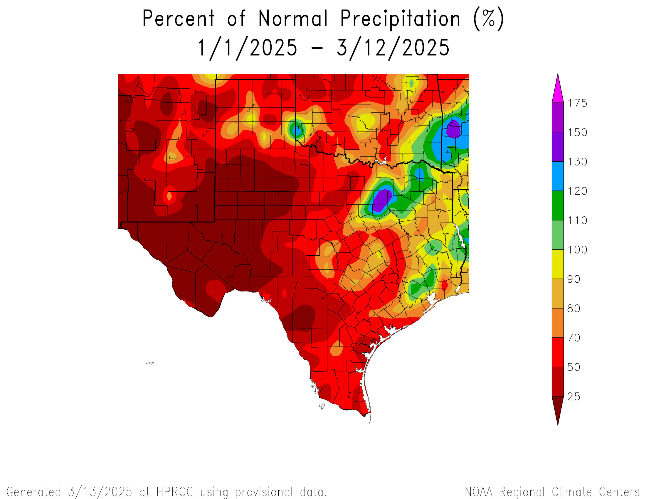
Lately, we’ve begun seeing Plains storms with minimal moisture in Texas and strong winds. This combination continues to dry out soils across the state, which will lead to more drought and periodic potential dust storms across the state as well. It is also allowing for a ramp up in high wildfire risk days.
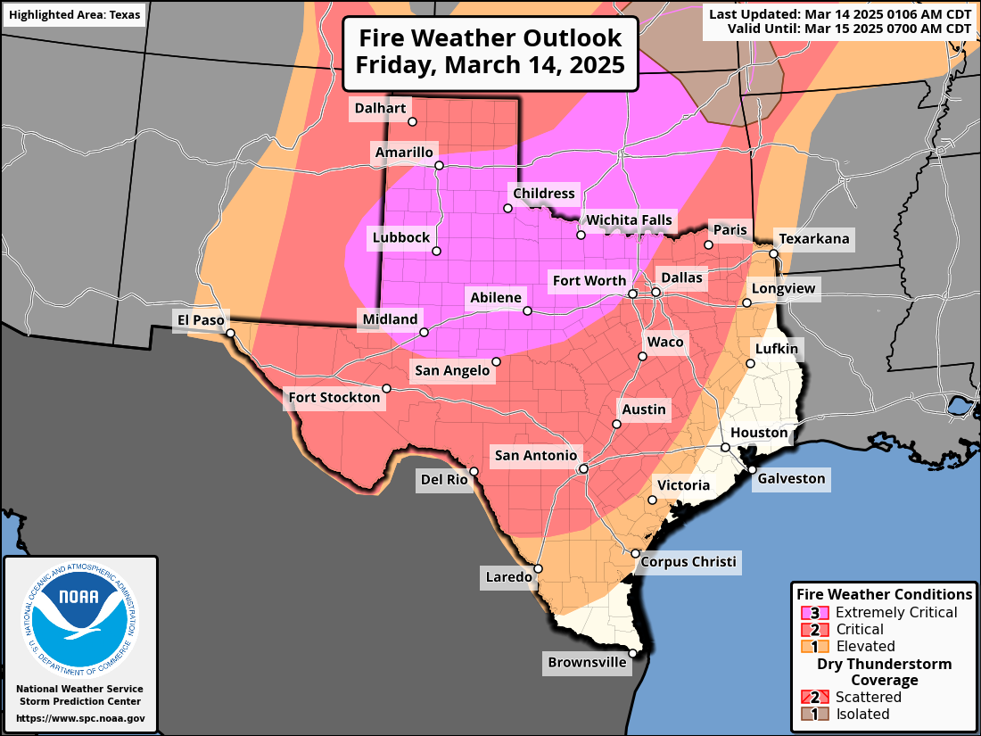
While we don’t need to worry much about wildfires in Houston proper right now because of our relative abundance of moisture this year compared to the rest of Texas, it is possible, if not likely that we will continue to see relatively frequent wildfire risk across the state and up into Oklahoma in the weeks ahead.
We can predict that your next question will be “what does this mean for summer?” And the answer is that it’s too soon to connect what we are seeing now with summer, or at least too soon to connect them closely. Could this mean a hotter and drier summer than usual? Maybe. But it’s not anything I’d be going to Vegas and betting on just yet. For the rest of spring, however, this drying and warming trend is a bit troubling for those hoping we could avoid drought expansion. Something to continue watching.
Today
While the wildfire risk is extreme to our west, here in Houston it will be breezy and at least a little humid today. Wildfire risk begins to ramp up as you go into and west of College Station where Red Flag Warnings begin. The risk is highest in Hill Country, the Permian, Caprock, Panhandle, and North Texas into Oklahoma. We should see decreasing clouds today with temperatures popping back into the mid-80s, if not upper-80s in spots.

If you’re headed to see Journey tonight at the Houston Livestock Show & Rodeo, you’re in luck, as the weather will embrace you with open arms. Temperatures will ease back into and through the 70s, leading to a comfortable exit in the evening. Breezy conditions on Friday afternoon should settle down after sunset. No rain is expected.
Saturday
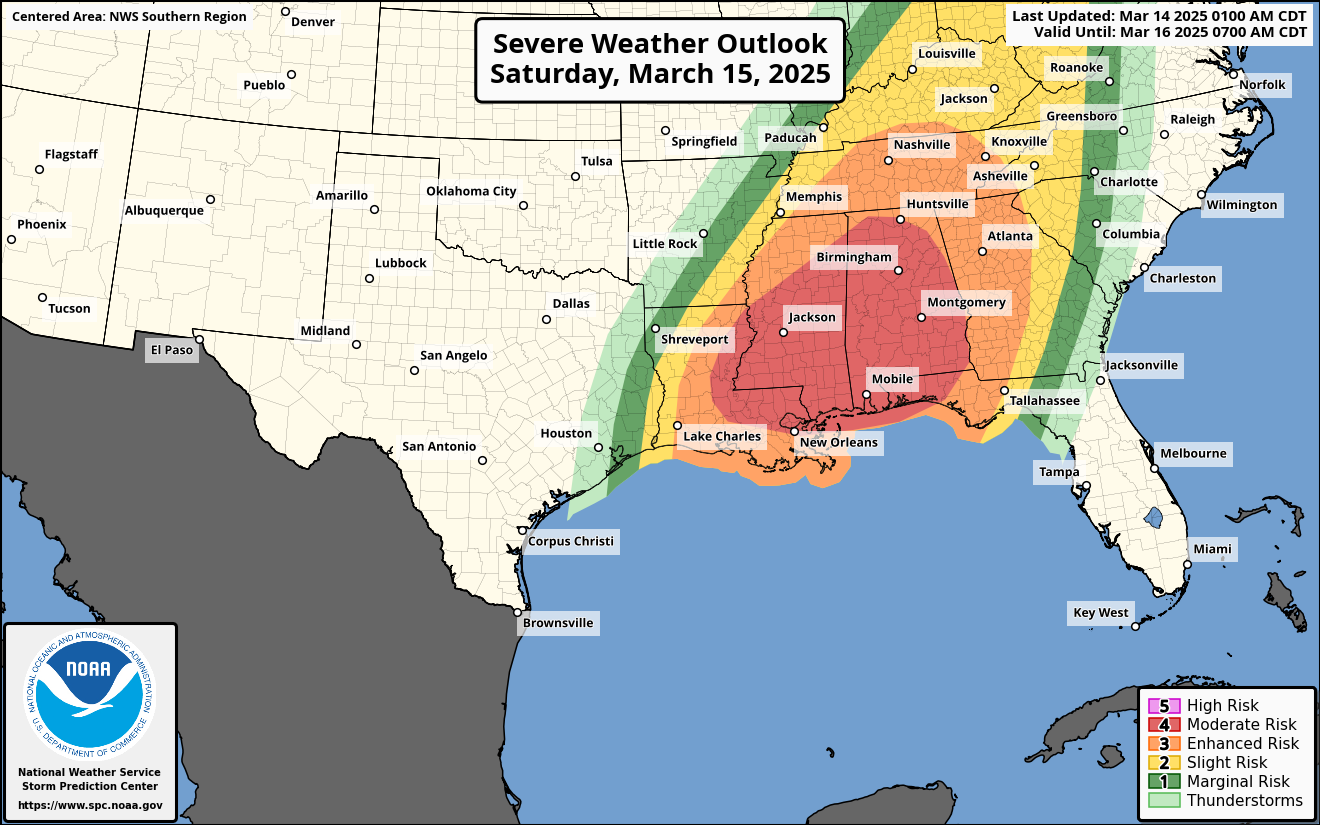
The cold front gets here around or just after sunrise on Saturday. I don’t want to entirely rule out a passing downpour or thunderstorm, but that currently looks to stay well to our north and east. Any rain or storms would be quick before exiting. We should then open up to sunshine after some lingering clouds. Severe weather risks on Saturday are quite significant to our east in eastern Louisiana and Mississippi, so if you’re returning from the eastern Gulf Coast as spring break ends, just keep that in mind on Saturday afternoon.
Winds will begin gusting around midday Saturday, not too dissimilar to what we saw early last week, with gusts perhaps as high as 40 or 45 mph possible by Saturday afternoon. Those winds will die off after sunset. In addition to the gusty winds, humidity levels will plummet, with dewpoints possibly dropping into the teens. It will be desert-like air with highs around 80 degrees.
Wildfire risk may be a bit higher closer to Houston on Saturday due to the winds and low humidity. While our soil moisture is in better shape than it is to our west, that fire risk is definitely not zero on Saturday afternoon and the aforementioned combination of wind and humidity may lead to a Red Flag Warning perhaps up to I-45. Conditions will improve after sunset.
Sunday and Monday
The rest of the weekend into Monday looks great. There should be ample sunshine and a bit less wind with highs in the 70s and lows generally in the 50s.
Rest of next week
Expect a warm up back into the 80s for the middle of next week ahead of a storm system in the Wednesday or Thursday timeframe. This one looks a bit weaker and farther north than this weekend’s system, so while we may turn breezy and have a chance of a shower or storm, the weather from that storm will probably be a little less crazy across Texas and the South. Still, we may need to discuss wildfire risk in parts of Texas next week yet again.

“When spring came, even the false spring, there were no problems except where to be happiest.” -Ernest Hemingway
Today, I am not going to let any quotes about the summer heat or climate change ruin the magic of this spring. It’s nice outside, enjoy it!
This should be no suprise to anyone at this point. With the rapid warming of the planet, we will continue to experience earlier 90-degree days. It will get to the point where we will have 90-degree days every month of the year. June has already gotten like August used to be. I don’t even want to think about how bad this summer is going to be. It will probably blow 2011 and 2023 out of the water. We are already fixing to be in a severe drought, and the 4 month death ridge hasn’t even set in yet.
Yeah. Starting to feel Permian around here already.
But, looking at the positive spin, maybe a death ridge would deflect the RI hurricanes already pre-brewing in the Gulf.
☠Ridge = 🌬🌀Away
You know, gotta look at the bright side 👈🏻
This the 1920s and 30s over again!!!
Dude, where is the sun (and I am not directing this at anyone in particular, just annoyed with the continuation of my SAD)?
Well, it’s now 2.30pm here in Magnolia and the sun is beaming. Yea, on occasion, it goes to a haze, but I’d say sunshine is 70+%
I just checked the MSN weather website, tapped on Map, then selected “Clouds” and yea, it shows a line of cloudiness across the center of Houston, in a southwest to northeast angle, clouds on the east side of that angle.
The earth’s magnetic pole is starting to flip (just like it has in the past) and that is going to change the timing of the seasons.
How does magnetism affect sun angle and weather systems? Does this mean summer will start early and end late?
Uh, WTF? That’s absolutely nonsensical. The earth’s magnetic poles have NOTHING to do with the earth’s rotational poles, and seasons are wholly created by earth’s axial tilt.
Given that Houston has been growing continually over the past decades – increasing in sprawl of concrete and asphalt (which preferentially soak up daytime heat) relative to grass and trees (which appreciably don’t in comparison) – shouldn’t we calibrate our review of the temperature history by correcting temperatures to some control point in a nearby natural area that has remained relatively unchanged over the past decades? Otherwise, we say we’re comparing apples to apples, but we’re really not.
Meteorologists acknowledge the urban heat island (UHI) effect and incorporate it into temperature predictions (they should be !), especially for urban areas, as it can significantly impact local temperatures.
However, if you want to use an area that is “in a nearby natural area”, and not the concrete jungle, then the stats will be skewed.
Temperature history for Houston should be in Houston, not in a “rural” section. HOWEVER, isn’t the Temp history recorded at the two airports??
I happened to be watching the local weather yesterday evening and noticed that all of the surrounding temperatures were 88 or less. Only Bush Int hit 90. Would not have been a record if our recording station were moved away from that concrete jungle.
88 is still much warmer than it should be in mid March.
Temperatures on average are warming in rural areas as well. Areas along the immediate coast have been experiencing much warmer summer nights in recent years due to the warming Gulf of Mexico. The polar ice caps are melting at an alarming rate due to warmer air and ocean temperatures. It is not just urban areas that are warming. There is overwhelming evidence that Earth is warming and it is most definitely leading to more unusual warm spells like the one we are in right now.
The one thing for certain is : Summer will be awful here. Just a matter of for what reasons.