In brief: Today’s post looks back at October, and explains why the weather has felt so incredibly hot in Houston this month. We also look ahead to the return of rain chances this week after a very long dry spell. And finally, we preview the arrival of substantially cooler weather during the latter half of next week.
Putting October’s record heat into context
You may have noticed that this October has felt hotter than normal, and you’re not wrong. A majority of days so far, 18, have reached a high temperature of 90 degrees or above. We have set daily highs on five days so far this month, including two extremely warm days (99 and 98 degrees) in the middle of the month before a front rolled through.
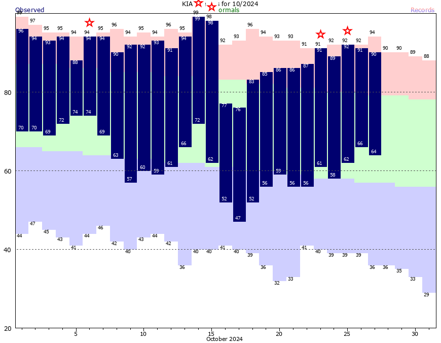
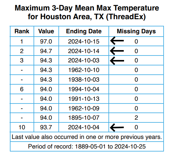
One way to assess the impact of heat is to look at three-day stretches. That is, if we take a three-day period in October, how does it rank among hottest three-day periods in October history? Well, in this case, four of the ten hottest three-day periods in October occurred during this month. The three days in the middle of the month produced absolutely unprecedented heat for this time of year.
So what caused this heat? One cannot escape the background signal of climate change when we’re setting daily high temperatures like this. But if we dig a little deeper there is more at play here. Let’s start with daily high temperatures: the average so far this month is 90.2 degrees, which is on pace to smash the previous record of 86.5 degrees set in 2016. So our days, at least during the 135 years of records we can refer to, have never been hotter. However, our average low temperature this month has been 62.5 degrees. This ranks 42nd all time. That is very far from abnormal. (Note these numbers are not final, but will not change too much before the end of the month.)
What we can derive from this data is that Houston, generally, has had a drier flow this month with a lot of easterly breezes. This has kept dewpoints down bit. Therefore we have had hot and sunny days, with cooler clear nights. Based on average temperature, this month will still end up among the five warmest Octobers of all time—the daytime highs have been that extreme—but comparatively speaking our nights have been relatively mild.
Monday
I write all of that to say the humidity is coming back this week, and you’re going to notice the southerly flow. Winds today will be from the southeast, with gusts up to 20 mph. We’ll see mostly sunny skies, with highs in the upper 80s. Low temperatures tonight will only fall into the lower 70s, so it will be very muggy outside.
Tuesday
Conditions will be similar to Monday, in terms of warmth and mostly sunny skies. The only difference is that our southeasterly winds will increase, and we may see some gusts up to 30 mph during the afternoon hours. So it’s really going to be blowing and going. Lows on Tuesday night may only fall into the mid-70s.
Wednesday
Expect partly to mostly sunny skies on Wednesday, with highs in the mid- to upper-80s. Some scattered rain chances return, especially for the coast, during the afternoon hours. Overall accumulations look fairly slight. Lows on Wednesday night will drop into the low 70s.
Halloween
It has not rained in 70 bajillion years in Houston, and of course the first day with really health rain chances comes on an outdoor holiday. Look, I’m not complaining about the rain, since we desperately need it. But on Halloween? Anyway, the good news is that while most of the region should see some light showers on Thursday, they’re likely to fading by around sunset, when trick-or-treating begins. The daytime showers will be driven by a very weak front that should help knock high temperatures into the lower 80s. Nighttime lows remain very warm.
Friday, Saturday, and Sunday
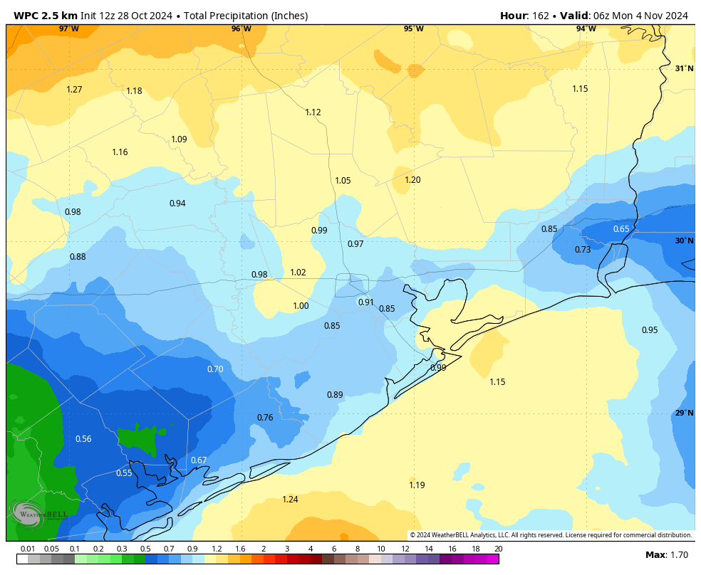
Highs over this period will range from about 80 to 85 degrees for the metro area, with a mix of sunshine and clouds. Each say will see a modest chance of rain, perhaps on the order of 30 to 40 percent. Nights remain warm and muggy. It’s worth noting that although the region will see some welcome rain chances this week, overall accumulations will likely be 1 inch or less for most locations. That is nice, but unlikely to bust our drought.
Next week
The first part of next week should see continued warm and muggy weather, with some modest rain chances. However, there is a very strong signal that by Wednesday or Thursday we’re going to see a fairly robust cold front that should knock our temperatures back to seasonal levels, with lows in the 50s or so. This is far enough out to retain a bit of skepticism, but it does seem pretty clear that we are going to see a significant pattern change some time next week.

Please rain any day any time !
Wish our summers had nighrs like these like they (sort of) used to.
I’m not sure we ever had nights in the 60s regularly during the summer, atleast where I live along the coast. But we definitely used to drop into the mud to lower 70s on average during most summer nights. Over the past decade we have been getting much more nights in the upper 70s with an increasing frequency of lows failing to drop below 80 degrees.
More concrete equals more heat overnight.
There isn’t concrete 50 miles outside of the city in the middle of the wilderness where day and night temperatures have also been averaging much warmer on a longterm scale.
October is the new September.
Yep, basically tack on another summer month to the tally now.
I think this October was a mix of climate change and natural variability. Next October may be the exact opposite. We could be stuck in a rainy cooler pattern next October like we were in 2018. It depends strongly on the Arctic Oscillation, ESNO, and some other factors that influence the jet stream.
The effects of climate change are possibly slowing the jet stream movements down, which keeps these blocking upper level highs over certain regions for longer periods of time. This can exacerbate hot and dry spells by making them last longer, which can make it easier to break record highs.
I think most of the warming over the last forty years or so can be attributed to the urban heat island effect. This is pretty evident in the comparison between Houston and Galveston temperatures. IAH which has grown exponentially over recent decades is currently running about 3.8 degrees above normal. Galveston which has much less concrete and is surrounded by water is only 2 degrees above normal.
The urban heat island effect is causing warming inside big cities, but rural areas are also warming up more and more over the years. Warmer ocean temperatures are also adding to the issue like warmer nights and higher dew points. This intensifies the heat index making the heat more dangerous for outdoor workers.
Apologies in advance fit my pre-coffee dumb Q, but the headline made me think we’d have more of a deep-dive explanation of the late-season heat (and drought) than easterly flow and drumbeat of climate change (which I don’t argue so let’s not start a thread on that, please). Is there something else specific locking us into this heat?! A dry pressure ridge or change in jet stream or La Nina or…? In other words, is this just likely to be our new October normal vs. an anomaly?
A dry surface high, an upper level blocking high. And a positive Arctic Oscillation are the most likely cause of the pattern we have been stuck in this October. I am confident that this is not a new normal for October. We can experience sharp variations in October. Next October will likely be a much different scenario. This was likely just an anamoly however, the circumstances that lead to anamolously warm and dry conditions will likely happen more often from here on out.
Bring on the rain and the cold weather! Felt the humidity coming back already this morning.
You know it’s bad when you go outside to go to work and you need to use the defrost in your car for the condensation. 🙁
Or you see fog in the morning and it’s 70 degrees outside.
That too. Blechhhhh.
I went to the game this past Saturday in College Station (Geaux Tigers….still) and it was, I think, the hottest I have ever been. I had heat exhaustion. This late heat is ridiculous.
I feel your pain, I was at a Cardinals – Packers game in late October a few years back before the Cardinals new stadium was built. A 2 PM game and 107 degrees at kickoff. There was not enough beer in Sun Devil Stadium for the overheated Packers fans.
The heat exhaustion was probably a result of us Aggies winning the game 🙂
We’re now on top … I’m just waiting for the Nov 30 game – been too many years.
(brother is a Longhorn grad – imagine that 🙂
.
Anyway – the weather for us on Saturday was fine, plus the last two days. Just waiting for anticipated rain.
I am working Elections. Carrying the voting booth to the person voting curbside has been not fun (heat)
Side Note just for you EB:
Had gentleman standing in line to vote wearing Artemis shirt. He works on instrumentation. Told him I’d been following Eric Berger as he documents the journey of the Project.
“Yeah, Eric writes about us. Alot”.
Lol
Thank you for working the election!
👍
Boy do I get tired of the words ‘Record Heat’. It almost feels like we break records all the time. Maybe things are getting warmer…
I see spacecityweather has finally bent the knee to the climate change narrative. Unbelievable. The whole reason I started reading years ago was because you guys didn’t play into that hype. (I was even referred by an actual meteorologist). But, that was a few years ago, and now, here we are. Maybe if we pay more taxes we can stop climate change, right? Or, if we all buy electric cars and bump the thermostats up to 80? Maybe?
They have been mentioning climate change for really years on the site. It’s not hype if it’s backed by data.
Maybe if we pay more taxes we can stop climate change, right?
All I see is people out all day during work week buying and consuming crap. Damn right we’re gonna tax em! Got money to blow ain’t hurting too bad, tax the hell outta em
Have you tried pulling your head out of your butt? Does constant RECORD HIGH HEAT not mean anything to you or do you think thats fake too? Why are you even here?
Way to miss the forest for the trees
There is nothing that will ever convince these people. When we start having 30 day stretches of 105-110 degree temperatures in July and August, they will just say “it’s summer”. And when we start hitting 90 degrees on Christmas, they will still pretend like nothing is going on.
There is nothing that will ever convince these people. When we start having 30 day stretches of 105-110 degree temperatures in July and August, they will just say “it’s climate change”. And when we start hitting 90 degrees on Christmas, they will still pretend like humans are the problem.
The only problem many humans have in denying we are absolutely responsible for heating up the planet is having a blank mind.
Convince them of what? What other explanation besides climate change could you provide if we actually start having 30 day stretches of high temps above 105 degrees?
I don’t think Eric and Matt have really ever tried to hide their position when it comes to climate change. The science is pretty compelling…
I think they have been pretty level headed in their position and to the best of my knowledge have never advocated for increased taxation, a conversion to EV’s or adjusting the thermostat up in an effort to combat AGW.
“The science is pretty compelling…” … yes, depending on which $cientist$ you ask.
I conducted a site-specific search using Google “site:” search, combing through search results of the archives on this site for the keyword “climate change”, and while there were no instances of “AGW” that i could find, there were an overwhelming number of results for “climate change” in………. the comments.
The authors do talk about “climate change” and while it has been mentioned sparingly by them since about 2016 in their posts, it is plain to see that the talking point appearing in the authors’ posts more frequently and with more bravado in recent years/months as the overall “Climate Change” narrative has become more prominent in mainstream media.
The trend is clear. They’re hopping on the corporate bandwagon, sadly. Google site-specific search for the win.
Of course climate change is real. The planet has gone through many warming and cooling phases throughout its existence.
Maybe if we pay more taxes, we can stop it!
(get ready for the “comments are closed” message any minute now)
Lol at $cienti$t, like any C-suite oil executive is starving out there with zero interest in maintaining business as usual…
They have been really clear. You don’t have to follow them if you don’t like them mentioning the obvious and choose to believe human can control micro weather events (talking about directing hurricanes) rather than influencing long-therm climate trends.
So which corporate will benefit the most if everybody in the US is forced to switch to electric cars? And which side is the boss of that corporate supporting right now? (Hint: it can’t be more obvious)
Why are you so upset that they are mentioning what they observe? These guys look at their data trend, which they also show us snapshots of. They are experts in the field of meteorology and are merely reporting the trends they are seeing.
You can lead a horse to water, but you can’t make it drink.
I agree with Glenn. It is getting warmer. We have the measuring instruments now beyond local thermometers to asses that the world is around 2 degf warmer on average since 1980. Mostly felt at night. I think SCW handles the topic very well.
It is inevitable CO2 emissions will be eliminated, within our generation or the next, with commercial technology. The big oils are not against all this …they’ll be glad to make and transport green hydrogen, ammonia when that is technically feasible. A lot easier than drilling and refining oil.
“..the good news is that while most of the region should see some light showers on Thursday, they’re likely to fading by around sunset”
How on earth can that be considered ‘good news’ when Houston is in a major drought? The bayou trail yesterday had an arid smell about it and the landscape was parched, I doubt the vegetation would give a damn about kids getting wet on Halloween. We really need to get our perspective in order.
“Most of the region should see some light showers on Thursday, but they’re likely to fading by around sunset, when trick-or-treating begins. This is fortuitous timing for the many people who choose to participate in outdoor activities Halloween night.”
There, I fixed it for you, Ken. Happier?
I’ve seen toads; fat, sweaty, crawly things that snuffle around in boggy places, is that you?
caught perpetuating negative stereotypes about toads LOL
Actually toads are some of the best animals for home gardens.
I think I understand where you are coming from, and I think you are wrong. If you think the health of vegetation is of similar importance to the happiness of kids, then you need to get your perspective in order.
I am on your side in protecting the environment, but remember that creation was made at least partly for the sake of human happiness, and that a human being is the only part of nature with an eternal soul.
My question is “When was the last year when we had an “average weather year?”. By this I mean a year when the temperatures and precipitation patterns over the course of the year aligned with what historical averages describe as a “typical weather year in Houston “. Does such a year exist?
There never really has been a “normal” perfect balance with the weather in any given year. Drastic variations occur with temperatures, rainfall, coldspells, heatwaves etc on a yearly basis. Some years we have been pretty close to “average”, but more times than not we are either above or below the average for precipitation and temperatures.
The “normal” or “averages” most meteorologist and scientist’s use is typically the past 30 years of data all averaged together to measure what our average high and low is. However, over the past few decades all of our average temperatures for each month keep going up. That is also globally not just us. Global warming is not an overnight thing. It is a longterm warming trend that slowly progresses over years and decades. It has become much more noticeable over the past decade than ever before.
I’m just hoping for no hard freeze this winter.
Why no mention of the MASSAIVE increase in the amount of moisture (water vapor) in the upper atmosphere circa January 2021? The volcano in the Pacific? Does it ring a bell with anyone? Do better SCW…….
OMG … it’s RAINING out here in Magnolia at 10:08pm !!!! I thought, “what is that noise?” and walked outside … it’s RAINING