In brief: Houston will see more of the same through Monday or so, with temperatures running around 7 to 10 degrees warmer than normal and lots of sunshine. We turn up the humidity after Tuesday with increasing rain chances, though the best rain chances may end up to our north. Halloween evening will be warm with at least some chance of rain.
40 years ago today was Houston’s (official) 4th wettest day on record, with hundreds of flooded homes and 10 inches of rainfall. The culprit was a stalled out cold front and several prior days of rain that had primed and saturated the ground. The current forecast has nothing remotely resembling rain until next week.
Today through Sunday
The next few days should feature more of the same in Houston. Expect plentiful sunshine, generally pleasant mornings in the 60s, and afternoon highs in the upper-80s, about 7 to 10 degrees warmer than normal and not far from records. Each morning could see pockets of dense fog in the area, so just be mindful of that. A reinforcing shot of drier air may help shave off a few more degrees on morning lows tomorrow or Sunday, but that should be the only evidence of it that we notice.
Monday & Tuesday
We begin to slowly transition here to a more humid type pattern. Look for daytime highs to stay in the mid to upper-80s, with nighttime lows in the 60s to low-70s. More sunshine is expected, but I would not entirely rule out an isolated shower on Tuesday.
Rest of next week & Halloween
The forecast becomes pretty straightforward in a generic sense after Tuesday. We will have clouds, sun, high humidity, and a chance of showers developing. Look for much warmer nights and mornings and slightly less hot afternoons. The highest chance of rain will probably be Wednesday or Thursday. Yes, there is a chance of rain on Halloween, but it remains much too early to get specific. We are confident that it will be a warm evening though.
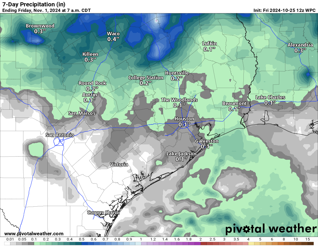
I am a little concerned that the best rain chances will elude us to the north after Wednesday, but we still have time to watch this. Rain totals through Thursday are shown above, as forecast by the NWS. Expect some variability here with some places seeing minimal rain and others seeing perhaps an inch or two.
Next cold front?
There continues to be model evidence of a cool front after next weekend. Exactly how strong and when exactly it arrives remains to be seen. I’d still keep my expectations low, but the signal has remained at least!
Why the struggle to cool off?
Yesterday, Eric noted how the 6 to 10 day outlook showed warm temperatures leading into November. Now, as noted we are hopeful for a cool front somewhere around day 10 or so, but it will be unlikely to deliver actual *cold* air. In order to get true cold here in Texas, it usually either has to come straight outta Canada and down the Plains, your typical ‘norther. Or it has to be manufactured more locally, usually by clouds, rain, and chilly but not necessarily truly cold temperatures. That latter scenario happens to us sometimes in later November through March most often. This time of year, for hints of something beyond just an autumn tease or a setup for more frequent cool fronts, we would probably need to see cold air building up in western Canada.
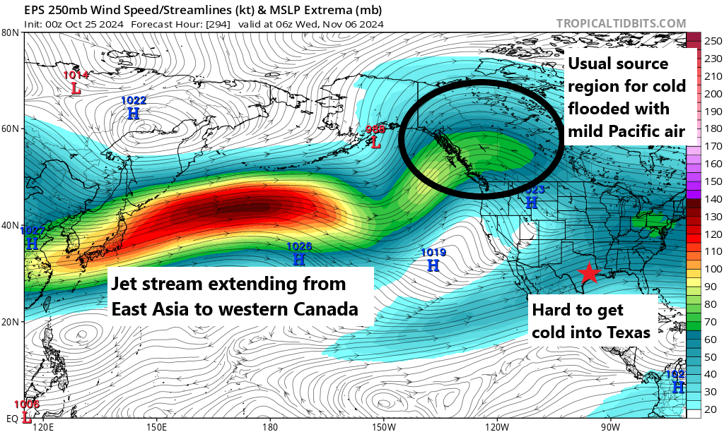
If we look at the Euro ensemble forecast of jet stream winds on the maps above, you’ll notice what is basically a straight shot of green, yellow, orange, and red from China and Japan to southwest Canada. This is the core of the jet stream, and when it is doing this (extending across almost the entirety of the Pacific into Canada), it basically limits how cold it can get up there. It keeps weather active, it ushers in storms, but it never allows any cold to settle. Without that, we kind of have an elevated floor for how cold it can realistically get down here in Texas, as any cold coming out of Canada would be weak to begin with and continue to modify milder as it came southward. This can all change quickly, but there’s absolutely no sign of it right now in any real modeling. Until that gives, expect milder than normal weather to continue more often than not. We’ll still have periodic fronts, but they’ll mostly just reinforce comfortable humidity levels more than anything. Certainly not a bad thing, but it would still be abnormally mild.

Will we see our hottest October on record after next week’s revenge of humidity?
Has to be. 90s this long this late…book it. New record “hottest ever” month.
It’s possible. The record to beat is the October of 2004. The nights were significantly warmer that October because of a dominant Gulf wind that set up over the entire 2nd half of the month. We have had cool nights through most of this October which still may save us from breaking the the 2004 record. However we will likely be in the top 5 or top 3 warmest Octobers on record when this month ends.
Wear your shorts and sandals with confidence this weekend.
More humidity? Just what I wanted in November! 🥴🫠
I hate this Weather! No Fall this year. Ugh…
Agreed. I need to move somewhere cooler with no hurricanes.
Who knew? It turns out pumpkin spice everything doesn’t actually trigger fall to begin.
Wait until you see what months without rain does to our beautiful vegetation.
We have that too! 2022, 2023, and now 2024 have had drought conditions.
I changed my landscaping to Central Texas natives as they are heat, cold, and drought tolerant.
Maybe you should dry Sahara Desert species?
The Sun had reached its Solar Maximum recently. I wonder how the Solar Maximum affects the weather and the climate.
It can slightly increase global temperatures temporarily. It can also manipulate cloud cover and exacerbate storms such as hurricanes. But overall it’s affects are largely unnoticeable by most people.
October of 1984 was a bizarre month in several ways. We had our coolest morning on the 1st in the mid 40s, which is a record I believe. It was also the wettest October on record for areas along Matagorda and Brazoria county. Over 20 inches of rain fell throughout the month. On the 24th a major flood happened in Bay City. My parents were in high School at the time and they let school out early. They said that there was waist high water downtown. Many homes and businesses took in water including my mom’s house. It’s still the worst flood that Bay City has seen to this day.
It’s so fascinating how the weather can sharply vary year to year. For example, we can go all October without a drop of rain, but the next October we can see over 20 inches. December can be very warm one year and then be very cold the next year. It keeps things interesting. It would be boring if the weather had a copy and paste predictions pattern every year. For me, it would take a lot of the fun away if I knew exactly what the weather was going to do all the time.
“..we would probably need to see cold air building up in western Canada.”
A neighbor has family visiting from Ottawa, Canada and they told me this morning that the temperature there is around 29F, is that cold enough?
Ottawa is eastern Canada, so not relevant.
And if it were 29F in BC, that would modify significantly on its way down to Texas if the upper level winds set up to bring that cold down here. Unfortunately the upper level winds are not bringing any air down from up north.
My comment was intended to show the temperature range across the continent, not to particularly expect the current frozen north to have any bearing on what affect it might have on our conditions.
I’ll definitely be leaving town for the holidays. The weather here is constantly hot and gross.
I think I remember the floods of October, 1984. Some of the feeders of the North Freeway were high with water. I was able to navigate my car through it onto Canino Road from the North Freeway feeder. The ditches along the feeder overflowed onto the part of Canino Road near the feeder. I had no problem the rest of the way driving a quarter of mile to work. However, the deep ditches were full on each side of the way and almost covering the roads.
After work, my car would not start. I took off the distributor cap and dried it out. I could not get the distributor cap back on. A mechanic at work helped me out and dried out the distributor area and put the distributor cap on for me. I was able to drive off back home.
Milder temperatures in western Canada probably means more melting of mountain glaciers and Arctic ice, which translates into rising sea levels. The same is happening in the Southern Hemisphere. The geography of the world will look a lot different in the next century.
It’s still freezing mid day in western Canada. The Pacific Ocean on the Canadian west coast is also anomalously cold. Albeit in the 50s. So the reference is to that mild ocean air keeping Canadian air less frigid and the jet staying at the near polar latitudes. It has been here suggested this is due to the positive AO. That is forecasted to flip in Nov. No fast melt going on yet. Order of magnitude is 1 foot sea level in 150 years.
Well, considering the native vegetation is a mix of coastal plain and piney woods, maybe palms and other tropicals shouldn’t have been planted. They suffered an appropriate fate.
I don’t remember the 1984 flood, but I was living in League City and working in Baytown then. Maybe it was elsewhere.