In brief: Today’s post discusses the likelihood of widespread rainfall today and Wednesday ahead of the first of several decently strong cold fronts. Speaking of which, there’s the possibility of a freeze over the next 10 days, so we don’t advise planting tender plants just yet.
Winter is not over yet
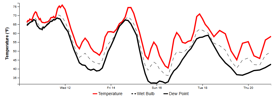
Houston has had an anomalously warm start to February, with an average temperature of 72.1 degrees. This is a shocking 16.2 degrees above normal through the first third of the month. Beginning Wednesday we’re going to enter a cooler, more seasonal pattern. Looking ahead, global models are pointing to the possibility of two stronger cold fronts next week.
The first of these arrives Sunday, and the second possibly by next Thursday or so. One or maybe both of these could drive Houston’s lows into the 30s, and there’s a distinct chance of a light freeze about 10 days from now. I’m not saying it will happen, but it’s definitely possible. So hold off on gardening for a little while longer.
Tuesday
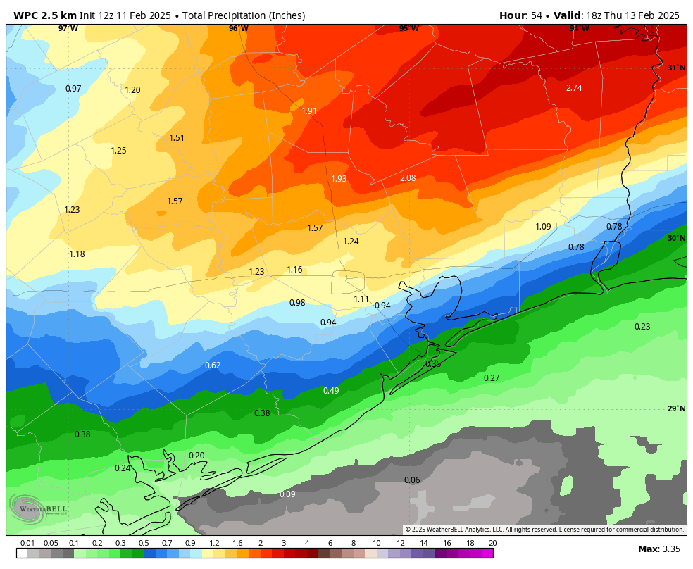
Today is likely to be a fairly wet day. We don’t really have any significant flooding concerns, but streets could pond over amid some of the stronger showers or thunderstorms. The rain will be somewhat scattered this morning before showers become more widespread this afternoon as the atmosphere turns unstable. Showers will likely peak in coverage this afternoon before rain chances diminish somewhat overnight. This won’t be the end of the rain, as we are likely to see another round of showers on Wednesday morning along with the front.
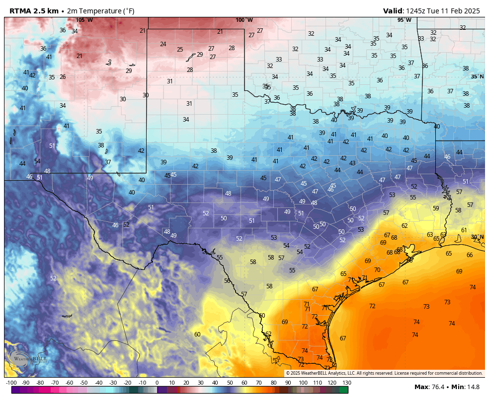
Temperatures this morning are generally in the upper 60s across much of Houston, and they’re going to remain there all day with cloudy skies and the potential for rain. Winds will be gusty, varying from the south, east, and northwest. Lows tonight will only fall into the low- to mid-60s for most locations.
Wednesday
Additional showers are possible on Wednesday morning and into the early afternoon hours, ahead of the actual cool front. Between now and Wednesday afternoon I expect most of Houston to receive 1 to 2 inches of rainfall, although amounts could be a little bit higher for areas well inland, including The Woodlands and points north. Highs on Wednesday will be in the upper 70s for most before drier air moves in during the evening hours. Temperatures will start to fall before midnight, and by early Thursday morning temperatures for most of the area should dip into the upper 40s.
Thursday and Friday
These will be a pair of partly sunny days, with highs in the upper 50s to lower 60s. Thursday will see gusty, northerly winds and Thursday night will be quite chilly, in the low- to mid-40s. Friday night will be a bit warmer, in the 50s, as the flow turns more southerly.
Saturday
A warmer day, with highs in the mid-70s. We’ll again see the potential for some widespread (mostly light?) showers ahead of the next front. Accumulations don’t look overly impressive, but bear in mind the potential for rain if you’re planning outdoor activities. Colder air likely arrives overnight, pushing lows on Sunday morning into the 40s.
Sunday
Sunshine returns for the second half of the weekend, but with a colder, northerly flow high temperatures will likely be in the 50s. Lows on Sunday night could drop into the upper 30s in Houston, give or take. We’ll see.
Next week
Our roller coaster weather rolls on, with highs by the middle of next week likely rebounding into the 70s. However, most of our guidance points toward a fairly strong front for the second half of next week. This is when I think there’s at least a decent chance to see a widespread freeze in Houston.

Too late, plants are already in. Mid 80’s all week what else was I supposed to do.
Just the best you can ⚘
I would appreciate knowing what conditions are needed to have a “freeze”.
Does that mean temps of 32 deg-F and below for some minimum period?
What is the minimum period needed to call it a “freeze”?
And would 32 and below be the temp needed, or does it need to be … say, 31 and below?
Thanks for replies.
The European model is saying 32°F @ 6 PM on the 19th and 23°F @ 6 AM on the 20th, then getting up to 36°F at noon.
32 degrees Fahrenheit is the official freeze temperature. Anything at or below 32 would be considered a freeze. Most tender tropical plants don’t do well if air temperatures drop to 32 or lower for more than 2 hours especially if frost is involved. Temperatures between 32 and 28 are considered a light freeze. A hard freeze is 28 or below for an extended amount of time.
Some tropical plants are a little more hardy and can handle temperatures in the upper 20s for a few hours but once air temperatures drop to 25 or below for 2 hours or more, most tropical plants can’t handle that.
Someone mentioned on here not to begin gardening until the Rodeo leaves town.
Seems to be a good call.
Problem is if you do that, you’ll never get tomatoes here (by the time they get big, it’ll be 105 and humid and they’ll stop fruiting)
I always wait until after Rodeo Parade to plant anything. In general our last really miserable weather catches the Trail Riders about 75% if the time.
Looks like the freeze at end of next week is from a cutoff low from the mid con vs a polar breakout and is of the ~31 deg type. No biggie but we’ll see. I say, let’s retire that rodeo aphorism that people always mention…doesn’t that go thru March? It’ll be very warm by end February.
Weather Bell nailed the cold starting mid February and is predicted to carry over into March. Remember last year when all of the predictions were that winter was over and the heat was coming but we had cool weather all the way to June. The year before as well. Maybe a new trend.
I’m not quite sure where you’re getting that idea from because last spring was much warmer than normal, and we had a heat index value of 116 in late May last year.
Where is the artic cold front that was talked about all last week that was supposed to come sunday night?
Am i missing something? The forecast last week did not have such warm weather for monday-wednesday.
way back 20 years ago or so, the Trail Rides always took place on the week when Valentine’s Day fell, with the Rodeo beginning the following week (and lasting about 10 days). The schedule is different now so in the past that saying was a big more likely.
Ahhh. So 20 years ago that would have the rodeo leaving town end of Feb. So yes it is time to retire that saying – isn’t it. As Eric commented above, if you must try to grow tomatoes here, a normal warm summer climate will be here well before the equinox. This is the gulf after all.
Didn’t show up because of persistent upper level high pressure over Texas and south. I don’t believe we will see any more ‘arctic freezes’ this season. Maybe an ordinary winter cold front mid next week.
Aren’t these storms today supposed to be moderate (not intense?).
I can’t understand why we’ve browned out four times this morning.
Flooding in meyerland currently.
This was literally the warmest first 10 days of February on record for Houston
Does anybody else see a rain signature over the metro at 9:45 AM that’s vastly heavier than forecast?
The forecast appears accurate if you read it carefully. The only thing missing is we are at “marginal risk” which produces the red on radar which gives me and others the willies.
I thought we were getting a cold front sunday night?
I really want some moderate cool weather before Summer. I’m tired of these wild swings – give me some 50 or 60 degree days!!!
Unfortunately, in the world of climate change we live in, there will continue to be less moderation between the extremes. We go from Arctic freezes straight to early May weather in a week. We don’t get 4 solid seasons anymore down here. It’s either winter or summer, with maybe a fair week in between the 2.