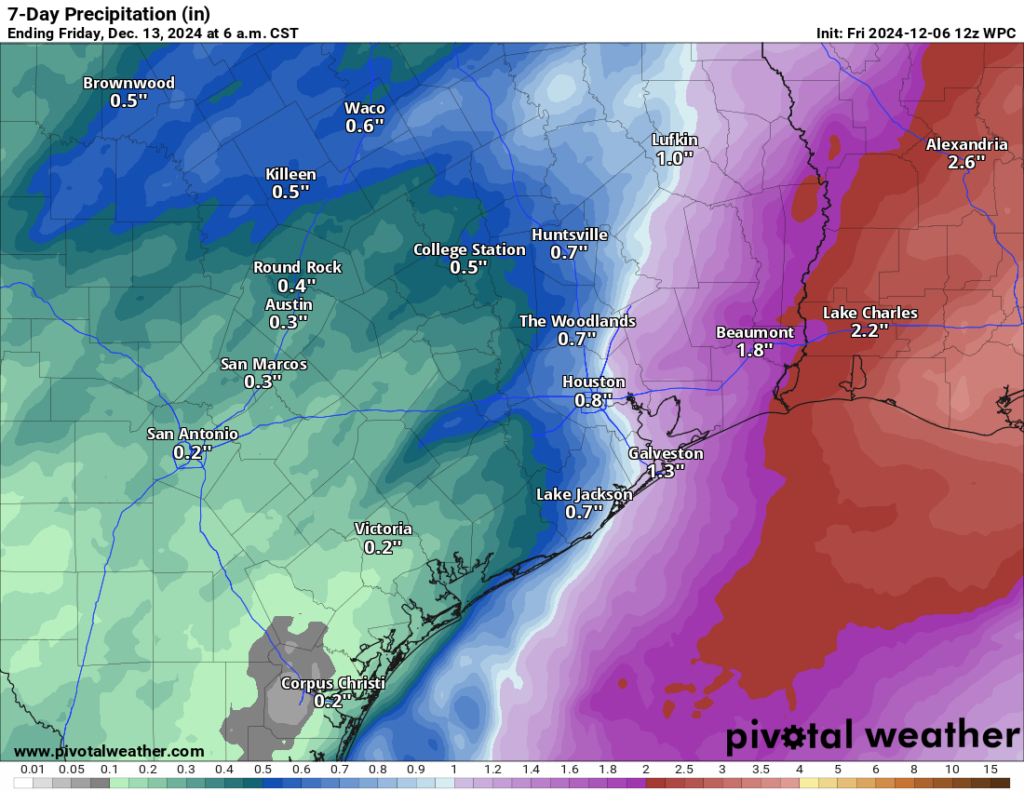
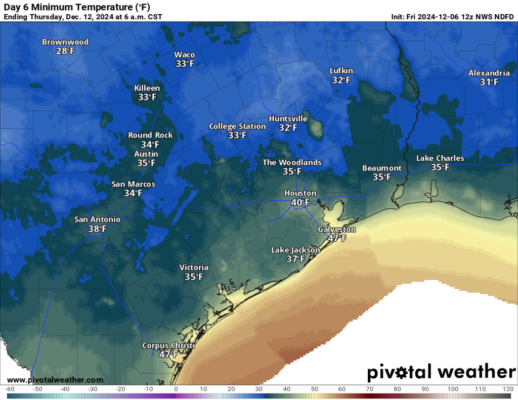
In brief: Will Houston manage another freeze this winter? We discuss what’s been in the news. Rain totals this weekend seem to have backed down some but there will still be some serious temperature and humidity changes into Monday before the coldest air of winter so far arrives next week. A light freeze is possible by Thursday morning outside the city.
Will Houston see a serious freeze this winter?
In the news lately has been ERCOT’s reported prediction of a “greater than average” chance of an extreme cold event this winter. Full disclosure: I know Chris Coleman personally, and he’s a solid forecaster and a good guy. ERCOT uses the fact that 5 of the last 8 winters have seen an extreme cold snap in Texas, as well as the fact that the majority of our extreme cold events since 1950 have occurred in La Niña winters. Interestingly, many of those cold snaps have occurred in otherwise mild winters, including 2016-17, our warmest Texas winter on record! So are these events indeed happening more frequent, or is this perhaps the law of averages catching up with us?
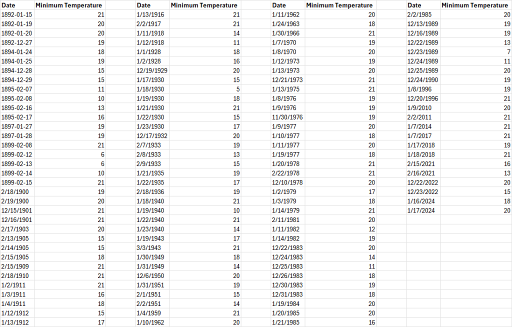
Going back to the 1800s, Houston has officially hit 21° or colder a total of 124 times. As noted, we’ve done it in 2024, 2022, 2021, 2018, and 2017. So it’s been a busy stretch, in addition to a few other instances in 2014, 2011, and 2010. But prior to 2010, we had last done this in 1996. So we went 14 years without hitting it once before racking up a bunch. The only real comparable stretch to that gap was 1918 to 1928, when we got shut out of sub-21° nights. You’ll notice from the data above that while the quantity of years seeing extreme cold seems to have revved up some in recent years, the duration of these cold spells seems to have shortened. And you see fewer winters with multiple extreme cold spells. Some of that is urban heat island effects due to Houston’s enormous growth. Some of that is the warming Gulf of Mexico in our backyard and/or climate change. But mostly, it’s actually kind of typical to have this type of cold in Houston every few winters. Yes, it’s been busy in recent years. But I think that’s more a consequence of having experienced few major cold snaps between 1996 and 2018 more than anything.
So what are we saying? It probably makes sense to prepare every winter for a pop of extreme cold. It may only last a few days, but it can obviously cause problems. And to the original point about this winter: Given the La Niña in place, there should be an ample reservoir of cold built up in Canada by later January and February. It’s a weak La Niña to be sure, but it should still allow for more Canadian cold than in a typical winter. If the wrong setup comes along to dislodge that into the Plains, that’s when we could experience a pop of extreme cold this winter. Putting all this together, it’s not at all illogical to state we have a greater than normal chance of experiencing a brief extreme cold outbreak this winter. Coleman also mentioned in his ERCOT presentation that for cold weather, “This is like a tornado watch. Doesn’t mean a tornado is going to happen. It means conditions are there.” And I think that’s the key takeaway from all this. And it’s also something Eric noted in our commentary on winter back in early November.
On to the weather, of which there is a good bit to discuss this weekend.
Today
We should close the week out on a cool but benign note. There are some clouds pushing northward across Matagorda Bay, toward Wharton and west out toward perhaps Columbus or Sealy. But aside from that, sun and some clouds rule the day. A chilly morning in the 40s should warm deep into the 50s this afternoon. I would not entirely rule out a passing shower before the end of today, primarily between Matagorda Bay and Columbus or perhaps up toward College Station. Nothing big, just don’t be shocked if you feel some raindrops.
Saturday
Tomorrow will be our transition into a temporary warm pattern, priming us for a wet Sunday. Look for clouds and kind of damp, raw weather on Saturday as humidity levels increase. We’ll manage the mid-50s or a bit milder for highs but between a few showers, the cloud cover, and that rising humidity, “clammy” may be an appropriate descriptor. Look for some low clouds or drizzle in spots in addition to passing showers here or there.
Sunday
More numerous showers seem likely on Sunday across most of the region. The area is in a marginal risk (level 1/4) for excessive rainfall. At this point we think that the only flooding would be typical ponding issues on area roadways (ex: frontage roads) or in small areas that see brief street flooding due to downpours. Modeling seems to have backed down on the amount of rainfall to expect and rain totals have generally been cut as a result.

The best ingredients to sustain rainfall will be to our east, so places like Beaumont or Lake Charles will be more apt to see more rain it seems. Temps will surge on Sunday though as warm air floods in off the Gulf, along with breezy conditions. Look for highs well into the 60s.
Next week
There will be a disconnect between this weekend system and the incoming cold front, so Monday falls firmly in the warm category. We’ll manage highs into the 70s with a good bit of humidity. The cold front hits Monday night, which as of now looks fairly dry. It appears a secondary front arrives Tuesday afternoon. The combination of the two will allow for Tuesday’s temperatures to drop into 60s for highs and allow for the coldest air of the season Wednesday night.

Some places will approach freezing Wednesday night and Thursday morning, primarily north of Houston and outside the city. Daytime highs on both Wednesday and Thursday will limp into the upper-50s or low-60s at best. A somewhat more sustained warm up may follow next weekend and into the week of the 16th. More to come.


Studies have linked colder U.S. winters with autumnal snow cover in Eurasia as well. Currently the snow pack is much more widespread than it has been over the last few winters. So that may play into their thinking as well. The Canadian Prairie and most of the Mountain West regions are running above average. Both of the arctic outbreaks in 1983 and 1989 came just before Christmas so we will see if history repeats itself.
I was 9 years old in 1989 and remember that Christmas freeze well. We had a pipe burst and had to move in with my grandparents over Christmas. As a kid, I thought it was magical. Ha! My poor parents! What a Christmas for them.
It can get as cold as it wants as long as our glorious overlords can keep the power running.
Ch 13 has high of 50 Tomm with rain. That’s chilly here, but here it’s saying warming trend starts Tomm with humidity going up making it feel clammy. I’m confused. The communication and differing opinions is mind boggling.
Why do you give any press to ERCOT? They are a horrible organization and should be punished for the lack of empathy and compassion shown during previous winter storms!
Once again, you clearly have no clue about the role ERCOT plays in the power grid. ERCOT is the electricity broker, plain and simple. If you want to blame anyone, look to the producers.
The electricity supplier Center Point with their smug, over inflated executive salaries are the real enemies.
Not pointed at y’all, just a gripe. But I’m over here on the westside getting real tired of projected rain totals going from 4 inches two days ago to maybe a half inch today. Seems to be happening much more often than it used to. The projections shoot way high, come down to almost nothing, and then we have been lucky to get any rain at all. Had to take down my second of two pine trees in the front yard this week due to all the droughts. Just complaining. Sorry – I miss the rain.
Yea short range models are getting worse, and unacceptable. Changing forecasts last minute and events flat out not playing out
Yes! I can’t remember the last time the precipitation estimates have been accurate. It’s always less than half of what is initially projected.
I’ve noticed the same thing not that weather forcast have ever been good, but they have been especially bad these past 2 years.
Inaccurate forecasts do not only happen here, this from a site in the UK:
“How can our weather forecast apps all be so wrong every day? Several of them said 20% chance of rain today.
Well I can tell you it’s not only raining but it’s like a very cold monsoon outside — I’m just in — soaked through to the skin and needed a shower more to get some heat back in my body.
I can’t remember a day it didn’t rain this year.”
I’m not terribly shocked, truthfully. I guess being in a weak La Niña and this pattern is still enough to mitigate rain totals a bit. The base state of the atmosphere probably wants to go dry. I will say, this is one of the more impressive 24 hour shifts in expectation I’ve seen in a while. Unfortunately this was across most reliable guidance. I will say that AI models did not overinflate totals to the extent some other model guidance did. That feels counterintuitive to me though, but it may mean we need to put more stock in those for precip too.
Lanza. I have said for many years. You are the best. Merry Christmas.
Two words: clicks and views.
“A somewhat more sustained warm up may follow next weekend and into the week of the 16th”
Oh no here we go with 70s and 80s again probably through Christmas.
Yep, I predict 80s for Christmas. We haven’t gotten a few weeks of sustained Cold Weather yet this year. Maybe in January…
For what it’s worth, weeks of sustained cold weather almost never happen this early. I would argue that they barely ever happen at all.
That is very true. Most of our coldspells are short-lived. Even when we do see sustained cold weather, it is usually in January, most years. Since 2009, we have only had like 4 Decembers where we had a longterm cold pattern persist through the first half of the month. 2009, 2011, 2013, and 2017
I blame the gloom on what I have dubbed the Hallmark Syndrome, which is expecting the unreasaonable in the weather and life in general. Maybe they should make some warm weather Christmas shows.
That we may likely get a cold snap this winter is only news because nowadays a cold snap means that the power will go out for days. What happened in 2021 seems destined to occur again.
I’ll never forget that cold Christmas week of 1983.
On Christmas Sunday morning, 1983, Bush Airport probably bottomed out at 11° Fahrenheit. New Year’s Day Sunday morning, 1983, the low temperature at Bush Airport was maybe in the 30s, F.
I remember that 7 F record on Dec 23, 1989 very well. It was 6 F in Sugar Land and 8 F in Port Lavaca. I had just left TXU and called my boss back in Dallas with a record -4 F. He replied that they were burning 330,000 barrels (14 million gallons) of fuel oil (diesel and fuel oil #6) a day to make electricity and barely hanging in there. He asked me once again to come back but I said no once again.
My middle brother and I walked out on the sea ice in Lavaca Bay over a quarter mile and suddenly realized that we were standing on ice over ten feet of very cold water. We hurriedly made our way back to dry land.
Matt,
“Today”
Reading between the lines, your observation about the clouds over Matagorda moving toward Wharton is prophetic. For years we would fish for specs in Matagorda Bay in the early morning, beat it back to Doc’s Dock then race the rain clouds to Wharton, on to Sealy, Bellville then back to Pinehurst only to get drenched as soon as we pulled into the driveway. I always wondered if it possibly could be the same rain cloud that chased us back to the dock. Now I know- I think?