In brief: In this afternoon’s post we discuss what we think will happen in Houston and surrounding counties with the forthcoming winter weather, and when it will happen. We also have some advice for people making closure decisions, and an opportunity for you to ask questions later today.
Ask me anything today
We’ve gotten a ton of questions, as you might imagine, about impacts from the freeze, and what it means for getting around Houston and traveling beyond the city this weekend. I’m going to set aside some time, beginning at 4 pm CT today, to answer your questions on Facebook. I’ll create a post and take your questions there. If you don’t use Facebook, don’t worry. We’ll collect some of the best and most-asked questions and repost them here on Space City Weather.
Wait to make closure decisions, if you can
We’ve also heard from business and other entities making decisions about closing on Monday. I fully recognize that everyone has their own timeline, and prefers to give people as much time to make accommodations. All I would really like to say here is that if you can wait to make a decision, it is probably in your best interest to do so. There are scenarios in which the “winter storm” this weekend has relatively modest impacts on the region and our roads. There are also scenarios in which the ice accumulation is enough to shut things down on Sunday and Monday morning. What we’re struggling with as meteorologists is just how crippling the impacts will be. Right now Matt and I are leaning slightly toward “modest” rather than “crippling” impacts, but it us just too early to say for sure. Anyway, if you need to make a decision today, you should err on the side of caution. If you can wait another day or two, you may benefit from better weather information.
Winter storm forecast
The forecast, as we’ve outlined for the last 24 hours, remains more or less on track. So for this afternoon’s post I thought I would do a post about what to expect, and when.
Friday, Friday night, and Saturday
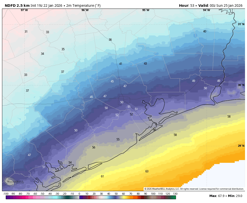
This period should be moderately warm, with increasing rain chances on Friday evening and for much of Saturday. Although the cold front will arrive on Friday, it is going to take a secondary push before the Arctic air really pushes in. So on Friday we can generally expect temperatures in the 60s, with overnight lows in the 50s, and then temperatures in the 50s (perhaps 60s closer to the coast) on Saturday. This means that, when the majority of precipitation falls on Saturday, it’s going to just fall harmlessly as rain. That’s great.
Saturday night and Sunday
That secondary push of colder air will arrive sometime on Saturday night. We think it will arrive late enough such that getting around Harris County should pose no problems through at least 9 pm CT on Saturday. (This deadline may come a little earlier in Montgomery County, where temperatures will be quicker to reach freezing level). After this point we’re not quite sure how cold it will get, and how quickly. Let’s quickly go over two scenarios:
Slower Freeze: There is a world in which air temperatures on Sunday remain in the 33 to 40 degree range in Harris County and other parts of suburban Houston (outside of Montgomery County). At the same time we would see the end of showers on Sunday, and some sunshine during the afternoon to help dry out roads. In this scenario mobility issues on Sunday and Monday morning are mostly ok, although we would definitely have some concerns about bridges and overpasses.
Faster Freeze: In this scenario daytime temperatures drop to freezing during the daytime Sunday in Houston and surrounding areas, and we continue to see precipitation that falls as freezing rain. This accumulates on Sunday afternoon and there is no time for it to melt or evaporate before a hard freeze Sunday night. In this case driving around Houston on Sunday, Sunday night, and Monday is rather hazardous.
So which will happen? We just cannot predict with any confidence right now. Sorry. The European model and some of our emerging high-resolution guidance support the “slower freeze” scenario, but there is plenty of data to support a “faster freeze” scenario as well. Hopefully things will clarify in the next day or so, but no promises there.
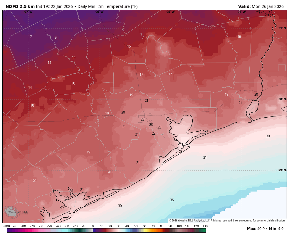
Sunday night into Monday
It’s gonna get really cold on Sunday night, with temperatures likely falling to the 20 to 24 degree range in urban Houston, with colder conditions for outlying areas. This meets the criteria for a hard freeze, so all steps should be taken to protect pipes, plants, and pets. We continue to be hopeful that Monday will be sunny and see temperatures in the upper 30s to 40 degrees, which should solve ice issues on roads in Houston. What I’m not sure about is how far north these “above-freezing” temperatures will extend. For example, will ice melt from roads in Conroe or Huntsville on Monday afternoon? I’m not sure.
What about another ‘winter storm’ next week?
Yes, there is some possibility of another Arctic outbreak during the Friday, Saturday, and Sunday period of next week. Everything from snow on down is on the table. At this point it doesn’t look like absolute air temperatures will get as cold as this weekend, but we’ll just have to wait and see. One disaster at a time, y’all!
We’ll have an update this evening with the best questions and answers from our “Ask me Anything” this afternoon.
