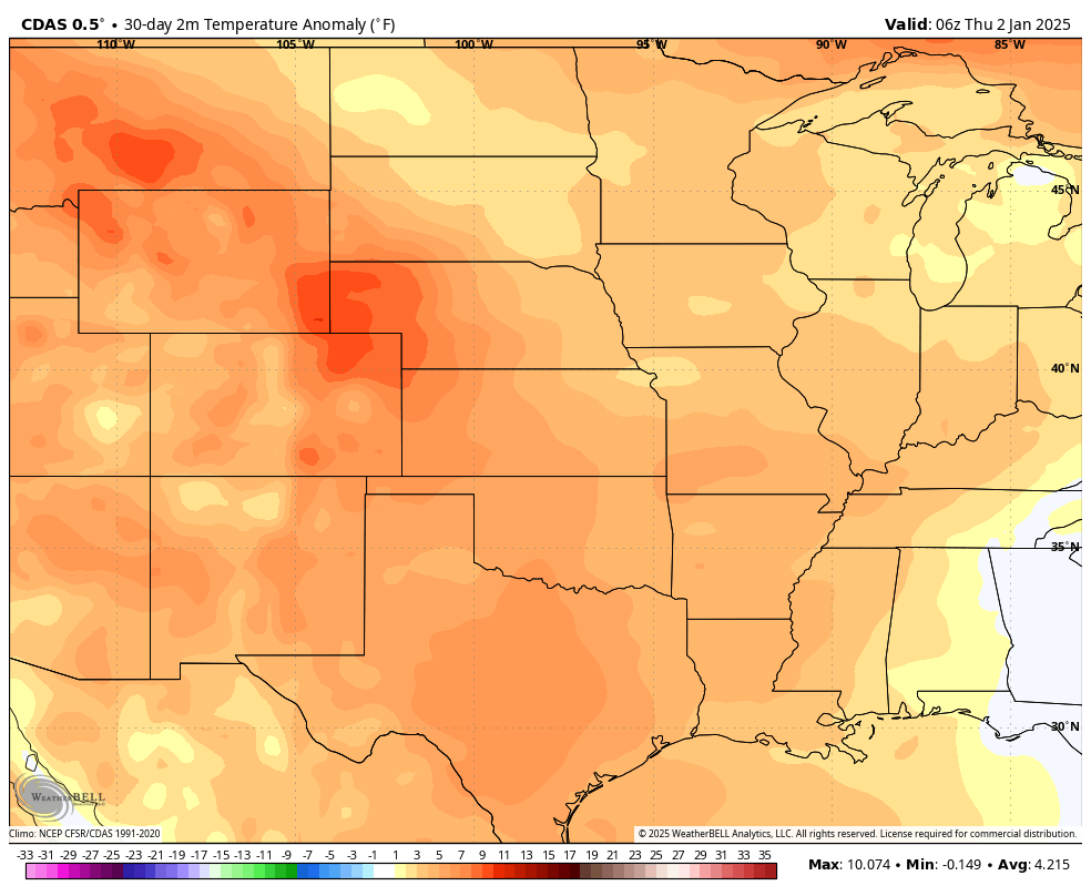
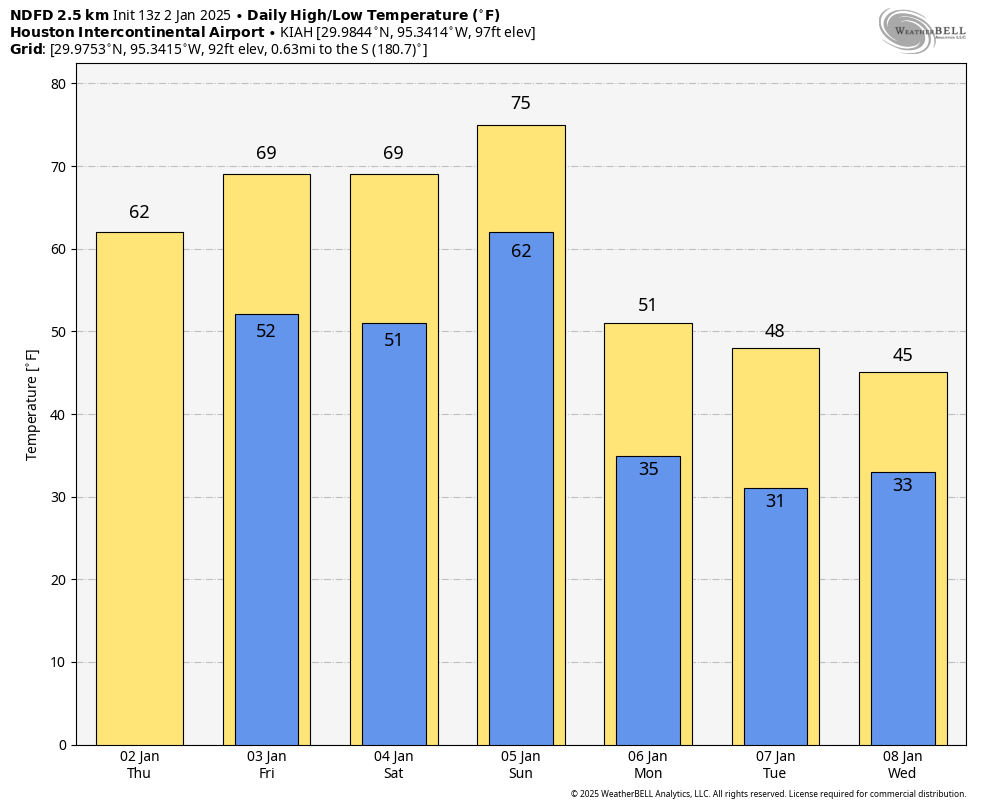
In brief: So far this winter in Houston has been abnormally warm, with December feeling more like late fall than winter. But that’s about to change as an Arctic front arrives in Houston on Sunday, bringing much colder air into the region. However, it’s looking more like the metro area will see a light freeze rather than a hard freeze next week.
Winter so far
There are several definitions of winter, but from a climate standpoint in Houston the three coldest months are December, January, and February. By this definition this winter has, to date, been incredibly warm. December had an average monthly temperature of 61.1 degrees in the city, which is 5.7 degrees above normal. So far the city of Houston has yet to record a freeze at its official monitoring station, at Bush Intercontinental Airport. The lowest temperature so far has been 35 degrees.

Beginning Sunday or Sunday night we will shift into a colder pattern that will stick around. Although there are still some details to be worked out, much of the Houston area is likely to see a light freeze next week. The good news is that, for now at least, most of our modeling guidance has backed off the idea of a hard freeze in Houston. So we are probably not looking at a situation where most of the area falls into the low- or mid-20s. But we will continue to keep an eye on this.
Thursday
Lows this morning have fallen to about 50 degrees, and with a light easterly wind we’re seeing the development of some clouds. Skies will be mostly cloudy for much of today and tonight, with highs likely only reaching the lower 60s. A few isolated showers will be possible today, but I expect most of us will not see any rainfall. Lows tonight will drop into the mid-50s.
Friday
As winds shift to come from the northeast we should see clearer skies on Friday, with highs in the upper 60s to possibly lower 70s. Lows on Friday night will fall into the mid-50s.
Saturday and Sunday
The weekend will be mild ahead of a front on Sunday. Skies on Saturday should be partly to mostly cloudy, with highs around 70 degrees, and a warm night with lows only dropping to around 60 in Houston. Sunday will be warmer, in the mid-70s. The front should reach Houston some time during the afternoon hours, possibly with a broken line of showers or thunderstorms (nothing serious, probably), followed by much drier and colder air. This is a slap-you-in-the-face kind of front with gusty winds coming from the northwest almost immediately. Temperatures will likely fall into the upper 30s by Monday morning.

Next week
The colder weather will stick around for much of next week, although Tuesday and Wednesday mornings now look to probably be the coldest of the period. For much of Houston that probably means a light freeze, with temperatures in the vicinity of 30 degrees. We could be colder than that, or a bit warmer, as it remains to be seen. Highs are likely to be in the 40s for a few days. There’s a possibility of a wintry mix on Wednesday, Wednesday night, or Thursday morning, but this will depend on whether there’s enough moisture for precipitation, and how cold things get. It’s just not possible to say at this time. Next weekend will probably be a little warmer, but still chilly.

bring in your pipes and wrap your pets!
Aye cuid be a wee bit nippy tae be playing th’ pipes in a kilt. 😀
More sensible to wear trews to protect the pipes from getting nipped.
How about an early prognostication for the Houston Marathon being held on January 19th? It’s never too early to begin begging for good weather for the runners!
Its too far out to give an accurate weather outlook for now
It’ll be January – which means it could be mild and humid or freakin’ cold as Hoth. Realistically we need to get to the ten day window before having any real hunches. I’m thankful to only be running the half this year.
Fortunately – for me – my runner isn’t running this year – hip issues so he says – so I will not have to be chilled standing on a street corner waiting for him to drag his sorry arse to the 20 mile point if the temps drop.
Would have preferred this on Christmas week, but BRING IT ON! 🙂 🙂 🙂
So which days will Centerpoint mismanage the grid and cut the power killing more people with zero repercussions?
That will only happen on the days that end in “Y”
🙂
Get ready to start talking’s about the Houston Marathon weather… I know there’s no definitive answer yet, but just keep it on your radar as many of us runners will be talking amongst ourselves about it… As we do every year! 😃
Keep the winter going I am a January guy it’s also my birthday
As long as my pipes are safe, the grid holds, and my heat doesn’t randomly break, low 30s are fine with this former Michigander.
Fellow former Michigander here… that’s asking a lot.
But the grid in Michigan is notably lousy these days too, from what I’ve read. I wonder if DTE has been bringing management in from Texas to teach them how to run things “more profitably” (i.e. putting cash into dividends and stock buybacks instead of reinvesting it in infrastructure, cutting every possible corner & putting the risk of failure onto the public, and running off with the money without facing any consequences).
Now that we’re a quarter of the way through the century, I have one question:
WHERE’S MY FLYING CAR??!!
Perhaps you’ll get it in the year 2525 (if man is still alive).
It’s called a helicopter and you need a pilot’s license to fly one.
Weather Channel’s January 2025 outlook shows warmer than normal for Houston. Depending on how long the cold lasts, I have a hard time believing it. That’s why I don’t take those maps seriously.
I guess we can’t rely on December for consistent cold weather anymore. Our winters have been narrowed down to January and sometimes February.
Boo for cold weather! Spoiled by warm December weather!