In brief: Today’s post reviews the winter that just ended in Houston, and assesses how well the forecast did. We also look ahead to the (slight) possibility of storms on Tuesday before a pleasant spring-time week takes hold in Houston.
A review of winter 2024-2025
From a climate standpoint, winter runs from December 1 through the end of February. From a practical standpoint, winter in Houston roughly lasts from that period as well. This year, it almost certainly does, as winter is effectively over in Houston. I’m highly confident the region will not see another freeze this season, and reasonably confident that low temperatures are unlikely to dip into the 30s again for most of the metro area.
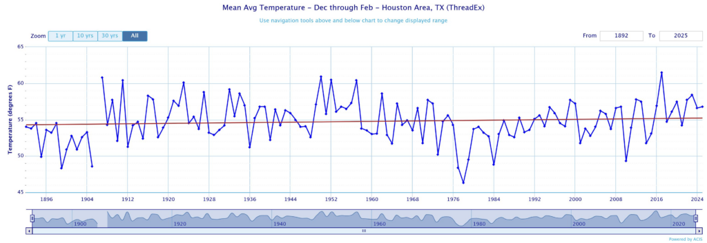
So now that winter is over, let’s take stock in what went down. The average temperature (the daily high and low, divided by two) over the last three months has been 56.8 degrees. This is above the historical mean of 55.2 degrees, and this winter ranks 31st of out of 133 years of records. If we look at the long term trend in the average temperature, it looks like this:
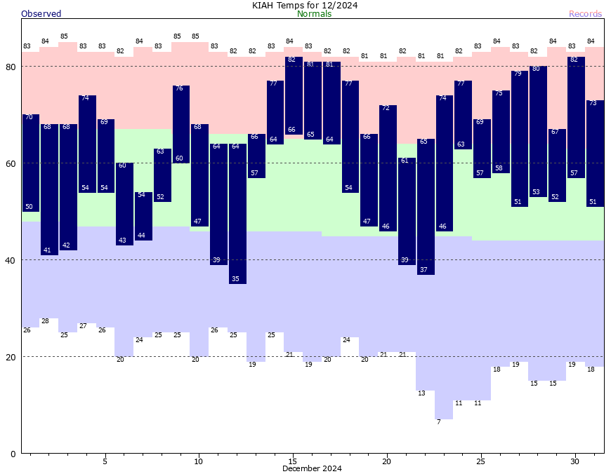
Now let’s dig into each of the three months a little bit more closely to see what we can see. As you may recall, December was quite warm. The month finished with an average temperature nearly 6 degrees above normal. The second half of the month did not feel winter-like at all. Do you remember our muggy Christmas weather?
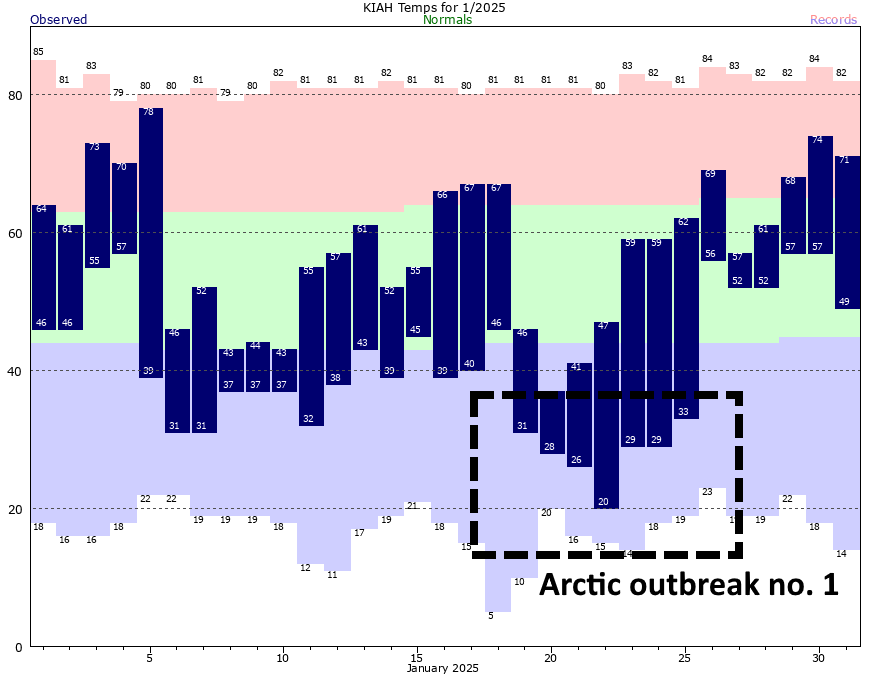
January started out warm as well, but then conditions turned much cooler. During the second half of the month Houston experienced its first Arctic outbreak of the season, with temperatures plummeting all the way down to 20 degrees on one night. As a result of this colder weather, Houston finished January with an average temperature for the month 4.4 degrees below normal.
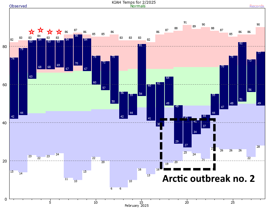
All of which brings us to February. The first third of February was exceptionally warm. We broke or tied four daily records for high temperatures in Houston, and some of our nights saw record warmth as well. But then the middle of the month was defined by the season’s second Arctic outbreak, with a few nights in the 20s. Despite this colder weather, February still ended with an average temperature a little more than 2 degrees above normal.
How did the forecast do?
We issued our winter outlook four months ago. We forecast a relatively mild winter, with temperatures above normal. However, we included this caveat:
However—and there’s always a but in meteorology, it seems—there is one caveat to this forecast. Because of the way this pattern sets up, it will block much of the colder Arctic and Canadian air from the lower United States for most of the winter. But that does not exclude the pattern breaking one or two times. If that happens, and it probably will at least once this winter, there will be a large pool of much colder air available to dip down into the southern United States, including Texas
Essentially, that’s what happened. Houston had a mild winter punctuated by a couple of strong bursts of very cold weather. And now, we’re on to spring.
Monday
After days and days of sunshine, we’re seeing mostly cloudy skies today. Despite a warmer overall flow, these clouds should help limit high temperatures to the mid- to upper-70s for most locations. We will also see a slight chance of light showers throughout the day, but mostly skies will just be gray. As on Sunday, we’ll see some gusty southerly winds, likely picking up to 25 mph or so this afternoon. Lows tonight will only dip into the upper 60s.
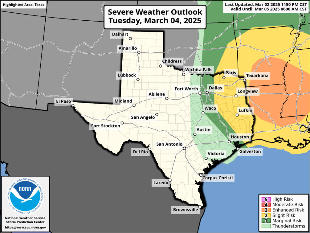
Tuesday
As a front approaches, we’ll see increasing rain chances after midnight, and throughout the morning hours on Tuesday. By around 8 to noon we may see a broken line of showers and thunderstorms develop and push through the area. Although we cannot entirely rule out the possibility of some severe weather, the dynamics favoring strong storms are more favorable to the northeast of the region, where there is a slight risk of storms. Most of Houston will likely pick up a few tenths of an inch of rain. Any lingering rains should end by around noon, with much drier air moving in behind. Temperatures will be in the 70s.
Beginning tomorrow, we’ll have daily forecasts for the Houston Livestock Show and Rodeo, but my main concern is northerly winds. They may gust up to about 30 mph on Tuesday afternoon and early evening before settling down. So, quite literally, hold on to your hat. Lows on Tuesday night will drop into the 50s.
Wednesday and Thursday
These will be a pair of sunny and mild days. We’re talking highs generally in the mid-60s. Expect lows on Wednesday night in the 40s, and on Thursday in the 50s. We should have zero weather concerns during the middle of the week.
Friday
We should see the return of some clouds along with a warmer flow on Friday, with highs in the mid- to upper-70s.
Saturday, Sunday, and beyond
The weather on Saturday will be determined by the timing of a cool front, which likely will push through during the daytime. This may produce a slight chance for some showers, but I expect mostly sunny skies with highs in the 70s. Sunday looks to be sunny, and cooler, with highs in the upper 60s maybe. Most of next week looks mild, with highs in the 70s and lows in the 50s, so the watch word is “mild.”

Thank you SCW. Always glad to see you.
Are the radars going to show what’s really going on in the sky now that they’ve kneecapped NOAA’s data & the poor people there?
I cling to SCW & Windy during tornados. The radar was the only way to tell when I’m fixing to get hit hard. It was like a friend.
Does anyone know?
Oh my
No more radar, ever, anywhere. You will have to rely on the Old Farmer’s Almanac. There will be nothing else, no thermometers, nothing. Space City will be reduced to going outside, looking at the sky, feeling if it’s wet.
Sarcasm is not helpful on a weather forum, thank you very much. If you have nothing nice to say, do not say anything at all. Sara’s concern was real, and you chose to mock her. So shameless, people these days…
Exactly
Check yourself. Get a snickers.
I think we won’t know exactly what’s been cut and which services have been lost until we need them, and they aren’t there. The good people at the NOAA will try to keep up services despite the kneecapping but a skeleton crew probably cannot do it all, point blank period. People will not get the information they need, and I feel like people will get hurt because of it…
Follow Reed Timmer on social media.
If he’s in your area it’s a bad sign.
(I wish I had a genuinely helpful answer, lol)
That line fitting the temperatures since the 1890s looks pretty flat.
The start of the best fit line is just above 54, and the end is just above 55, so there is a slight, steady increase of about 1 degree F which correlates to 1.8 degrees C.
A best fit line is not the best or most scientific way of determining average temperature change, yet this still aligns with better data suggesting an average rise of 0.11 degrees F per decade since about the 1850s. This rise has been measured to be greater (about 0.3 degrees F per decade) since the 1980s. Looking at the tail end of the graph above, one can imagine a best fit line from the 1980s to today would be steeper.
1 degree F is 0.56 degrees C.
0.11 degrees F is 0.061 degrees C
Winter in Houston now runs from January 1st through parts of February.
I just want a winter that is consistently cool/chilly with only brief warmups like we used to get instead of these winters where we bounce back and forth between pipe bursting freezes and weeks in the 80s in between like we get now. We used to could rely on El Nino for cold winters, but I’m afraid with the warming climate, colder winters will not be possible anymore even with El Ninos.
Winter now looks much like it did from 1906 through about 1960…
I’m curious if we can remove the Freeze Mizers from water spigots and water trough floats? My husband installed 15 and he passed away Feb 7th so I’m trying to do what he’d do.
💓
Well, I suppose you could cut down a 200-year-old live oak tree and examine the rings.😆 I hope I don’t upset the sarcasm police!
^^^This was directed to Joey.
That crossed my mind 🤣🤣
I’m so sorry for your loss. I’d suggest asking at your feed store if you don’t get a response here.
We got almost no break from the heat and humidity. We did not get a legit cold front until mid november if i remember correctly, and that did not last long. We essentially had December and January to cool off and now we are back to 80+ degree weather until who knows when, november?
It looks like the 1890s and 1970s were the coldest decades for winter in our region. The 1950s was the warmest for winter. To bad we don’t have data for the past few centuries. I am very curious to know the daily in and outs of our weather and climate through the past several hundred years and beyond.
The Guardian posted an article tis AM that there might be another stronger polar vortex event in 10 days or so. Any idea if that is possible? Already a subscriber.
The guardian?!?! Hmm, okay … 👎
Re comments on NOAA…my take not troll – automate the data collection, keep maintenance for the instrumentation and computers, self learning AI will break open productivity. AI finds thousands of minute correlations to model weather. Love the words at NWS, but really just give me the weather animations two weeks out and the Doppler to see what’s happening now. 97% of folks just want to know if it going to rain tomorrow anyway. For more, there is a subscription. As for continuity – missing the derecho and messed up Beryl path here is not a high bar – maybe AI is better…..Weather balloons would be nice for cape but Houston doesn’t have one. What am I missing?
PS March 14 is still warm and sunny. I’m guessing that insight won’t be a freebie for long.
Thank you for the graph of winter temperatures you provided. It clearly demonstrates that the current trend in warm winters is nothing new. As a matter of fact the winters from about 1906 through about 1960 look just as warm if not warmer than the last decade or so. The only exception being the extremely warm winter of 2016-2017.
Thx SCW, good post today. for feedback, i would recommend to split this post into 2 posts in the future. Easier to skip 1 part or the other, since the 2nd part was today’s weather outlook & the first part was a lookback review. I know you’ve done this in the past, & for my own 2cents, I prefer that. Thanks again for providing the data to chew on! I especially liked that you literally defined average. Even though its not really a true average, defining terms is key to scientific analysis. And I sort of suspect this is what’s going on behind the scenes anyway with averages, but anyone I’ve ever asked has not known how the sausage is made.
I would like to know where he got those graphs from.
Believe you did an excellent forecast job. We have come to rely on your accuracy. Thank you!
“The average temperature (the daily high and low, divided by two)”
Is that how “daily average temp” is commonly calculated in meteorology? Seems biased towards extremes. Not questioning, just genuinely curious.
You are doing great, whether the forecast was “right” or not. I come here for the explanations.