In brief: The last two weeks have felt very un-winterlike in Houston, but that has changed with the arrival of the first of three strong fronts. Among the things we’re watching for is the potential for a few storms on Saturday, and very cold temperatures during the second half of next week.
The twelve days of February
We started the month of February on an incredible hot streak, including four consecutive days of setting or tying record high temperatures. So far this month, the average monthly temperatures has been 15 degrees above normal, and it’s felt like we’ve been in the middle of spring rather than winter. However, we are now about to flip the script.
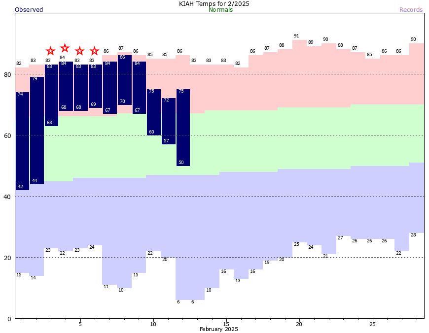
The remainder of the month should bring near-normal and below-normal temperatures, with the potential for freezing temperatures here or there. We are not going to cancel out the extremely warm start to the month, but Houston will feel like winter again—which it should, because we are still in the middle of February.
Thursday
It’s cold this morning, and it won’t warm up much. Temperatures range from the upper 30s north of Houston to the upper 40s right along the coast. Although we should see some pockets of sunshine today, a stiff northerly wind (at times gusting up to 30 mph) will make the high temperature of about 50 degrees still feel rather cold. Conditions will remain breezy tonight, as winds shift to come from the east. Expect lows to fall into the mid-40s in Houston.
Friday
Expect a mostly cloudy day, with temperatures a bit warmer, in the lower 60s. As the flow turns more southerly, we’ll see an increase in atmospheric moisture that could bring some spotty, light showers back into the region. However, overall rain chances appear to be fairly low. Temperatures will not cool off much on Friday night, in fact they’ll start rising after midnight as we continue to see a warmer, southerly flow.
Saturday
This will be a warmer, potentially unsettled day with high temperatures in the upper 70s. There will be a chance of light showers during the daytime, potentially with a line of showers and thunderstorms passing through during the afternoon or early evening hours. Overall accumulations don’t look super high (likely less than half an inch), and while there is the potential for some damaging winds the dynamics are not particularly favorable for severe storms. We’ll keep an eye on it. Lows on Saturday night will drop into the lower 40s.
Sunday and Monday
This will be a cold day, albeit one with mostly sunny skies. Expect breezy conditions and highs perhaps in the low 50s. Expect a cold night on Sunday, with temperatures in Houston dropping into the 30s, and a light freeze possible for some inland areas. On Monday, President’s Day, we can expect more sunshine, and somewhat warmer temperatures in the upper 50s to 60 degrees. It should be a nice day for kids to be off from school.
Next week
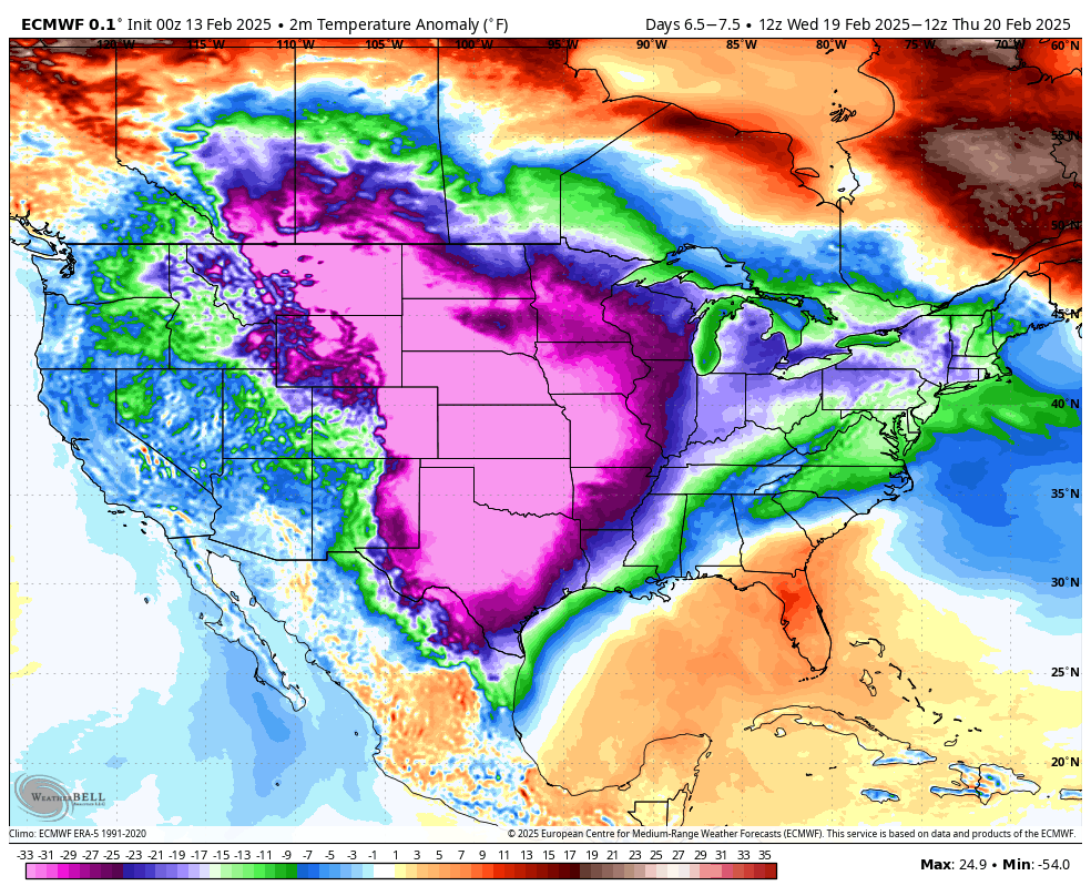
After chilly conditions on Monday, Houston will warm back up on Tuesday and Wednesday. And then? Well, a very serious outbreak of Arctic air is going to move into the central United States. The question is how far the bulk of this air mass drops into Texas, and whether it reaches the Gulf coast. As a result, there is a wide variance in low temperatures during the second half of next week, and I would say anything from mid-20s to lower-40s is possible in Houston. Certainly it is something we’ll be watching for you.

Once again we have another case of GFS model showing 40s while the rest show 20s.
Still better than August, I’d say.
Amen to that. And no hurricanes in the Gulf of Mexico to worry about.
Huh? no hurricane forming in February
I just moved to south Austin.. do you have a counterpart like you here? You have been so wonderful and I would love a no hype guy/gal here…
Was wondering the same for DFW … would be cool if SCW could expand their scope to Dallas
If you’re on FB, there’s a group called Texas Storm Chasers (Texas Weather Center) that tends to cover the DFW area. They do also have an app called Texas Storm Chasers that I believe they publish daily update videos to.
They also have an informative YouTube channel under the name Texas Weather Center.
If you’re on FB, there’s a group called South Texas Weather Updates that stretches their coverage up into Austin. I don’t believe they have a daily published site like this though.
Just curious: It seems to me that Austin is growing north and west – like a wild fire – but is it actually growing south as well towards Bastrop?
Ginger,
Just curious: It seems to me that Austin is growing north and west – like a wild fire – but is it actually growing south as well towards Bastrop?
Our weather this year has had more twists and turns than an M. Night Shyamalan movie plot. Derecho’s, hurricanes, droughts, freezes, near blizzards, winter heat waves. What’s next?
Don’t ask.
It can always get worse.
Another amen to that. I was thinking volcano or asteroid strike…. Oops, that’s not for eight years.
That is a good one 🤣👍
Hell even this winter has had more twist and turns than an M. Night Shyamalan and David Lynch movie. From record warmth, tornadoes, record cold, snow, back to record warmth, we have literally seen it all this winter.
Massive sea level rise.
Anywhere from 20s to 40s. Given the history of our stupid climate I fully expect the warmer outcome.
Decent weather for St. Valentine’s day. Great day to be outside it seems
I swear if I have to bring those potted plants inside the apartment one more time….:p
Keep all hands and feet inside the car until it comes to a complete stop.
I never like to see the actual low temps be higher than the average high temps. That graph really highlights how abnormally warm it was.
Oh my goodness. Cold weather in February? I wish this climate change would stop. I don’t think my begonias will survive.
Yes, I agree. I wish this climate change thing that caused almost 2 weeks of highs in the mid 80s in February, leading to the warmest first 11 days of February on record would stop.
Gotta love these people.
“OMG It was cold for two whole weeks in winter? Climate change is fake!”
Exactly, and totally ignoring the seven other weeks it was anomalously warm this winter, not to mention the record-warm fall. But two weeks of colder-than-usual weather vs. six months of much warmer-than-usual weather, and the usual suspects scream that global warming is totally fake. LMAO!!