In brief: We’re continuing to track the potential for heavy rainfall in the greater Houston area due to a tropical system in the southern Gulf of Mexico. Whether or not it becomes Tropical Storm Alberto, the effects will be the same for Houston. We now think the period of Tuesday afternoon through the middle of Wednesday will have the highest chance for heavy rainfall.
On Monday afternoon the National Hurricane Center said it would begin issuing forecasts for a “potential tropical cyclone” in the southern Gulf of Mexico. This is the tropical system that we’ve been talking about for several days now. This action indicates that hurricane center forecasters believe the system is likely to become a tropical depression or storm (it would be named Alberto) in the next day, but it has yet to do so.

In truth, this changes virtually nothing about the forecast for elevated easterly winds, higher seas, and heavy rainfall that Houston will experience over the next couple of days. The purpose of this post is to attempt to set some expectations in terms of timing of the worst of the rainfall. Tropical weather is inherently unpredictable, but now that we’re closing in on Tuesday and Wednesday, our confidence is a little bit higher. Emphasis on a little.
Monday evening and overnight
As expected we’ve seen scattered showers and a few thunderstorms today, and generally I expect this pattern to continue this evening and overnight. These storms should pose no threats for flooding risks beyond putting a damper on outdoor activities.
Tuesday
Generally, I expect Tuesday morning will not bring anything too crazy in terms of sustained heavy rain. However, by around noon or shortly after that it appears a deeper slug of tropical moisture will move inland into the upper Texas coast. This is when we expect the development of more widespread showers, especially along and south of Interstate 10. The heaviest rain is likely to fall closer to the coast, because that is the source of the moisture. It is too early to say whether heavy rainfall on Tuesday afternoon and evening will impact commute home, but it’s a distinct possibility.
Tuesday night and Wednesday
Our modeling continues to suggest that the heaviest rainfall will arrive later on Tuesday, and persist through Tuesday night through much of the day on Wednesday. By Wednesday evening or night, it does appear that the the worst of the rains will be exiting to our west.
I’m hesitant to speak about accumulations with too much certainty. There continues to be a lot of noise in the models about what to expect. There are some scenarios in which the bulk of the heavy rainfall goes south of Houston (and Galveston) on Tuesday and Wednesday. In this case the region (even coastal regions) might pick up only a handful of inches of rainfall—totally manageable.
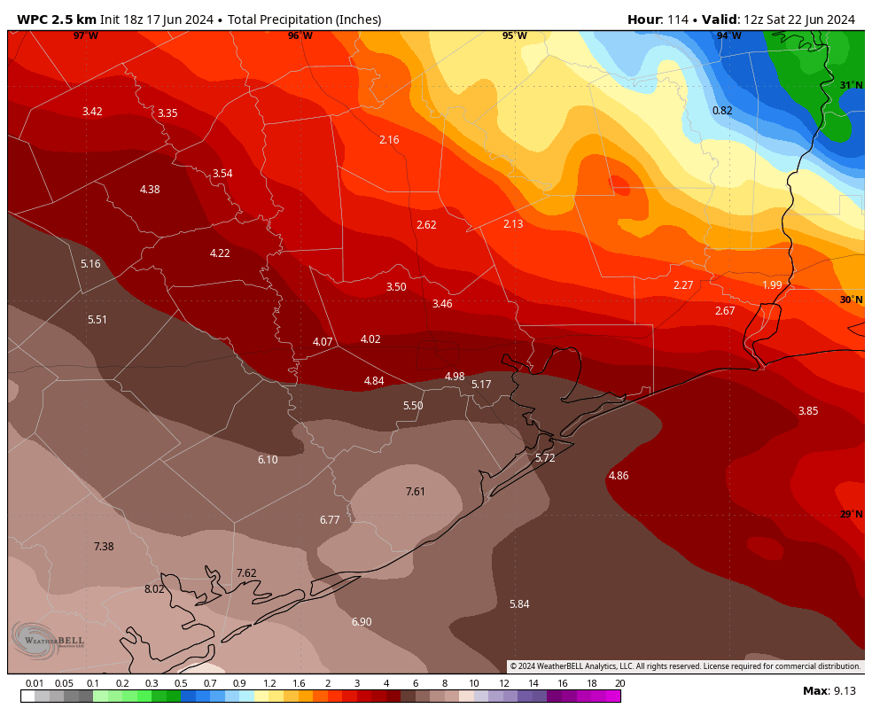
However, I would rate as slightly more likely the possibility that the southern half of the Houston region picks up 4 to 8 inches of rainfall through Wednesday, with higher isolated amounts. This, obviously, would create some flooding issues and is the reason why we’ve instituted (and maintained) a Stage 2 flood alert for the entire region through Wednesday.
The thing with tropical rain is that it comes in bunches. And with this system, we have the very real possibility that at least some portions of our area will see sustained tropical rainfall during the next 48 hours. So please be prepared for that possibility.
Our next update will be posted early on Tuesday morning.

Omg let me prepare the boat and pack my sidechicks as well
Anything predictions about flights out of Houston being delayed Wednesday?
We have one 945am Wednesday out of hobby. I’m also concerned with the answer to this.
I’ve got one at 630 am on Wed out of Hobby. Not too optimistic at this point.
So…should Katy begin to evacuate?
Everyone within 300 miles of the coast should already be evacuating.
😆 It never gets old!
Throwback to IKE
It was Rita.
25 long, hot hours to SA.
Katy, you have evacuated so many times, you must be a mere shell by this time.
Everyone in Katy should hunker down at Torchy’s Tacos.
A cheeky Nando’s might not go amiss!
Will the storm effect flights on Wednesday ?
It’s possible!
On infrared satellite it looks like there is heavy rain from just south of Galveston all the way through the Caribbean to just south of Jamaica. It also looks like the banding is starting to tighten up around the Bay of Campeche. A little ominous looking…
Yeah, not liking that very much
I’m having sod laid as I write, so it had better rain or I am going to be asking some very sever questions.
Me too. Was supposed to be put in Saturday but they couldn’t make it. Finally got it down today. Bring on the free water!
Can someone give me an idea of what is included in the area “South of Interstate 10”?
look at the map in the article to see what areas are south of I-10
I think Eric is doing a good job of giving us information on this event as they say. As he has pointed out several times, what to expect based on past results I tend to trust these guys One thing to remember is the high-pressure which seems to be north of us towards the East Coast, which will keep the storm from going straight north or north east I think expecting Eric to know what’s gonna happen at Hobby Airport is going to be a stretch
Do you think he will have any insight on how this will affect drive-thru lines at Whataburger ( south of I-10)?
I too am curious to the answer of this question…..
Eric – can you explain why the coastal flood warning graphic is showing so far inland? Normally, it shows immediate coast only.
On some National Weather Service maps, the coastal flood warning is the same green color as the flood watch. For inland counties the green means flood watch. (They should use different colors for coastal flood warning and flood watch.)
Thank you!
I’m fully expecting a few tenths of an inch of rain from this event.
I know y’all focus on Houston but throw in a precip chart for the parts of the state south and west that are expected to see even more rain, if you could.
Go check out their companion site The Eyewall for more coverage of that region including a precipitation map.
They have that on the Eyewall.
I have a Botox appointment on Wednesday morning in Bellaire. do you think it will be ok? Should I reschedule?
Possibly, depending on what part of the body is receiving the treatment.
Looking at this radar shot it would deem Louisiana is much more likely to get heavier rainstorms
I base all current and future events on Harvey..I got 56 inches of rain. Wading through waist deep water in the yard at night to save my car by moving it to higher ground, I spotted a very frightened alligator swimming next to me. We survived Harvey, and Ike and Rita.. this will be rather minor.
Where in the Houston area were you?
Not during a freeze!
Well, 9:30pm Mon night.
Nothing at all in Magnolia… much less anywhere else. The “rain” is south of the western coast of Louisiana, so southeast of Beaumont.
And it’s dwindling. Yawn.
And? Most of the rain is forecasted for Tuesday evening through Wednesday evening.
So is it just me? I’ve lived here 37 years and never heard a tropical depression or storm called a “cyclone”…why the terminology change? I always thought hurricane vs cyclone vs typhoon was geographical…cyclone seems much more “dramatic”