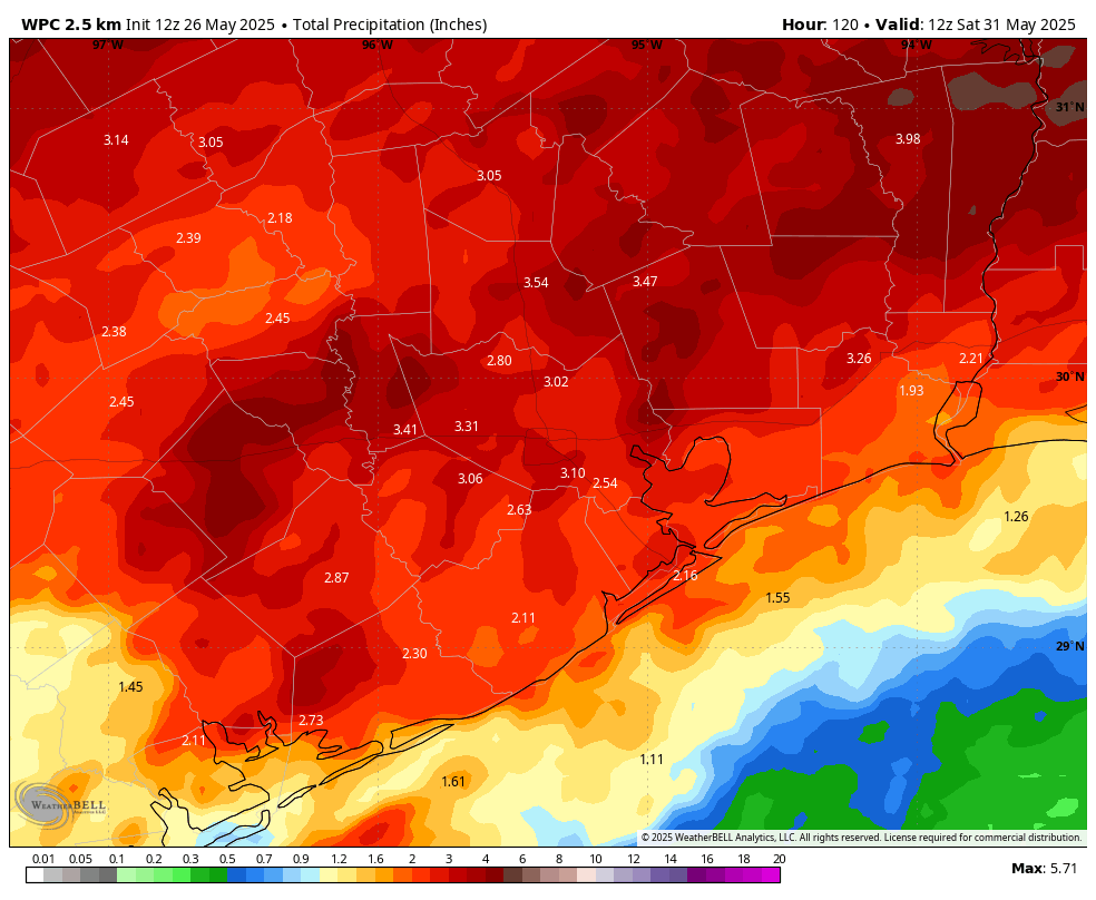
In brief: We hope everyone is enjoying Memorial Day weekend, and we join in remembering all of the US military personnel who gave their lives for this country. The weather should be fine for outdoor ceremonies today. However, Houston will face a series of storm systems this week, including a potentially impactful event tonight. Most of the region should see some much-needed rainfall during the next seven days.
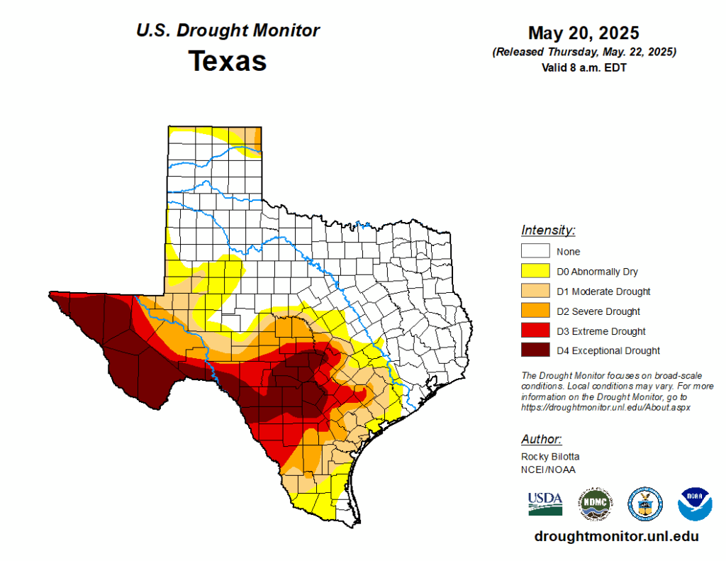
Not a drought, but close
The second half of spring has been fairly dry. Drought conditions are much more acute in central and West Texas, where an exceptional drought has developed ahead of summer. Although Houston is not in a drought, abnormally dry conditions have moved into Brazoria and Waller Counties, with a moderate drought southwest of there. Now that we are approaching the hottest and often driest part of the year, these drought-like conditions would spread into Houston rapidly in June, in the absence of rain. However, as the forecast for this week indicates, that is now unlikely to happen.
Memorial Day and night
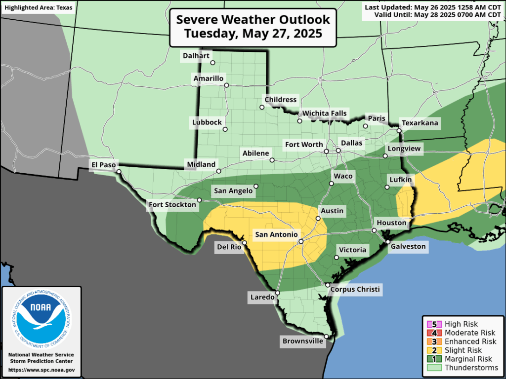
A series of disturbances will impact our area’s weather this week, and the first of these is already propagating to the north of College Station this morning. I anticipate that the majority of this activity will remain north of the Houston metro area, likely along Highway 105 and points north in Montgomery County. But we can’t rule out some activity further south. Skies in Houston should be mostly sunny today, with highs in the low 90s and gusty southerly winds. Humidity will, accordingly, be high.
Another disturbance should move into the region this evening, perhaps not reaching Harris County until midnight or later. This has the potential (and the emphasis here is on potential, given the uncertainty) to bring more widespread showers and thunderstorms into the entire region, all the way down to the coast. The most likely time for significant activity is between midnight tonight and noon on Tuesday. Some hail and damaging winds will be possible during thunderstorms, and most locations should pick up 0.5 to 2 inches of rain.
Tuesday, Wednesday, and Thursday
After these storms we’ll remain in an unsettled pattern for the remainder of the week. Each day will have a healthy chance of showers and thunderstorms, perhaps on the order of 50 percent. Accordingly, high temperatures should be in the upper 80s with partly to mostly cloudy skies. To be clear, these days won’t be total washouts. But pop-up showers will be possible at any time.
Friday
By Friday the overall pattern may start to change a little bit, but with an unsettled atmosphere lingering there still will be a decent chance of rain, in the 30 to 50 percent range. Expect partly sunny skies and highs in the upper 80s.
Saturday, Sunday, and beyond
By this weekend we should see partly to sunny skies, with highs around 90 degrees. Rain chances won’t go away entirely, but they look to be on the order of maybe 30 percent daily. Next week likely brings us back into the lower 90s, with mostly sunny skies and little to no rain. So stock up this week!

I’m happy that the added cloud cover will knock off a few degrees off the high. The possible rain is a bonus.
It’s hard to understand the summary saying weather should be fine for outdoor ceremonies today because the radar has rain (lemon/cherry flavors on RadarScope) to the northern edge of Harris County and advancing south.
I’m not real happy with RadarScope. While it’s a very technical tool which I enjoy playing around with – who knew about velocity and reflectivity? – the use of colors is again such that real danger would not come thru. MyRadar shows strictly green and yellow virtually no red so that lines up with Aggie’s gentle to harder rain. Thus have no fear of sideways blasting winds as I would be if I saw red on MyRadar.
Here’s to the thing getting further south to the URBAN CORE.
I’m more a fan of enhanced echotops and vertically integrated liquid, that said, relative velocity is clutch as well. Read the tutorials that are available and check out YouTube videos, RadarScope is honestly the GOAT!
depending where you live, rain chances/ amount will vary. So outdoor activities will be possible to do today. Now if your someone who gets mad about rain today, then thats on you for not checking radar to prepare your event
Rain wherever and whenever will be welcome – even during parades (soldiers fought and died even in the rain), but please come to my neck of the woods as well.
Well, not a drop of rain on the west side, as of 4:00 PM
Been a mild rain for about 45 minutes now, up here in Magnolia. It’s now increasing. The temp has dropped down to 72°F.
Nice relief with the rain and temp drop.
Well, unfortunately “can’t rule out” activity in the Houston area became a great deal of activity that is delaying flights in and out of IAH for 2+ hours.
I predict absolutely nothing will happen other than a few mistings of rain here and there.
We got a good drenching rain close to noon today, plus a nice 10 degree temp drop, here in Magnolia.
And as I look at the NWS Radar this very moment, the rain should hit in 30+ minutes. Whoop!
Got two inches at my house in Clear Lake.