In brief: The Sun has reached its highest point in the sky, so why is this not the warmest time of summer? We explain. Also, we take a look at a forecast that includes rising temperatures and reduced rain chances. Beginning Sunday or so, it looks like we’ll be in the mid-90s for awhile.
Summer solstice
Thursday was the longest day of the year in the Northern Hemisphere—but only just. The Sun reached its highest point in the sky over Houston, a peak altitude above 84 degrees, at 1:23 pm CT. The time from sunrise to sunset was 14 hours, 3 minutes, and 31 seconds. Today will be one whole whopping second shorter. But for the next six months our days will progressively get shorter, until the winter solstice on December 21, when the day length will be just 10 hours, 14 minutes, and 2 seconds.
On of the quirks of Texas’ weather is that, while the Sun reaches the highest point of the sky in June, our hottest weather does not come until nearly two months later, in early- to mid-August. This is not true for all of the northern hemisphere, but there is a decided lag in Texas peak heating due to a number of factors. These include weather patterns (pervasive high pressure systems are more common in August than June), and a lag in ocean heating that brings the warmest onshore flows from the Gulf of Mexico later in the summer. Essentially, it takes longer for the ocean to heat up than it does the land.
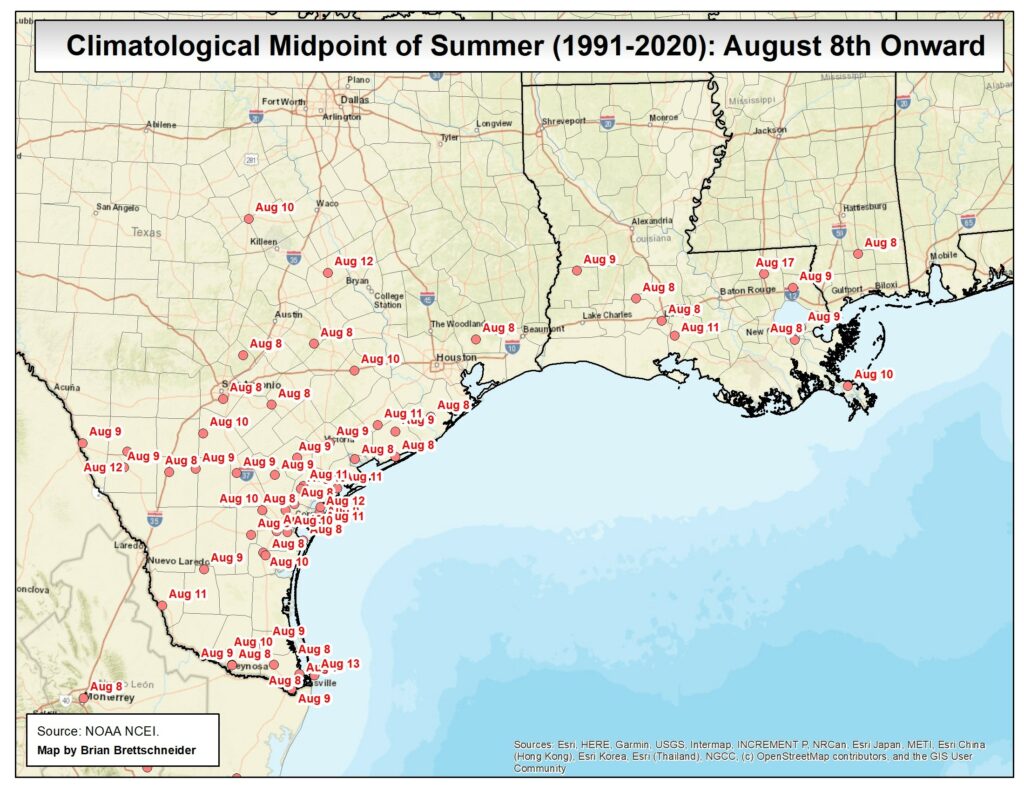
The bottom line is that, even as our days get shorter over the next two months, on average our temperatures will continue to go up. Summer has not peaked in Houston, my friends. Fortify yourselves, because it has only just begun.
Friday
With Tropical Storm Alberto dissipating over Mexico, our seas are beginning to recede and winds have died down. Any lingering coastal flooding concerns should completely subside by this evening. Winds today will be generally from the east, at 5 to 10 mph. What about rain chances? I expect to see the development of some spotty showers later this afternoon. These will be more likely south of I-10, but even then overall chances are low, perhaps 20 or 30 percent. Skies, otherwise, should be partly to mostly sunny with highs of around 90 degrees. Lows tonight will be in the upper 70s.
Saturday
Expect sunny skies, with highs in the low- to mid-90s. Winds will be light, from the east. This will be a great day for outdoor activities, especially those that involve water of some sort. With the Sun high in the sky, please be sure and protect your skin.
Sunday
Skies should again be sunny, with highs generally in the mid-90s. There will be a smattering of rain chances, perhaps on the order of 20 percent. But most of us should remain dry.
Next week
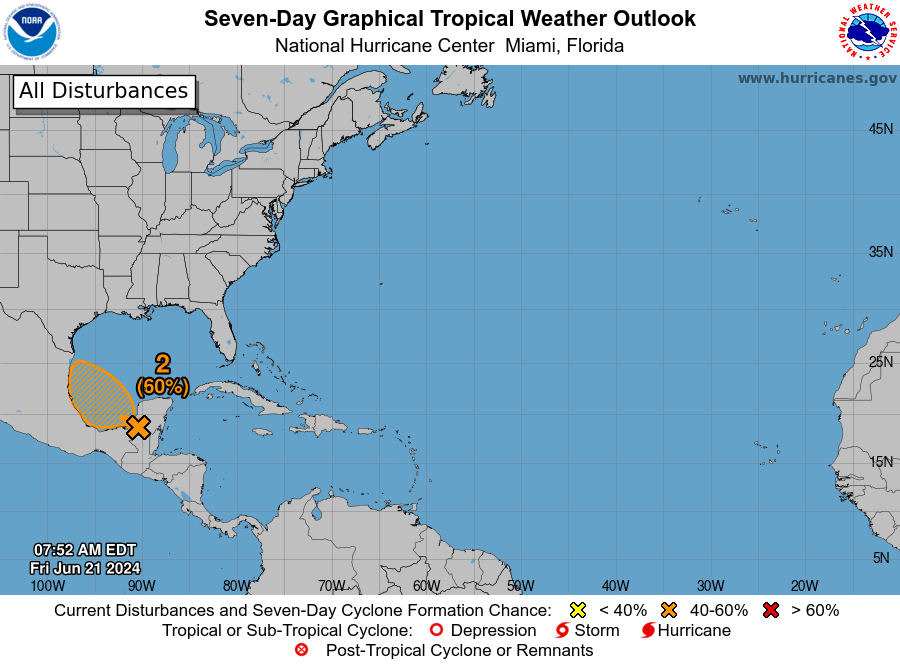
You may have noticed that the National Hurricane Center has highlighted an area in the southern Gulf of Mexico where yet another tropical depression or storm may form during the next several days. This is almost exactly where Alberto formed, but we are not overly concerned this time. Why? Because this system is likely to be smaller than Alberto, so the upper Texas coast will probably see considerably less wind and less coastal flooding. Moreover, with high pressure building over the southern United States, it’s not clear how much, if any, precipitation we’ll see from this second tropical system.
What all of this means is that, for most of next week, Houston is likely to see mostly sunny skies and daytime temperatures in the mid-90s. There will be some daily rain chances, perhaps on the order of 30 percent with the afternoon seabreeze, but I’m not expecting anything too organized. Rain chances may inch up a bit next weekend, but we’ll have to see about that.
Have a great weekend, everyone. After a busy spell, I’m looking forward to not writing about the weather for a couple of days!

Love those positive vibes! Thx
Eric: As always, thanks for an interesting explanation of the lag to go with our calmer forecast. I’m rooting for some cloud cover in the meantime. We do have two more months before peak heating so no one is going to freeze.
Let’s just send that other disturbance to Big Bend to wet the desert and add a few buckets to the depleted Rio Grande.
A lot of people complain that winter days are too short, well I think summer days are too long!
Headed on a cruise to Cozumel this weekend for the next 5 days. Should we be concerned?
I certainly would be. I think you may get a change of destinations……. That happened to us last year.
In some rare cases we actually experience the hottest temperatures of the summer in late June like in 2012 and 2013. It hit 107 on June 29th 2013 in Houston due to a high pressure system filtering hot dry continental air down and compressional heating from an approaching cool front. It was and still is the hottest June temperature on record for Houston
Does the sun have any intensity cycle, and if so, does it affect temperatures of the air or the sea surface?
NOAA is going to trash.
wiping hands
I was taught that through the spring and summer the net radiation balance was positive (more solar radiation in than radiation out) so the atmosphere heats up. The amount of heating decreases until around 9/20 when the net radiation is about zero and then the atmosphere starts cooling. Max cooling is on 12/20 or so. The radiation balance is negative and decreases uuntil zero about 3/20. And the cycle repeats.