In brief: Houston will be hot and sunny for the next couple of days, with only some scattered shower chances. The forecast begins to change this weekend, as Hurricane Beryl moves into the southern Gulf of Mexico. After that there are a lot of questions about what happens next, and this post attempts to address them as best we can.
Some thoughts on Beryl-mania
I want to start today’s post with some thoughts about Hurricane Beryl and hurricane season anxiety. In the last day or so Matt and I have been flooded with questions about this storm and its potential to impact the greater Houston area. Is the hurricane coming here? Will we flood? Are we going to see storm surge? How damaging will the winds be? There is just a ton of noise and chatter out there, and I want to say two things about it.
First, we don’t have the answers to a lot of the questions being asked. There are no absolutes in a five-, six-, or seven-day hurricane forecast. However, as I’ll discuss in the forecast below, it remains likely that significant wind and surge impacts from Beryl will go south of the Houston area. We’re most closely watching for increased rain chances next week. That doesn’t mean the forecast can’t change. But as we’ve been saying for a couple of days, in the big picture Beryl is likely to move inland into Mexico or South Texas, far from Houston. If our thinking changes on that, we’ll shout it from the rooftops.
Second, it’s going to be a long season, y’all. I get it. Beryl is a pretty ominous storm, because its intensity and rapid intensification are wholly abnormal for late June and early July. We’ve never seen this with a tropical system before, and it underscores the notion that this will be a hyperactive Atlantic hurricane season. However, the Texas coast has about three more months during which we are going to have to pay close attention to the tropics. Almost certainly there will be bigger threats than Beryl to Houston this summer, and times for great anxiety. This is not one of them.
Put simply, this is a marathon and not a sprint.
So please trust us when we say this: If you need to be concerned about a tropical system—like stocking-up-at-the-grocery-store or preparing-to-evacuate levels of concern—we are going to let you know as soon as possible. We just haven’t seen that signal yet from Beryl.
Wednesday
The story for the next couple of days will be one of heat as a high pressure ridge mostly holds sway. High temperatures will be in the mid- to to upper-90s through Friday or Saturday. Today we’ll see mostly sunny skies, with light southerly winds. There will be the usual smattering of afternoon and early evening shower chances along the sea breeze, but any showers that develop should be fairly scattered.
Thursday and Friday
These should be the hottest days of the upcoming forecast period, with highs in the upper 90s except for coastal areas, which will be a few degrees cooler. Skies will be mostly sunny with only perhaps a 10 or 20 percent chance of showers this afternoon. The only concern for fireworks on Thursday, the Fourth of July, will be temperatures which should still be sultry and in the upper 80s shortly after sunset.
Saturday, Sunday, and beyond
Rain chances will increase starting Saturday, and then persist through much of next week. From this point forward our weather will be guided by the track and evolution of Hurricane Beryl, and the potential for a trailing tropical system (Invest 96L) that may bring some additional moisture into Texas later next week. If I had to make a forecast for the weekend, I’d go with partly sunny skies and highs in the mid-90s on Saturday, with the potential for showers; and partly sunny skies on Sunday, highs in the low-90s, and perhaps a 50 percent chance of rain. I do think the better rain chances, and any potential for flooding, will hold off until at least Monday.
Hurricane Beryl
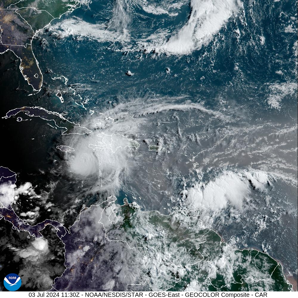
Beryl remains a very powerful hurricane this morning, with 145-mph sustained winds and a central pressure of 952 mb (which is rising, an indication of some slow weakening). It will pass near, or strike the southern edge of Jamaica today, exposing the entire Caribbean island to severe winds, heavy rains, and a large storm surge. This is a reasonable worst-case hurricane for the island, which will be subject to both coastal and inland flooding, in addition to major damage from winds.
Beryl is forecast to weaken as it crosses the Caribbean Sea later this week as it encounters some wind shear, before reaching the Yucatan Peninsula of Mexico on Thursday night or Friday morning. It is likely to be a Category 2 or Category 3 hurricane at this time, although there is some uncertainty in this. As it passes over land, Beryl should weaken further before entering the Gulf of Mexico later on Friday.
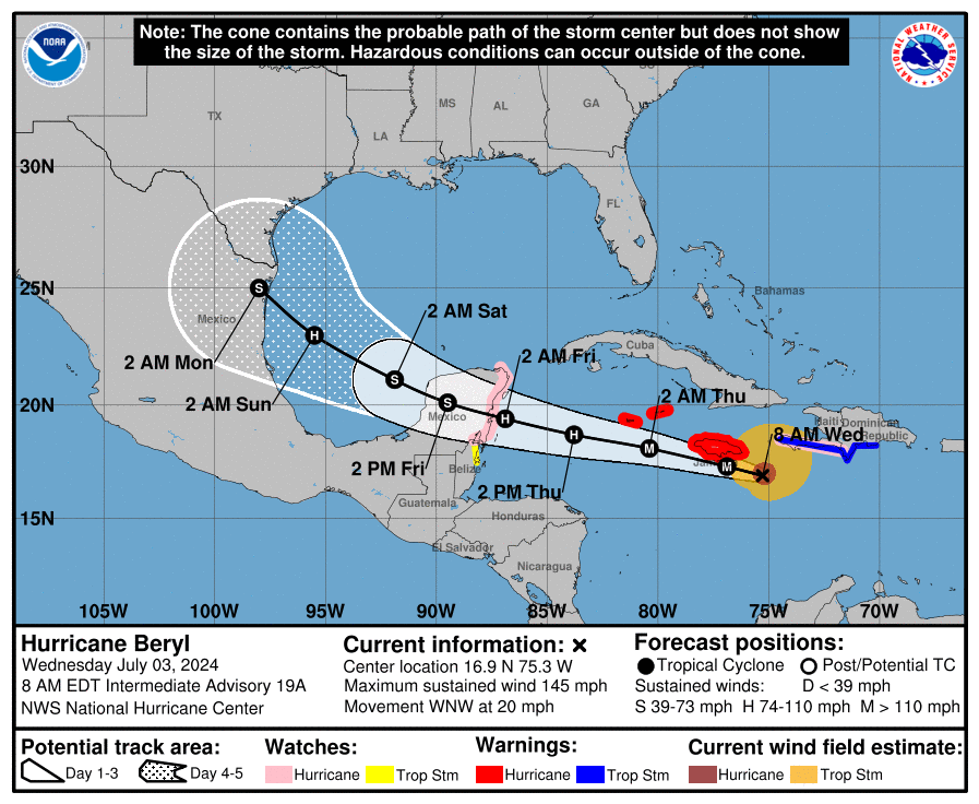
So what happens then? For Texas residents, that is it the big question. And there are a range of possibilities. Based upon my interpretation of the various hurricane models we could see everything from a tropical storm moving inland into the Mexico coast, near Tampico, on Sunday; to a Category 1 or Category 2 hurricane striking Corpus Christi on Monday. In the latter scenario, since Beryl would remain over water longer, it would have more time to re-strengthen over the Gulf of Mexico.
A majority of the hurricane focused models, including HAFS and HMON, favor the “tropical storm into Mexico” scenario, as does the European model and several other solutions. I’m sure a lot of social media attention will be paid to the GFS model this morning, as it brings a hurricane to the Texas coast between Brownsville and Corpus Christi early next week. But for the time being, this looks to be an outlier compared to most of our other guidance.
The official forecast from the National Hurricane Center, which is shown above and will be updated again at 10 am CT, shows a tropical storm/borderline Category 1 hurricane striking the Mexico coast about 50 miles south of Brownsville. I agree with their thinking.
Needless to say, for the upper Texas coast, there would be differing effects from these various scenarios. For Houston, I am not too concerned about winds—for now the worst I’d expect to see is some tropical storm force wind gusts on Sunday or Monday. Seas may get a few feet higher, like they did with Tropical Storm Alberto a couple of weeks ago. But again, for now, I’m not expecting a major storm surge event. The biggest and most widespread impact I expect to see is rainfall.
Beryl should bring some heavy rainfall to parts of Mexico and Texas starting on Sunday, and into next week. The issue is that as the storm crosses the Gulf of Mexico, the high pressure ridge to its north will start to break down, and its steering currents will weaken some. (This is the source of the uncertainty in its track over the Gulf). As a result Beryl may slow down some and have the opportunity to bring heavier rainfall over a couple of days. Please don’t misunderstand me, I am not saying this is another Hurricane Harvey.
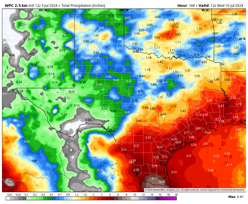
In any case, for Houston, the best chance of rainfall will likely come during the Monday through Wednesday period. My expectation right now is that most of the area receives a manageable 2 to 5 inches of rainfall. But there is some risk of higher totals. I consider this to be a lower probability, but given the influx of tropical moisture into the state of Texas next week we cannot rule out higher bullseyes and the potential for flooding.
I apologize for the lack of concrete answers, but so it goes in tropical forecasting. A good deal of uncertainty remains. At this time my sense is that Beryl goes far enough south to have modest effects on the upper Texas coast, besides increasing rain chances next week. But there remains some risk of more direct and serious effects. We’ll be watching this possibility closely and keep you updated with another post this afternoon. And for information about broader effects across Texas and Mexico, please visit our companion site The Eyewall.

I visited 5-6 popular weather websites, to include NWS. They all agree on the Houston metro extended forecast (we’re in Magnolia) … at least 50% chance of rain every day, Sat (6th) thru Fri (12th). Will mow and fertilize on Fri 👍
Well written, no hysterics, thanks so much!
Thanks for the no hype insights. Love this!
Your anti-hype stance is clearly a plot by big Calm to sell more Less!
We have been bought and sold by BIG CALM.
I’m glad to know that Eric and Matt are bending the knee to the Big Calm overlords.
Everyone needs to simmer down. Just do the usual early prep that you should have done with Alberto: stock your pantry, read your emergency plan and share as needed with family, gas up your car, fill your meds.
Heck, this is almost what you should be doing ALL the time in your normal life.
Agreed. In this case, we are driving to Florida to visit family on Saturday, and have a teenager coming over to feed the cat all week. I’m just trying to gauge what to do with the damn cat, lol.
I’ve noticed over the past many years, if the Saharan dust is bad here the hurricane season seems to be milder. Any (scientific) truth to that or just a odd theory?
Dust absolutely is a contributing factor to weaker seasons.
And we haven’t gotten a big dust plume this year…yikes
Eric … as always, thank you for the no hype, here are the facts, forecast.
The early part of this hurricane season has been tough, and this is supposed to be the “calm” 1/6th of it. Fasten your seat belts. In the words of Karen Carpenter, “We’ve only just begun…..”
I’d like to echo the sentiment…thank you for the no hype forecasts. As a lifelong overthinker, I like knowing I can come here for an outlook that will answer my questions without getting me wound up when I don’t need to be.
Eric- in the models I am seeing another low coming towards Houston right behind Behind Beryl– is that possible model flob? seeing it in the GFS around Wed of next week. I def not hyping anything, I just havent seen a low right after a low…hopefully just brings some rain chances to kill the heat
Reread section Saturday, Sunday, and Beyond.
I was seeing 96L die off as it got close to Yucatan/Western Carribean, but I guess it could ramp back up.
Thanks
Following on in the wake of a more potent storm, in addition to running over land, these systems will often degenerate into more of a tropical wave. That said, they can reintensify once returned to a more storm-friendly environment.
Thanks for the levelheaded advice as always. And for being my go- to place for weather news.
I read this post and the most recent on The Eyewall. Really sorry that you guys are getting hammered by some for your forecasts. Those complaining can go ahead and get ready for hurricane season (which we should be doing anyway) and go to other weather sources that overplay their hand on tropical weather. If they look at the NHC forecast (National Hurricane Center – NOAA’s forecast) they are saying much of what you are saying – that there are a lot of questions remaining in the forecast track. I would rather have common sense prevail vs hype and hysteria.
I am called a weather nurd- I only have 9 weather apps. Your response as usual is spot on. Thanks for the succinct information
Thank you. I always appreciate your down-to-earth analysis.
Thank you for y’all’s level headed realistic reports without the over- dramatization I’ve noticed from at least 2 TV station meteorologists recently (names shall remain unsaid).
Yes! It’s crazy how they like to get people in a panic. I’m not saying things can’t change but some people I have seen posting on social media are sharing these meteorologists and acting like a CAT 5 storm is coming here for sure no questions asked. So bizarre.
Eric, you don’t have to apologize! hurricane predictions are crap shoots up until the last minute. You have no control over it, and apologizing is completely unnecessary.
The scenario that gives us less rainfall will be the most likely based off recent history.
I sincerely appreciate your calming words around the impact of this storm. I’m an over analyzer, and to my ignorant eyes, this storm track reminded me of Harvey.
I was one of the homes that remained underwater for 10 days after Harvey (reservoir release), so that tends to be the “hurricane” type that I freak out most about. Thanks again!!!
Hi “John L”. We too had bad luck with Harvey at our Cypress home. We got 6 foot of water in our home (lost everything) … granted, our home was about 1/2 mile away from Cypress Creek, which got backed up and was the cause. We were about 90% done with rebuilding that home when Harris County stepped in, bought it, and razed it. Along with about 20+ other homes in that neighborhood.
.
But yea, Beryl is tracking the same.
Real people explaining real science. I love this website. Thank you Eric and Matt!
Time to evacuate to Katy. You old timers will remember this. LOL
HaHa Yes!
Sunrise with all that Saharan dust was a thing of beauty! Hopefully, it sticks around.
Thank you for your honest opinion
Thanks to you and Matt for continuing to be the voices of reason among all the noise out there. Please keep up the good work.
Thank you for your no hype forecast!
Thank you for your factual, no-hype weather reporting!
The Gulf is warm dark and deep, Houston got many months , before they sleep, sleep
He gives his laptop, a Dell, a shake
to ask if there is some mistake.
I hope you’re right. Otherwise you’ll be attacked over not hyping it enough, and you’ll lose those 5 readers…who will ultimately come back anyway.
They will always be attacked no matter what they say.
Well, y’all have already got weather forecasts wrong twice in the past couple months (Derecho and last week’s “rain coming from the east”) Let’s see if your wrong with this one.
derechos are difficult to forecast just like predicting an accurate amount of rain an area will receive. Weather forecasting is not gonna be 100% accurate
Whats the foretasted impact on Lake Livingston Dam? TRA has not released any new updates.
I wonder how electric automobiles will perform should we have an actual hurricane evacuation.
Thank Y’all for your N0-Hype Level Headed Forecasts. Haters gonna hate, please ignore them and believe, the vast Majority appreciate your Posts.
Two inches of rain early next week will be good. I haven’t had to water my lawn yet this year.
I’m about to break down and do so for the first time. Sadly.
I love – and support – your work – thank you!! Please, respectfully, why do people keep referencing “Hurricane Harvey”? I thought it was a TS (and a huge shock of one) .. when did it become a Hurricane?
Harvey was a cat 4 hurricane when it made its initial landfall around San Jose Island/Port Aransas. It then weakened to a tropical storm as it moved northward toward Houston, where it stalled and dumped all that rain on the Houston area.