Houston faces a significant rain threat later today and during the overnight hours, and the recent forecast model trends are concerning. I think there are two main threats we must consider: the potential for severe weather, and, separately, very heavy rains.
SEVERE STORMS
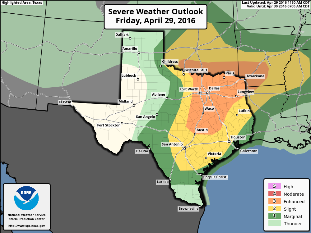
Much of the Houston region falls into the “slight” risk of severe weather for tonight from NOAA’s Storm Prediction Center. I believe this may undersell the risk a little bit.
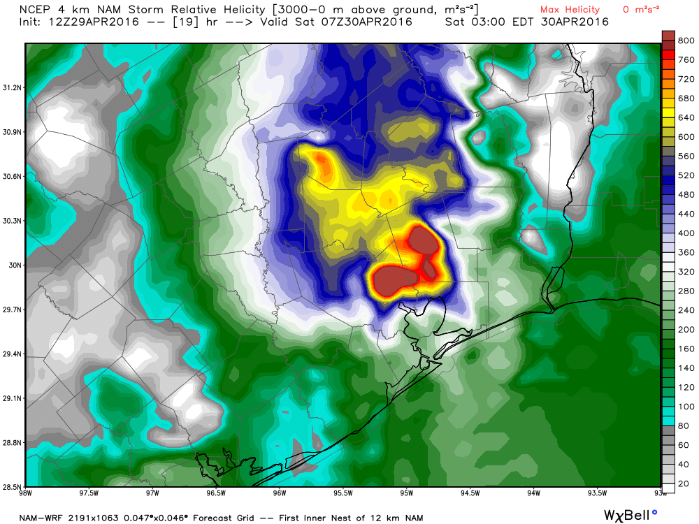
One of the variables forecasters look at when trying to gauge the possibility of severe weather is helicity, which is essentially a measurement of rotation in the upward drafts of a storm system. The greater this value, the higher the threat of tornadoes and damaging winds.
For example, the latest run of the NAM model shows some very high helicity values over much of the northern and northeastern part of the Houston metro area for late tonight. Note that values above 400 allow for the possibility of tornado formation.
For this reason I think we need be at least moderately concerned about the threats of hail, damaging winds and tornadoes from about 4 or 5pm CT today through Saturday morning. The threat is probably highest for northern parts of the metro area, running up to Huntsville. The threat of high winds is doubly concerning given the already wet soils, which will make it easier for any strong winds to knock down trees with shallow roots of power poles.
HEAVY RAINS
The other primary threat, of course, is heavy rain. The forecast models remain all over the place, but some of the better mesoscale models are showing the potential for very heavy rainfall tonight.
With ample moisture it is possible we will see rainfall rates in excess of 2 inches per hour, and this could lead to high rainfall totals where storms stall. Matt and I have discussed this, and believe it’s reasonable to expect that some parts of the greater Houston metro region may see rain bullseyes of 5 to 10 inches between later this afternoon and Saturday morning. If this occurs over the wrong part of town, such as western or northwestern Harris County, we could see significant flooding once again.
I am not guaranteeing this. There’s too much uncertainty for that. But we can confidently say there is the potential for a major rainstorm across the Houston area during the next 24 hours, with widespread rain accumulations of 2 to 5 inches, and more locally. Perhaps quite a bit more.
Stay tuned to us here, as we’ll keep you as updated as possible.
Posted at 2:25pm CT Friday
Changed your mind on Meyerland yet? This stress is overwhelming – we just about have our house dried out from last week.
Yes. The outlook is much better now for you (and the rest of Houston).
What is/are the catalysts for these storms?
Lots of moisture flowing in from the Gulf of Mexico (and I do mean a lot) combined with an upper-level atmosphere that supports rising air.
What time is the next update? Any guess on rain totals for Pearland and Friendswood?
Just posted it. At this point I’d go 1-4 inches, but not until Saturday morning.
Thank you Eric and Matt, as always. What would we do without your expertise, and more importantly your willingness to share it!
Thank you for the best understanding of Houston weather out there!
Dear Eric. VERY IMPORTANT!
I live in Southwest Houston, in the 77077 zipcode area. That is just south of I-10. You have just said that threat of hail, damaging winds and tornadoes from about 4 or 5pm CT today through Saturday morning is probably highest for northern parts of the metro area, running up to Huntsville. You have also said that the threat of high winds is doubly concerning given the already wet soils, which will make it easier for any strong winds to knock down trees with shallow roots of power poles. The question then becomes, this:
Do I, in Southwest Houston, stand a better (that’s with a capital B) chance of keeping my power than people in the areas of the metro you just mentioned?
The risk of power outages is lower in areas where the chance of storms is lower. In any case, I’d say you’re good to go until at least early Saturday morning.
18UTC run of the NAM doesn’t exactly show what you’re talking about, Eric. You must be referring to an earlier run.
You’re right. That was based on the 12z NAM and some of the afternoon HRRR model runs. Those models clearly poorly initialized the shower activity (or rather lack thereof). I’ve since posted an updated forecast.