Good morning. As Matt wrote last night, there’s more rain to come for Houston during the next few days, and an already waterlogged region faces still more flooding. It is not a happy situation.
As we’ve expected, upper-level low pressure is combining with a strong southwesterly flow to drive showers and thunderstorms this morning. During the pre-dawn hours this produced an additional 1 inch of rain along Spring Creek, generally in northern Harris and southern Montgomery counties, which had already received as much as 6 inches on Wednesday evening. Both Spring Creek and Cypress Creek, in the area, are near bankfull. The West Fork of the San Jacinto River has returned to major flood levels. And southwest of Houston, of course, the Brazos River remains at historically high flood levels (it crested at 54.78 feet last night).
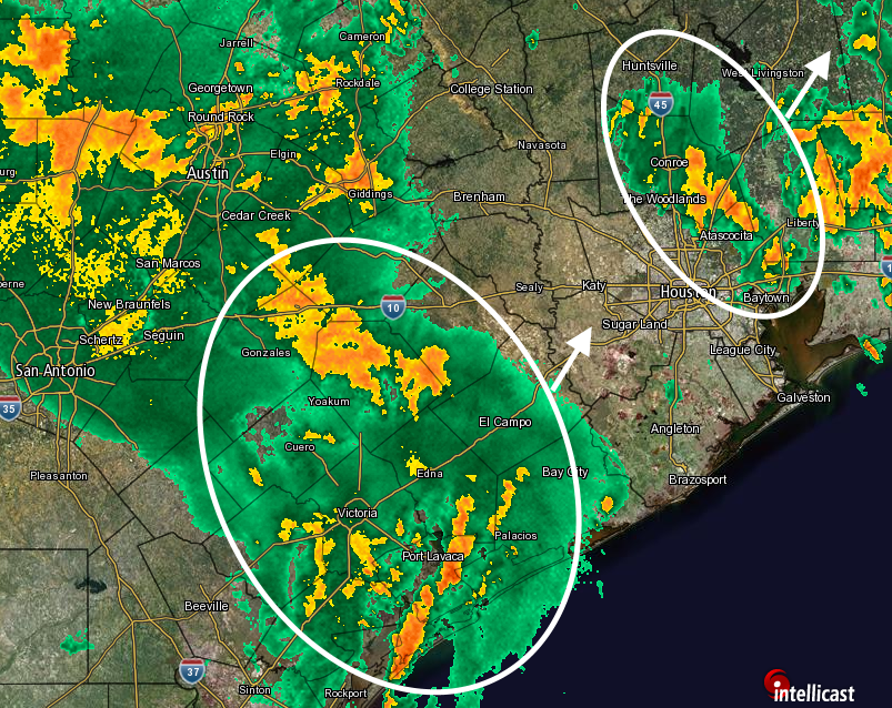
Given the conditions of ample moisture and atmospheric lift, along with potentially slow storm motions and backbuilding, there is good reason to believe the area will see an additional 2 to 5 inches of rain for the rest of today through Saturday, with isolated areas seeing as much as 8 to 10 inches. The two big issues with this are as follows:
- The Brazos River, Spring Creek, Cypress Creek and San Jacinto River basins cannot handle any more heavy rains. Any additional rainfall will further overwhelm these basins and exacerbate the flooding situation to nearby neighborhoods.
- As we have seen already this spring, a moist atmosphere and this kind of lift is capable of producing rainfall rates of 2-3 inches per hours, which is enough to overwhelm the ability of any streets and bayous to carry the water away. Even roads that haven’t flooded yet could flood with these kinds of rain rates.
Add it all up and the region faces a dangerous flooding situation: both from sustained flooding of homes near swollen waterways, and quickly rising waters due to excessive rainfall rates. A flash flood watch is in effect for the entire Houston metro area through 7pm CT Friday, and it may well be extended.
It is important to be cognizant of these potentially hazardous weather conditions today, Friday and Saturday, and to take care when traveling around the Houston area. Most importantly, do not drive into high water. You will feel the urge to see if you can “make it.” In some cases you will make it, certainly. But in some you won’t, and in the best case you’ll just lose your vehicle. In the worst case you’ll lose your life.
It appears that the chances for heavy rain will begin to slacken later on Saturday or Sunday, with warmer days in the upper 80s to 90 degrees by Monday or so, with only a chance of scattered afternoon thunderstorms.
Posted at 6:35am CT Thursday by Eric Berger
Eric and Matt, once again I say thank you so much for providing us this hype-free picture of the weather. I guess that’s my role in this crazy rain version of “Groundhog Day”.
Go to weather.com for houston, zoom out the map to show all texas then animate it for a good example of rotation around the low pressure area.
Just a suggestion to alleviate some of the server load. Can you have the email summary send out the entire blog post rather than making users click for more. That way the email has all the relevant info.
Yes, a good suggestion, thank you.
Any chance we could get Rick Perry to pray for the rain to end?
Thanks guys. These posts are a sense of comfort during these rain-drenched times. I appreciate the real “look aheads” and multiple-per-day updates, all local!
Do you think I should cancel my lunch in Beaumont today?
I’d consider it. I think the heaviest rains will be between Houston and Beaumont later this morning.
Thanks – it’s not a critical meeting. I’m leery about the 1-10 bridge over the San Jac River on my way home later today…
I was planning on heading to Austin today ( in an hour or so) and coming back Saturday. Bad or good idea?
Probably an OK idea, especially if you leave Houston in an hour as you say.