In brief: Ironically, Thursday was “National Love a Tree Day.” Instead of loving trees, however, a line of storms ripped through the heart of Houston and tore many thousands of them down, killing a handful of people, damaging homes and vehicles, and bringing down power lines. In this post we’ll provide some meteorological data about what happened Thursday, and a forecast looking ahead to calmer weather.
Tornadoes
The National Weather Service has completed a survey of damage from two confirmed tornadoes that struck Houston on Thursday evening, one at 5:44 pm near Pine Island in Waller County, and the second at 6:08 pm near Jersey Village in Harris County. Here is the summary of those investigations:
Waller County tornado
- Rated EF1
- Peak winds: 100 mph
- Path length: 0.71 miles
- Path width: 100 yards
- No fatalities or injuries
- Duration: 5:44 to 5:45 pm CT
- Significant tree damage, large metal barn destroyed, metal debris thrown up to 1,000 yards away.
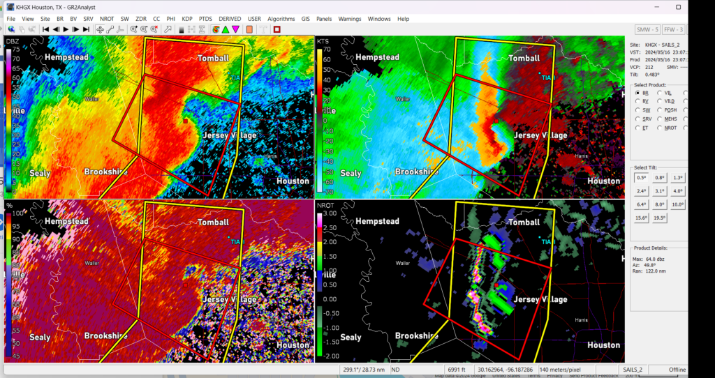
Cypress tornado
- Rated EF1
- Peak winds: 110 mph
- Path length: 0.77 miles
- Path width: 100 yards
- No fatalities or injuries
- Duration: 6:08 to 6:09 pm CT
- Numerous single family homes had roof damage and broken windows. Damage path well defined.
This is a preliminary report that may be adjusted in the future.
Straight-line wind damage
As Matt noted yesterday, most of the damage in the region was caused by straight-line winds, and what appeared to be something of a mini-derecho. The National Weather Service has also collected maximum wind reports from around the area on Thursday afternoon and evening. Some of the highest values were recorded at Texas A&M University, 71 mph, and the Houston Ship Channel, 74 mph.
Very strong winds just above the surface were able to break through, and get down to the ground. These winds a few hundred feet above the ground were even stronger than what was observed at ground level. This is likely the reason why some skyscrapers in downtown Houston observed significant damage at their upper levels.
Power outages
About one-quarter of customers in Harris County are still without electricity this morning. In an update to the media on Friday evening, CenterPoint Energy said restoration could take “several days or longer” for the hardest hit areas.
“As crews continue to uncover damage and encounter new challenges while making repairs, restoration may take more time than customers typically experience following a routine storm event,” the company said. “CenterPoint Energy appreciates customers’ patience, and the company will work around-the-clock until the last customer is restored.”
We genuinely appreciate the hard work by all of the lineman working to restore power. It is a hard and hot business to rapidly repair storm damage, I know first-hand how hard the men and women are working out there.
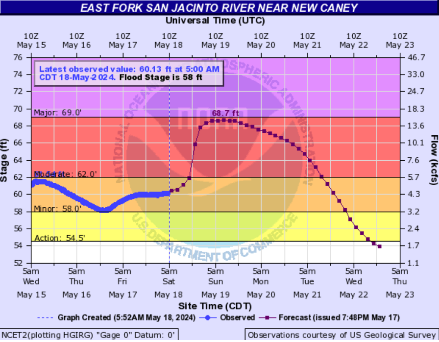
Flooding
The heaviest rainfall on Thursday occurred north of the area, in locations such as College Station and Livingston, which have already been inundated over the last 30 days. Significant river flooding is likely along the East Fork of the San Jacinto River later this weekend, whereas the Trinity River is already cresting today before a slow fall next week.
Fortunately the entire southeast Texas region will now get a chance to dry out. Our weather is about to get boring.
Forecast
After the fog lifts this morning we’ll see sunny and hot conditions today, with highs likely in the low 90s. And that’s pretty much your forecast for the next week, at least. The only change will be gradually warming nights. Lows this morning got to below 70 degrees for most locations. It was, almost, nice? Well, except for the mosquitoes. By Wednesday or Thursday morning, our lows are likely to only dip into the upper 70s. Rain chances are nil for the foreseeable future.
We wish everyone the best this weekend as you recover from Thursday’s storms, and thank everyone who is out there helping to pick up the pieces. This community is at its best in moments like these, when we’re all working together.

This level of power outage does not bode well for Hurricane season! Imagine if a Cat 3 or 4 roared into town…even a Cat 2.
not hard to imagine if you lived here during Ike.
….except for the mosquitos. Yes. Not helping anything.
These generators are the worst. Old homes in the Heights do not need this constant vibration. Time to move out of here u til power is restored….otherwise it would be tolerable.
Thank you for your consistent excellence in keeping us informed on our crazy weather in our strange hot city.
I remember sustained winds in Ike that were around 85. I’m in the same house and I feel like I got gusts in this storm higher than that for short periods. I could feel wind coming in at the baseboards. Yet the high winds report says 74 at Ship Channel. Will more wind reports be coming in?
We live just past N edge of Jersey Village and the mosquitoes are HORRIBLE… after 14 years here I’ve never seen it so insanely bad. Thanks for the great reporting!!!
We need underground power lines.
Nothing has changed around here for decades except develop more but blow off infrastructure improvements.
exactly yet the city is taking them out from the ground and putting them on poles lol because it’s ‘cheaper and more convenient’…
Supposedly it costs $30 million per mile to bury existing lines underground in cities. Even if it was significantly less there’s no way Houston could afford it.
https://www.khou.com/article/money/powerlines-underground-money-the-why/285-a44b614c-47c5-493c-a2c9-c08dffcfc6e5
According to the Edison Electric Institute “moving power lines underground would cost $1.4 million per mile in rural areas and $30 million per mile in cities”.
We probably couldn’t afford it if it cost a double meat Whataburger per mile.
One good thing about Clear Lake – the power lines in the neighborhoods are underground.
Burying power lines in a city that floods often and where the water table is so close to the surface is both expensive and counterproductive at this point. In addition, corrosive saltwater is beginning to penetrate the aquifers in some areas. A better, and much less expensive, solution is to harden the grid to the extent we can and then keep it maintained. In terms of frequency, flooding is a bigger problem for us than high winds.
we need more rain at the end of the month
I don’t think you’ll get many supporters on that statement at the moment….
I’d like to show some love to the businesses that were open Friday morning, in particular Queen Donut on 18th in Timbergrove/Lazybrook. Driving through that area made it clear how bad they got hit and the looks on peoples’ faces in line told the story from the night before. A little bit of normalcy in the form of a kolache went a long way. Thank you, Queen Donut!
Eventually we’ll migrate to thorium and it will be old infrastructure
If that wasn’t a tornado that came through Timbergrove, that’s about as close to one as I ever care to get!
Thanks for the updates. Does Centerpoint have an idea of what areas they’re trying to get powered up first? Obviously, they need the transmission towers back up but I have to assume the lineman working that project is different from the ones inside the neighborhoods. Heights, Spring Branch, Parts of Memorial and those along 290. Is there any indication on timing?
You guys are doing great work! While a lot of weather sources “simplify” (dumb down?) information, you actually explain things — clearly and completely. It’s appreciated.
I would like to thank ya’ll for helping me get through weather situations such as we had on Thursday. I always know I’m getting the best and most accurate information. May God bless all of you.
💗 SCW 💗
You might tell your friends at Centerpoint that their old outage tracker was better, faster, more reliable, and easier to get information on a phone even when data was slow due to congestion. On the other hand, the new tracker, is bloated, slow, unreliable, and impossible to use on a phone when data is slow due to congestion. I notice that the new tracker hasn’t been working at all for a while.
That’s because they are using Microsoft server software, and no doubt it’s operating system. Proven as inferior to other options.
“Love a tree day?” There is a time in the place for everything and I think you got both wrong with this joke. Especially considering the failure of the meteorological community as a whole. Perhaps a little bit of introspection on the part that community played in the loss of life that occurred as a result of this weather.
They call them predictions for a reason….sometimes predictions are wrong even when you have a lot of infor
I cannot believe people are trying to hold meteorologists responsible for what was essentially an act of God. I understand that when terrible things happen, we want someone to blame. But sometimes there is no one to blame. No meteorologist is responsible for any of the deaths that occurred, and that is honestly horrible of you to suggest such a thing. Read up a little on derecho events like this one; they can occur very suddenly without warning. As it is, the guys here at SCW and other meteorologists in the area warned of the possibility of severe weather on Thursday. The problem is, a lot of people shrug that off. I have heard people say they got the tornado warning on Thursday and thought nothing of it. That is not the meteorologists’ fault.
People need to water their trees when we have extreme dry weather. So many residents ignore trees while watering lawns. Trees need soaking in drought.