Storms continue for much of the Houston metro region this morning, as a line of showers sags slowly into central and southeastern parts of the city. But overall we’re not seeing a whole lot of movement as a major line of storms set up along the I-10 corridor to the west of Houston.
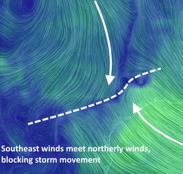
This is largely due to a convergence of winds coming down from the north and meeting with more winds coming off the Gulf of Mexico. This does two things: Convergence at the surface leads to rising air, a key ingredient of thunderstorms, and it is not allowing the storms to move much. Here’s what this looks like in terms of surface winds.

The natural question is what comes next? These boundaries aren’t really going anywhere, and neither is the moisture. And our outlook for the rest of the day and tonight depends on what happens with the storm activity over much of Houston now. So here are a couple of scenarios I can envision.
Scenario 1
The heavy storms over much of the Houston area continue to move east, with a core slowly sagging to the southeast. However continual redevelopment to the west of Houston keeps this convection going through the morning and at least early afternoon hours. Eventually the atmosphere burns itself out to some extent, leading to a respite in storms tonight.
Scenario 2
We see a gradual diminishment in shower activity to the west of Houston, and the current activity sags to the southeast, pushing into Galveston Bay and beyond by around noon. However this midday respite in activity over Houston allows for the atmosphere to recharge, and we see another major line of showers and thunderstorms move across the region later this afternoon and evening.
As you can see, in either scenario, Houston gets multiple inches more of rain today or tonight. Overall, however, I think there’s a reasonable chance in either scenario that we might see a break from the heaviest rain by Tuesday morning.
The bottom line is this: Major flooding is occurring to the west of Houston, and as the heavy rains move into central parts of the city we are seeing bayous there near bankfull (here’s some pretty incredible video footage of Brays Bayou). There’s the potential for additional widespread flooding today so do not go outdoors unless it is absolutely necessary.
The storms have died down for the first time since 4 AM, just light rain right now (BW 8 on the west side). I know there is more coming, but I’m thankful for the pause. Also very thankful for the updates and information that you’re giving us!
I got to work on the Ship Channel only 15 minutes late, but after 30 minutes in the office and with half our day staff here, we get a call from our Emergency Notification System telling us to work from home today. Nothing like good communications. Arrrgh!
Not terribly bad on the Ship Channel now – – moderate rain with some lightning.
Good information and breakdown of the scenarios, Eric. Thanks as always.
Thanks guys, your work is much appreciated!
Excellent update as usual. I live near the Sugar Land airport and was unable to leave my neighborhood at 6:30 this a.m. Never seen the streets this high. The last time it was almost this bad was Alicia.
Props for calling this almost a week ago.
Thanks!
I’m in Austin right now and was originally going to come back to Houston late this afternoon. Now wondering if I should wait until tomorrow, or will it be just as bad or worse tomorrow?
I think you’ll be OK if you try to go later this afternoon.
League City gonna see some heavy rains at some point? Inches?
League City is one of the few areas that probably is not going to see too much action from this storm system.
Thanks for the hype-free breakdowns. I appreciate them!
You might want to consider dating these entries so we know which “tonight” you’re referring to.
Thanks. I try to remember to time stamp them at the bottom of the post. (I don’t always remember tho!)