Just an incredible evening of heavy rain north and northwest of the city of Houston, with 6 to 8 inches of rain falling across much of western Montgomery County, and 8 to 14 inches coming down over an area from Brenham to Montgomery. Many roads are impassable, including some locations of Highway 290 northwest of Harris County.
The National Weather Service has issued a Flash Flood Emergency for Washington and northern Austin Counties tonight due to extremely heavy rains in those areas. This is the highest level of flood warning. Multiple high water rescues have occurred in these areas.
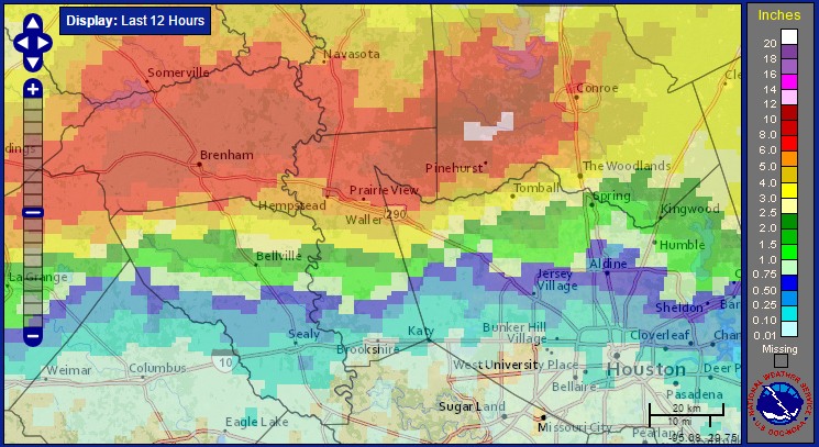
Unfortunately storms are continuing to develop along a west-to-east boundary north of Interstate 10 tonight, and I think we’ll see continued development of storms for the next few hours. A flash flood warning is in effect for pretty much all of the northern half of the Houston metro area until at least 2:45am CT. Some homes along Spring Creek, in southern Montgomery and northern Harris County, have already flooded as the creek has risen several feet out of its banks.
The forecast is far from clear, but I think we’ll see additional storms move in from west during the overnight hours, with more widespread showers moving into the central and southern Houston metro area by, or around sunrise on Friday morning. I’m hopeful the heaviest rains will exist the region by mid-morning, or noon at the latest, but the entire Houston metro is under a flash flood watch through at least 7pm CT on Friday.
Posted by Eric Berger at 11:05pm CT on Thursday
What about IAH tomorrow morning? What should we expect?
Possible delays. There were some this evening and the airport was well south of the worst of it.