Warmer, muggy weather to persist through the weekend for Houston

Some coastal areas are seeing fog this morning as warmer air moves over the cooler Gulf waters. Such a pattern could continue during the morning hours through Monday. For the rest of the region, it will just be anomalously warm.

Today

Skies should be partly to mostly sunny today, allowing high temperatures to climb to about 80 degrees. There is only a slight chance of showers this afternoon.

A front is moving into Texas this morning but will stall before reaching Houston. (Weather Bell)

Friday and Saturday

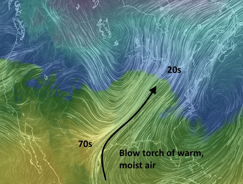
Although a very strong cold front is moving into west Texas this morning, its effects are unlikely to reach all the way to the Houston area after it stalls tonight (College Station might see some cooler air). Therefore Houston is likely to see a couple of partly to mostly cloudy days on Friday and Saturday, with highs in the mid-70s, and warm nights. Some light rain showers are possible.

(Space City Weather is sponsored by Westbury Christian School for this month)

See full post

After record warmth, heavy rain possible late this weekend in Houston

It’s a warm morning across the region, with lows generally in the mid- to upper-60s across the region. This is more than 20 degrees above normal for January, and this near-record warmth is going to be more or less what we get through Sunday.

Today and Thursday

We’ll continue to see brisk southerly and southeasterly winds, which will bring very warm and moist air into the region. Highs should reach as high as 80 degrees across parts of Houston, and record high temperatures especially today (81 degrees at Bush IAH, 80 degrees Hobby, 75 degrees Galveston) are within reach. Skies will range from partly to mostly cloudy. Lows may not fall below 70 degrees for some areas between downtown Houston and the coast, and fog may become an issue during the early morning hours.

Friday and Saturday

After a cold front stalls across north Texas on Friday, so this won’t modify our weather’s region much. However winds should die down a little bit, and as moisture continues to accumulate in the atmosphere from the onshore flow we’re going to see some chances for scattered, light rain—but I would expect anything too heavy. Highs will be in the mid-70s for most of Houston, with lows in the mid-60s.

(Space City Weather is sponsored by Westbury Christian School for this month)

See full post

Record high temperatures possible this week in Houston

Good morning. Any vestiges of last weekend’s Arctic blast have fled from Houston now, retreating from a warm and moist southerly winds blowing into the region from The Gulf of Mexico and the country itself. The pronounced flow will make for warm temperatures for much of the United States.

A strong southerly jet of wind is bringing warmth and moisture into the United States. (earth.nullschool.net)

Today

Expect a breezy day as southerly winds gust into the low 20s. Skies should be partly to mostly cloudy as high temperatures climb into the upper 70s. Expect lows tonight to fall only into the mid-60s.

Wednesday and Thursday

Not really sure what to say about these days other than … WTF?!? We’ll get another couple of very winds (20-25mph gusts) days, with partly sunny skies and high temperatures of around 80 degrees. Did I mention that this is typically the coldest time of year? The record high for both days is 81 degrees, and we’ll have to watch and see if those are broken. Overnight lows will probably remain in the upper 60s.

Friday and Saturday

A cold front will enter Texas on Friday but stall north of the Houston region. Along with more favorable dynamics in the upper atmosphere, this should lead to at least some scattered rain chances on both days, and we can’t rule out some thunderstorms. With the possibility of some rain and the return of some clouds, expect highs to moderate slightly, perhaps into the mid-70s.

(Space City Weather is sponsored by Westbury Christian School for this month)

See full post

Houston this week: From the icebox back into the swamp

After the region’s coldest weather in four years temperatures in Houston will now rapidly swing upward. Within a couple of days average temperatures will rise about 40 degrees higher than they were this past weekend, a remarkable swing. By late week overnight lows should be about 25 degrees warmer than normal.

Today

Winds have already shifted from the north to the southeast, and correspondingly humidity levels have begun to rise. From lows around 50 degrees this morning, temperatures will climb to the mid-60s later today under cloudy skies, with a slight chance of rain. Lows tonight will only fall into the low 60s—in other words, almost not at all.

Tuesday

A gusty day as onshore winds continue to blow inland. Scattered rain chances on Tuesday morning will give way to a mostly cloudy, very warm day, with highs in the upper 70s.

Wednesday and Thursday

The region’s warmth continues, with partly sunny days, highs in the upper 70s (perhaps even touching 80 degrees in a few areas), and very warm nights in the mid- to upper 60s. Last Saturday’s average temperature—the average of the day’s high and low—was just 32 degrees. I expect the average temperature toward the end of the week to be in the low 70s for most Houston.

(Space City Weather is sponsored by Westbury Christian School for this month)

See full post