Houston now warmer, a little wetter, until Saturday morning

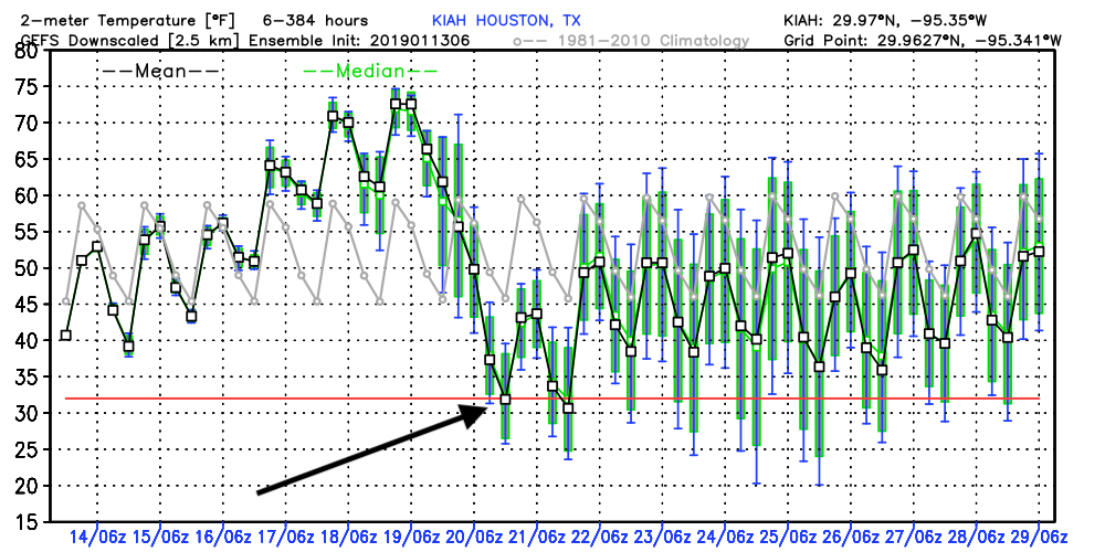
After a few days during which highs failed to get out of the 50s for most of Houston, our region’s weather pattern will now turn warmer for the next few days. We’ll see on-and-off rain chances through Saturday morning, by which time a strong Arctic front will sweep through the area. Forecast models have backed off with some of the more extreme cold, but much of the area should still see a light freeze.

Wednesday

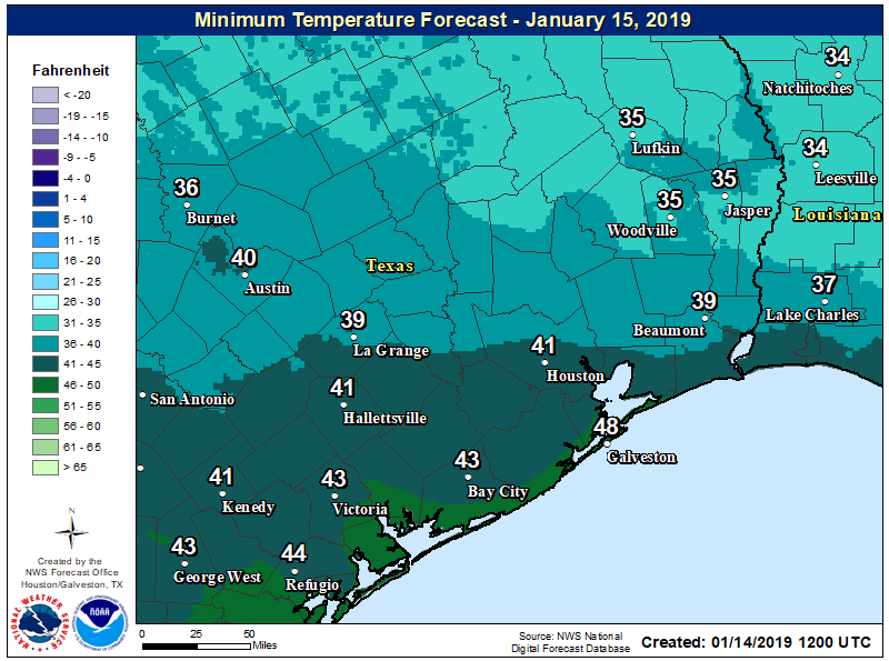
Winds will shift to come from the south this morning, and this will initiate a period of rising moisture levels and temperatures. Light rain showers will be possible today, with better coverage—perhaps 50 percent—likely closer to the coast. Accumulations won’t be above a few tenths of an inch. Highs should get into the low 60s, and lows tonight won’t fall much below that. Rain chances will continue overnight, with the better rain possibilities again near the coast where moisture levels are highest.

Lows Wednesday night will be in the 50s for most of Houston. (National Weather Service)

Thursday

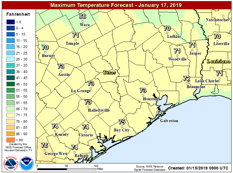
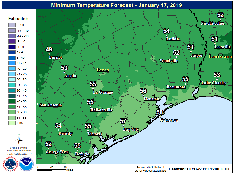
Cloudy skies will continue, but in terms of rainfall this should be a mostly dry day with only isolated to scattered showers after sunrise. Expect highs in the low 70s as warm air really starts to move in from the south and southwest. Lows Thursday night probably won’t fall much below 60 for most of Houston.

See full post

The sun will now disappear from the sky for awhile

Well, the sunshine was nice while it lasted. But now we’re returning to a period of mostly cloudy weather for the next several days, and we probably won’t see much sustained sunshine until Sunday or so. After today we’ll also see a warming trend through Friday before the season’s strongest Arctic front to date roars through the area.

Tuesday

Temperatures are starting out in the 40s for most of the region, and due to thickening clouds they’re unlikely to rise much past the mid-50s. However, winds will be fairly light, from the east, so overall today should be a fairly mild winter day. Lows tonight will only drop a few degrees from daytime highs as a warmer, moister southerly flow begins later today.

Highs by Thursday will be positively spring like for Houston. (National Weather Service)

Wednesday, Thursday, and Friday

We’ll see continued mostly gray conditions for the second half of the work week, as well as rising temperatures and rain chances. Highs will transition from the 60s on Wednesday into the 70s on Thursday and Friday. Lows probably won’t fall much below 60, if at all, due to the persistent cloud deck. Rising moisture levels will mean the return of on-again, off-again light to moderate rain chances. While we can’t rule out a few thunderstorms, generally we expect moderate accumulations through Friday, with only a few tenths of an inch of rain for most.

See full post

A mild week before an Arctic front crashes into Houston

Houston is experiencing a chilly morning, with lows generally ranging from the upper-30s to lower-40s across the region. This is cold for Houston, but as we’ll see in the forecast, it’s going to get colder still by next weekend as an Arctic front storms into Houston on Saturday.

Monday

The region enjoyed a mostly sunny weekend, and we should have more sunshine today before the clouds begin rolling in tonight and Tuesday. Expect dry and cool conditions today, with highs in the mid-50s and only mild winds. We’ll see another cold night on Monday night, although some scattered clouds should keep temperatures a couple of degrees warmer than Sunday night and Monday morning.

Monday night will be another chilly one before temperatures warm this week. (National Weather Service)

Tuesday

With a more southeasterly flow in place, skies should become more cloudy as moisture levels rise. Expect high temperatures near 60 degrees, with overnight lows around 50 in the city.

Wednesday, Thursday, and Friday

Temperatures should warm from the mid-60s on Wednesday to the lower- or mid-70s on Friday, and rising moisture levels may lead to some scattered light to moderate rain showers. I would not anticipate anything more than a few tenths of an inch of rain. Overnight lows will climb to around 60 degrees, but this warm-up should be fairly brief because …

See full post

The 2019 Houston Marathon will be cold, or very cold

For about a week now, when looking at the weather for Sunday, Jan. 20, we’ve discussed the timing and strength of a front expected to come through Houston just before or during the Houston Marathon weekend. There is now fairly high confidence the front will make it through on Saturday, and the front appears to be strong. The key questions we have now are rainfall/snow (unlikely, but impossible to rule out) and winds (a potential concern).

Assuming the front pushes through the region on Saturday, the most likely scenario is a clearing out of skies sometime Saturday night or Sunday. Under such a scenario, the region would see ideal cooling for Sunday morning. Right now, there is about a 90 percent chance the temperature on Sunday morning will fall below 40 degrees, and at least a 50 percent chance it falls to 35 degrees or below. Sub-freezing temperatures are certainly possible.

GFS ensemble forecast for temps in Houston. Arrow denotes range for Sunday, Jan. 20. (Weather Bell)

With no precipitation the most likely outcome on Sunday morning, the biggest concern I have is winds. These will of course depend on the timing of the frontal passage (an earlier front would give them time to die down), and other factors including pressure gradient. I think it is possible that we see anything from 5mph northerly winds up to 25mph (with higher gusts). It is impossible to forecast winds this far out, but I think there is a reasonable chance we see sustained winds in the 15-20 mph range in the wake of the front, which would produce wind chills down to around 20 degrees at the start of the race. Brrrr.

Bear in mind we are still a week away from the race, and there is always uncertainty in seven-day forecasts. But confidence right now is pretty high in a cold race day, with a potentially quite cold day given the possibility of winds.