Lots of sunshine ahead in Houston’s forecast

It’s been a somewhat dreary winter so far, but we’re now entering a period in which high pressure may dominate our weather more—not all the time, to be sure—and this should bring us a nice string of mostly sunny days. If you like cooler, sunny weather, the coming forecast period should be perfect for you. Also, the weather for the Houston Marathon looks increasingly likely to be cold.

Friday

After a cool start in the 40s for most of Houston, the region should warm into the mid-60s today under mostly sunny skies. It should be a pleasant day before a cold front approaches from the west and pushes through the area. Lows tonight will be in the 50s for the most part.

Rain accumulations for most of Houston tonight should be less than one-half inch. (National Weather Service)

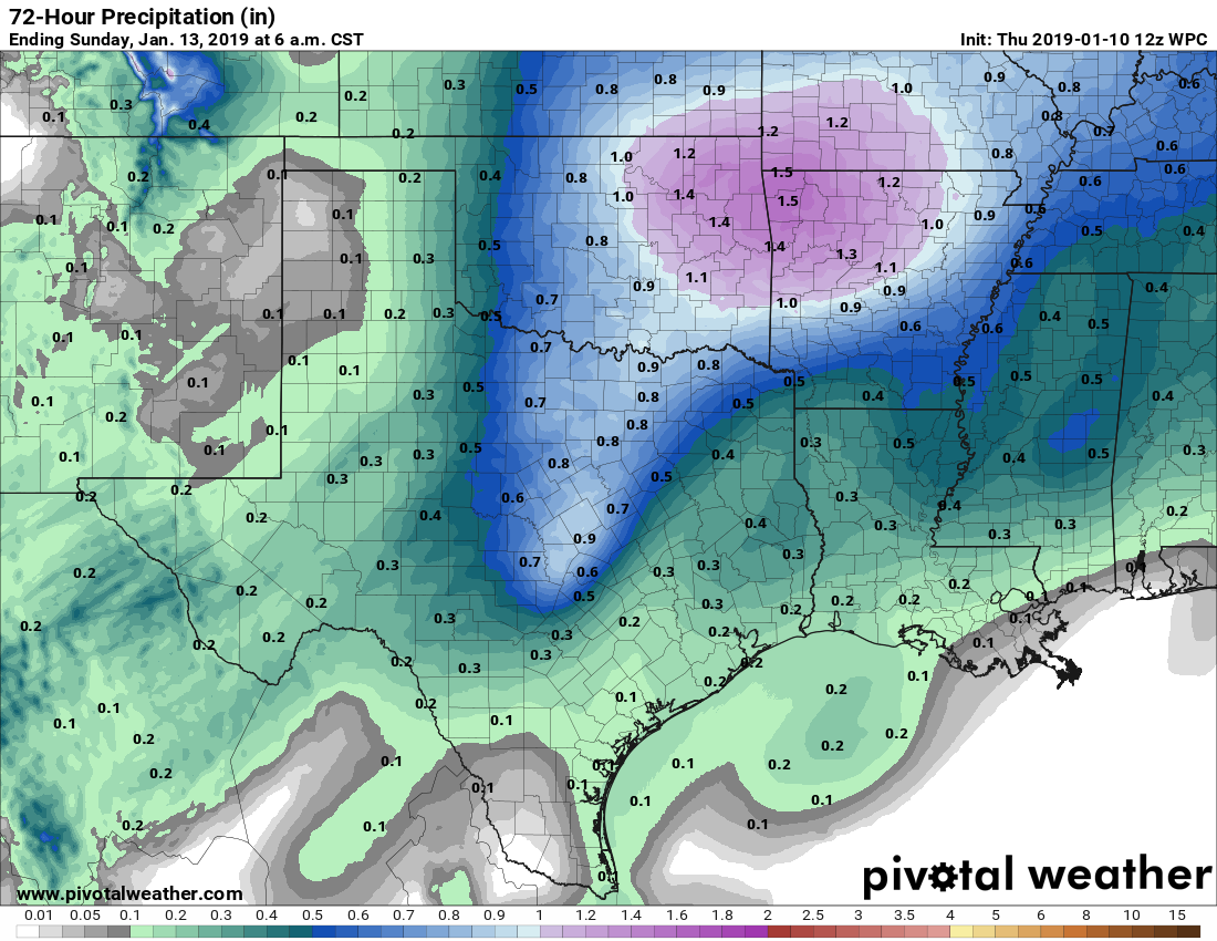
In terms of rainfall, some scattered showers are possible this evening, and then a line of broken showers and thunderstorms will develop later, likely pushing through Houston from west to east between 10 or 11pm Friday night and sunrise on Saturday. We still expect most areas to see one-half inch of rain, or less from this system, but there could be some higher isolated totals. We don’t anticipate any problems from the rain.

Saturday

Rains should end around sunrise, or shortly thereafter, and the remnant clouds should dissipate by around midday if not before. Highs will reach into the mid- to upper-60s under sunny skies, with drier and eventually cooler air blowing in from the northwest. Saturday night will be chilly, with lows dropping down to around 40 degrees in the city of Houston, and upper 30s for inland areas, most likely.

See full post

Houston’s weather will be cooler for several days now

It’s chilly this morning, with lows in the 30s for areas well inland, such as the northern half of Montgomery County, and generally the low 40s for most of Houston. We will now remain on the cooler side of things until the middle of next week.

Thursday

Temperatures today will depend upon the extent of cloud cover at your location, but generally we should see partly sunny skies, and this should allow highs to reach about 60 degrees. As winds shift to the east, and a few more clouds develop Thursday night, we lows will likely be about five degrees warmer at your location on Friday morning.

Friday

And upper level storm system, with a cold front at the surface, will move into Texas on Friday, and bring a healthy chance of rain to the region Friday evening and during the overnight hours. During the daytime, however, we should mostly see clouds, and highs in the mid-60s. As for accumulations, the better dynamics for heavy rainfall are to the north of Houston, so I expect most in the city to only see a few tenths of an inch of rain, with a few pockets of higher totals near 1 inch. Lows Friday night will be in the 50s.

Higher rain totals this Friday should be north of Houston. (Pivotal Weather)

Saturday

Scattered showers should clear out of the area by or before noon, with sunny skies filling in. Highs will reach the upper 60s before cooler, northern air moves in later in the day. Overnight lows Saturday will be chilly, with northern parts of the metro area likely falling into the 30s, while most of the city remains near 40 degrees.

See full post

Mostly sedate weather for Houston for awhile

In the wake of Tuesday evening’s front, it’s a fairly quiet forecast for Houston over the next several days with no real extreme weather ahead—just some sunshine, a little bit of rain, and mostly cooler but not particularly cold temperatures over the next seven days. We’re also continuing to track the forecast for Houston Marathon, which has the potential to be pretty great, but also a steamy mess.

Wednesday

With high pressure moving into place over Houston, we’ll see a pleasant day, with mostly sunny skies and high temperatures in the mid-60s. Light northeasterly winds will be bringing additional dry air into the region today, and with partly cloudy skies tonight we should see temperatures drop down to near 40 degrees in most of the city.

Thursday morning will be a cold one for southeast Texas. (National Weather Service)

Thursday

Winds will shift to come from the east on Thursday, and the mixing in of some clouds should help to limit high temperatures to about 60 degrees. This will probably be a day when you want a light jacket. Overnight temperatures Thursday will be a bit warmer, with mostly cloudy skies keeping most of the region in the mid- to upper-40s.

See full post

One last day of “spring” before more winter-like weather returns

Good morning. Today’s likely our last day as warm as the mid-70s for quite some time, as we should see a couple of fronts over the next week that will limit our high temperatures. We’re not going to see any temperatures too cold either, so there should be no concerns about freezes.

Tuesday

The warmer temperatures this morning—upper 50s to low 60s across most of the region—are contributing to the development of some fog over inland areas. This should clear before 9am. Partly sunny skies should help temperatures reach the mid- or even upper-70s this afternoon before a cold front pushes through the region later this afternoon and early evening.

Warm weather for one more day in Houston. (National Weather Service)

This is likely to be a dry frontal passage due to a capping inversion, or warmer air aloft that limits the ability of air at the surface to rise. Cooler and drier air will follow the front, with lows tonight in the low 50s for most of Houston.

Wednesday and Thursday

Winter-like temperatures return. Look for highs in the 60s and lows in the 40s, with mostly sunny skies on Wednesday and some returning clouds on Thursday.

See full post