Pleasant fall weekend looms for Houston, “Gamma” to form in the Caribbean

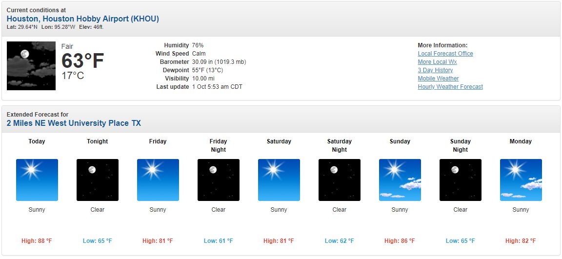
Good morning. Houston’s forecast remains on track, with a succession of mostly sunny days and weak fronts to keep a lid on temperatures and our air reasonably dry. Because there really is nothing else to talk about this morning, we’ll spare a few words on two tropical systems in the Caribbean. The tropics forecast is complicated, but likely inconsequential for the Houston area.

Friday

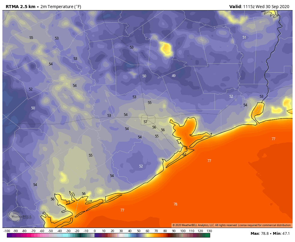
Drier air is moving into the region in the wake of a front on Thursday, and it feels splendid outside with lows generally in the 60s across the region, and dewpoints in the 50s. High temperatures today will reach into the low-80s under mostly sunny skies, with a light northeasterly breeze. It looks like low temperatures tonight will be the region’s coolest for the next several days, with lows on Saturday morning dropping into the mid-to-upper 50s for inland areas.

Low temperature forecast for Saturday morning. (Pivotal Weather)

Saturday and Sunday

Houston should have a pleasant fall weekend, with highs in the low 80s on Saturday. As winds shift to come from the southeast later in the day, we’ll see a slightly warmer night and then highs somewhere in the mid- or possibly upper-80s on Sunday. The passage of another weak front on Sunday may bring a few clouds, but generally we anticipate a sunny weekend.

Monday and Tuesday

The start of the coming work week should bring more of the same, with highs in the 80s, lows in the 60s, lots of sunshine, and a fair amount of dry air in the wake of Sunday’s front.

After that?

We may see another weak front by around Thursday, and this may bring some clouds into the sky and our first real chance of rain in awhile. But honestly, I don’t have much confidence in the forecast after the middle of next week, so we’ll have to get back to you on Monday.
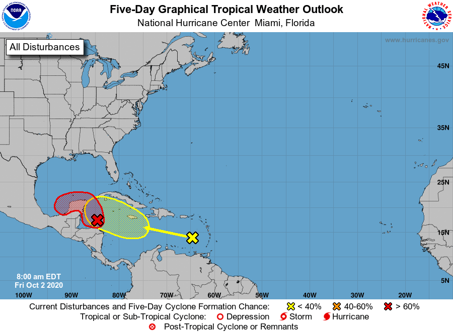
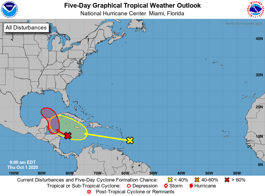
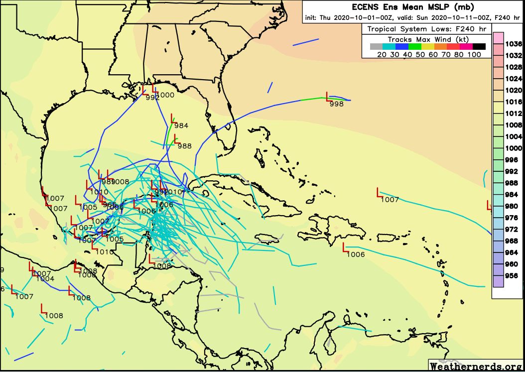
The Caribbean Sea is fueling two tropical systems. (National Hurricane Center)

The tropics

So there are still two systems in or near the Caribbean Sea that the National Hurricane Center is tracking. The low-pressure area near the Yucatan Peninsula now has an 90 percent chance of becoming a tropical depression or Tropical Storm Gamma over the next two days. It is being aided by the front that pushed through Houston several days ago, and deep into the Gulf of Mexico. This front is providing a northerly flow to help the storm complete a circulation, which has trade winds on the other side.

How an old front is helping to develop a circulation. (NOAA)

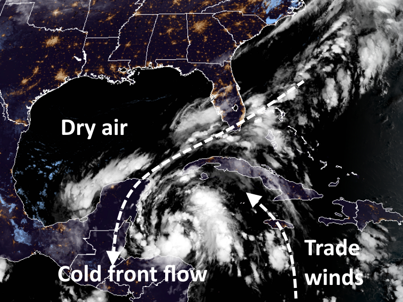
This system is likely to move toward the Yucatan Peninsula over the next day or two. There it may get swallowed up by interaction with land, dry air over the Gulf, and an not-great shear environment. However, it is possible that something emerges into the Bay of Campeche in a few days, and wanders around there—bottled up by the additional fronts coming into Texas and high pressure.

After this, who knows? It could get pushed into Mexico, eventually, or maybe pulled north or northeast. It remains very difficult to see this system (or the one behind it) affecting the upper Texas coast, but we’ll continue to watch it for you and update if anything changes. Have a great weekend!

Houston’s weather—sunny for as far as the eye can see

September ended last night, and all told Houston’s Hobby Airport recorded a total of 13.07 inches of rain during the month. This makes it the third wettest September at this location since records were first kept in 1930, the National Weather Service says. Moreover, out of the 1,069 total months of observations, this September ranks as the 20th wettest on record. It was in fact the wettest month at Hobby since August of 2017, when Hurricane Harvey impacted the region. There is no rain to speak of in our present-day forecast, however.

Thursday

Lows this morning are a few degrees warmer than Wednesday morning, and highs probably will shoot up into the upper 80s this afternoon with the fairly dry air and sunny skies. A front will push into Houston later this evening, but the dry and cooler air associated with it will lag, likely arriving Friday morning. Therefore lows Thursday night may only drop into the mid-60s in the city.

Would you like a side of sunshine with your sunshine, Houston? (National Weather Service)

Friday and Saturday

These will be a pair of fine, sunny days, with highs of around 80 degrees. Lows in Houston should drop to near 60 on both Friday and Saturday nights—with warmer conditions along the coast, and cooler weather prevailing inland. By Saturday the onshore flow should resume.

Sunday

This should be a slightly warmer day, with highs reaching the mid, or possibly upper 80s, beneath sunny skies. We still think a secondary push of dry air will back into the area from the northeast sometime on Sunday, although I’m not highly confident in how strong, or persistent it will be.

Next week

The the wake of Sunday’s (weak?) front, expect highs to likely stay within the low- to mid-80s for the first couple of days next week with lows in the 80s. As we’ve been saying this won’t be cold weather, but it will be mild. We still expect some clouds to begin dotting the skies by around next Wednesday as humidity begins to return with vengeance. Some slight rain chances return by Friday or so.

Tropics

The National Hurricane Center is now tracking two disturbances in or near the Caribbean Sea, and its five-day tropical outlook can look pretty intimidating at first glance. The first system, shown in red, has a 70 percent chance of developing over the next five days, and the follow-on system a 20 percent chance.

Tropical outlook for 7am CT on Thursday. (National Hurricane Center)

However, the reality is that the overall pattern suggests high pressure moving into Texas early next week should buffer the state from both storms. The map below shows the European model’s ensemble track forecast for all tropical lows from now through next Saturday. The model basically forces anything that forms into the Bay of Campeche, and of those that survive, a few eventually get pulled northeast toward Louisiana or Florida.

European model ensemble forecast for all tropical tracks through Saturday, October 10. (Weathernerds.org)

So here’s what we think. Is it annoying that there are two potential tropical storms looming in the Caribbean Sea? Sure. Do we believe any of them are likely to threaten Texas in a meaningful way? At this time it’s very difficult to see how that happens.


Houston enjoying its coolest morning since April

Temperatures this morning have fallen into the 50s across much of the city—with only the coast holding out at slightly above 60 degrees—and this is the coolest weather Houston has seen since mid-April. This is also as cold as it’s going to get for a while here. But the good news, if you like fall, is that we should see a few more fronts in the next week to keep our region on the mostly dry and mild side going into next week.

It’s an unreal fall morning across the Houston metro area. (Weather Bell)

Wednesday

Not much to say about today’s weather. We’re going to see sunny skies, with a high temperature in the mid-80s. Light winds will shift to come out of the southwest this morning, and that will slowly begin the process of returning the onshore flow. Lows tonight will probably be about five degrees warmer than Tuesday night.

Thursday

This will be a warmer day with the influence of a southerly flow, likely allowing high temperatures to push into the upper 80s under sunny skies. But just as Houston shows signs of heating up, a moderate push of cooler and drier air will arrive late Thursday night or Friday morning.

Friday and Saturday

This weak front should make for a splendid weekend, with highs in the low 80s, lows in the low 60s for all but the coast, and lots of sunshine. It’s not going to be “cold” by any stretch of the imagination, but it’s not going to be hot or humid either. This is fall in Houston!

Sunday

This should be another day like Thursday, as the influence of the onshore flow begins to warm things up. We should see highs in the mid- to upper-80s with partly sunny skies and moderately more humid air. However we think yet another weak (or maybe stronger?) front will arrive late on Sunday, or early Monday, to keep the heat and humidity in check.

Houston’s 7-day rainfall forecast is bereft of rainfall. (Pivotal Weather)

Next week

As a result of Sunday or Monday’s front, the early part of the week should keep us in the realm of highs in the 80s, and lows in the upper 50s to 60 degrees. Some clouds may return by the middle or end of next week, but our first real rain chances probably don’t come until next Friday or Saturday.

Happy Fall Day Houston—you’ve earned it

Houston’s temperature officially reached 65 degrees at Bush Intercontinental Airport this morning shortly after 2 am, and from there it kept on falling. By shortly before sunrise, the low had dropped to 57 degrees. At Hobby Airport, in the midst of the city, the low reached 59 degrees on Tuesday morning. It all feels rather spectacular, and worth celebrating Fall Day.

24-hour change in temperature on Tuesday morning. (Weather Bell)

Tuesday

Simply put, today will be fabulous. There still will be a bit of wind out of the north, but it won’t be like Monday’s gusty conditions. Highs will likely only reach about 80 degrees despite sunny skies. And this evening, well, temperatures should drop a degree or two below what we saw on Monday night beneath clear skies. Winds will be calm.

Wednesday

After another cool morning—chilly, even, for far inland areas—this should be another splendid day for the area, with highs in the low- to mid-80s. As the frontal air mass begins to modify, expect lows on Wednesday night to be several degrees warmer.

Low temperatures for Wednesday morning. (Pivotal Weather)

Thursday and Friday

These will be a pair of warmer days, with a few clouds possible on Thursday. Both days should see highs somewhere in the mid-80s, or possibly upper 80s on Thursday. Another, weaker front should push into Houston on Friday and this will set the stage for a nice weekend.

Saturday and Sunday

With another push of drier air, the first half of the weekend looks great, with highs on Saturday in the low 80s, and fairly low humidity. The onshore flow should return on Sunday, but I’d still expect highs to stay in the 80s, with plenty of sunshine. Should be a great weekend for outdoor activities.

European ensemble model for cloud cover (dark blue means none) for the next two weeks. (Weather Bell)

Next week

Right now it appears as though another modest front may make it into Houston on next Monday, or so, but details are a bit sketchy. The bottom line is that we expect mostly sunny skies through the middle of next week, by which time a chance of rain finally returns to the forecast.

Tropics

The National Hurricane Center has increased the chance that an area of low pressure in the northwestern Caribbean Sea will develop into a tropical depression or storm to 50 percent over the next five days. There are probably a couple of scenarios for this system, including a weaker storm tracking westward into Mexico, or eventually a strong storm moving north toward Florida. Again, while we can’t rule anything out, we have a hard time seeing how it would eventually move toward Texas.