One more potentially very wet day before rains subside a bit

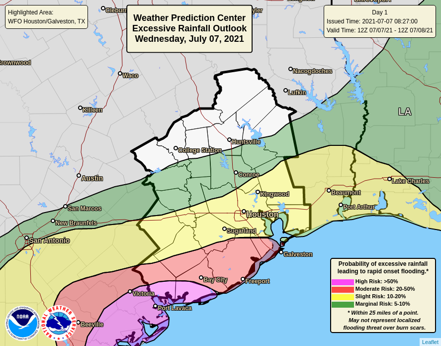
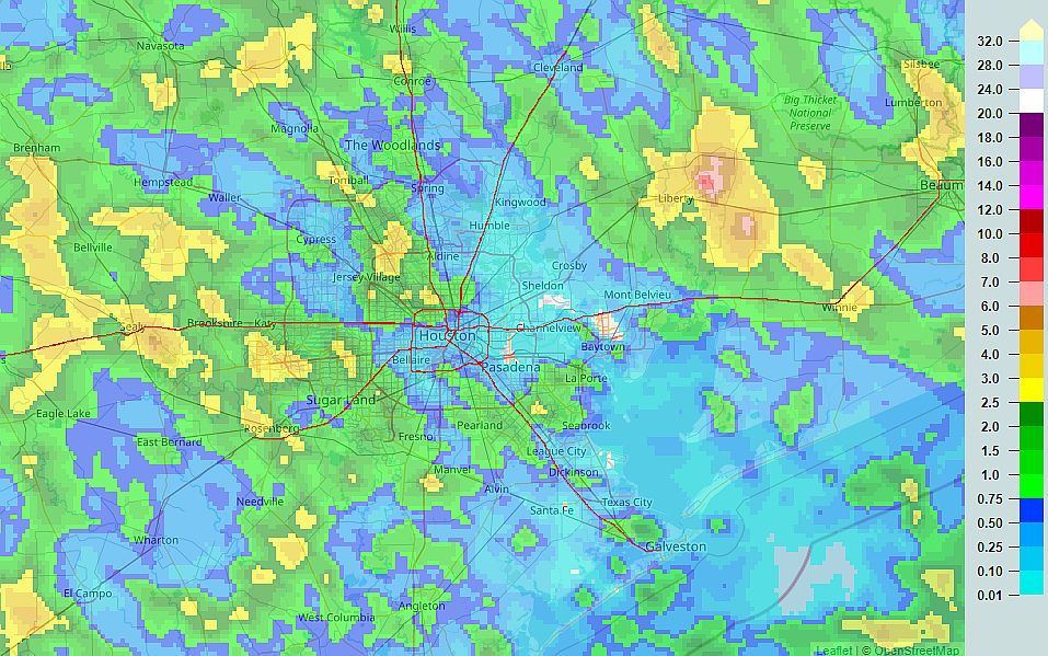
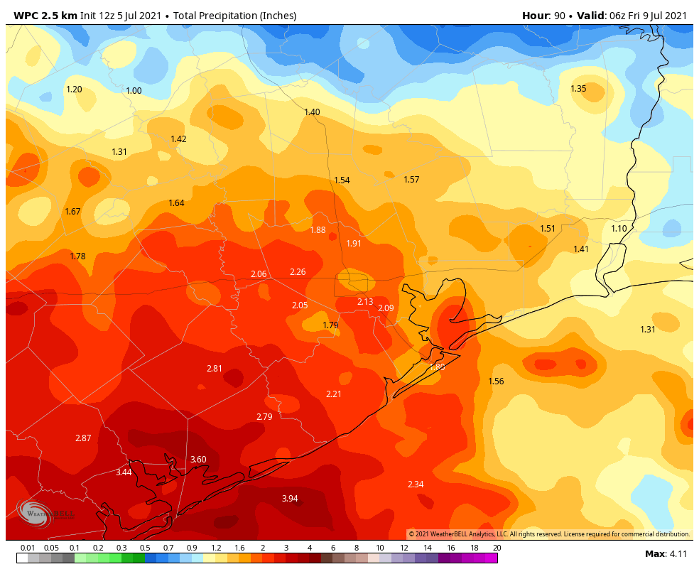
Good morning. While Houston has largely been spared by heavy rains over the last several days, a significant flooding event has unfolded to our south, with more than 10 to 15 inches falling in locations such as Rockport and Palacios along the Coastal Bend of Texas. These areas lie at significant risk again today. While Houston should see a wet day as well, accumulations will be lower in the metro area, especially along and north of Interstate 10. The threat for heavy rainfall should begin to back off somewhat on Friday.

Thursday

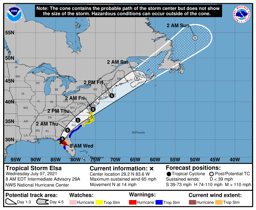
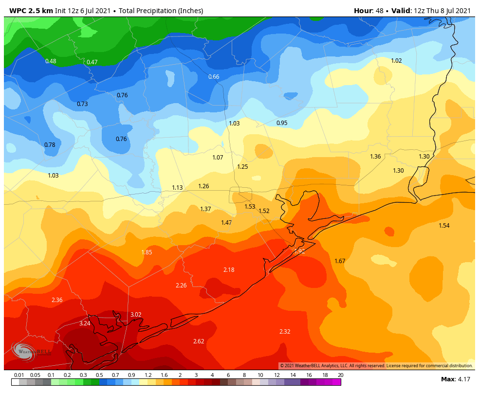
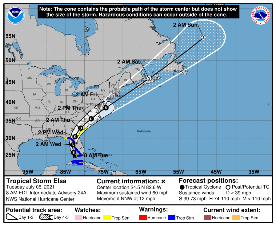
Texas’ coastal storms are being driven by a large area of low pressure over the southern part of the state that is drawing Gulf of Mexico moisture into the coast. This low should eventually weaken and move west later on Friday, but until that time very heavy rainfall will be likely for coastal areas, with the Coastal Bend the most favored area. An additional 3 to 6 inches are possible today from Corpus Christi through Matagorda Bay, with higher isolated amounts.

Closer to Houston, within the metro area, locations south of Interstate 10 may see 1 to 3 inches with higher isolated amounts, and areas north of I-10 likely will see 1 inch or less. These rains will again moderate highs, such that locations closer to the coast peak at about 80 degrees, with slightly warmer conditions inland. On and off stormy conditions may well continue overnight into Friday morning.

Excessive rainfall outlook for Thursday. (NOAA)

Friday

As the low eases westward, heavy rain impacts should be more scattered on Friday in the Houston region, but will not go away entirely. I still expect more than half of the area south of I-10 to see rainfall. Highs will again be in the low 80s, with winds increasing to about 15 mph from the east. Skies should remain partly to mostly cloudy.

Saturday

The first half of the weekend should see a mix of sunshine and clouds, allowing high temperatures to recover to about 90 degrees for much of the area. Afternoon showers will definitely be a possibility, but they should lack the organization of our recent, heavy rains.

By Saturday, the low pressure system should move into Mexico, and the heavy rain with it. (NOAA)

Sunday

This should be a sunny, warm day with highs in the low 90s. While I can’t entirely rule out some passing showers, most of the region should stay dry.

Next week

The forecast for next week remains somewhat uncertain, as it does not look like Houston will fall under the sway of a dominant ridge of high pressure. At the same time, right now there don’t appear to be any solid triggers for widespread rainfall. So perhaps we’ll strike a happy medium for July, with highs of around 90 degrees, partly sunny skies, and a chance of daytime showers? I would not turn that down at a time when temperatures can often push into the upper 90s, but for now we’ll have to wait and see.

Rains continue, with a serious flood risk near Matagorda Bay

Houston’s dreary pattern will continue for a few more days, especially over coastal areas, in the absence of high pressure to shut off rainfall. Our biggest concern lies well to the southwest of Houston, where several inches of rain have already fallen near Matagorda Bay. These areas are likely to see the potential for the heaviest rainfall again today and Thursday, raising our flooding concerns.

Wednesday

The overall pattern remains, with a broad upper-level low pressure system over coastal Texas that is helping to rain moisture down upon the Gulf, and parts of the state near the Gulf of Mexico. Showers are largely confined to coastal areas this morning, but models indicate they will push further inland later today, with areas north of Interstate 10 seeing at least a scattered chance of rainfall this afternoon.

For the Houston region, accumulations will likely be 1 to 3 inches right along the coast, with higher isolated amounts, and less than 1 inch for most inland areas north of Interstate 10. The map below, from NOAA’s Weather Prediction Center, shows the area along the upper Texas coast most at risk for heavy rainfall later today. Matagorda Bay could see 2 to 4 inches of rain, with higher isolated totals. Due to clouds and rain, highs today will likely be in the low- to mid-80s for much of our area.

Excessive rainfall risk for Wednesday. (NOAA)

Thursday

This will be another wet day, quite possibly a repeat of Wednesday in terms of rains and temperatures, with heavy rainfall along the coast, and especially southwest of Houston near Matagorda Bay. After all of this accumulating rain, areas such as Port Lavaca and Victoria could definitely see the potential for flooding, which is something to consider if your travels take you southwest of Houston, along the Highway 59 corridor.

Friday and Saturday

As the low-pressure system begins to depart the potential for heavy rainfall should start to diminish some, but both of these days should see the potential for widespread, intermittent showers. Skies will otherwise be mostly cloudy, with highs in the upper 80s to 90 degrees for most. Have a backup plan for any outdoor activities on Saturday.

Sunday and beyond

Sunday should bring the return of at least some sunshine to the region, although we’re probably not talking full-on blue skies. Beginning Sunday, and into early next week, we should see a more summer-like pattern, with highs in the low 90s, and a 20 or 30 percent chance of a passing shower during the afternoon due to heating and the sea breeze.

Elsa will soon skate away on the westerlies, accelerating to the northeast. (National Hurricane Center)

Tropics

Tropical Storm Elsa is approaching the coastal bend of Florida this morning with 65 mph sustained winds. After landfall today it will cross the southeastern United States, likely maintaining tropical storm-strength winds before reemerging into the Atlantic just off the eastern shore of the United States. It could bring messy conditions up the eastern seaboard on Thursday and Friday as it accelerates to the northeast. After Elsa, the Atlantic tropics should remain mercifully quiet for at least the next week or so.

Rainy pattern continues for Houston, helping to moderate highs

Good morning. Houston’s wet pattern continues with the potential for moderate to briefly heavy rainfall across the region this week. However, while it will be wet, these storms are mostly not producing flooded roadways. The upside is that cloud cover will generally keep our highs in the upper 80s this week at a time when the mercury often rises into the mid-90s.

Tuesday

The heaviest rains this morning are concentrated in the Matagorda Bay region, to the southwest of Houston. Short-term models suggest showers will most likely remain along and south of Interstate 10 today, with inland areas likely to have a drier day with perhaps no rain. As a result, inland highs may reach the upper 80s, with mostly cloudy skies, whereas the coast remains in the lower 80s. Winds will be light, out of the southeast, and rain chances will back off a bit this evening.

NOAA rain accumulation forecast for now through Wednesday night. (Weather Bell)

Wednesday

Wednesday looks similar to Tuesday, with storms starting near the coast or offshore, and again migrating inland. I would again expect better rain chances south of Interstate 10, with warmer temperatures near 90 degrees inland, and 80s closer to the coast. For Tuesday and Wednesday, overall accumulations north of Interstate 10 will probably be 1 inch or less, with 2 to 4 inches along the coast.

Thursday and Friday

The potential for organized storms starts to decrease Thursday as the atmosphere becomes slightly more stable. But we’re still going to see showers fire up with daytime heating, and I’d say about half of the area will at least see some brief showers on each of these days. High temperatures for most will likely get into the upper 80s.

Saturday and Sunday

At this point rain I think rain chances will probably diminish further for this weekend, likely into the 30 to 40 percent chance each day. Sunday probably has a better chance of seeing sunnier skies with only very scattered showers. However, the global models are not in great agreement about the pattern, so stay tuned.

Tropics

Tropical Storm Elsa is passing near the Florida Keys this morning, and will now move northward, just offshore the west coast of the Florida peninsula. Its primary threat remains rainfall, but it will also bring breezy conditions and swells to areas such as Tampa Bay today and tonight. After Elsa moves across Florida and up the Atlantic coast, the tropics should remain quiet for a few days—which is frankly how we expect things to be during early July.

Rains continue for Houston, but not expecting anything too serious

Good morning. After a wet weekend for some—a really wet weekend for the Liberty area, with more than 8 inches of rain—the greater Houston region will see an ongoing wet pattern for much of this week. However, these rains should be manageable for the most part, so we don’t anticipate significant flooding issues.

Rain accumulations during the July 4th weekend. (NOAA)

Monday

Today should be similar to the July Fourth holiday, with showers developing this morning and spreading inland. Accumulations will vary widely, with some areas seeing little rain, and others picking up a couple of inches. Areas most likely to see heavy rains are to the southwest of Houston, particularly the Matagorda Bay region. Skies should otherwise be partly sunny, with highs near 90 degrees, and light southeast winds. Rain chances will slacken overnight, but not go away entirely.

Tuesday and Wednesday

With high moisture levels in place, and an absence of high pressure, this fairly wet pattern should continue with additional chances of showers, thunderstorms, and briefly heavy rain. All of this will combine to limit high temperatures to the upper 80s to 90 degrees. In terms of accumulations, most of Houston should see 1 to 3 inches of rain through the middle of the week, with higher totals possible closer to the coast.

NOAA rain accumulation forecast for now through Thursday. (Weather Bell)

Thursday and Friday

Rain chances will begin to decrease on Thursday, and will probably drop back to about 20 or 30 percent by Friday. This should allow for a little more sunshine, and if sunny skies align with afternoon hours, some areas may see highs in the low 90s. Otherwise, much of the area may remain capped at about 90 degrees.

Saturday and Sunday

So is another soggy weekend in store? Although the forecast is not yet locked in, I don’t think we’re going to see full on rainfall this weekend, but each afternoon should see a decent chance of showers with at least partly cloudy skies. Highs will be around 90 degrees, with super high humidity.

Tropics

Tropical Storm Elsa will move across Cuba today, and then track up the western coast of Florida before making landfall, likely some time on Wednesday. It is not expected to do so as a hurricane, due to wind shear and its interaction with Cuba. The main threat, as usual from tropical storms, is rainfall. But so far the forecast does not look too extreme as these things go.

NOAA rain accumulation forecast for now through Friday morning. (Weather Bell)