Rain showers likely today, with hotter and sunnier weather ahead

This August has been fairly wet by Houston standards, especially in absence of a tropical system to drive widespread showers, but we may soon revert to normal. It looks like we’ll get one more burst of high rain chances today before high pressure begins to assert itself. This will lead to a period of hotter and mostly sunny weather for probably a week or so, with highs eventually pushing into the upper 90s. Would we expect anything different in late August?

Wednesday

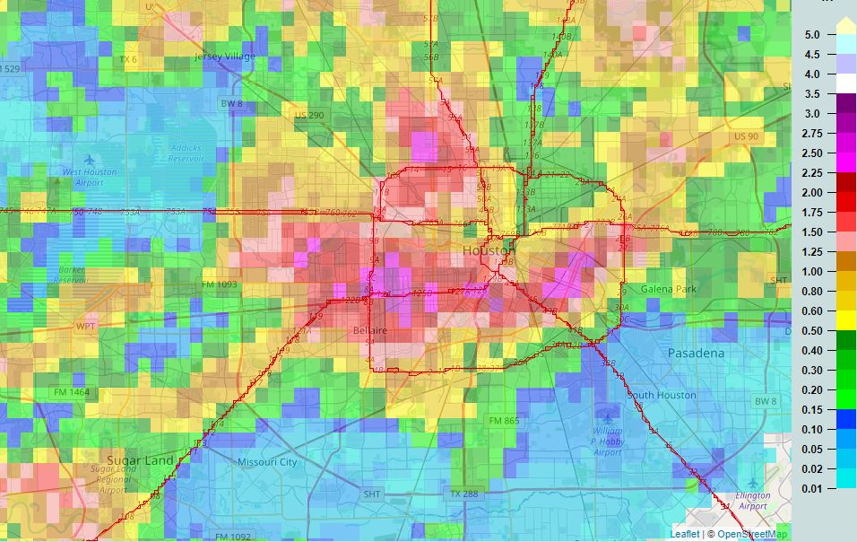
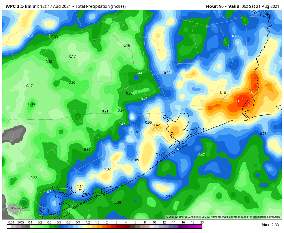
Today’s rainfall will be driven by high atmospheric moisture levels in concert with an area of low pressure. This activity should spread inland this morning and last until sunset and the loss of daytime heating. About 75 percent of our area should see rain. Most will see accumuations on the order of 0.5 inch but we cannot rule out a few bullseyes of 2 to 4 inches that may cause temporary street flooding. The better chances for heavy rainfall should be along and southeast of Interstate 69/Highway 59. The rains and partly cloudy skies should limit highs to the low 90s today, with light southeast winds.

NOAA rain accumulation forecast for Wednesday. (Weather Bell)

Thursday and Friday

These days will be warmer, with mostly sunny skies, and highs in the mid-90s. Rain chances will fall back to around 30 percent for both days, which means showers will be more isolated to scattered, and most likely to occur during the afternoon. Winds will remain out of the south and southeast, and may become a little more gusty on Friday.

Saturday and Sunday

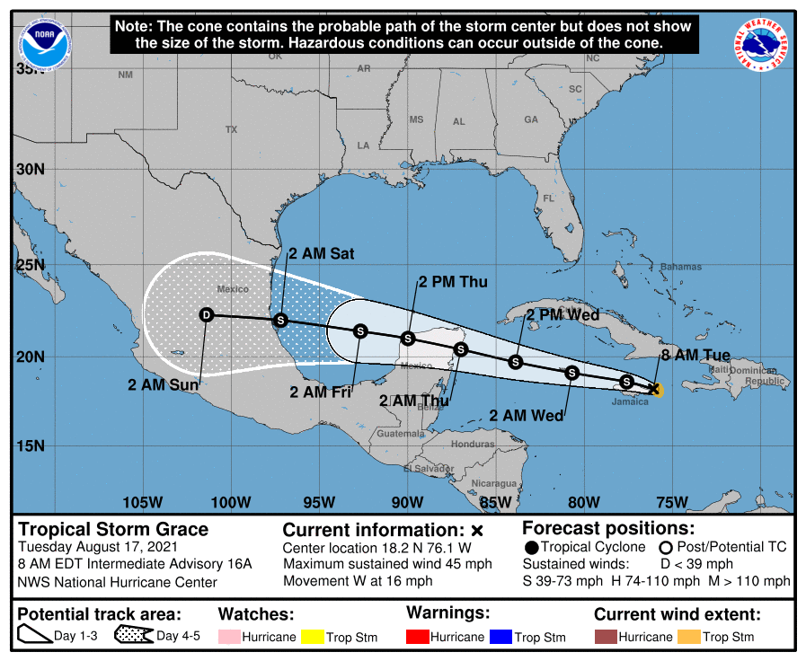
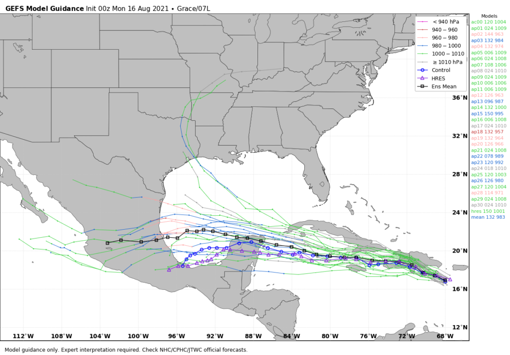
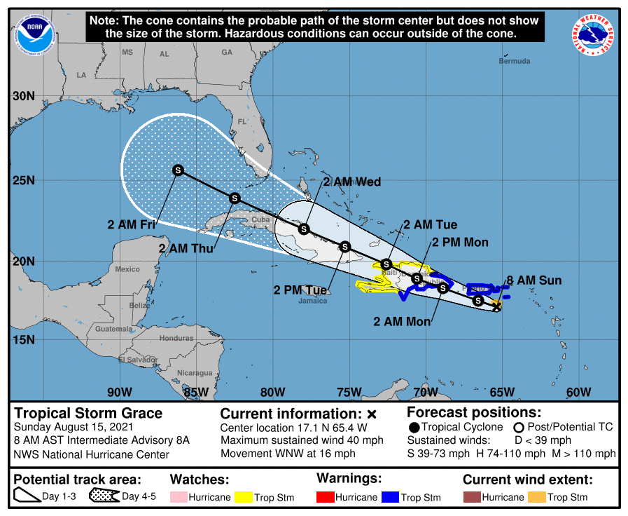
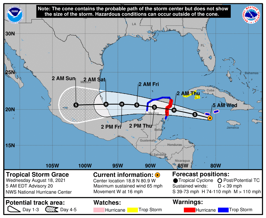
The weekend looks hot and sunny, with highs in the mid- to upper-90s and mostly sunny skies. We can’t rule out some isolated rain showers, but chances each day are probably 20 percent or less. If you’re headed to the beach, rip currents may be stronger than normal due Grace, which likely will be a hurricane at that time, moving through the Bay of Campeche.

Next week

Frankly most of next week looks hot and sunny, with highs in the upper 90s. I really don’t see much in the way of rain chances returning until the end of next week or so. August will be doing August things.

Grace will remain well south of the United States. (National Hurricane Center)

Tropics

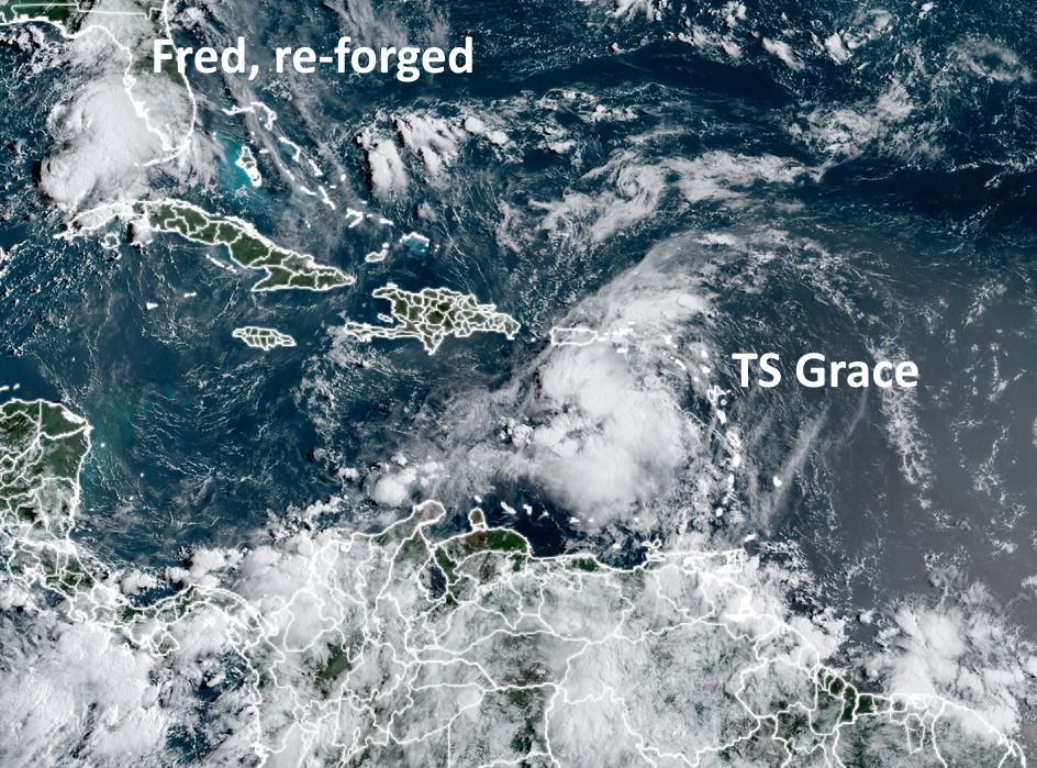
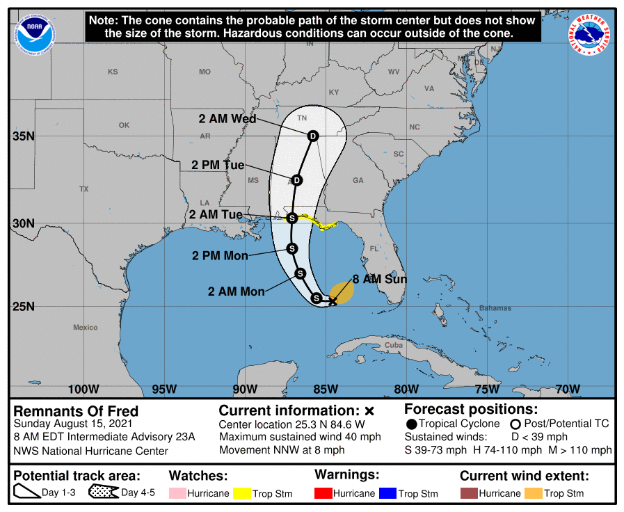
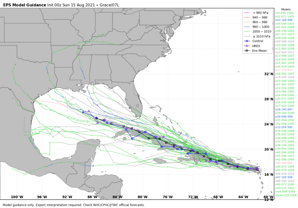
Fred is dissipating over the Appalachian mountains this morning, and bringing heavy rains to West Virginia and Ohio. Grace is nearing hurricane strength, and will likely strike the Yucatan Peninsula on Wednesday night as hurricane. It will then hit the main part of Mexico this weekend, likely near Tampico, as a strong hurricane. In the Atlantic, Tropical Storm Henri is likely to stay offshore, but may come relatively close to the northeastern United States as a hurricane this weekend.

Things look quiet for a spell after these storms pass.

Healthy rain chances continue before a hot August weekend

Some areas along the Southwest Freeway and Loop 610 saw very heavy rainfall on Monday, with storms briefly producing about 1.5 inches in 15 minutes. While overall totals for much of this area were only 2 to 4 inches, the intensity of this rainfall nonetheless produced significant street flooding. This is a testament to the power of rainfall rates, which are just as important as rainfall totals. A rate of 2 inches per hour, or more, will quickly back up streets. A healthy chance of rain will remain until the weekend, when high pressure should yield more sunny skies across the region.

Monday’s rainfall totals. (NOAA)

Tuesday

Skies should be partly to mostly sunny, with highs pushing into the mid-90s. High resolution models indicate that storms should again form in the metro area this afternoon and evening, before waning around sunset. I suspect about 40 percent of our region will see showers, with storms likely not as intense as on Monday. Winds will be light, out of the southeast at 5 to 10 mph.

Wednesday

Slightly higher moisture levels and more of an impetus for rising air should lead to better rain chances on Wednesday, with perhaps 60 percent or more of the area seeing showers or thunderstorms during the afternoon and evening hours. Highs will probably slot into the low 90s, with partly sunny skies.

Thursday and Friday

These should be mostly sunny days with highs in the mid-90s. Afternoon shower chances will remain, with perhaps one-third to one-half of the area receiving some rainfall each day.

NOAA rainfall forecast for now through Friday. (Weather Bell)

Saturday, Sunday, and beyond

As high pressure establishes itself more firmly, rain chances will fall back to about 20 percent for this weekend. As rain chances fall, temperatures will go up, and I expect a hot weekend with highs pushing into the upper 90s for inland locations. This hot and sunny trend likely continues into next week with August-like weather for our region. The good news? August is now more than half over, my friends.

Tropics

There are three named storms active in the tropics this morning. Tropical Depression Fred has moved inland into the Southeast United States. Tropical Storm Henri is swirling around Bermuda, and will stay away from the United States. And then there’s Tropical Storm Grace, which is nearing Jamaica. Confidence is now high that this system will continue traveling due west, across the Yucatan Peninsula, into the Southern Gulf of Mexico, and ultimately into Mexico. It is not a threat to Texas.

Tropical Storm Grace track forecast. (National Hurricane Center)

After these three storms we may see a bit of a lull in activity—but no promises as we’re in the middle of August.

Light winds not helping with La Porte chemical release

Good morning, Houston. Our region will continue to see healthy rain chances this week through around Wednesday, after which high pressure should bring them back into the 20 to 30 percent range. Highs will be generally in the low- to mid-90s. It now appears likely that our region will not be affected by Tropical Depression Grace.

Monday

Very light winds overnight, essentially 0 mph for some locations, have been problematic due to a chemical release in the La Porte area at the Lubrizol Plant on Sunday evening. Unfortunately there is very little reliable information online about this incident, but in areas from La Porte to Seabrook to Friendswood and beyond there has been a distinct “oily” odor in the air that has made people feel unwell. I wish I had more information about the chemical in question, but I don’t. I do know that the lack response by local and officials so far has been unacceptable. Winds will remain light this morning, but should be 5 to 10 mph this afternoon.

Winds are very light this morning across the Houston region. (Weather Bell)

Chemical odor aside, today should be similar to Sunday, with highs in the mid-90s and healthy rain chances. For some that will mean a quick 1 to 2 inches of rainfall under a strong thunderstorm, and for others that will mean hearing the rumble of nearby thunder, with little or no rainfall. Rain chances will peak this afternoon and then wane this evening. Skies should be mostly cloudy.

Tuesday and Wednesday

This unstable pattern continues through Tuesday and Wednesday, with partly to mostly cloudy skies, highs in the low to mid-90s, and healthy rain chances peaking alongside daytime heating.

Thursday and Friday

A building ridge of high pressure should return Houston to more summertime weather toward the end of this week, and by that I mean afternoon showers should become more isolated to scattered, with skies becoming at least partly sunny. Highs will be in the mid-90s.

Saturday and Sunday

Assuming the tropics forecast holds—more on that below—this weekend should be most sunny, with a continued chance of scattered afternoon showers to go along with mostly sunny skies. In short, it should be a fairly typical August weekend for the region.

Tropics

As one would expect during August, the tropics are active. Tropical Storm Fred should reach the Florida Panhandle this evening as a strong tropical storm, bringing rains and stronger winds to places such as Destin and Panama City. Fortunately the storm is moving at a good clip to the north. And near Bermuda, Tropical Depression Eight has formed. But aside from affecting Bermuda, this system should remain offshore the mainland United States.

The vast majority of GFS ensemble members keep Grace well south of the United States. (Weather Bell)

This leaves us with Tropical Depression Grace, which continues to move more due west than anticipated. Along this track its center will pass south of Hispaniola and Cuba (flash flooding remains a distinct possibility for these islands, unfortunately). This track means there is less of a chance that the storm will be shredded by the higher elevated terrain of these islands.

Models have also come into better agreement about Grace’s track. Given the high pressure building over the northern Gulf of Mexico, the storm is now expected to move more or less to the west, across the Yucatan Peninsula, the Bay of Campeche, and into Mexico. While we certainly cannot rule out direct impacts to Texas, their likelihood seems fairly low at this time. Grace probably will remain a tropical storm, but intensification into a hurricane cannot be ruled out this week.

Tropics Update: Fred in the Gulf, Grace headed there

Good morning. A “cool” front has essentially stalled across the metro area, and this will lead to partly sunny conditions today and Monday, with about a 50 percent chance to rain to go along with temperatures in the low- to mid-90s. Some rains today could briefly pulse up into strong thunderstorms, so be weather aware if you are outdoors.

The main purpose of this post, however, is to discuss the tropics and impacts to the Gulf of Mexico. We have had lots of questions over the last day because a single model run of the GFS on Saturday appeared to bring “Hurricane Grace” toward Texas late this week. We cannot emphasize this enough: a single model run, especially an outlier, should always be looked up with a high amount of skepticism. Anyway, herein is what we know as of Sunday morning about Fred and Grace.

Satellite image showing tropical storms Fred and Grace on Sunday morning. (NOAA)

Tropical Storm Fred

Fred has re-formed in the southeastern Gulf of Mexico, and confidence is fairly high that it will get pulled north later today, and head toward Alabama and the Florida Panhandle. Fred could become a strong tropical storm before landfall, so there may be some wind impacts in the Panhandle to go along with several inches of rainfall. By Tuesday afternoon it should be moving well inland and weakening quickly.

Track forecast for Tropical Storm Fred. (National Hurricane Center)

Tropical Storm Grace

For our purposes, Grace is the storm of more interest, although the forecast is highly uncertain. As of 8am CT on Sunday morning, Grace is rather disorganized and barely a tropical storm. Its center is south of Puerto Rico and likely to move onshore Hispaniola (which is two countries, the Dominican Republic and Haiti) during the next 24 hours. After a devastating earthquake on Saturday the last thing Haiti needs is a tropical storm, but that is nonetheless what is coming on Monday.

Forecast track for Tropical Storm Grace. (National Hurricane Center)

The first real question is whether Grace survives its interactions with Hispaniola and Cuba from Monday through Wednesday. I think there is probably at least a 50 percent chance the tropical system gets shredded by the terrain of these two large Caribbean islands.

However, if some low-pressure center emerges into the Gulf of Mexico around Wednesday, what happens then? The environment in the Gulf of Mexico, in terms of dry air and shear, will be OK but not ideal for intensification. I would put the chance of Grace ultimately becoming a hurricane in the Gulf of Mexico at about 10 to 20 percent. That is a rough estimate based upon ensemble forecasts, and is only to help you calibrate your own expectations right now.

In terms of track, Grace is really hard to pin down because a) its center is ill defined, b) this center will likely to jump around as it interacts with land and/or re-forms in a new location, and c) where it would ultimately make landfall in the Gulf of Mexico is a forecast still 6 to 8 days from now. However, should a center survive interactions with the Caribbean Islands and emerge into the Gulf next week, I expect it would move more generally westerly, toward Texas or Mexico, with impacts perhaps next weekend.

European model ensemble forecast for Tropical Storm Grace. (Weather Bell)

However I can’t stress enough the uncertainty with all of this, and that there will probably be some wild swings in model forecasts in the coming days.

The bottom line is that we’re in the middle of August, and this is a time of year when we are always watching the tropics keenly. Any time there is the possibility of a low-pressure center entering the Gulf of Mexico during August we need to monitor it. And we will. But for now the overall chance that Grace becomes a serious and direct threat to Texas remains fairly low.

We’ll have a full update on Houston’s weather and the tropics on Monday morning.