Spring gets sprung this week for Houston

Good morning. Today is the last day of “climatological winter,” which runs from December through February. And perhaps fittingly, while we are starting out cold this morning, we will end up warm this week. In fact, most of the week looks pretty lovely, with lots of sunshine and high temperatures mostly in the 60s and 70s. Enjoy the splendid weather Houston!

Monday

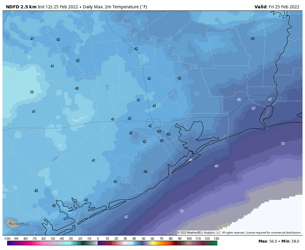
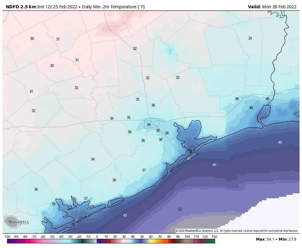
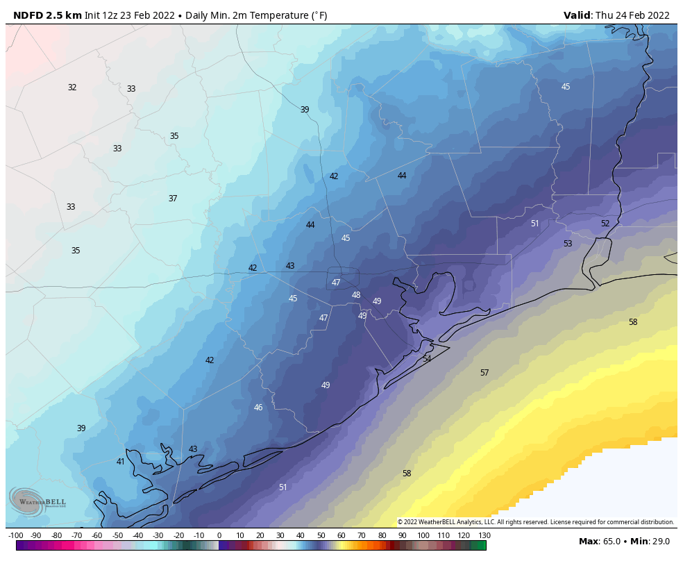
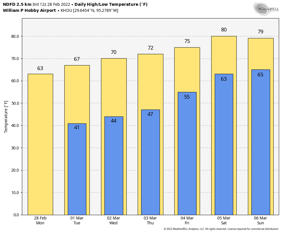
It is quite chilly this morning, with low temperatures mostly in the low to mid-30s across the region. But ample sunshine should help push high temperatures this afternoon into the low- to mid-60s, with light northerly winds. Overnight lows will probably drop to around 40 degrees in Houston, with upper 30s possible again for inland areas, and warmer conditions right along the coast.

If you’re headed out to the Houston Livestock Show and Rodeo tonight to see Cody Johnson, temperatures this evening will be in the mid-50s, with light winds and clear skies. After the show, the temperature probably will have dropped several degrees, into the upper 40s, but otherwise there will be no weather concerns.

Tuesday

This should be another partly to mostly sunny day, but with high temperatures reaching the upper 60s to 70 degrees for most areas. Winds will again be light. Overnight lows will be a few degrees warmer, likely in the mid-40s for most.

We’ll climb the stairs with temperatures this week. (Weather Bell)

Wednesday and Thursday

With high pressure still largely holding sway, we should continue to see partly to probably mostly sunny skies, with highs slotting somewhere in the low- to mid-70s, and overnight low temperatures in the 40s and 50s.

Friday, Saturday, and Sunday

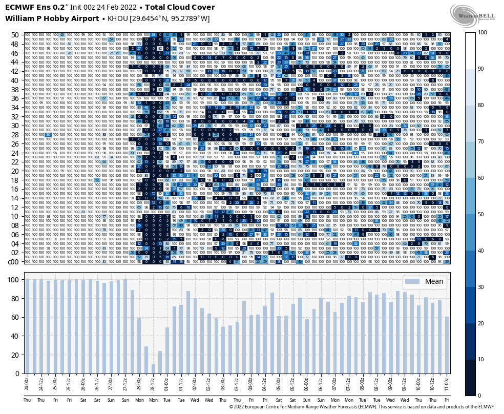
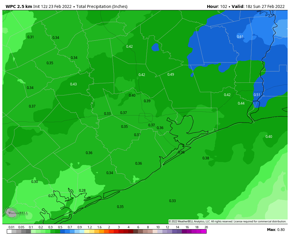
The onshore flow will resume later this week, and by Friday we’ll start to see the influence of this in the form of more clouds and humidity. This will set the stage for a partly to mostly cloudy Friday and weekend, with highs in the upper 70s to low 80s. Overnight lows will rise to the low 60s this weekend, with nearly matching dewpoints. At this time rain appears unlikely, but the chance is not zero. Our next front, which looks fairly weak, probably won’t come until at least next Monday. Spring, as they say, is about to be sprung.

Quite chilly for now, but next week we step toward spring

Good morning. Houston’s weather will be cold and gray, with occasional light rain, for the next two days before sunshine returns on Sunday. By Monday we’ll begin a slow warming trend that will see our temperatures rebound toward more spring like-weather for awhile.

Friday

The weather for today, however, is just going to be rather grim. We’ll see some light showers moving from south to north this morning, and when its not raining skies will be gray. As a result, high temperatures today will only warm a few degrees above this morning’s lows, probably into the mid-40s for most. On top of this, winds will blow out of the north, gusting as high as 20 mph. Simply put, this isn’t going to be a day for outdoor activities. While rain chances slacken this afternoon and overnight, clouds will remain, with low temperatures perhaps falling to around 40 degrees.

Your forecast for HIGH temperatures on Friday. (Weather Bell)

Saturday

The first half of the weekend will bring more of the same, with gray skies and a decent chance of light rain or misty precipitation moving in from the southwest throughout the day and overnight. Highs may reach about 50 degrees on Saturday, but skies will remain gray, with northeasterly winds. Lows Saturday night should drop into the low 40s.

Sunday

As high pressure starts to assert its influence over the region we’ll finally begin to see some breaks in the clouds, but this may not come until the afternoon hours. While the prospect of sunshine should allow highs to nudge up into the upper 50s, there will still be a northerly breeze at 10 to 15 mph that will keep things on the cool side. As skies clear, temperatures will drop on Sunday night, and possibly reach the mid- to upper-30s on Monday morning. A light freeze is not out of the question for some inland areas.

Current forecast for low temperatures on Monday morning. (Weather Bell)

Next week

Highs will start out in the 60s on Monday next week, and probably end up around 80 degrees by the weekend. Similarly, Monday and Tuesday mornings will be quite chilly before lows reach around 60 degrees next weekend. Days will see a mix of sunshine and clouds, but for now there looks to be little if any rainfall through at least Thursday or Friday. Bottom line: It will be a nice contrast to this week’s gray and cold, and a promise of warmer things to come this spring.

Cold and gray will be the way for the next few days

Good morning. Cold, gray weather has descended upon the Houston metro area, and this will be our new normal until at least Sunday. To the northwest of the metro area, in Washington, Brazos, and Grimes counties, there is a winter weather advisory due to light freezing rain. These areas should warm sufficiently above freeze by around 9 am this morning for the threat to lift. For the rest of us the region should simply see cold and cloudy conditions, with intermittent light rain or drizzle for the next few days.

Your high temperatures on Thursday will not be particularly warm. (Weather Bell)

Thursday

Today will not see significant warming due to thick clouds, so expect highs in the upper 30s for far inland areas to the northwest, the low 40s for places like Katy and The Woodlands, upper 40s for central Houston, and lower 50s for the coast. Some light showers are possible this morning, but overall rain chances are probably less than 30 percent for most of the region today. The potential for some light rain increases a little bit tonight, so there may again be the threat of some light, freezing rain in places like Washington, Brazos, and Grimes counties to the northwest of the metro area. Lows in Harris County, and counties immediately surrounding it, should remain above freezing.

Friday

Expect another cold and gray day. Highs will generally reach the upper 40s for most of the area, with the further potential for some light rain, although for most of us there probably will just be clouds. Friday night will be cold again, but temperatures should be a few degrees warmer than Thursday night, with lesser rain chances.

Saturday

We should see more of the same, with leaden skies and highs perhaps around 50 degrees in Houston, with cooler weather for inland areas. One more system will push through the area later on Saturday and Saturday night, bringing yet another decent chance of light rain overnight, as lows drop into the 40s.

Sunday

As high pressure starts to assert some control over our weather we should see partially clearing skies at some point on Sunday, with highs perhaps pushing into the upper 50s to 60 degrees. Rain chances should end during the morning hours. Lows on Sunday night should drop into the low 40s, give or take, with the clearing skies.

We can pretty much expect 100 percent cloud cover until Sunday afternoon, at the earliest. (Weather Bell)

Next week

We’ll see a progression of warmer days next week, with highs probably somewhere in the 60s on Monday rising to around 80 degrees by next weekend. Skies look to be partly sunny, with no major issues to look out for at this point. This could be the transition from winter into spring.

The first front makes it, and gray and chilly weather is our new normal until Sunday

Good morning. The first of two cold fronts has now pushed into the region, and this will set the stage for cold, gray, and occasionally wet winter weather for awhile. Do not expect to see much, if any, sunshine before Sunday. This is probably the region’s last prolonged bout with chilly weather, as spring is probably coming in March.

Wednesday

It is now clear that this week’s first front will make it all the way to the coast. As a result, temperatures today will be in the 50s for most of the area, with occasional light rain and cloudy skies. Winds will blow out of the north at around 10 mph, with higher gusts. Low temperatures tonight will vary quite a bit across the region, from the mid-30s for far inland areas to the low 50s right along the coast.

Low temperatures on Thursday morning will vary widely across the region. (Weather Bell)

Thursday

This will be a cool and gray day for the region, with high temperatures likely ranging from 45 to 60 degrees across Houston to go along with leaden skies. There is the possibility of some light rain on Thursday, but any showers that do develop should be scattered, and any amounts very light. Rain chances are better Thursday evening and overnight as another front pushes through, but any accumulations should again be slight, perhaps one-tenth of an inch, or so. Lows on Thursday night will drop into the 40s.

Friday

A few showers may linger after the second frontal passage, but mostly I think we’ll just see cloudy skies on Friday. Highs will probably top out at around 50 degrees for most areas, with a northerly breeze that could gust to 20 or 25 mph. Rain chances drop to near zero by Friday night.

Saturday

This will be another chilly and gray day, with highs likely in the 50s. We’ll see one more healthy chance of light rain as an atmospheric disturbance moves overhead. This will precede yet another front that should cross the area Saturday night, and finally usher in some high pressure. Lows Saturday night will be in the 40s.

Despite on and off rain chances through Saturday night, overall accumulations won’t amount to much. (Weather Bell)

Sunday and beyond

Under the influence of high pressure, skies should clear out some on Sunday, perhaps during the late morning or afternoon hours. Expect high temperatures to reach about 60 degrees. This will begin a slow warming trend, with most of next week seeing highs in the 60s and 70s, with lows in the 50s, and partly to mostly sunny skies. So if gray and cold is not your bag, baby, then next week should be more to your liking.