Good morning. The first of two cold fronts has now pushed into the region, and this will set the stage for cold, gray, and occasionally wet winter weather for awhile. Do not expect to see much, if any, sunshine before Sunday. This is probably the region’s last prolonged bout with chilly weather, as spring is probably coming in March.
Wednesday
It is now clear that this week’s first front will make it all the way to the coast. As a result, temperatures today will be in the 50s for most of the area, with occasional light rain and cloudy skies. Winds will blow out of the north at around 10 mph, with higher gusts. Low temperatures tonight will vary quite a bit across the region, from the mid-30s for far inland areas to the low 50s right along the coast.
Thursday
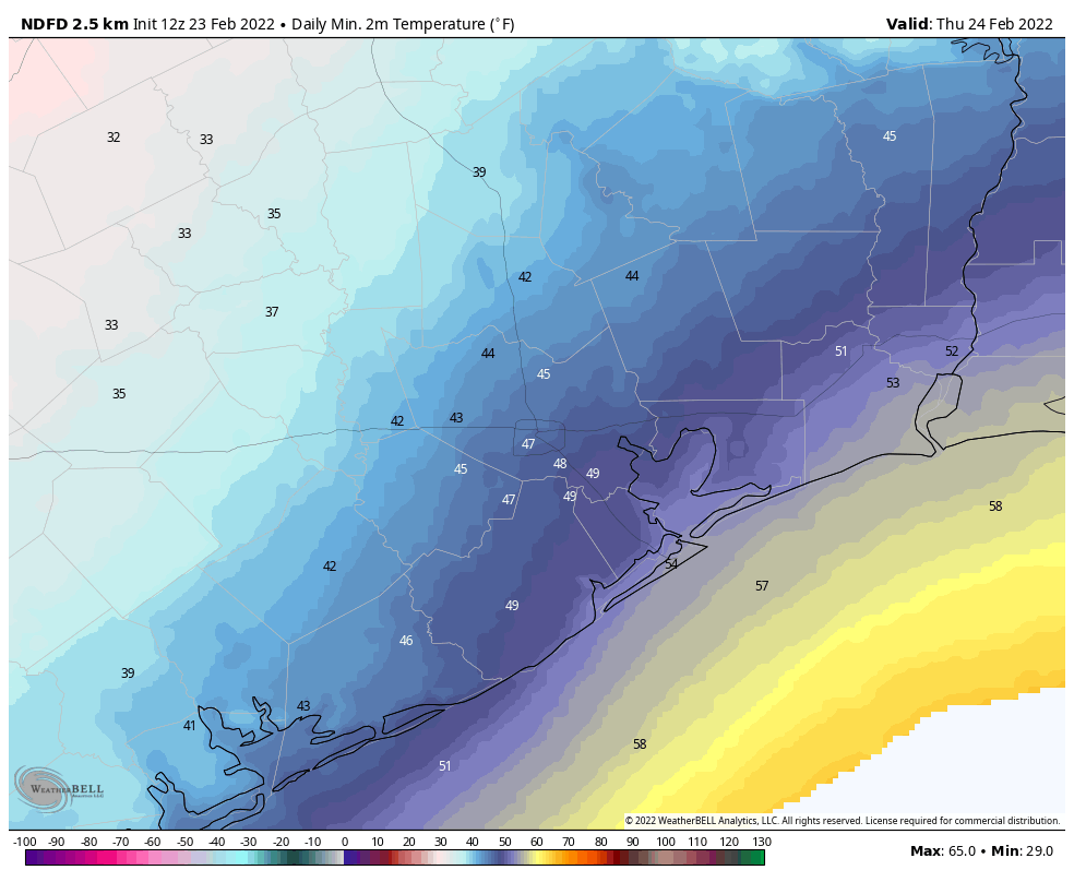
This will be a cool and gray day for the region, with high temperatures likely ranging from 45 to 60 degrees across Houston to go along with leaden skies. There is the possibility of some light rain on Thursday, but any showers that do develop should be scattered, and any amounts very light. Rain chances are better Thursday evening and overnight as another front pushes through, but any accumulations should again be slight, perhaps one-tenth of an inch, or so. Lows on Thursday night will drop into the 40s.
Friday
A few showers may linger after the second frontal passage, but mostly I think we’ll just see cloudy skies on Friday. Highs will probably top out at around 50 degrees for most areas, with a northerly breeze that could gust to 20 or 25 mph. Rain chances drop to near zero by Friday night.
Saturday
This will be another chilly and gray day, with highs likely in the 50s. We’ll see one more healthy chance of light rain as an atmospheric disturbance moves overhead. This will precede yet another front that should cross the area Saturday night, and finally usher in some high pressure. Lows Saturday night will be in the 40s.
Sunday and beyond
Under the influence of high pressure, skies should clear out some on Sunday, perhaps during the late morning or afternoon hours. Expect high temperatures to reach about 60 degrees. This will begin a slow warming trend, with most of next week seeing highs in the 60s and 70s, with lows in the 50s, and partly to mostly sunny skies. So if gray and cold is not your bag, baby, then next week should be more to your liking.
Our cheer team is driving to Dallas Thursday for a big competition (1400+ teams). Can you give some insight on when might be the best time for driving in Dallas tomorrow? Looks like late afternoon…possibly…
I went to sleep this morning around 8, woke up a little before 2 this afternoon and was surprised to see the temperature in the upper 30s out here in Sealy. Now I see the greater Houston area is under a winter weather advisory until Thursday morning, not what I saw in any of the forecasts the last couple days.
Apparently there is freezing rain very close to the Houston area. I don’t remember any mention of wintry precip in any recent posts. Are you going to have an update?