Pleasant weather plodding along, punctuated by periodic fronts

It is pretty clear that the worst of winter is now behind us in Texas, and while winter is by no means “over,” we should see generally pleasant conditions going forward. Occasional cold fronts will probably ensure that outcome at least through next weekend.

Today

Fog is around much of the area outside the city this morning, so take some care while driving.

We’ll see plenty of sunshine again today, but there should be at least a few clouds around. We’ll warm back into the 70s again this afternoon.

Saturday

I think tomorrow will come with mixed reviews. We have a cold front that will push through the region in the morning. This will probably bring at least a broken line of showers or some rain through the area in the morning hours. So if you have outdoor plans, I might suggest the afternoon over the morning if possible. However, that may also come with a price tag in the form of cooler temperatures. No 70s on Saturday; we’ll see temperatures likely peak in the 50s in the morning and then probably stay there Saturday afternoon.

With a noticeable breeze included, 15 to 25 mph at times, it will feel like February.

Sunday

Temperatures will drop through the 40s and into the 30s Saturday night, bottoming out in the 30s in most areas away from the coast. Look for AM lows perhaps at or below freezing up near Conroe or in some isolated spots outside the city and suburbs.
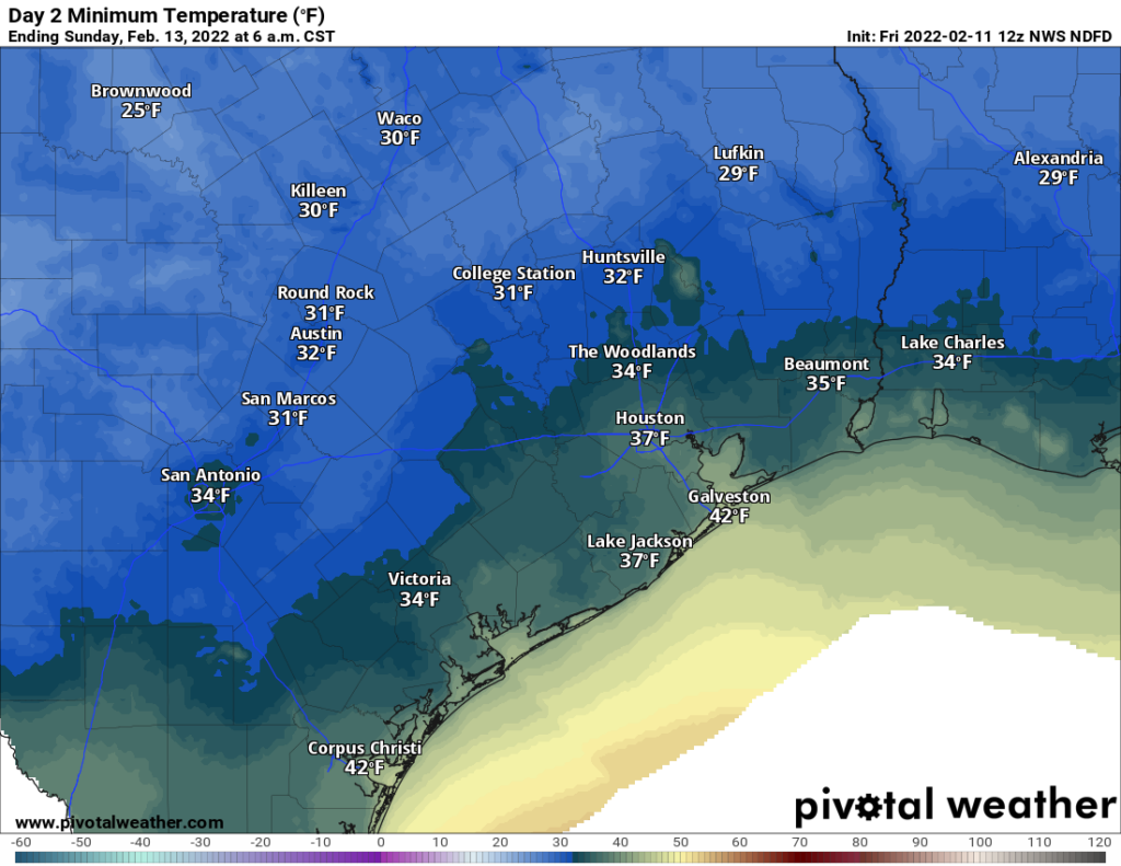
Sunday morning lows will be back in the 30s with a light freeze possible well outside the city to the north and west (NWS via Pivotal Weather)

Sunday itself will be delightful with sunshine, diminishing winds, and highs near 60 degrees.

Monday & Tuesday

Look for continued pleasant weather on Valentine’s Day with temperatures starting in the 30s and warming into the 60s. Dining al fresco will be cool but probably tolerable with evening temperatures around 60 degrees, give or take. Winds will be light. Tuesday should be similarly nice, with sunshine and upper 60s after morning 40s.

Beyond Tuesday

We’ll see a pretty aggressive warm up begin Tuesday night and Wednesday with a 10+ day stretch of sub-50 degree low temperatures likely ending on Wednesday. Temperatures will warm into the 70s on Wednesday and not drop below 60 degrees on Wednesday night. Our next cold front is aiming for Thursday, and Thursday’s temperatures will depend on the exact timing of the front. If it’s late in the day, we’ll go deep into the 70s, but if it’s earlier, we may not get much past the mid-60s. More on that for you Monday.
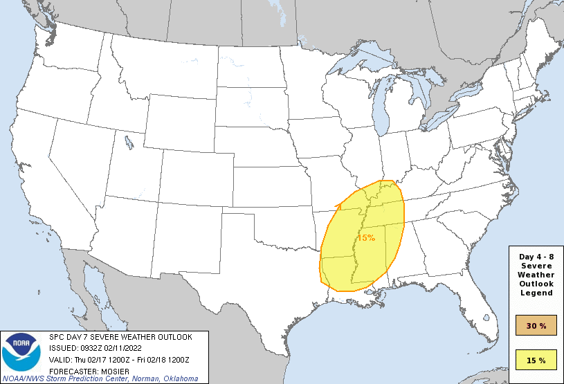
The Storm Prediction Center is already highlighting the potential for severe weather north of our area on both Wednesday and Thursday (shown here). While this setup looks difficult for the Houston area to get severe weather, it will be worth watching at least for Thursday. (NOAA)

As far as actual weather goes, we’ll likely contend with some fog at times on Wednesday and Thursday, in addition to clouds and sun. Thursday’s front may come with a bit of punch, so I suspect we’ll be tracking thunderstorms, particularly north of I-10 as it passes through. The Storm Prediction Center is already highlighting days 6 and 7 for severe risks in North Texas (Wednesday) and northern Louisiana (Thursday). This looks like a more classic Houston situation where “capping” in the atmosphere will be present for us, limiting risk of severe weather. But we’ll give you more details on that next week. Fair, cooler weather should build in for Presidents’ Day weekend.

As a reminder, you can download the Space City Weather app on your Apple or Android device. And if you o or someone you know would prefer your weather information in Spanish, please check out our Spanish language companion site, Tiempo Ciudad Espacial, helmed by Maria Sotolongo!
Splendid and sunny weather continues, but for a brief interruption on Saturday

Houston experienced spectacular weather on Wednesday, and this pattern will continue until a cold front shakes things up a bit this weekend. Still, the overall plan is for nearly continuous sunshine through the early part of next week.

Thursday

Lows are generally in the low 40s this morning, but with mostly sunny skies this afternoon highs will reach 70 degrees, or just a tad warmer, for most locations. Winds will be light, from the west, at perhaps 5 mph. A few clouds may form tonight, with lows likely dropping into the low-to-mid 40s—a few degrees warmer than Wednesday night.

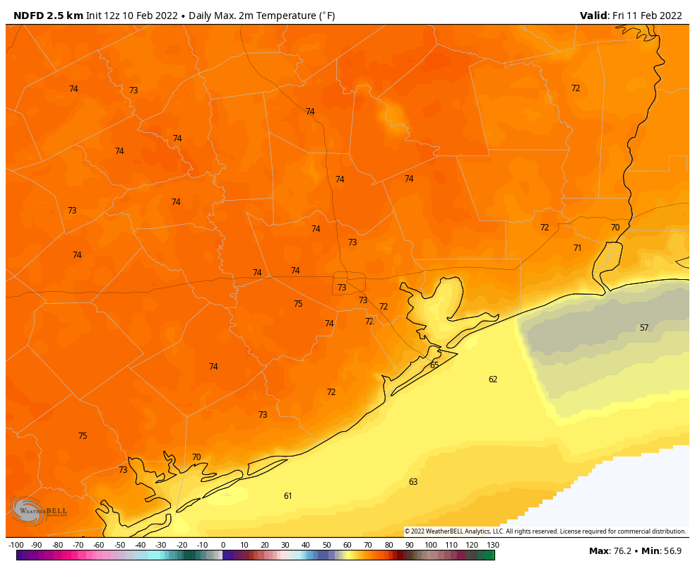
High temperatures on Friday could be the region’s warmest since mid-January. (Weather Bell)

Friday

As temperatures on Friday morning fall to near dewpoints, a few areas of light fog are possible. But then we should quickly see mostly sunny skies, and this will allow high temperatures to reach 70 to 75 degrees. Winds will again be fairly light. Overnight lows may only drop to around 50 degrees in Houston.

Saturday

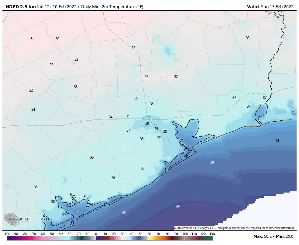
Unfortunately, after the entire work week saw sunny and sedate weather, we’ve got a front to deal with on Saturday, likely before noon. Effectively this means that areas inland of Highway 59/Interstate 69 may only warm into the 50s before the front’s arrival, and coastal areas the low 60s. Some light rain is possible with the front, especially nearer the coast where more moisture is available. Still, any showers will probably be briefly lived. Winds should gust to 20 to 25 mph on Saturday afternoon, in the front’s wake. As drier air moves in Saturday afternoon, skies should clear out during the late afternoon or evening hours. Overnight lows probably will drop into the upper 30s in Houston, with a light freeze possible for areas far north and west of the city.

Sunday morning will be quite chilly across the region. (Weather Bell)

Sunday

This should be a fine winter day, with relatively light winds, sunshine, and highs in the upper 50s to 60 degrees. Sunday night should be a degree or two warmer than Saturday night.

Next week

We’ll see a warming trend, with temperatures rebounding to 70 degrees by Tuesday. Then we’ll see a pattern change as clouds begin to build and rain chances return. This will happen as the atmosphere sees a series of disturbances rotated through, and moisture levels start to increase. We’re not looking at anything crazy, I don’t think, with probably 0.25 to 0.75 inch of rain for most. I’d pencil in our next front for Thursday, which will perhaps knock lows back into the low 40s, give or take.

Welcome to the spectacular sunshine show

Houston’s weather on Tuesday was spectacular, and there’s more of it ahead. We’ll continue to see sunny skies and mild winter temperatures until Saturday, when a front blows through. And then, shortly after this, we’ll see more sunshine and fantastic winter weather.

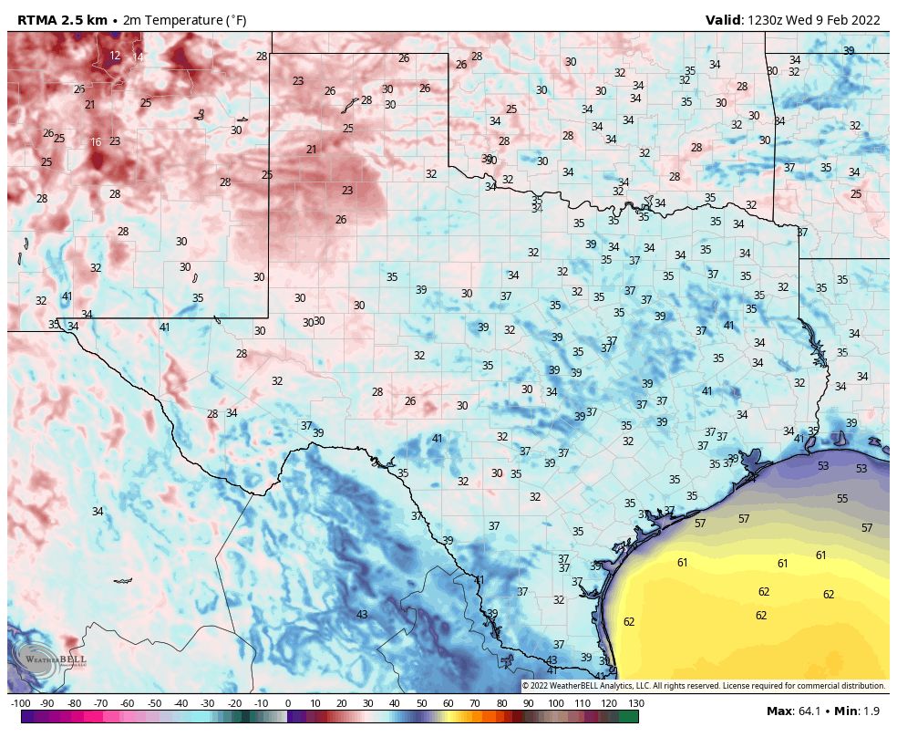
It is a cold February morning across the Lone Star State. (Weather Bell)

Wednesday

Most of the region is seeing lows in the upper 30s this morning. But with light southerly and westerly winds, and abundant sunshine, we should warm nicely to about 70 degrees this afternoon. Low temperatures overnight should be a few degrees warmer than Tuesday night, with much of Houston settling into the low 40s.

Thursday and Friday

The spectacular sunshine show continues, as does a slow warming trend. Both of these days should see highs of around 70 degrees, but overnight lows will creep up into the mid-40s by Friday morning, and perhaps around 50 degrees by Saturday morning. Winds both days should be light out of the south or southwest.

Saturday

There’s finally some agreement among the models in a frontal passage on Saturday around noon, or during the morning hours. For inland locations, then, highs may top out in the 50s, while coastal areas hit 60 degrees before the front arrives. Most likely this will be a dry passage, as the air simply won’t be holding enough moisture to really generate much in the way of rainfall. Winds will be noticeable, from the north, with the front’s passage. Expect gusts of 20 to 25 mph during the afternoon and evening hours. Lows Saturday night will probably drop into the upper 30s for Houston, with slightly warmer conditions along the coast.

Sunday

This should be a fine, sunny winter day with highs in the mid-50s. Winds should not be too much of a factor. Expect lows on Sunday night to be a degree or two warmer than Saturday night.

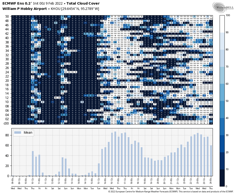
The “0”s in the chart above represent ensemble forecasts for zero cloud cover for Houston. Which is to say, expect ample sunshine for the next week. (Weather Bell)

Next week

Another week, with more sunshine, is likely. Houston will probably warm back to around 70 degrees on Wednesday before another front brings a decent chance of rain seven or eight days from now.

Sunny, cool, and dry weather to continue for awhile

Houston will continue to see splendid winter weather for awhile, with no major temperature or precipitation concerns. Instead, we’ll see a sustained stretch of sunny days, with moderate days and cool nights. Enjoy!

Tuesday

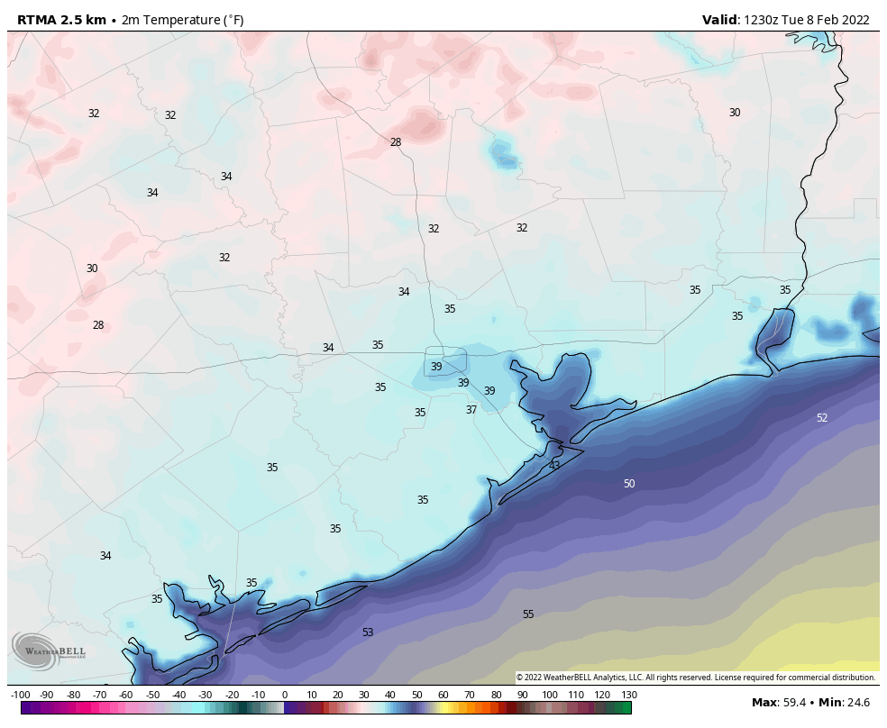
It’s cold out there this morning, but as light winds shift to come from the south later today, we’ll see high temperatures nudge up to the mid-60s beneath sunny skies. This should also help to moderate low temperatures a bit tonight, probably keeping most of the metro area at 40 degrees, or above.

Tuesday’s low temperatures, shown above just before sunrise, should be the coldest morning for the rest of this week. (Weather Bell)

Wednesday, Thursday, and Friday

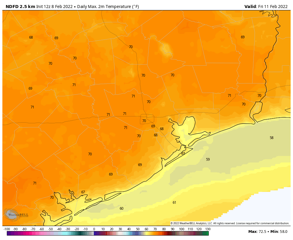
Overall, a fairly cool and dry air mass should remain in place over South Texas. Highs will generally be in the upper 60s on these days, with light southerly and southwesterly winds. Overnight lows will generally be in the 40s, although by Friday night they may only drop to around 50 degrees in Houston. Dewpoints will remain comfortably dry. Skies will be sunny, with nary a chance of rain. This is great weather for picnics, field trips, outdoor classrooms, or anything else out of doors.

Much of the area may see highs of 70 degrees by Friday. (Weather Bell)

Saturday and Sunday

The weekend forecast is coming a little bit better into focus, although there are still some questions about the details. In the big picture, a fairly strong cold front is likely to move through Houston during the daytime, perhaps after noon. So it’s likely that most parts of the region will see a moderately warm morning, and then have things cool off with the frontal passage. Some brief, light rain is possible during Saturday along with the front’s passage, but I think that’s still very much an open question. Winds will probably be breezy on Saturday night, perhaps gusting to around 20 mph, with temperatures dropping to around 40 degrees in Houston. Highs on Sunday should be in the 50s, with mostly sunny skies and a northerly breeze.

Next week

After a chilly start, I think we’ll see a more robust warm up next week with highs returning to the 70s. Widespread rain chances return to the forecast sometime after Monday as well.