Breezy but not too chilly after last night’s cold front

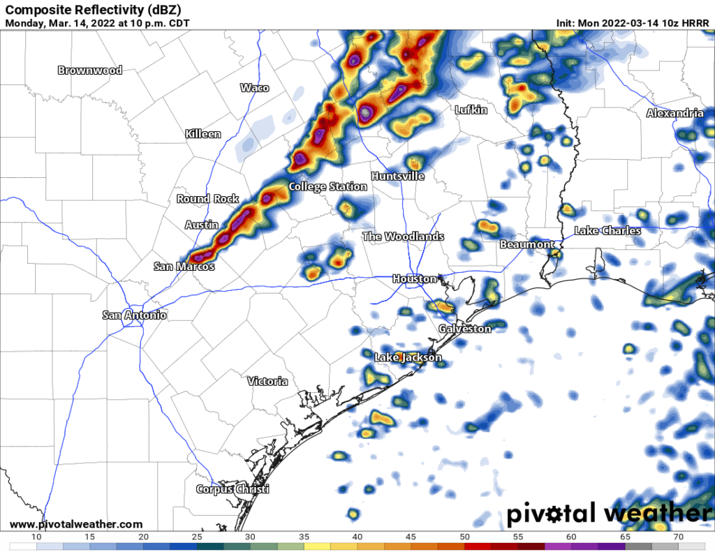
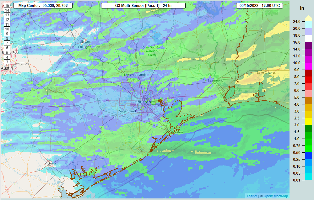
Well, we did not see any real severe weather in the Houston area last night, though there were a few hail reports north of our area. Some folks ended up doing well with rainfall, with over an inch in far western Montgomery County and northern Waller County, as well as near Santa Fe to the south.

Rainfall from last night’s storms was over a half inch south of Houston and in spots north of Houston. A few isolated spots saw over an inch of rain. (NOAA NSSL)

With the front through, we’re on to some very, very nice weather for the middle of the week.

Today

Most folks will see sunshine for most of the day today. The exception to this may be north and east of about Kingwood, where some partial cloud cover could nudge in for a time on the backside of a departing storm in the upper atmosphere. Those of us staying sunny all day will likely see high temperatures into the lower or middle 70s, while those with clouds may end up a couple degrees cooler. You’ll definitely notice a bit of a breeze today.

Wind gusts of 20 to 25 mph will be possible throughout the day, nothing serious but definitely noticeable. Mild temperatures will make it not feel too bad, however. (Pivotal Weather)

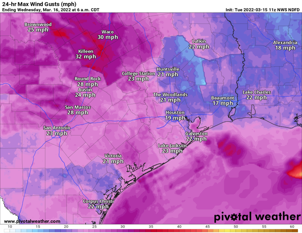
While not too strong, it will be a prevalent north wind gusting at times to 20 mph inland and 25 mph or so over the water and at the coast.

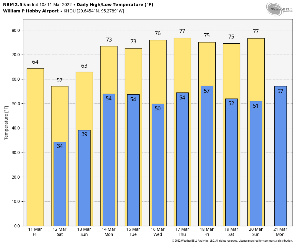
No doubt, it will be a sweet escape for those you heading to see Gwen Stefani tonight at the Houston Livestock Show & Rodeo. No weather issues of note, and it will be pleasant. Look for about 70 degrees as you arrive, cooling into the low 60s by the time you’re heading home.

Wednesday

Stunning. Sunshine, light winds, and temperatures warming from the 40s to around 50 in the morning to the mid-70s in the afternoon.

Thursday & Friday

After a gorgeous Wednesday, Thursday will mark our transition day. Look for a nice start to the day, with generally some 50s. But I would expect to see clouds filling in through the day, a bit of a gusty onshore breeze developing, and even a few light showers around. Despite that, look for highs to near 80 degrees in much of the area.

Our next chance at 80 degrees should come Thursday before a slightly cooler period later Friday and Saturday. (Pivotal Weather)

Humidity will gradually increase through the day as well. Our next front on Friday morning looks as if it will lack some of the punch that we got from last night’s front. Still, a few heavier showers or even a thunderstorm will be possible before about 9 AM Friday as the front crosses our area. We should then open up to sunshine and a breezy north wind again. Look for temperatures in the upper-50s to around 60 on Friday morning, easily warming to near 70 or a bit better with Friday afternoon’s sunshine.

Weekend

We’re still a few days away, but it really looks like we’re going to hit the jackpot this weekend. Expect sunshine and just a few clouds at times. Morning lows will be in the 40s and 50s and daytime highs will generally be in the 70s, slightly warmer on Sunday than Saturday. Fingers crossed this holds.

Preview of next week

It appears that we’re primed for another cold front, probably on Tuesday. This one is showing some signals in the models of being a bit more robust. We’re still several days out, but the expectation would be shower/isolated strong storm chances and increasing humidity Monday, a period of potentially heavier storms on Tuesday, and then a pleasant midweek. We’ll keep you posted.

A bit of a topsy-turvy week ahead for Houston

Good morning! I’ve got you covered this week, so Eric can enjoy some time with his family.

Well, if you could look past the cold, it sure was a nice weekend. Certainly Sunday was pleasant. We officially registered a freeze in Houston with lows of 32° at Bush Airport on both Saturday and Sunday mornings. Here’s a fun fact about that: This is the latest into the “winter” that Houston has officially registered a freeze since March 15, 1999! Our last freeze in 2021 occurred on February 20th. We got to March 6th in 2019. So this was some impressive cold for this late in the season. That should be it for freeze risk in most of the area this winter. Over the next 2 weeks, there’s nothing too impressive looking, though I don’t think we’re done with cool weather just yet. This week will feature a little of late winter and some definite signs of spring as well.

Today

We have another cold front on the way late today. This one won’t have nearly as much cold air with it, but it will have some oomph behind it, which should lead to at least some scattered showers and storms. The timing right now appears to focused in the evening hours, although there are already a few showers around this morning. Although the downpours or storms should be very hit or miss, have an umbrella at the ready today. We will probably see a more solid line of showers and storms with the front itself overnight. Those storms could be noisy for a short time.

A 10 PM Monday “forecast radar” from the HRRR model shows a handful of isolated storms ahead of the main line near College Station. That would arrive in Houston around or after midnight. (Pivotal Weather)

While the storms today will be fairly isolated ahead of the front, any of them will be capable of becoming strong to severe with gusty winds and/or hail this afternoon or evening. Most people won’t see severe weather, but a few places may.

A “slight” risk of severe weather (Level 2/5) is shown well north of the Houston area, while most of our area is in a marginal risk (1/5). Today, this means severe weather is possible but not necessarily likely. (NOAA)

Outside of showers, look for clouds, some sun, and high temperatures in the 70s today. Winds will also be up a bit today, out of the south at 15 mph or so, gusty along the coast.

Besides a chance of storms, Sam Hunt is on the menu tonight at the Houston Livestock Show & Rodeo. The good news is that any rain probably won’t last long, call it maybe an hour at most. But the bad news is that there is definitely a chance of some lightning in the area during the entirety of the evening. Most of that may occur either while you’re inside for the show or after you’ve arrived back home. Certainly the main line of storms with the front is expected after Midnight. Either way, prepare for at least a chance of showers or storms, and expect generally mild weather with 70s leading up to showtime and upper 60s after. If the front is faster and it rains more, you could see upper-50s or low-60s, so maybe a hoodie would be a reasonable accessory to have on hand for when you exit.

Tuesday and Wednesday

I think tomorrow may start a bit sluggish with some clouds around, especially north of I-10. Look for temps in the 50s on Tuesday morning. Those clouds to the north may keep temperatures from getting much past the low to mid-60s tomorrow, particularly if they linger into afternoon. But areas south of Houston, with fewer clouds should warm to near 70 degrees or a bit better on Tuesday afternoon. It will be a bit breezy tomorrow, with north or northwest winds gusting over 20 mph.

Wednesday looks spectacular. It will start a little cooler, with 40s or low-50s in the morning followed by sunshine and highs in the mid-70s at least on Wednesday afternoon.

Thursday and Friday

Onshore flow resumes on Thursday, which will kick up some humidity, clouds, and slight shower chances. Look for 50s in the morning, warming close to 80 degrees by afternoon. Pencil in the next front on Friday afternoon, with a chance of showers and storms. Morning lows Friday will only be in the 60s, warming into the 70s ahead of the afternoon front. More on this tomorrow.

Weekend outlook

Both weekend days look outstanding right now. Expect sunshine both Saturday and Sunday, with generally light to moderate winds. Morning lows will be in the 40s and 50s. Afternoon highs should be in the 70s.

Look for a warm up early next week, perhaps followed by another front on Tuesday or Wednesday.

A strong front will plunge Houston back into winter-like weather for a brief period this weekend

A strong cold front will cross our region this morning, bringing very cold and blustery conditions to our area through the weekend. However, much fairer weather is on tap for much of next week, with Spring Break for most Houston-area students feeling quite a bit like spring, lots of days in the 70s, and a fair amount of sunshine.

A comparison of temperatures at 11 am today (left) and 7 pm CT.

Friday

The front is a little bit ahead of schedule, having already reached College Station and pushing quickly toward Houston. It should reach the city during the mid- or late-morning hours, and will likely be near or off the coast by around Noon. Once the front passes, winds will pick up pretty quickly out of the north, and temperatures will start to plunge. Winds should peak overnight, gusting to 35 mph or even higher. For most inland areas, the front’s passage should be a fairly dry one, in terms of rainfall, but there’s enough moisture on the coastal side of Highway 59/Interstate 69 to expect some shower activity this afternoon as the front passes and in its immediate wake. Some coastal areas could pick up as much as an inch of rain before sunset. Temperatures tonight will drop to below freezing for some inland areas, and possibly parts of Houston itself, as skies clear allowing for optimal cooling.

If you’re heading out to the rodeo to see Bun B’s H-Town Takeover, please dress warmly. Temperatures will be in the upper 40s this evening. And while I don’t think rainfall will be an issue, winds will be blowing pretty good through the area at this time, making for rather unpleasant conditions outdoors. Temperatures will drop into the low 40s after the show, with plenty of wind still out there.

Forecast low temperature for Saturday morning in Houston. (Weather Bell)

Saturday

The first half of the weekend will bring brilliant blue skies into the forecast, but with a cold northerly flow highs will only get into the mid-50s. While northerly winds will have died back some, we can still expect to see some gusts of 15 to 25 mph. Expect another chilly night in the 30s for most of the area, although lows probably will be a couple of degrees warmer than Friday night.

Sunday

Don’t forget to spring forward an hour this morning for Daylight Saving Time. This should be a mostly sunny day, with highs in the 60s. As winds shift to come from the southeast, we can probably expect clouds to develop Sunday night, and temperatures to moderate quite a bit into the mid-50s.

Most of next week looks pretty darn nice for Houston. (Weather Bell)

Next week

If you’re taking some time off for Spring Break next week, but staying in the Houston metro area, you’re in luck. Monday will probably be gray, with lot of clouds and perhaps a smattering of rain showers, but after that a weak front should put the region’s weather back on track. Look for highs in the 70s, nights in the 50s, and a fair amount of sunshine for the rest of the work week.

After a splendid day today, a strong cold front arrives Friday

Congratulations, Houston. You’ve made it to the one day this week that will have truly spectacular weather, with mostly sunny skies and highs in the 70s. A strong cold front will push into the region on Friday, of course, bringing much chillier conditions back into the picture. However, beyond this, overall nice conditions look to be in store for Spring Break, with highs mostly in the 70s next week and plenty of sunshine.

Thursday’s highs will be in the low 70s, with plenty of sunshine. (Weather Bell)

Thursday

As we’ve been saying for awhile, today will be splendid for outdoor activities. Winds should be fairly light, out of the south, and highs will warm into the low 70s for most areas with mostly sunny skies. As moisture levels come up some this afternoon and evening, we’ll start to see the development of some clouds overnight, and this should help to ensure overnight lows do not drop below 50 degrees for most of our region.

If you’re making the trek out to the Houston Rodeo this evening to see Journey, your migration there should be a smooth sojourn. Temperatures this evening should be in the low 60s, with light winds. Post-show temperatures will be in the mid- to upper-50s, so pretty mild weather for this time of year. Some light showers may develop overnight, but I don’t think they’ll do so until well after the rodeo closes.

Friday

Some light showers will be possible on Friday morning, as moisture surges inland ahead of the cold front. Skies, otherwise, will be mostly cloudy with temperatures likely pushing into the upper 60s. The aforementioned front is on track to push into northwest areas of the region during late hours of the morning, and probably will reach the central part of Houston during the afternoon, and the coast around sunset, give or take a few hours. The front will bring sharply colder air, and winds will blow out of the north at 20 to 25 mph, with higher gusts. As skies clear out, expect temperatures to plunge into the 30s on Friday night, with parts of the metro area seeing a freeze. Just how much of Houston sees a freeze depends on several factors, so it’s impossible to pinpoint a freeze line just yet (see forecast map for the best guess).

Low temperature forecast for Saturday morning in Houston. (Weather Bell)

Saturday and Sunday

Winds will still be blowing out of the north on Saturday morning, but they won’t be quite as strong as Friday night. Despite sunny skies, highs will only get into the 50s, with another chilly night in store, as lows drop into the 30s. Sunday should be mostly sunny, with highs in the 60s.

Next week

Monday will warm up quite a bit, with highs in the mid-70s, in response to a southerly flow. This will help to increase cloud cover. However, a weak front should arrive Monday night, or thereabouts, and this will help bring mostly sunny skies and somewhat drier air back into the region. As a result, most of the rest of the week probably will see highs in the 70s, lows in the 50s, and a fair amount of sunshine. Enjoy!