A fantastic Friday will probably transition to a blustery Saturday

Despite the noisy storms early Thursday, we were rewarded with just a delightful Thursday evening and now a cool, pleasant Friday morning. Today looks great, but tonight may get noisy again, so mentally prepare now. But after some lingering showers Saturday morning, the rest of the weekend looks pretty great. And if you’re riding in the Texas MS 150, there’s all kinds of mixed news for you. Prepare those leg muscles.

Today

Any low clouds or patchy fog west of Houston should clear quickly this morning. Then, just spectacular. Sunshine, tolerable humidity, and highs in the 80s. Look for some clouds to begin to increase later today. Storms are not expected before evening in the Houston area at this point.

Tonight

It all changes after sunset. We expect a pretty well organized line of thunderstorms to develop across the I-35 corridor, somewhat like we saw on Wednesday evening. That line of storms is expected to plow south and east toward our region after 7 PM.

Convenient graphic from the National Weather Service Houston office showing probable timing of storms, along with the risk of severe weather. Most of the Houston area is under a “Slight” (2/5) risk, with strong winds being the primary concern. (NWS Houston)

For College Station, it may arrive as early as 5 to 7 PM, moving south and east quickly into the Houston area after 8 to 9 PM. The SPC has us in a “slight” risk of severe weather (level 2 of 5), with parts of the Brazos Valley in the “enhanced” risk (level 3 of 5). We expect a well defined line of strong to locally severe storms with lightning, thunder, heavy rain, and gusty winds (some chance of hail in the Brazos Valley). The line should weaken some as it approaches Houston. Once that initial line moves through, additional showers and rumbles of thunder (not severe) would continue into very early Saturday morning before ending after sunrise.

Rain totals should be a half-inch or less in most of the area, with some chance for higher amounts northwest of Houston and well south toward Matagorda Bay. (Pivotal Weather)

All in all we expect roughly a half-inch of rain or less, with some places seeing perhaps a bit more, mainly well northwest or well south of the city. Temperatures will fall into the upper-50s or low-60s.

Saturday

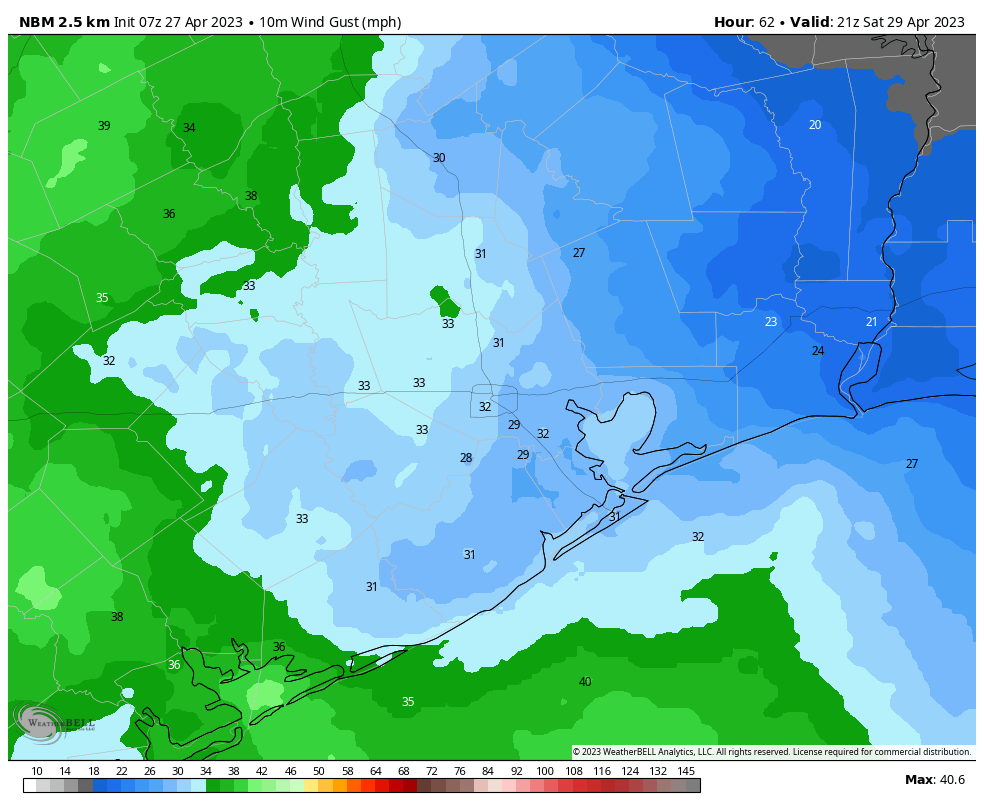
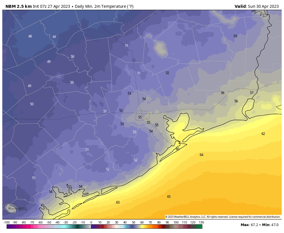
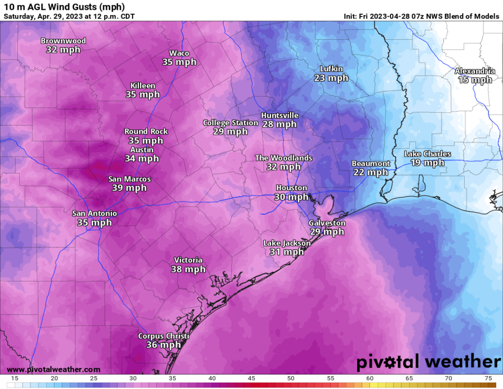
Any rain should clear early. We’ll probably hang onto the clouds for a few hours Saturday, but by midday the sun should be out. Saturday is going to be a bit of an odd duck for the end of April. It may feel a bit more like late winter than late spring. We’ll see temperatures probably in the 60s for most places, maybe low-70s with enough sun. Normally we see low-80s this time of year. Additionally, offshore winds are going to be cranking, around 20 to 25 mph with some higher gusts. Not quite a true ‘norther but about as close as you can get this time of year. Saturday night will see widespread 50s, if not even some 40s in parts of the area.

Sunday

Sunday should be a nearly perfect spring day. We’ll have sunshine, lighter winds, comfortable humidity, and temperatures in the low-80s, almost spot on normal for this time of year.

Texas MS 150

Alright, so if you read the sections above you know there’s mixed news. If you’re riding in the MS 150, here is the quick rundown.

  • Comfortable humidity levels both days.
  • Cool temperatures Saturday, warm temperatures Sunday afternoon.
  • A wicked headwind Saturday, much less wind Sunday.

There’s no way to sugarcoat Saturday. The weather is going to be fantastic, but the wind is just going to be brutal. At times it may be more of a crosswind than a headwind, but it’s going to be coming out of the northwest or north-northwest sustained at 20 to 25 mph, with gusts to 30 or 35 mph, especially in exposed northwest facing ridges along the route.

Forecast wind gusts from the NWS Blend of Models on Saturday afternoon look strong, and they’ll be out of the northwest, making for a bit of a strenuous journey. (Pivotal Weather)

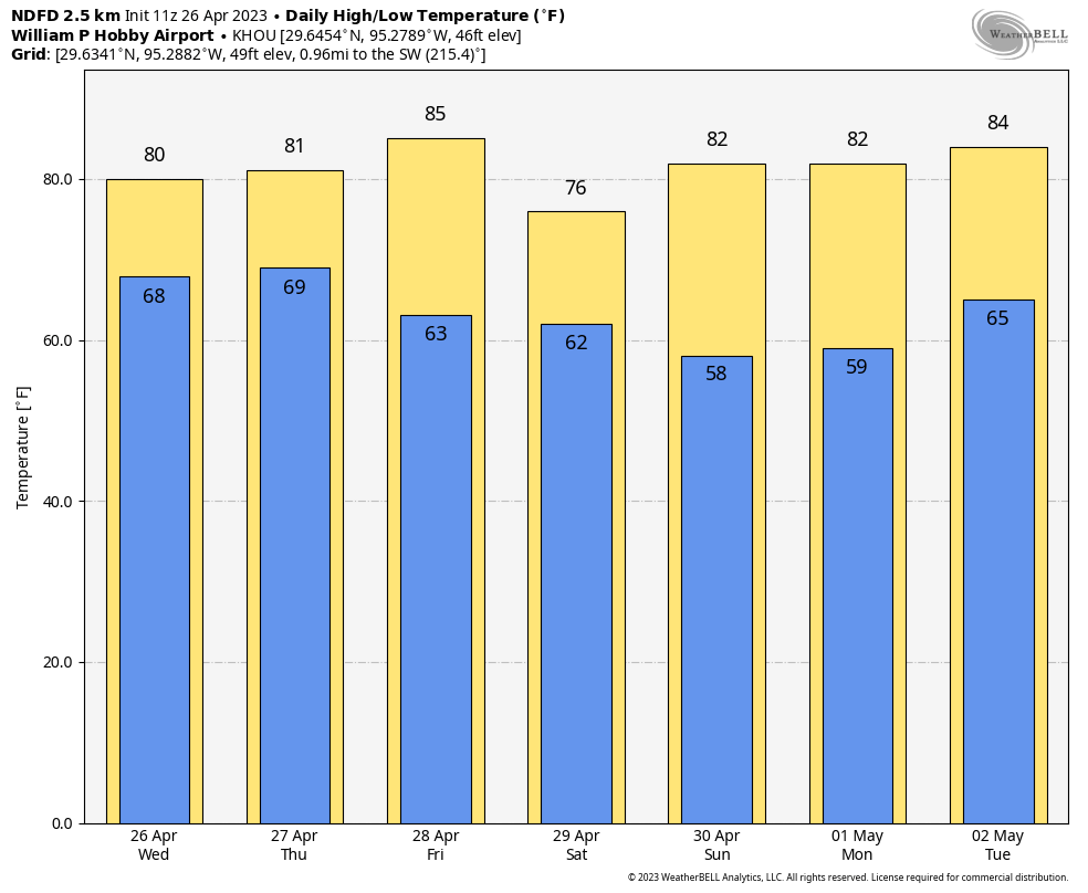
On Sunday, you’ll trade warmer temperatures for less wind. The morning won’t start that way, with temperatures likely in the 40s in La Grange. We’ll quickly warm through the 50s and 60s into the 70s by mid to late morning and eventually near 80 degrees in College Station. The good news is that wind will be much lighter, only about 5 to 10 mph out of the west.

Next week and beyond

There’s not too much notable about next week here in the Houston area, weather-wise. Expect gradually warming temperatures and increasing humidity levels through the week. We will probably level off with mid-80s for highs and mid to upper-60s for lows by Tuesday or Wednesday. Shower chances will return by then as well but right now no day looks to have particularly impressive rain chances.

The 8 to 14 day outlook from next weekend into the week of the 8th favors cool weather on both coasts, with Texas averaging out near normal. (NOAA)

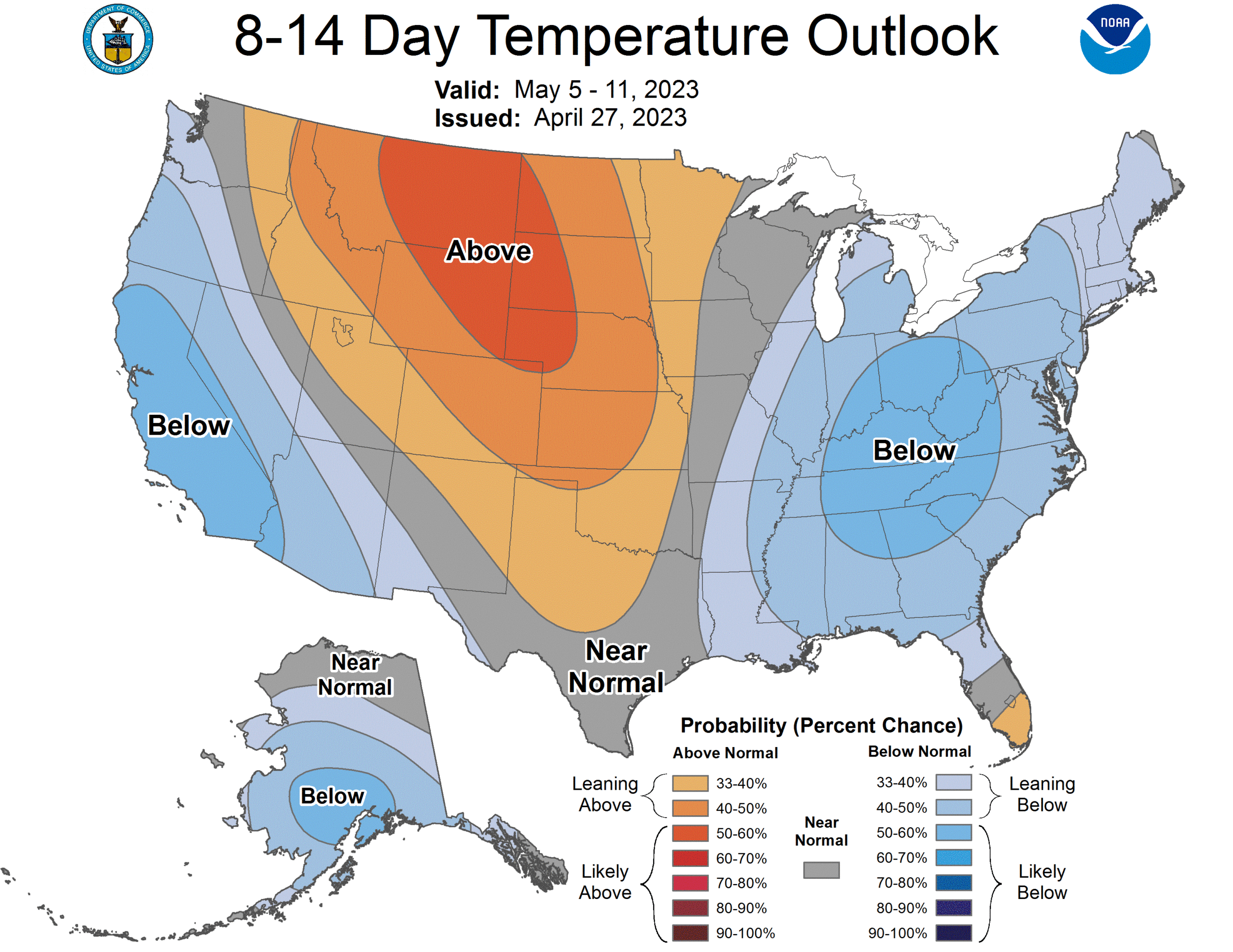
The big question right now will be whether or not we can eke out another late spring cool front sometime next weekend. The map above is the Climate Prediction Center’s 8 to 14 day outlook from Thursday. It shows a cool West and a cool East, with warm temperatures up in the northern Plains and Rockies. For Texas this time of year, these types of setups always cause us headaches. Can the cooler air get just enough oomph behind it to push south next weekend? Or will it just briefly, barely graze us and nudge off to the east quickly? If it can push through, expect another couple low humidity but mild days. If not, we’ll continue a more typical, humid late spring with rain chances. I’m optimistic we can squeeze a front through, but I also know that the odds in early May are not forever in our favor.

Following Thursday morning’s rumbles, another storm system may arrive in two days

As expected, a healthy round of storms is moving through the Houston area this morning. The show is mostly over for areas north of Interstate 10, but coastal areas may see on and off showers and thunderstorms for another couple of hours. We’ll have one more chance for storms early on Saturday before our weather quiets down for awhile.

Thursday

Most of the storms should be offshore by mid-morning, and by the afternoon hours we should see partially clearing skies as modestly drier northern air moves into the region. With at least some clouds holding on today, I think highs will probably only reach the upper 70s for most of Houston. Winds will remain fairly light, at 10 mph or so, mostly from the north. With clearing skies overnight, I think areas inland of Interstate 10 will probably at least briefly drop below 60 degrees tonight, with the coast remaining warmer.

Friday

This will be a fine, sunny day, with highs in the low- to mid-80s. Winds will be fairly light, out of the south. Conditions will start to turn more unsettled on Friday night as the next storm system and front approaches the area. As of now, I think any serious rainfall will probably hold off until after midnight, however. Lows on Friday night will drop into the low 60s.

Forecast for maximum wind gusts on Saturday afternoon. (Weather Bell)

Saturday

The good news is that we are starting to have a little bit of clarity on this weekend’s forecast. The bad news is that if you have plans on Saturday morning, and that includes participants in the BP MS-150 bike ride, there is the potential for storms. The jury is still out on whether we’re going to see a few isolated storms, or a more widespread system in association with the next cold front. However, we are increasingly confident that there will be at least some rain showers between the period of midnight and noon on Saturday. So rain, very likely. But severe weather or heavy rainfall? I can give you a solid maybe. Matt should have a better defined forecast for you tomorrow.

The front itself should move into the region during the pre-dawn hours, and likely push off the coast by or shortly after sunrise. This is going to produce fairly robust northwesterly winds, perhaps 15 mph with gusts of 25 mph or higher. So that’s going to be right in your face if you’re riding out toward La Grange on Saturday. Winds will probably be highest during the afternoon hours. Even with clearing skies on Saturday afternoon I expect highs to only reach about 70 degrees. Lows on Saturday night will drop into the mid-50s, so pretty chilly for the end of April.

A rough approximation of low temperatures for Sunday morning in Houston. (Weather)

Sunday

Sunday looks much nicer, with sunny skies, dry air, and highs of around 80 degrees. Lows on Sunday night will drop to around 60 degrees in Houston.

Next week

After several periods of unsettled weather, next week should bring calmer conditions back to Houston. We’re talking mostly highs in the 80s, perhaps approaching the upper-80s by weeks end. Lows will be in the 60s, approaching the 70s by week’s end. While there will be some clouds, I don’t see any major indications for storms or rainfall. At least not yet.

Storms are possible on Thursday morning, and the weekend forecast takes a U-turn into uncertainty

Good morning. Houston’s stormy, spring-like weather will continue with two systems affecting our weather in the days ahead. One comes early on Thursday, and the other and soon as late Friday night, but there remains a lot of uncertainty about the details. In the middle, we’ll also have some sunny weather and, occasionally, some drier air.

Wednesday

Today will bring mostly cloudy skies, with temperatures warming to about 80 degrees, and fairly muggy air. A very few, isolated light showers are possible today but overall I would peg rain chances at about 10 percent. This rather sedate weather should begin to change overnight, as a cold front approaches our region.

High temperatures will reach about 80 degrees on Wednesday. (Weather Bell)

The timing of all this remains a bit uncertain, but around 2 to 4 am on Thursday morning a line of storms should move into the area of College Station and then progress through the Houston area in the time frame of 4 to 8 am, and push off the coast by around 10 am-ish. The best chances for rainfall will be along and north of Interstate 10, but I think the entire metro area has a shot at receiving heavy rainfall. Overall accumulations will likely range from 0.25 to 1.5 inch of rain, and there is enough instability to produce hail and damaging winds. So we’re definitely looking at the potential for some late-night mischief in Houston.

Thursday

Obviously, depending on timing, the above conditions may impact the morning commute. You’ll want to check weather conditions before venturing out early on Thursday. After the front moves through, skies should clear during the afternoon hours, with temperatures reaching about 80 degrees. Lows will drop to around 60 degrees on Thursday night with mostly clear skies.

Friday

The onshore flow returns pretty quickly on Friday, so this will be a warm and somewhat humid day, with highs in the mid-80s. Skies will be mostly sunny. Lows on Friday night will drop into the mid-60s ahead of our next chance for storms.

Saturday

Well, the weekend forecast is unfortunately not all that clear as the models have diverged pretty hard on the the evolution of cold front and an associated upper level low pressure system. The bottom line is that This area of disturbed weather will approach our region on Friday night. After that? The GFS model pushes things through fairly quickly, and largely ends rain chances on Saturday morning. The European model, however, shows the upper level low getting hung up, keeping on and off rain chances going into Sunday morning.

The most likely outcome is a more fast-moving system, I believe, such that rains end on Saturday morning some time, with mostly cloudy skies and highs in the upper 70s on Saturday afternoon with northerly winds gusting up to about 25 mph. But we now have to account for the possibility of shower activity lingering on Saturday and Saturday night, a probability I would put at about 30 percent. Lows on Saturday night will also depend on how fast the aforementioned upper level low and front move, so right now I’ll ballpark them in the upper 50s.

Overall, Houston will continue to see spring-like temperatures into next week. (Weather Bell)

Sunday and beyond

Regardless of what happens on Saturday, we should see clearing skies on Sunday, and drier air. Look for highs in the upper 70s and another cool night before a warming trend early next week. We can probably expect highs in the mid-80s for most of next week, with the return of some clouds and pretty decent humidity by mid-week.

Slightly unsettled weather continues for Houston, with a few storms possible tonight

Good morning, and I hope this Tuesday is terrific for you. As for our what to expect from Mother Nature, Houston faces a pattern ahead with a little bit of unsettled weather, a little bit of warmer weather, and a little bit of fine, springtime weather. So it goes for April.

Tuesday

Temperatures are warmer this morning, having bottomed out at about 60 degrees for most of the region except for the coast where conditions are warmer. Humidity levels will continue to tick upward today as light winds turn easterly. Expect partly cloudy skies, with high temperatures ranging from the upper 70s to about 80 degrees. The more difficult question is rainfall. I would say the area has about a 30 percent chance of mostly light, scattered showers today.

As we get into this evening and the overnight hours, things get a little more interesting. There is plenty of moisture for the atmosphere to work with, but it’s not clear how much instability there will be. The bottom line, I think, is that there is about 30 or 40 percent chance of rain this evening and during the overnight hours. For most of us, this will be a non-event. But for a few neighborhoods, at least, there likely will be some fairly decent thunderstorms. So while the vast majority of the area is probably a 1 or a 2 on the excitable dog index, a few areas may be closer to a 6 or 7 later today and tonight.

If travels take you north on Wednesday, be wary of potential storms. (NOAA)

Wednesday

This day will be partly sunny and warmer, with highs in the low 80s. Rain chances aren’t zero, but they’re probably on the order of 10 to 20 percent. A word of warning if you’re traveling north on Interstate 35 Wednesday. A front will be moving through the state, and North Texas, including the Dallas-Fort Worth area, faces a healthy risk of thunderstorms and severe weather. I don’t think these storms will propagate all the way south to the Houston area, however. Lows on Wednesday night will be warm, dropping only into the upper 60s.

Thursday

A weak front pushes into Houston on Thursday morning, and we probably will see a round of showers with it. How much activity is going to occur is a little fuzzy, but my guess is that rain chances will be highest from about midnight to noon on Thursday, with clearing skies afterward and highs around 80 degrees. Lows Thursday night will drop to around 60 degrees.

Friday

This looks like a mostly sunny day, with highs popping up into the mid-80s, with slightly drier air.

Saturday

A second, stronger front looks set to arrive late Friday night or Saturday morning. The models are a bit unclear, but it is possible that a line of showers accompanies this front. In any case, this looks to clear out pretty quickly on Saturday morning. The story afterward is going to be northerly winds behind the front—something to definitely consider if you’re participating in the MS-150 bike ride. Highs should reach the mid-70s on Saturday, with mostly sunny skies. Winds could gust up to about 30 mph during the afternoon hours. With clear skies look for lows to drop into the 50s on Saturday night. There won’t be too many more of these chilly nights this season, so if that’s your jam, you best get jamming this weekend.

Behold: Saturday night will be one of the last chilly nights of this season. (Weather Bell)

Sunday

A pleasant, sunny day with highs likely in the low 80s. As the onshore flow returns, Sunday night will be a touch warmer, with lows perhaps around 60 degrees.

Next week

Most of next week should see highs somewhere in the 80s. It looks like the next chance of rain will return on Tuesday or Wednesday.