At the end of April, spring is holding on strong in Houston

After a surprisingly chilly Sunday, temperatures are fairly cold this morning across the state of Texas, with parts of the Houston dropping to about 50 degrees in the wake of a front. The region will see another decent cold snap this weekend as we reach the end of April. Knowing what is coming over the next five months, it’s nice to see April doing spring-like things.
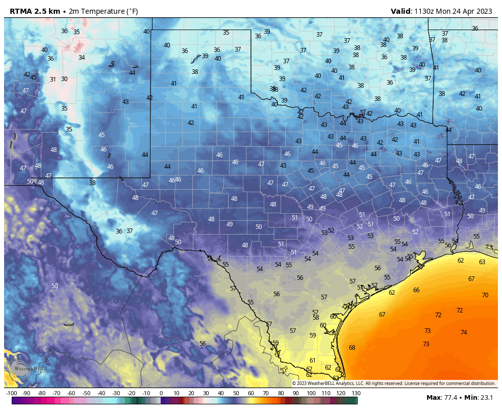
It’s a cold start to the final week of April in Texas. (Weather Bell)

Monday

We will see mostly cloudy skies today because, just above the surface, winds have already turned to come from offshore, pumping moisture back into the atmosphere. However, at the surface winds will remain from the northeast for the most part today, and this will keep our air reasonably dry, with highs in the low 70s. Temperatures tonight will only drop down to around 60 degrees with this warmer flow taking hold at the surface.

Tuesday

The aforementioned moisture in the atmosphere will combine with an atmospheric disturbance to produce a healthy chance of showers, and possibly some thunderstorms on Tuesday and Tuesday night. I think any rain will be fairly scattered during the daytime on Tuesday, with partly sunny skies helping to push daytime highs up to nearly 80 degrees. Showers may become more widespread Tuesday evening and overnight. While we cannot rule out a chance of severe weather in the Houston metro area, including hail and damaging winds, the more pronounced threat will be to our west, particularly along the Interstate 35 corridor. Lows on Tuesday night will only drop into the mid- to upper-60s.
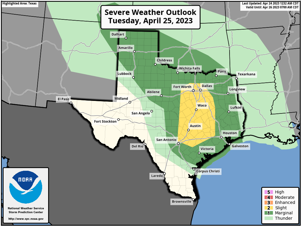
NOAA storm outlook for Tuesday and Tuesday night.

Wednesday

Never a dull day this week. Why? Because while Wednesday will start out with fairly calm weather and partly sunny weather, a front will be approaching from the west. Again we’ll not be in the bullseye for high storm chances—those will be off to the north this time—but we probably can expect some showers and thunderstorms on Wednesday night. Expect daytime highs in the low 80s, with overnight temperatures in the 60s.

Thursday

After any showers associated with the front clear during the morning hours, we’ll probably see a partly sunny day, with a smidgeon of drier air, and highs in he upper 70s.

Friday

Thursday’s front will be short-lived, so look for highs to push back up into the lower 80s, with nighttime temperatures in the low 60s. Another, slightly stronger, front looks to push in on Friday night setting the stage for a cooler weekend.

Saturday and Sunday

The weekend will feel distinctly spring-like even though we’re coming to the end of April. In the wake of the front, look for highs in the mid-70s on Saturday, likely with clearing skies. Lows Saturday night will probably bottom out in the mid-50s, and Sunday will top out at around 80 degrees with sunny skies.

If you’re riding the MS-150 bike event out of Houston this weekend, the one concern is winds. It’s too early to be certain, but I think there probably will be decently strong winds from the north on Saturday, perhaps gusting to 25 mph. Similar, but less gusty winds, will be possible on Sunday. Fortunately the likelihood of rain or any storms this weekend is very low at this point.

Next week

The start of next week should see a warming trend, with temperatures eventually getting into the mid- to upper-80s, probably. Then? Perhaps some sort of front to cool things down. We’ll see.

Saturday remains the best of the weekend, while Sunday may be sloppy especially to the south

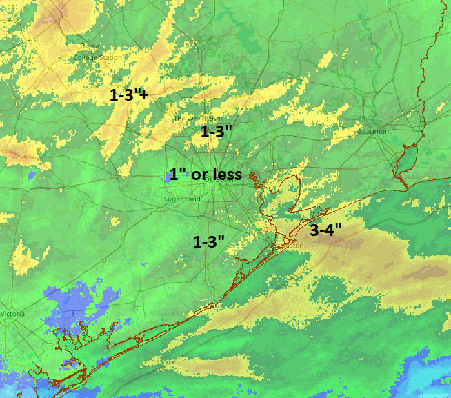
Good morning. It was a bit of a noisy night last night across much of the area at various times. Rain totals were quite variable. Most of the inner part of Houston saw 1 inch or less of rain overnight. Northern Harris County north through Montgomery County saw 1-3 inches of rain. Coastal areas got hit by a second complex of storms and saw 1 to 3 inches south of Houston with up to nearly 4 inches in Galveston.

Radar-derived rain totals from overnight match up well with observed totals with most of Houston seeing 1″, give or take, while areas south and north each saw higher totals. Click the image to enlarge. (NOAA NSSL)

You can view more rain totals from the Harris County Flood Control website. While the night didn’t go exactly to plan, the end result was mostly in line with expectations and nearly everyone saw rain.

Rest of today

The atmosphere is pretty worked over after last night’s storms, so those will actually work to help us have a mostly decent day today. I am hopeful that we see some sunshine break out this morning from west to east. We’ll then possibly cloud up again heading into the afternoon as the cold front approaches. A few showers or an isolated thunderstorm will be possible as the front passes. But I think most areas will stay calm today. We should manage the 80s for highs this afternoon, with pretty high humidity. It’ll feel a little soupy.

Saturday

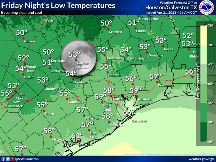
Everything continues to look great tomorrow. We expect sun, comfortable humidity, and temperatures warming from the 50s (or low-60s) well into the 70s.

A cool, calm night is expected tonight, with lowering humidity and temperatures. Lows will be generally in the 50s, with 60s on the coast. (NWS Houston)

Sunday

We’re continuing to watch a vigorous disturbance for Sunday that will likely pass comfortably south of Houston. That being said, rain chances are going to build up across the area, but especially south of the city during the afternoon. These breakdowns are approximate and if you fall “on a line,” don’t read into either too much.

For the City of Houston and points north: Expect clouds and some sun on Sunday. Morning lows will generally be in the 50s to near 60, and we will warm up in the mid-70s. Humidity will be a little higher Sunday but by no means oppressive. Showers are likely to break out during the afternoon hours, especially the closer you get to I-10 or highway 59/I-69. A thunderstorm can’t be completely ruled out either.

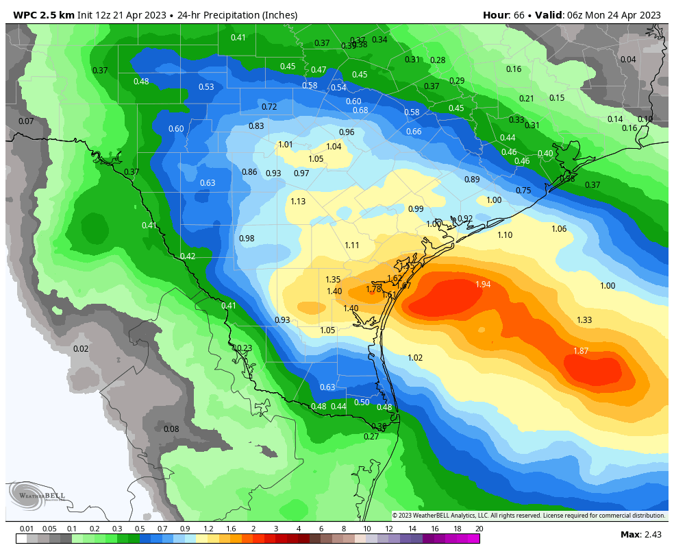
For places south of Houston: Expect mainly cloudy skies with showers and thunderstorms developing on Sunday afternoon. Chances for heavier rain and more widespread thunder will be close to Matagorda Bay. As you go north or up the coast from there, rain chances will gradually taper from widespread to “scattered.” Some of the storms could be strong to severe on Sunday, especially as you get closer to the Corpus Christi area.

Sunday’s rain totals will be 1 to 3 inches near Corpus Christi with probably a half-inch or less on average in the Houston area. But everyone will face at least a chance of rain and thunder. (Weather Bell)

Rain will be heavy as well with 1 to 3 inches possible south of Matagorda Bay. Anyway, the bottom line is if your travels take you south of Houston on Sunday, you’ll want to be aware of this. Outdoor plans in and around Houston will clearly be a bit hit or miss.

Monday

This looks like a calmer day with just a very slight chance of showers or a storm. Look for highs in the 70s and morning lows in the 50s and 60s.

Tuesday

Details on how Tuesday will play out are fuzzy, but it’s safe to say that rain chances are notably higher versus Monday. Expect at least scattered showers and storms. It will be warmer and more humid, with highs near 80 and lows in the 60s.

Wednesday

The atmosphere may need to recover from leg day on Tuesday, so rain chances look a bit lower here. We should temps into the 80s with some sun, while AM lows struggle to get much below 70 degrees.

Thursday

Cold front day? Shower and storm chances will increase again here, as we see a cold front approach the region. Again, it’s too soon to figure out details. But it appears we’re going to see scattered storms at the least. This should hopefully setup a nice weekend for the MS150 and any other events around the region. But, we still have a few days to watch things.

Reliant Guest Post: Preparation and Flexibility Ahead of Summer

Note: This is a guest post from our long-time sponsor Reliant. As part of our agreement, they will share messages like this once or twice a year. And just a word about Reliant—they’ve been sponsors of this site for more than five years, and really they’ve become great partners over that time. Last year, for example, they very much helped us put on the Fall Day event.

Hi, Space City Weather readers! Just like you, we are savoring the spring weather this week. As we all step outside to enjoy the best of Houston, here are a few helpful reminders to make sure your home is running as efficiently as possible.

Start your spring cleaning

Take this time to check your home for any improvements needed to enhance energy efficiency. Make sure your AC is in good condition and is working properly. Getting your AC system in good working order before summer hits is a little like getting your car serviced before a road trip, and it can save you money. Also, did you know that simply cleaning or replacing filters regularly can lower your system’s energy consumption by up to 15 percent?

Learn about your energy patterns via an app

Make sure you have the latest information on your family’s usage patterns with the Reliant app! It allows customers to easily manage accounts, monitor overall usage, pay bills, set up usage alerts, and more. Downloading it now will ensure you can fully sync it to your household devices like Google Nest, ahead of the summer heat.

Check out electricity plans for your lifestyle

Now is also a good time to review your electricity plan and make changes if needed. People use electricity in different ways and have different preferences, so we have options for everyone. Find the right one for you!

Our newest plan Reliant Flextra Credits brings together flexibility and extra credit. It includes free electricity on your two highest-usage days each week, up to eight days of free electricity per month, three $25 bill credits to use when you choose, and the benefit of 100% solar electricity with no panels required.

  • Flexibility: Customers on this plan automatically enjoy completely free electricity on their two highest-usage days each week – up to eight free days per monthly billing period. The plan adapts to each customer’s lifestyle, meaning you don’t need to plan your usage or adjust your habits.
  • Bill Credits: The Flextra Credits plan features a total of $75 in bill credits, powering peace of mind for customers when the unexpected arises. Three $25 bill credits can be applied to three separate monthly bills, when a little extra room is needed in the budget. You control when to apply each credit through the app, online, or by phone.
  • Transparency: The plan fully matches each customer’s electricity usage with solar renewable energy certificates, so you can support 100% solar-powered electricity – no panels required. The Reliant app provides dynamic overviews of your solar energy usage, positive solar impact, and carbon footprint reduction.

Reliant is here to help you with innovative products and services to meet your unique needs, backed by award-winning customer care and digital management tools. You can sign up for the Flextra Credits plan or learn about other offerings by visiting Reliant.com or calling 1-866-Reliant.

Swift moving thunderstorms may put a charge into Thursday night in the Houston area

The good news today is that Friday’s forecast may not be too bad at all. Yes, there will be rain chances tomorrow, but the worst of the weather should pass by early morning. The bad news is that tonight may feature midnight rain, staggered sleep, and an excitable dog index of at least eight out of ten.

Today

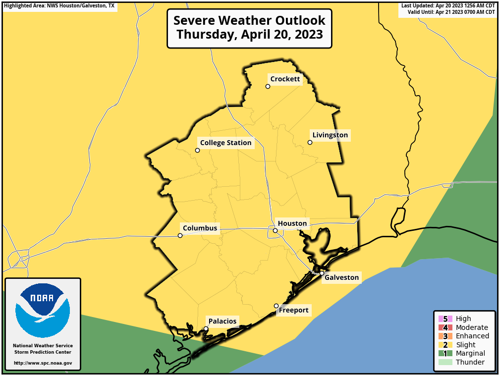
Today will be a bit challenging to pin down exactly. The morning looks fine. By midday, we should begin to see thunderstorms develop west of the Houston area, mainly on a line from College Station through Columbus. These storms will gradually become a bit stronger and slowly slide east, perhaps to Conroe or Huntsville south through Katy by late afternoon. By then, any storms could become borderline severe, with hail and gusty winds. Areas east of I-45 and along the coast may see little to nothing for most of today.

The entire area is under a “slight” risk (level 2/5) of severe weather today and tonight. (NOAA)

By evening, we’ll see scattered showers and storms pretty much along or northwest of Highway 59/I-69.

Thursday evening and overnight

Main message: Phase one of storms mainly north and west of Houston will begin winding down this evening. The second phase of storms should be widespread and hit most of the area with heavy rain, lots of thunder and lightning, and potentially strong, gusty winds in the overnight hours. It would be a good idea to have a way to receive weather warnings overnight, just to be safe.

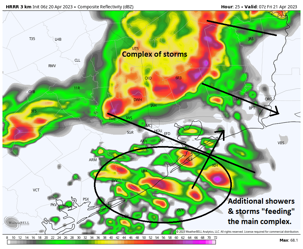
Details: Afternoon storms will also develop on Thursday out in Hill Country and along the I-35 corridor. That separate area of storms will likely congeal into a well-organized complex of storms that rushes south and east this evening. The bulk of that will pass along and north of I-10 around or after midnight. Additionally, new storms “feeding” the main complex will develop south of Houston and lift northward. This can be seen in the forecast radar from the HRRR model at 2 AM tonight. I annotated the two areas here.

Two areas of storms are likely to impact us overnight with many places seeing heavy rain, gusty winds, and a lot of lightning. A couple of these storms could become severe. (Weather Bell)

These types of setups are typically favorable to produce strong, gusty winds. Some of the storms developing to the south could become a bit severe as well, with hail or strong winds. Basically, all this adds up to a setup that is favorable to produce noisy weather in the overnight hours, probably beginning around or just before midnight north and west and then most of the rest of the areas between 12 and 3 AM. By 6 or 7 AM, most of the storms should be offshore.

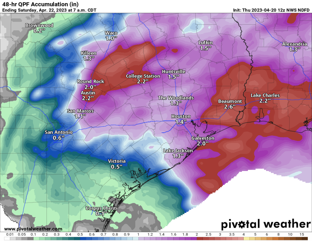
Rain totals of 1 to 2 inches will be likely across much of the area. Some places will see less (especially southwest of Houston), while others could see more, especially east, northwest, and north of Houston. (Pivotal Weather)

Rain totals will probably average 1 to 2 inches for much of the area. The exceptions to this may be southwest of Houston. The heaviest activity may miss north and east of there, so rain totals risk coming in under an inch for places like Fort Bend County back through Wharton. Northwest of Houston and east of I-45 could see slightly greater amounts, as this is where storms will probably be heaviest.

Friday

Showers and storms should race offshore in the early morning. Typically, the atmosphere is pretty worked over after an event like this, so while there will continue to be a chance of showers or even a thunderstorm as the cold front approaches in the afternoon, the risk of anything significant appears to be on the low side right now. Expect gradual clearing and highs in the 80s Friday if the sun can break out for a time.

Saturday

Definitely the pick of the weekend. We expect morning lows in the 50s or low-60s, sunshine, and afternoon highs in the upper-70s. Weather for Taylor or the Dynamo match versus Inter Miami looks great.

Sunday

The second half of the weekend is a much trickier proposition. Morning lows will be in the 50s or low-60s. Then, there will be two forecasts for Sunday: One will be north of I-10, and the other will be south of I-10. Keep in mind that this is meant to be a generalization, not an exact demarcation.

For folks north of I-10, you will likely see clouds and perhaps a little sunshine. There is a slight chance of showers in the afternoon, especially the closer you are to Houston. Highs will be in the low to mid-70s depending on how much sun can break through.

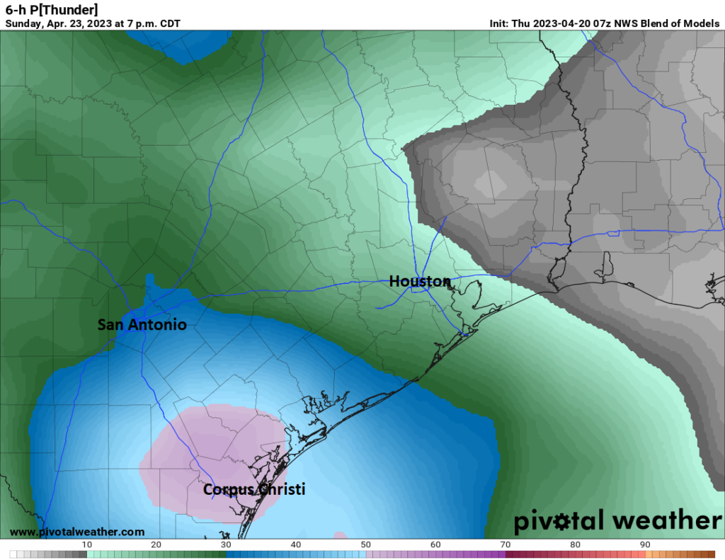
Those of you south of I-10 should see clouds thicken up with highs in the low-70s. Showers and thunderstorms are likely to develop during the afternoon, especially the closer you are to Matagorda Bay. Rain could be heavy at times.

The probability of thunder on Sunday afternoon is highest in the Corpus Christi area, according to the National Blend of Models. That said, chances are not zero in the Houston area. (Pivotal Weather)

I would caution that there’s still a fair bit of uncertainty on the specifics of Sunday’s forecast, so if you have plans, be they T-Swift or otherwise, check back in with us tomorrow for the latest.

Early next week

The front half of next week looks generally unsettled with a chance of showers, albeit a fairly low one Monday and Tuesday. There may be a better chance of showers or storms Wednesday. Highs will be in the 70s and 80s and lows generally in the 60s.

Late next week & MS 150 preview

Presumably, Wednesday’s storms will herald a cold front that should bring in cooler, drier air for late next week. This would mean highs in the 70s and lows in the 50s or low-60s, along with low humidity. What does this mean for next weekend’s MS 150 ride across southeast Texas?

Usually when we get fronts like this in late April, the cool air stays a day or two, and then onshore flow resumes and we’re back to warm and humid. This front may have a little more “oomph” behind it, so I might be willing to say that Saturday would continue to be pleasant, with highs in the upper-70s to near 80, sunshine, and comfortably low humidity. It’s far too early to speculate much on wind, but this type of pattern would probably produce a light east or northeast wind, so almost a tail wind for Saturday if you’re leaving from Houston. I would assume that winds would be out of the south and a bit stronger on Sunday, with slightly higher humidity and highs in the 80s. For now, rain chances look low, but I have to caution that it’s still early. We will keep you posted!