Stormy pattern will gradually shift to a sunnier one for our region

Good morning. After a wet weekend that left several area rivers and bayous near or over tops of their banks, and saturated area soils, our region will begin to transition to a somewhat drier pattern overall. However, a healthy chance of storms will remain today for areas along and west of Interstate 45 before our skies turn sunnier on Tuesday and then remain that way for most of the remainder of the week.

Monday

The problem for today is that our atmosphere remains fairly moist, and we’re not quite done with atmospheric disturbances. This should allow showers and thunderstorms to fire up southwest of Houston early this afternoon, and then lift northward into western and central parts of the city, before exiting to the north by around sunset. Most areas west of Interstate 45 will likely see around 0.5 inch of rain, which is totally manageable. But some areas could pick up 1 to 3 inches beneath stronger thunderstorms, and this may briefly back-up streets. For this reason, I’m going to keep a Stage 1 flood alert going for the western half of the Houston region, basically areas west of I-45.

Excessive rain outlook for Monday in Houston. (NOAA)

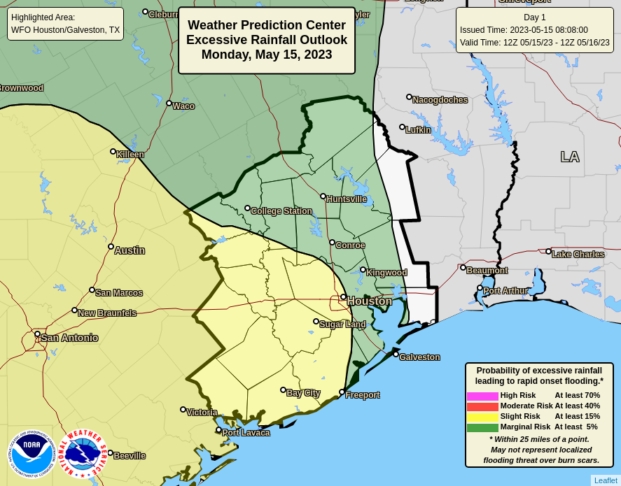
Skies will otherwise be mostly cloudy, and for most areas this should limit high temperatures in the mid-80s. Winds, outside of thunderstorms, will generally be light at about 5 mph out of the east. Low temperatures tonight will drop to around 70 degrees in Houston as rain chances recede to near zero.

Tuesday

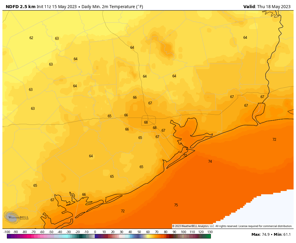
A weak cool front arrives on Monday night, and this will shift our winds to come from the west or northwest. Unfortunately, it will also provide a bit of instability that will help produce one more round of showers and thunderstorms on Tuesday. While I don’t expect these to be as widespread as the rain on Monday, I think there’s still a solid 30 to 50 percent chance of showers on Tuesday afternoon. Expect partly sunny skies with highs in the mid-80s. Lows on Tuesday night will drop to around 70 degrees.

Wednesday

Rain chances drop back to around 20 percent, with mostly sunny skies during the afternoon hours. Look for highs in the mid- to upper 80s during the afternoon and, for some inland areas, lows dropping into the mid- to upper 60s on Wednesday night. That is some May cold front action for you, Houston!

Low temperature forecast for Thursday morning. (Weather Bell)

Thursday and Friday

These should be a pair of mostly sunny days with highs in the upper 80s to 90 degrees. Lows will drop into the low 70s.

Saturday and Sunday

The weekend forecast is—dare I say it on a Monday morning, up in the air? There looks to be a second front coming this weekend, and while it’s too early to say for sure, I think there’s a decent chance it pushes all the way through Houston and off the coast on Saturday. This could bring some scattered showers with it. For now let’s ballpark partly sunny skies and highs in the upper 80s. If the front makes it, I wouldn’t rule out some lows in the mid-60s for most of the metro area early next week. We’ll see.

A soggy Mother’s Day is in store for Houston before the threat of heavy rainfall ends

Good morning. Alas we’re seeing an atmospheric disturbance slowly move northward through the region this morning, and it is driving a band a strong thunderstorms throughout the central part of the metro area. Given the ongoing abundance of low pressure and atmospheric moisture, we’re going to see one more day with conditions favorable for heavy rainfall today.

Areas in red are most at risk for heavy rainfall on Sunday. (NOAA)

Most of the region is likely to pick up and additional 0.5 to 2 inches of rainfall today, so we’re not concerned about significant flooding for most of the area. But we will see some areas with higher totals, and there definitely will be the potential for streets to briefly back up beneath strong and slow-moving thunderstorms. For this reason we are maintaining a Stage 1 flood alert through the afternoon hours in Houston. We expect the disturbance to continue moving north, and eventually pull away from the area this evening. Due to the clouds and persistent rainfall, high temperatures today likely will top out at about 80 degrees.

Rain chances will hang around after today, but they’re going to go down starting Monday, and the threat of heavy rainfall will drop accordingly. We should start to see the return of a fair amount of sunshine by Tuesday or Wednesday, with slightly drier air from a weak front.

Chance of heavy rain increases for this weekend, necessitating a Stage 1 flood alert

Good morning. As anticipated, a line of strong storms has developed to the west of Houston this morning, roughly from College Station all the way south to Corpus Christi. We expect these storms to continue to build slowly to the east, and into Houston later this morning and the afternoon hours. There remains a lot of uncertainty about how much punch these storms will have as they progress closer to, and into the Houston metro area. But we now have enough concerns about the potential for heavy rain to issue a Stage 1 flood alert out of concern for street flooding today and tonight.

The most problematic time for rainfall will be from the mid-morning hours today through the afternoon. However, at this time we can’t rule out the additional development of showers tonight, and on Sunday, as a series of disturbances plow through our moist atmosphere. Please check the radar before heading out, and if you have outdoor activities on the schedule for this weekend, have a back-up plan. And since it’s Mothers Day weekend, I know many of you do have plans.

Areas at risk for excessive rainfall on Saturday and Saturday night. (NOAA)

Overall, I expect most of the region to see 0.5 to 2 inches of rainfall this weekend, but areas west and southwest of Houston have a greater risk of heavy rainfall, and isolated areas may see 2 to 6 inches of rainfall. Due to the aforementioned uncertainty about this weekend’s weather, Matt and I will continue to keep an eye on things. We apologize to all the moms out there for the lousy weather this weekend.

Houston will be on the edge of decent rain chances this weekend, with drought relief for interior Texas

As promised, yesterday ended up being much, much calmer, giving us a chance to exhale and dry out a bit. Things are going to pick back up again as we head into the weekend — but probably not for everyone. We continue to see a pretty healthy split in the weekend outlook, with areas west of Houston more likely to see more rain than the Houston area itself. As a result, the National Weather Service issued a Flood Watch for areas southwest of Houston for the weekend.

A flood watch is in effect this weekend for Wharton, Jackson, Matagorda, and Colorado Counties west and south of Houston. (NOAA)

Those areas under the flood watch are the most likely areas to see multiple rounds of heavier rain this weekend. Areas not under a flood watch (which is most of Houston) are likely to see at least some showers this weekend, including the risk of some heavy rain. But it would most likely be manageable. That said, Eric and I will be monitoring the weather this weekend, and we’ll post an update or two if necessary or if things change, which I would caution is possible.

Today

Of the next several days, today looks calmest. Yes, there will probably be at least a few showers or storms around this afternoon in parts of the area. But those will probably be the exception, not the rule. Look for a good deal of clouds this morning, yielding to sunshine with highs well into the 80s, if not near 90 degrees.

Saturday & Sunday

I wanted to split these days up in the forecast to try and give you a better idea of what to expect each day, but the pattern over the state of Texas this weekend is far too chaotic for me to try and time anything out specifically.

Here’s the deal: If you have outdoor plans this weekend, have a backup plan indoors if needed. If your plans take you west of Houston (Austin, San Antonio, Hill Country, the Valley, you will likely run into thunderstorms at some point, including the chance of heavy rain, severe weather, and flooding. Be aware of what’s happening out that way and do your best to avoid flood prone areas if possible.

Rainfall this weekend should average an inch or less in the Houston area, with amounts as high as 4 to 8 inches out toward Austin, San Antonio, and in the Rio Grande Valley.

Total rain this weekend across Texas will be highest in the Rio Grande Valley through San Antonio, with high amounts into Hill Country as well. Exactly who sees the most rain is TBD. But these areas need it with widespread drought in west and central Texas.

For us in Houston, while we don’t want to be overconfident, it would appear that Saturday afternoon or evening may carry the highest risk of storms making their way into the metro area. Sunday should, should see slightly lower rain chances for Houston proper and the metro area. Both days will be warm and humid with highs in the mid-80s and lows in the 70s. Outside of any storms, we may see some sunshine. But clouds may be a bit more dominant this weekend.

Early next week

The weather pattern across Texas remains active next week, with scattered showers and storms possible. It may not rain every day, but there will at least be a chance of rain each day. We still look to see a weak “wind shift” front later Monday or Tuesday. Maybe we drop humidity a tick or two, but I wouldn’t expect much more than that. Temperatures will be generally in the mid to upper-80s by day and low-70s by night.

As noted, Eric and I will be watching the weather this weekend and update accordingly, if only to help everyone strategize their weekend plans. In the meantime, to the many moms that read our site, happy Mother’s Day!