Fairly typical June weather with a few storms, but a tropical disturbance may bring heavy rainfall early next week

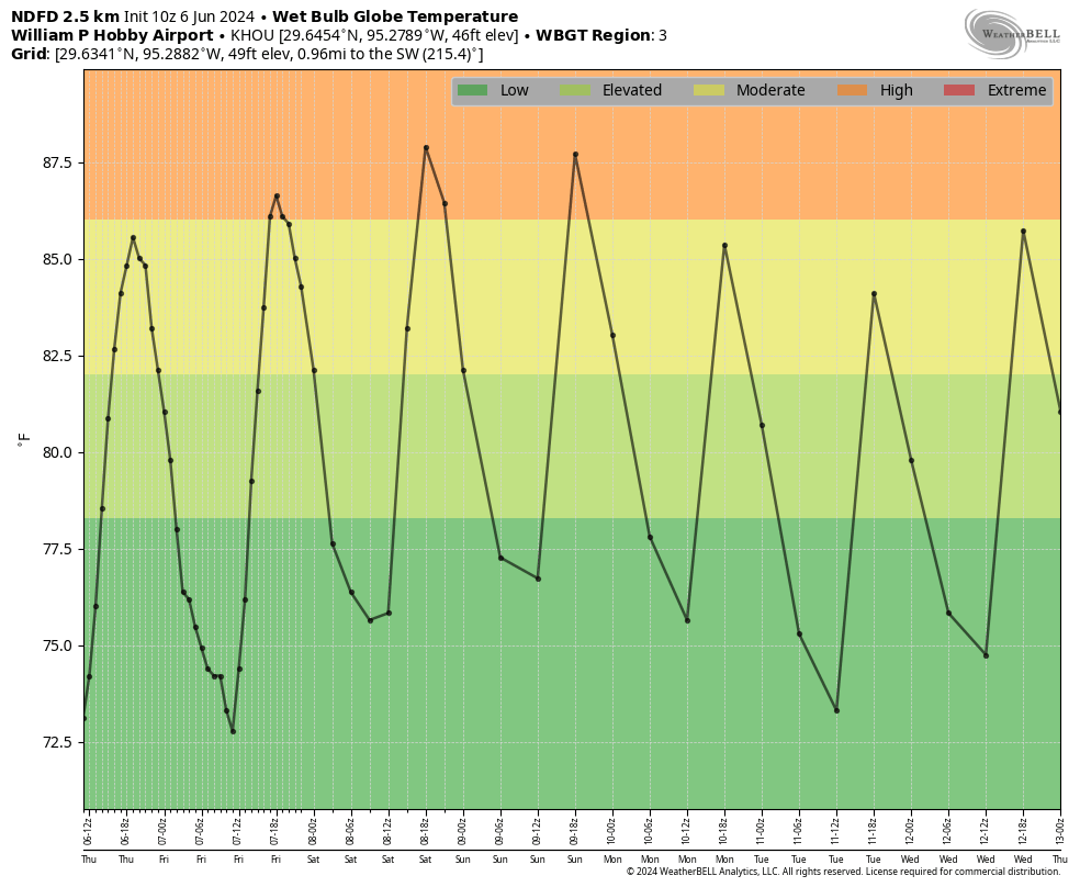
In brief: The early part of this week will see some storm chances, especially Tuesday. After that we’ll be mostly sunny and increasingly hot through the weekend. Some slightly lower humidity is also in the cards, a real blessing in June. Finally, we’re following the possibility of heavy rain next week as a tropical disturbance develops in the Gulf.

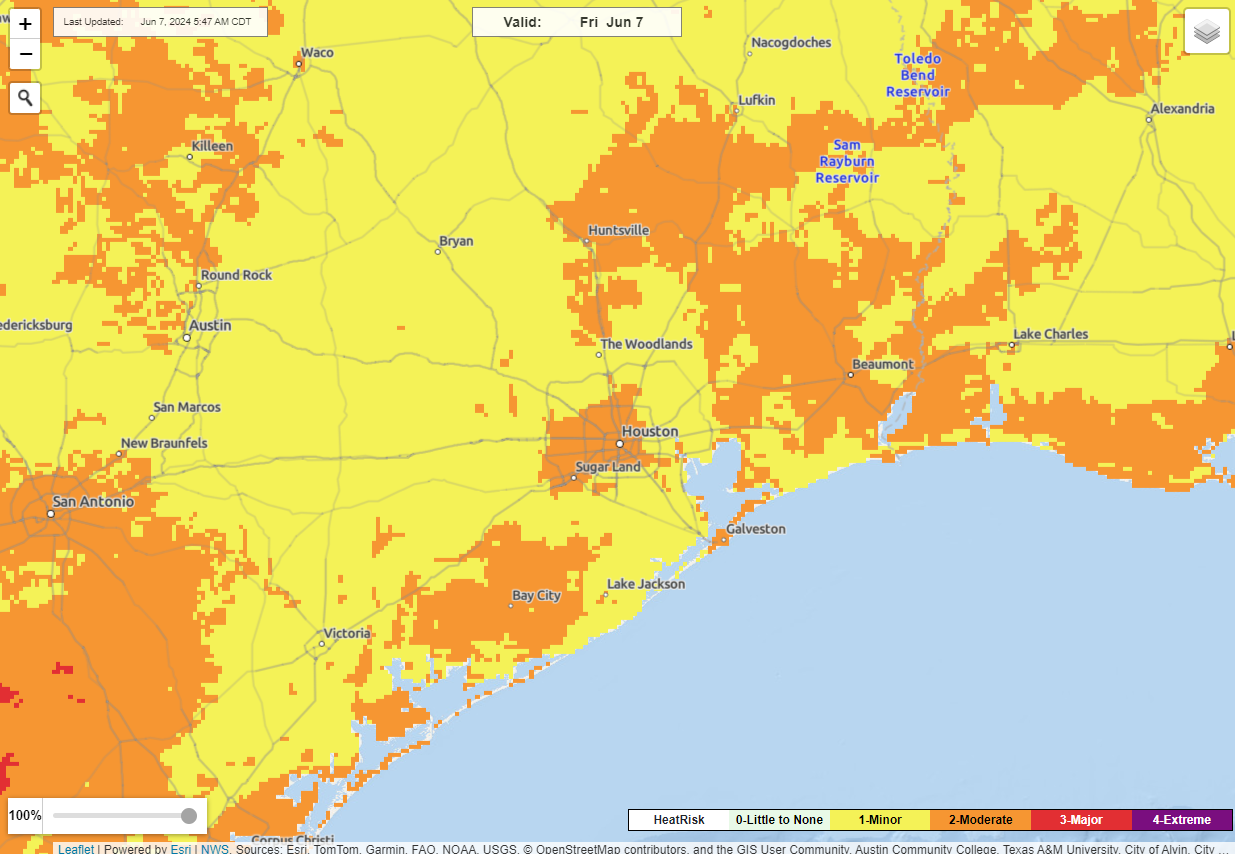
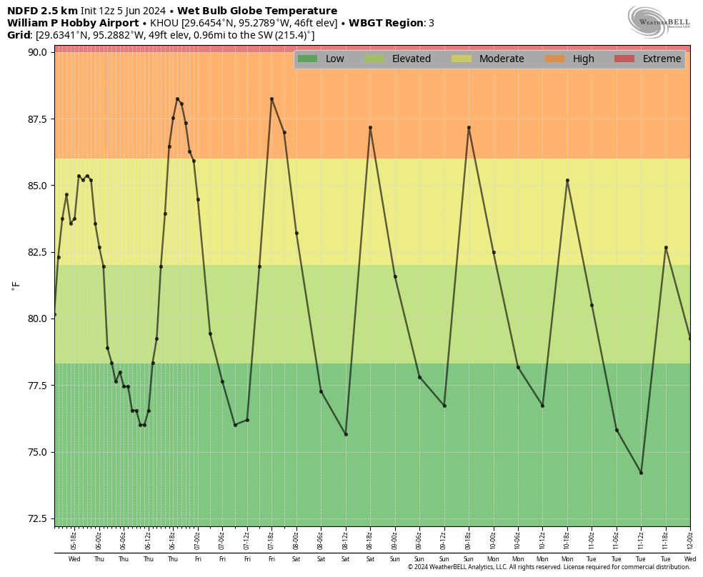
Houston will see fairly normal weather this week for June, which is to say plenty of heat and some humidity, and scattered shower and thunderstorm chances. While that is far from pleasant, I consider this type of weather a win. Why? Because the summer months bring the biggest threats along the upper Texas coast. At this time of year, Houston could be facing significant flooding or a debilitating drought. Temperatures could be in the upper 90s or even triple digits. A hurricane could be forming in the Gulf of Mexico.

In short, boring and not blazing hot during the months of June, July, and August are just fine with me in H-town. However, if this is all too boring for you, be sure and check the outlook for next week at the end of this morning’s update.

Monday

We’ll start the week off with the potential for a few storms. I don’t expect anything crazy, but with fairly high levels of atmospheric moisture and a series of disturbances moving through we’ll see some rain chances through Wednesday. For today that means the development of some showers and thunderstorms during the afternoon and evening hours. I think these will be fairly scattered, so some areas may pick up a half an inch of rain, whereas much of Houston probably won’t see any meaningful accumulations. Skies will be partly to mostly sunny today, with high temperatures in the low 90s. Winds will be light, from the northeast at 5 mph. Rain chances slacken tonight as lows drop into the upper 70s.
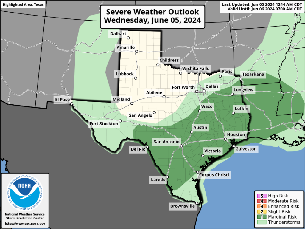
Severe weather outlook for Tuesday and Tuesday night. (NOAA)

Tuesday

This day probably has the best storm potential of the week. It appears as though a complex of storms will develop in central Texas on Tuesday, and push toward Houston during the afternoon and evening hours. It’s not clear how well this line of storms will hold up as it approaches our area, but there’s a decent chance of some storms on Tuesday afternoon and evening for the western half of Houston, and lesser so for the eastern side. Otherwise, expect partly to mostly sunny skies on Tuesday with highs again in the lower 90s for most locations.

Wednesday

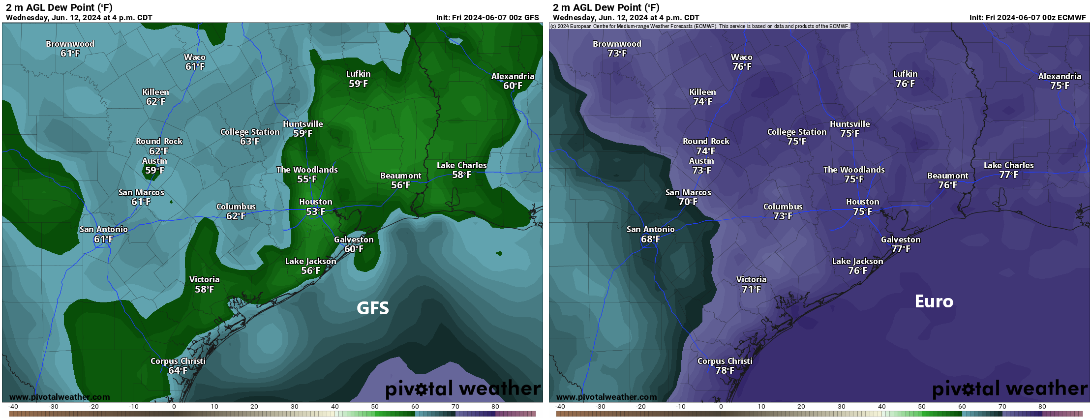
Another day with a slight chance of storms, but otherwise mostly sunny skies and highs in the low-90s. With a continued northwesterly flow we should see the influx of some moderately drier air during the second half of the week, which will push dewpoints down into the 60s. This is not dry air by any means, but the days should feel a little less humid than Houston typically feels during the summer. Mornings and evenings will be a bit nicer as well. This slightly drier pattern should hold through about Friday, or so.

Thursday and Friday

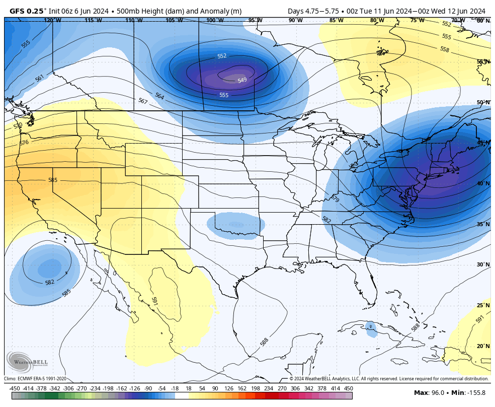
Storm chances should go away for the second half of the work week as high pressure builds over the southern United States. Both Thursday and Friday should see sunny skies with highs in the low- to mid-90s and some of that slightly drier air. Overnight lows will drop into the low- to mid-70s. So again, not at all bad for June.

We’ll see some slightly cooler days in the middle of this week before heat builds back over the region. (Weather Bell)

Saturday and Sunday

The first half of the weekend looks sunny and hot, with high temperatures generally in the mid-90s although a few locations may reach the upper 90s. Sunday looks sunny and hot as well, although there’s the potential for some showers as moisture moves in from the Gulf of Mexico.

Next week

At some point later this week or over the weekend we are likely to see a tropical disturbance develop in the southern Gulf of Mexico. At this time I don’t think there’s much risk for a hurricane to form or anything menacing like that. However, this tropical system could be a heavy rainfall threat for the Texas coast beginning late this weekend and next week as it conveys moisture from the Gulf inland.

We are still at the point in the forecast where there is a ton of uncertainty. For our region, whether we see a little rain next week, or potentially a lot (i.e. 5 or more inches), will depend on the strength of high pressure over the southeastern United States. This will moderate how far north any tropical disturbance can move in the Gulf. (Further north and closer to Houston would increase the potential for heavy rain here). In any case, this is something we’ll be watching over the coming days.

Humidity recharges over Houston this weekend as we wistfully watch the slight chance of another front for Monday

In brief: Humidity will inch back up this weekend as we continue with quiet, hot weather. Another cold front may make an attempt to arrive early next week, but whether it brings a big drop in humidity or just a modest one remains to be seen.

On Thursday, the dewpoint at Bush Airport fell to 64° during the peak of our daytime heating. That’s the lowest it’s been since May 19th. While it was plenty hot yesterday, it was at least a bit less humid than we’ve been dealing with. Any break you can muster in the humidity in summer is a good break here in Houston. And we may have some more of it to come.

Today

We’re expecting a very similar day today as we saw Thursday. A few spots will push the upper-90s this afternoon. Humidity will again be low-ish. Walking outside this morning, it doesn’t feel quite as nice as yesterday, but still not terrible for summer. Heat risk today will be minor to moderate across the area.

Hot, hot, hot today, but it will feel “not totally awful” instead of what we’ve seen much of May and June so far. (NOAA)

One side note: Because of so much sunshine, ozone levels will be high today, and there are air quality alerts for ozone posted. So if you struggle with that, be aware that today will be further unpleasant.

Weekend

The humidity will slowly inch back up this weekend. Look for more of our standard 70s dewpoints with daytime highs in the mid-90s. Rain chances look minimal to near zero on Saturday with ample sunshine expected. Sunday stands a slightly better chance of a brief, passing shower, more in the “it can’t be entirely ruled out” range of things. Morning lows should hold in the mid-70s, with slightly steamier morning conditions.

Monday

The forecast gets very difficult here. From a rainfall perspective, we aren’t expecting anything crazy, just a few showers or storms for now. We’ll keep watch. The tricky part comes with determining how much this cold front can punch through Houston. The GFS model really wants to send the humidity back south to Cancun, while most other model data shows perhaps a modest drop in humidity, maybe similar to what we saw yesterday and today.

Comparison of forecast dewpoints on Wednesday afternoon between the GFS (left), showing a comfortable air mass and the Euro (right) showing a very humid air mass. (Pivotal Weather)

I would lean toward the latter, but there is a world in which the former could indeed come to fruition. History and climatology favors the Euro and other models in this instance. But never say never. Perhaps we’ll come back with good news later this weekend or Monday. One can hope.

Rest of next week

After Monday, the week looks to be somewhere between average and slightly unsettled. We could see a few thunderstorms as a trough settles in over us and we end up placed on the downward side of building ridge to our west and southwest. Temperatures look very benign with generally low-90s and 70s for lows, fairly average for mid-June. We should see temps reach back to the mid-90s by late week or the weekend.

Tropics

Look for a post over at The Eyewall in just a bit that will discuss the potential of a system in the Gulf in about 10 to 14 days. I am not concerned about this from a “big storm” or Houston impacts standpoint. It’s still early in the season and model support is lacking. However, there may be something that tries to get going later next week or after Father’s Day. I’ll have that for you a little later this morning.

Hot days and plenty of sunshine for Houston now through the weekend

In brief: After Wednesday’s showers and thunderstorms, high pressure is more fully in control of our weather and should dominate through the weekend. We’ll have plenty of sunshine, and highs in the mid-90s. By Monday some rain chances return and we’re likely to see some slightly cooler temperatures. But the extent of the rain remains an open question.

Thursday

High pressure has settled into place, and this will set the stage for warmer and sunnier weather for the next four days. This pattern of generally sinking air and a capping inversion should preclude the development of any showers until at least Monday.

A couple of factors will combine to push highs into the mid-90s and, for some inland locations, possibly the upper 90s. These are consistent sunshine during the daytime hours and slightly lower dewpoints. While a dewpoint of 70 degrees is by no means comfortable, it is considerably lower than we’ve seen at points this summer. So mornings and evenings over the next few days will be warm, but ever so slightly less humid. Low temperatures tonight should drop into the mid-70s.

Houston will see high heat levels through the weekend, but with slightly lower dewpoints. (Weather Bell)

Friday

Another hot and sunny day. Additionally, we’ll see light winds, generally at just 5 to 10 mph from the south.

Saturday and Sunday

We’re likely to see continued hot and sunny weather through the weekend, with most locations reaching high temperatures of around 95 degrees. Please do be mindful of the potential for sunburns and skin cancer due to exposure. We are just two weeks from the summer solstice, when the Sun reaches the highest point in the sky. The bottom line is that you can burn quickly during the middle hours of the day.

As high pressure retreats to the southwest next week, rain chances will return to the Houston region. (Weather Bell)

Next week

Some sort of pattern change is is in store for early next week. However, I’m afraid that, at this point, a weak front is unlikely to push all the way into Houston. My best guess for what we see is some increased cloud cover and better rain chances for a few days, perhaps Monday through Wednesday. This, in turn, is likely to help keep daily temperatures in the 90 to 93-degree range, which is fairly typical for this time of year. In any case, I don’t think we’re looking at any crazy kind of storm activity or heavy rainfall potential, probably just light to moderate showers. But as always, we’ll need to fine tune this forecast as we get closer.

Hurricane season

There’s nothing of note yet in the tropics, but we’re starting to see some indications that Atlantic storm activity may start to pick up a little bit in about 10 days. Please join me this afternoon to discuss the season ahead with Reliant’s Lyris Leos. We’ll be taking your questions starting at 2 pm CT on Facebook Live.

Showers and a few thunderstorms are possible today in Houston

In brief: We may see a broken line of showers and thunderstorms move into the Houston region today, although I think rainfall accumulations will be hit or miss. Still, it’s something to be aware of if you’re going to be out and about today. After that we’re looking at several days of hot and sunny weather, although there’s a non-zero chance of a weak front early next week.

Hurricane season outlook

As you probably know, a majority of predictions have forecast the 2024 hurricane season to be especially active. On Thursday I’ll be discussing the seasonal outlook with Reliant’s Lyris Leos, and what Houstonians should consider heading into the season. The broadcast will occur at 2 pm CT on Facebook Live, and will also be available as a recording afterward. You can ask questions in the comments below, or on Facebook.

There is a marginal risk for severe weather in the Houston region today. (NOAA)

Wednesday

There is a complex of thunderstorms near Waco and Lufkin this morning that will move steadily southward. Although I’m not convinced this line of organized storms will hold together, some showers and thunderstorms may move into Houston later this morning, likely reaching areas such as The Woodlands and Kingwood 10 am to noon, central Houston an hour or two later, and pushing into coastal counties around noon or shortly after. Anything that develops will likely have cleared the area by this evening’s commute.

Rainfall amounts will be widely variable, with a few isolated locations perhaps seeing 1 to 2 inches of rain, and many other parts of the metro area no accumulations at all. I can’t rule out some severe thunderstorms with this line, but overall the chances for strong winds and hail are fairly low. Highs will depend on the extent of clearing this afternoon, but most locations should reach the low 90s with partly sunny skies after the system passes through.

Thursday

A sunny and hot day, with highs in the mid-90s across much of Houston. Rain chances look to be close to zero. Winds will be light, from the south.

Friday

Another hot and sunny day, likely the warmest of the week. Expect parts of Houston to reach the upper-90s.

Houston will see “high” heat this weekend. (Weather Bell)

Saturday and Sunday

The weekend should see continued hot and sunny weather, with highs in the mid-90s and plenty of humidity. Rain chances are low to non-existent. Lows will be in the upper 70s.

Next week

The forecast turns more interesting early next week. I’m not ready to make any guarantees, but there is an increasing likelihood that some sort of weak front may work its way into Houston. Since we’ll be well into June at that point, we still should be somewhat skeptical, but there’s a decent chance we’ll see some showers on Monday or early Tuesday, followed by an influx of some somewhat drier air. We should have more confidence in this forecast by tomorrow or Friday.