A tropical storm is likely to develop near Texas soon. Here’s what that means for Houston

In brief: A tropical storm is likely to form just off the Texas coast within a couple of days, and it could bring some rains and winds to Houston on Tuesday and Wednesday. How impactful the storm is will depend on how close to the Texas coast it gets. For now, we are leaning toward far enough offshore to avoid significant disruptions in Houston. But the forecast is not locked in.

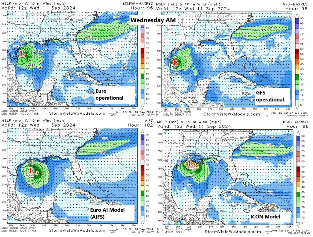
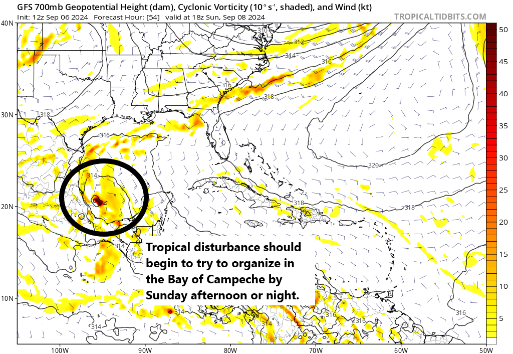
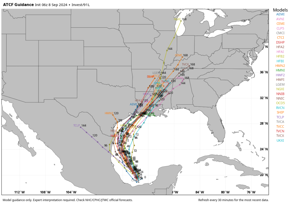
All of our available data continues to point toward the formation of a tropical storm in the western Gulf of Mexico within the next 48 hours or so. Our confidence is pretty high that by around the Tuesday afternoon to Tuesday night period this system will be positioned 50 to 150 miles offshore the Texas coast, about due east of the mouth of the Rio Grand River.

At sunrise this morning in the Gulf, we’re seeing more organized storms in the Bay of Campeche. (NOAA)

The question for Houston is, what happens after that?

Over the last several runs, we’ve seen better model agreement in those outcomes. So while I’m not ready to say this is a high-confidence forecast, I do feel as though it is fairly likely to occur. By Wednesday the storm will probably be moving more or less parallel to the Texas coast, to the north-northeast. Then by Wednesday evening or Thursday, the system—most likely a tropical storm, but it’s impossible to rule out strengthening into a hurricane—would make landfall somewhere in southwestern Louisiana.

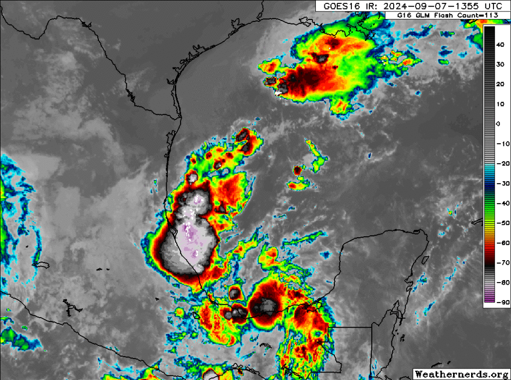
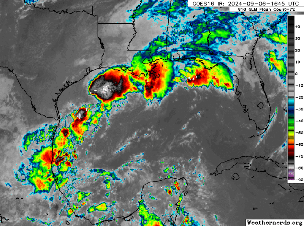
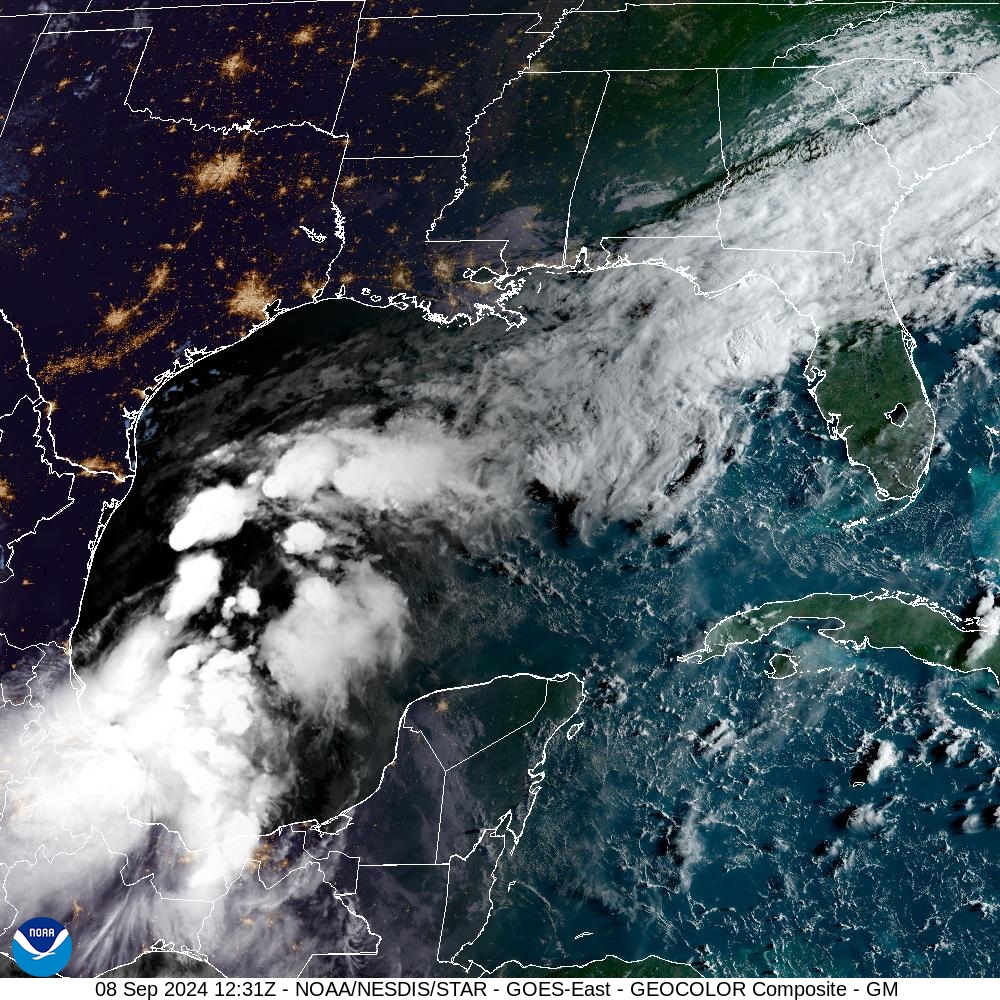
This forecast can change, and indeed anyone who has followed tropical weather knows to expect the unexpected. Additionally, this area of low pressure that we’re talking about remains a fairy disorganized mass of showers and thunderstorms in the southern Gulf of Mexico as of Sunday morning. The accuracy of the models should increase as a center of circulation forms today and Monday. However, at this time all of our guidance is pointing to a scenario in which this tropical system gets fairly close to the Texas coast, but then remains offshore as it moves to the northeast.

Virtually all of our model guidance, including several not shown on this plot, keep the tropical system off the Texas coast. (Weather Bell)

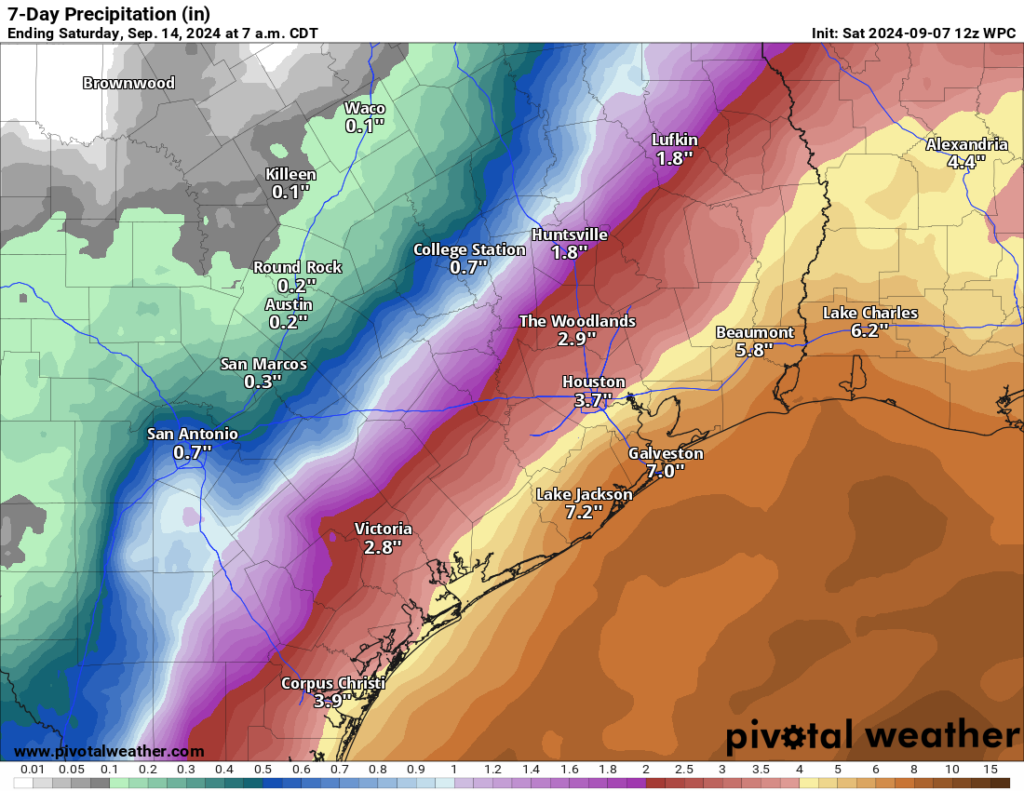
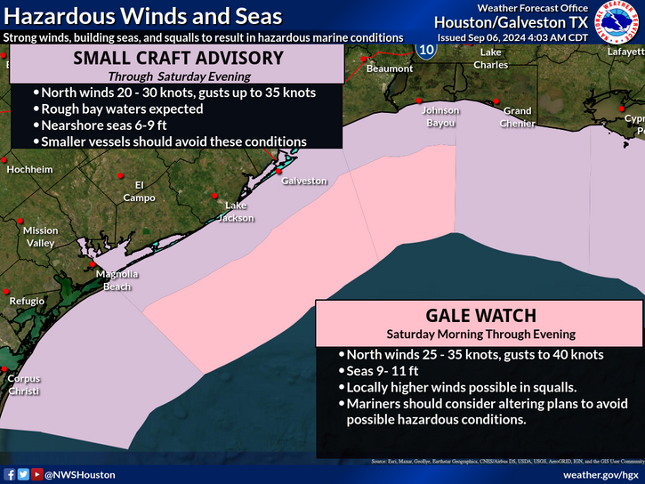
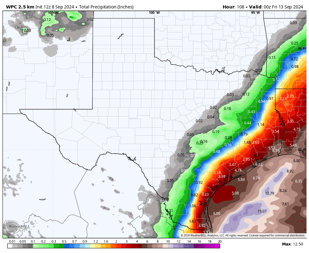
Ok, with those caveats aside, what happens in Houston under such a scenario? Basically the same areas that saw a lot of rain last week are going to see more rainfall. That is, coastal counties will be most at risk for heavy rainfall, with the possibility of picking up an additional 3 to 6 inches. This forecast remains highly dependent on how close the tropical system passes to Houston, of course. A storm closer to shore would nudge the heavy rainfall into all of the Houston metro area, and a storm a bit further offshore keeps the heavy rain away from even places such as Galveston Island.

As for winds and seas, with the storm offshore, the worst of these effects would be to the east of the center. Therefore, while winds and seas should increase along the upper Texas coast, with the current forecast they would not be anything extraordinary. We’re talking something like wind gusts of maybe 30 to 35 mph right along the coast, with lesser winds inland; and tides 2 to 3 feet higher than normal. Remember, both of these effects are very much tied to the track of the storm, so precise forecasts are impossible at this time.

The most impactful rains would stay offshore in such a scenario. (Weather Bell)

In terms of timing, the most impactful days for Houston’s weather will probably be Tuesday and especially Wednesday.

The bottom line is that, right now, we don’t anticipate major impacts in the Houston area from this tropical system. That could, of course, change. If it does we’ll let you know as soon as our thinking changes. Expect another post later today, from Matt, on the latest forecast and a broader look at impacts for the Texas and Louisiana coasts.

A tropical system is likely to develop in the Gulf of Mexico early next week—here’s what to look out for

In brief: Development of some sort of tropical system is becoming increasingly likely in the western Gulf of Mexico next week. Generally, there are two potential outcomes: Either a better organized system that tracks offshore toward Louisiana, or a lesser organized system that tracks offshore but closer to the Texas coast. In this post, also published on The Eyewall, we go deeper on what could happen and its implications for the greater Houston region.

The state of play as of early afternoon on Saturday is that we have a fading system in the northern Gulf of Mexico, which was responsible for much of our rainfall this past week; and we also have Invest 91L with thunderstorm activity in the southern Gulf, but no real organization. Our focus should now turn toward 91L, in the southern Gulf.

Invest 91L is somewhere in the southwest Gulf without a whole lot of organization. (Weathernerds.org)

At some point heading into later tomorrow, Invest 91L will probably halt its southward progress, slow down and begin to make a turn back northward later on Monday. From here, we’re beginning to see some model consensus increasing around this becoming at least a tropical storm by Tuesday or Wednesday. Development odds from the National Hurricane Center have increased to 70 percent as of this afternoon.

As 91L comes north, it will enter a tricky environment from a forecast point of view. On the one hand, you will likely have low shear and warm Gulf waters to help it along. On the other hand, there is likely to be a lot of dry air over Texas thanks to this weekend’s early fall cold front. That dry air works against tropical development. We’ve seen dry air in Texas take its toll on tropical systems before, so that’s one reason to be cautious about some of the more bullish models.

Dry air is likely to work somewhat against development and organization. It will almost certainly limit how far inland the heaviest rain can make it next week. (Tropical Tidbits)

Whatever the case, slow, gradual development is likely late Monday and Tuesday as this comes north about 100 to 200 miles off the coast of Mexico. Modeling is actually in very good agreement on all this through Tuesday morning. From that point, the models diverge. The European model, which I might argue would have a better handle on more of the nuance at play here, tends to develop this slowly. The GFS, ICON, and Euro AI (AIFS) modeling shows a slightly faster development path for 91L on Tuesday into Wednesday.

This poses an interesting forecast challenge. The upper pattern on Tuesday night/Wednesday morning will support steering currents around the periphery of high pressure off the west coast of Florida. This should allow for a north and northeast track in the Gulf. A stronger storm would probably be more apt to take that northeastward movement, where as a weaker storm may come more due north. We see this as both the ICON and AIFS show a faster, stronger storm farther out in the Gulf headed toward Louisiana, whereas the European model keeps it weaker and close to the mouth of the Rio Grande River.

Four operational model forecasts on Wednesday morning, with the AIFS & ICON showing a stronger tropical storm or even hurricane risk near Louisiana, whereas the Euro and GFS are weaker and slower (farther south) with more rain in Texas. (StormVista)

The GFS eventually caves and strengthens it, allowing the system to follow the AIFS/ICON group toward Louisiana, whereas the European model just brings it into Texas as a depression or low-end tropical storm.

Obviously, this gives us a forecast challenge, but I think we’re in two very distinct camps right now.

  • Camp 1: A strong tropical storm or hurricane that tracks off the Texas coast toward Louisiana arriving Wednesday-ish.
  • Camp 2: A depression or loosely organized tropical storm with a lot of rain that impacts Texas, especially at the coast Tuesday through Thursday, coming ashore between Galveston and Cameron, LA.

I am not a betting man, but I would probably say the odds right now are 70/30 in favor of camp 2, but that 30 percent is a weighty one given that the system could be a hurricane in that scenario. Normally, I’d discount the ICON model, but given its performance this season and the consistency it has had with track and intensity here, I think there’s merit to considering it with this particular system.

Regardless of development, heavy rainfall is likely on the coast of Texas and into much of Louisiana. The inland extent of rain in Texas will be limited, and the gradient, or difference between high and low amounts of rain could be much sharper than shown in today’s NOAA rainfall forecast. (Pivotal Weather)

So what do you do? You check back in again tomorrow for more. If you’re in Louisiana, it’s probably a good idea to make sure you have your hurricane kits up to date and know what you’ll do in the lesser chance this comes your way as a stronger storm. In Texas, I think Houston and Corpus Christi are fine. However, I think folks from Matagorda Bay through Sabine Pass along the coast and bays should probably be aware of both a rainfall flooding risk and a tidal flooding risk that may develop from this. More to come.

Note

We’ll continue to monitor this storm closely. If the forecast materially changes, and we are likely to see more directly threats in terms of wind and surge in the Houston area, Space City Weather will publish an update early on Sunday morning. If the forecast remains more or less the same, look for an update later in the day.

The Gulf of Mexico is heating up with tropical activity, but for now we’re mostly concerned about rainfall next week

In brief: We are continuing to track a couple of tropical threats to the Gulf of Mexico. To put this into perspective, we’re sharing content published earlier today on The Eyewall. Though a serious system is not likely to develop, locally heavy rain and flash flooding are a good bet along the coasts of Texas and Louisiana during the middle of next week.

As of this afternoon the northern Gulf of Mexico looks fairly spicy when it comes to tropical activity, and the system in the northern Gulf of Mexico has now been dubbed Invest 90L. It’s drifting southward, while a lot of its moisture gets sheared off to the east. Basically, it’s beginning the transition into its next phase of life now.

Invest 90L is a little tough to pinpoint, but it’s technically drifting south, while a lot of the moisture and rain associated with it lifts off to the east and northeast. (Weathernerds.org)

From here, 90L should drift all the way south into the Bay of Campeche where it’s going to finally meet up with the tropical wave we’ve been discussing ad nauseum that’s exiting the Caribbean today. Whether this gets classified as Invest 91L or stays 90L, I don’t know. It’s a procedural mystery. Whatever the case, I’m going to refer to it as 90L.

Anyway, by the time we get to Sunday, this whole mass congeals in the Bay of Campeche. It probably won’t develop right away, but it will begin to stir a bit.

By Sunday, the GFS model above shows Invest 90L or whatever it is organizing in the Bay of Campeche, not far off the coast of Mexico. (Tropical Tidbits)

In general, from here we expect this thing to track northward. I think we stop at this point in terms of talking about specifics. Everything becomes kind of theoretical. If 90L forms farther offshore, it may have a better chance to organize a bit more and track more due north or north-northeast toward extreme east Texas. The stronger it gets, the farther northeast it will go, deeper into Louisiana. If 90L continues to hug the coast of Mexico, as shown on the GFS here, it would likely try to become a tropical storm and then slide inland. A weak system would probably come ashore *in* Mexico, whereas a slightly more organized depression or tropical storm would track more toward the Texas coast.

The ceiling on this is *probably* below hurricane intensity right now, if it develops. Never say never obviously, but virtually all the signals we are getting from tropical models, operational models, and ensemble guidance keeps this as a tropical storm or weaker. So from a “will we see widespread power outages and/or major hurricane damage” perspective, the answer is almost certainly not at this point.

But, I would advise folks between northern Mexico and Vermilion Bay in Louisiana to keep monitoring this through the weekend.

Gulf Coast rainfall concerns

Now, the bigger concern I have with this system is rain. Rainfall over the last 10 days or so has been prolific in portions of Texas and Louisiana.

The percent of normal precipitation over the last 2 weeks has been over 200 percent of normal across much of coastal Texas and portions of Louisiana, as well as interior Texas. (High Plains Regional Climate Center)

The Houston area has been primarily spared significant rain, but Galveston has seen over 10 inches. Louisiana has seen significant totals also. As has Corpus Christi. So there are a lot of vulnerable areas in between some areas that could handle rain fine next week. I won’t post a rainfall forecast because that outcome will depend on if a storm develops and how it tracks. There will be locally heavy rain even without a formal named storm, so no matter what, we’re looking at the potential for another 4 to 8 inches of rain or more in spots next week as this comes northward Tuesday through Thursday.

Bottom line: Check in on this again this weekend.

Cold front weekend is here in Houston! Then, more rain chances next week

In brief: Our first real legitimate autumn cold front will arrive on Saturday, and it should usher in an utterly spectacular fall day on Sunday. This will be followed by a return to a stubborn offshore low pressure system and front to drive up cloud cover and rain chances for next week. We continue to babysit it for tropical development but do not expect it to organize at this time.

The last time Houston had an official low in the 60s, the Astros were 25-33, behind both the Rangers and Mariners in the AL West standings. Despite a rough few days in Cincinnati, the Astros are 10 games above .500 and sitting 4 and a half games up on the Mariners. Our friends in Arlington are 8 games out of the last wild card spot. It’s been awhile. And this weekend, we should get to experience both a much better positioned baseball team than May 31st, as well as the coolest weather since then.

Today

It’s been a wet stretch. Galveston has had nearly 10 inches of rain since late August. Bolivar has seen 15 inches. We’re going to see the rain begin to slow down now, and we will drop the Stage 1 flood alert for the coast today. We may still see some showers today, especially at the coast again but it should be manageable in most cases. Other than that, expect clouds and sun with highs reaching into the middle or upper-80s.

Rainfall over the next couple days should be no more than what is shown on the map above, and many place may even come up a little short of these forecasts. (Pivotal Weather)

Saturday

As the offshore low pressure system that’s flung rain our way begins to migrate eastward tomorrow, the much advertised cold front we’re expecting is en route. This drier push of air will help shut down the moisture feed inland, reducing shower chances to merely a passing chance at the coast tomorrow. There will be a bump in wind tomorrow at the coast, however, and there are small craft advisories and gale watches posted.

Last weekend saw rain, and this weekend will see wind be the issue on the Gulf Coast. (NWS Houston)

The cold front itself will probably push into Houston sometime around early afternoon. I doubt you’ll notice much as it passes. Humidity will gradually drop off later in the afternoon and evening, and that’s when you should really notice a change. The Dynamo game will be great. Temps will peak in the mid-80s after morning lows in the 70s. We may get back into the low 70s and have a midnight minimum temperature on Saturday night.

Morning lows on Sunday will be as crisp as they’ve been since May, with even an outside chance of 50s in rural locations north of The Woodlands and Conroe! (NOAA)

Sunday

Sunday morning should dawn sunny and delightfully pleasant. Lows in the 60s with low humidity, dewpoints in the 50s, and a slight breeze. Even Sunday afternoon will be nice, with highs in the low-80s. If you’re in Indy for the Texans opener, it’ll be in the 40s for morning lows, so any early tailgating may need a jacket up there! Really, just a delightful day. Maybe we can even get the roof open at Minute Maid Sunday night?

Coastal locations will have the trickiest forecast on Sunday. The front should clear the coast, and there should be that push of dry air all the way past Galveston and down to Matagorda Bay. However, there’s always an off-chance that something is being missed in the model guidance and we end up cloudier or a little more humid than expected down that way. Just something to note.

Next week

If you’ve been reading Eric’s posts here this week or my posts at The Eyewall, you know we are still monitoring the potential for tropical development in the Gulf next week. We don’t think anything will formally organize from this, but the Gulf, September, etc. You just have to babysit it.

Regardless of that, it is likely that some type of low pressure and/or stalled front sits off the Texas coast next week, similar to what we’ve been dealing with this week. In that scenario, we will likely see rain chances return as early as Monday and particularly on Tuesday, Wednesday, or Thursday. We could again see locally heavy rain, especially at the coast. And this is without tropical development. If we were to see tropical development, that may actually help keep more rain offshore, as the system would probably track just east of our area. So while our base case forecast will call for no tropical development, it does at least merit mentioning and babysitting on our end. We will keep you posted through the weekend and have more tomorrow or Sunday if necessary. That being said, the rain totals over the next week continue to look rather impressive, so we’ll have to keep an eye on how that unfolds going forward, particularly for saturated coastal locations.

Tropics

Beyond the potential development from the Gulf low next week, there is very little for us to discuss in the tropics as it relates to Houston or anywhere for that matter. The next wave to emerge off Africa heading into next week seems to have a decent chance of developing but also seems as if it will turn northwest rather quickly and stay out at sea. Given the expectations for this season, this is as good as you could ask for on September 6th. Fingers crossed it continues.