In brief: Today’s post looks back at October, and explains why the weather has felt so incredibly hot in Houston this month. We also look ahead to the return of rain chances this week after a very long dry spell. And finally, we preview the arrival of substantially cooler weather during the latter half of next week.
Putting October’s record heat into context
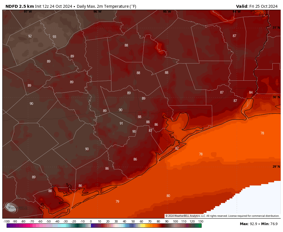
You may have noticed that this October has felt hotter than normal, and you’re not wrong. A majority of days so far, 18, have reached a high temperature of 90 degrees or above. We have set daily highs on five days so far this month, including two extremely warm days (99 and 98 degrees) in the middle of the month before a front rolled through.
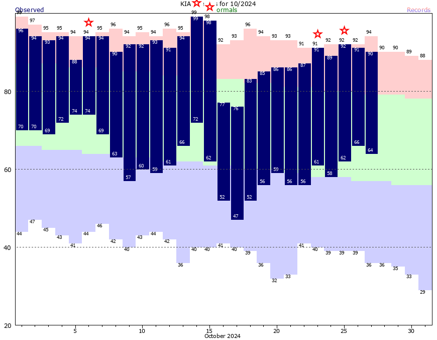
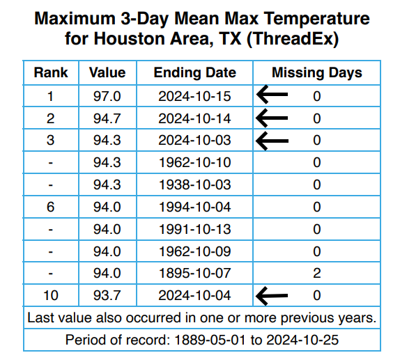
One way to assess the impact of heat is to look at three-day stretches. That is, if we take a three-day period in October, how does it rank among hottest three-day periods in October history? Well, in this case, four of the ten hottest three-day periods in October occurred during this month. The three days in the middle of the month produced absolutely unprecedented heat for this time of year.
So what caused this heat? One cannot escape the background signal of climate change when we’re setting daily high temperatures like this. But if we dig a little deeper there is more at play here. Let’s start with daily high temperatures: the average so far this month is 90.2 degrees, which is on pace to smash the previous record of 86.5 degrees set in 2016. So our days, at least during the 135 years of records we can refer to, have never been hotter. However, our average low temperature this month has been 62.5 degrees. This ranks 42nd all time. That is very far from abnormal. (Note these numbers are not final, but will not change too much before the end of the month.)
What we can derive from this data is that Houston, generally, has had a drier flow this month with a lot of easterly breezes. This has kept dewpoints down bit. Therefore we have had hot and sunny days, with cooler clear nights. Based on average temperature, this month will still end up among the five warmest Octobers of all time—the daytime highs have been that extreme—but comparatively speaking our nights have been relatively mild.
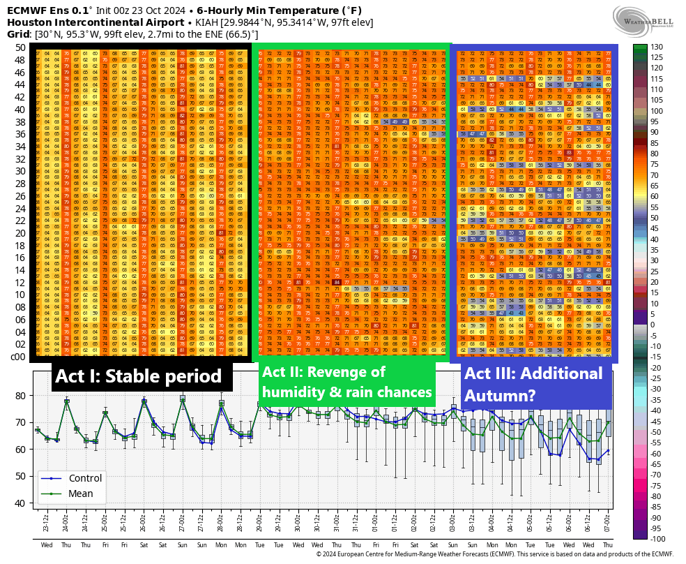
Monday
I write all of that to say the humidity is coming back this week, and you’re going to notice the southerly flow. Winds today will be from the southeast, with gusts up to 20 mph. We’ll see mostly sunny skies, with highs in the upper 80s. Low temperatures tonight will only fall into the lower 70s, so it will be very muggy outside.
Tuesday
Conditions will be similar to Monday, in terms of warmth and mostly sunny skies. The only difference is that our southeasterly winds will increase, and we may see some gusts up to 30 mph during the afternoon hours. So it’s really going to be blowing and going. Lows on Tuesday night may only fall into the mid-70s.
Wednesday
Expect partly to mostly sunny skies on Wednesday, with highs in the mid- to upper-80s. Some scattered rain chances return, especially for the coast, during the afternoon hours. Overall accumulations look fairly slight. Lows on Wednesday night will drop into the low 70s.
Halloween
It has not rained in 70 bajillion years in Houston, and of course the first day with really health rain chances comes on an outdoor holiday. Look, I’m not complaining about the rain, since we desperately need it. But on Halloween? Anyway, the good news is that while most of the region should see some light showers on Thursday, they’re likely to fading by around sunset, when trick-or-treating begins. The daytime showers will be driven by a very weak front that should help knock high temperatures into the lower 80s. Nighttime lows remain very warm.
Friday, Saturday, and Sunday
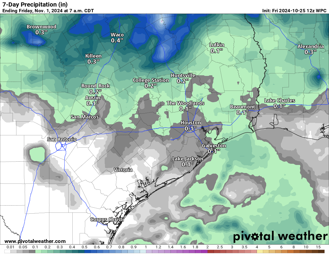
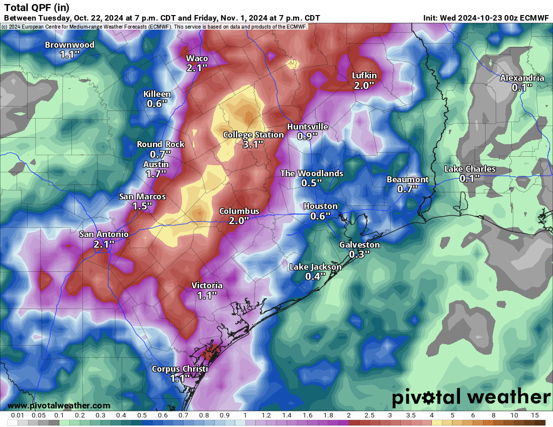
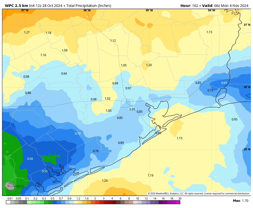
Highs over this period will range from about 80 to 85 degrees for the metro area, with a mix of sunshine and clouds. Each say will see a modest chance of rain, perhaps on the order of 30 to 40 percent. Nights remain warm and muggy. It’s worth noting that although the region will see some welcome rain chances this week, overall accumulations will likely be 1 inch or less for most locations. That is nice, but unlikely to bust our drought.
Next week
The first part of next week should see continued warm and muggy weather, with some modest rain chances. However, there is a very strong signal that by Wednesday or Thursday we’re going to see a fairly robust cold front that should knock our temperatures back to seasonal levels, with lows in the 50s or so. This is far enough out to retain a bit of skepticism, but it does seem pretty clear that we are going to see a significant pattern change some time next week.