Some relief in temperatures is on the way, but no rainfall is in sight for Houston

In brief: The greater Houston region faces one more very warm day before drier and moderately cooler air arrives tonight and on Tuesday. And then, the forecast remains one of persistence with sunny, warm days, cooler nights, and for Houston, pleasantly dry air for as far as the eye can see.

No rain

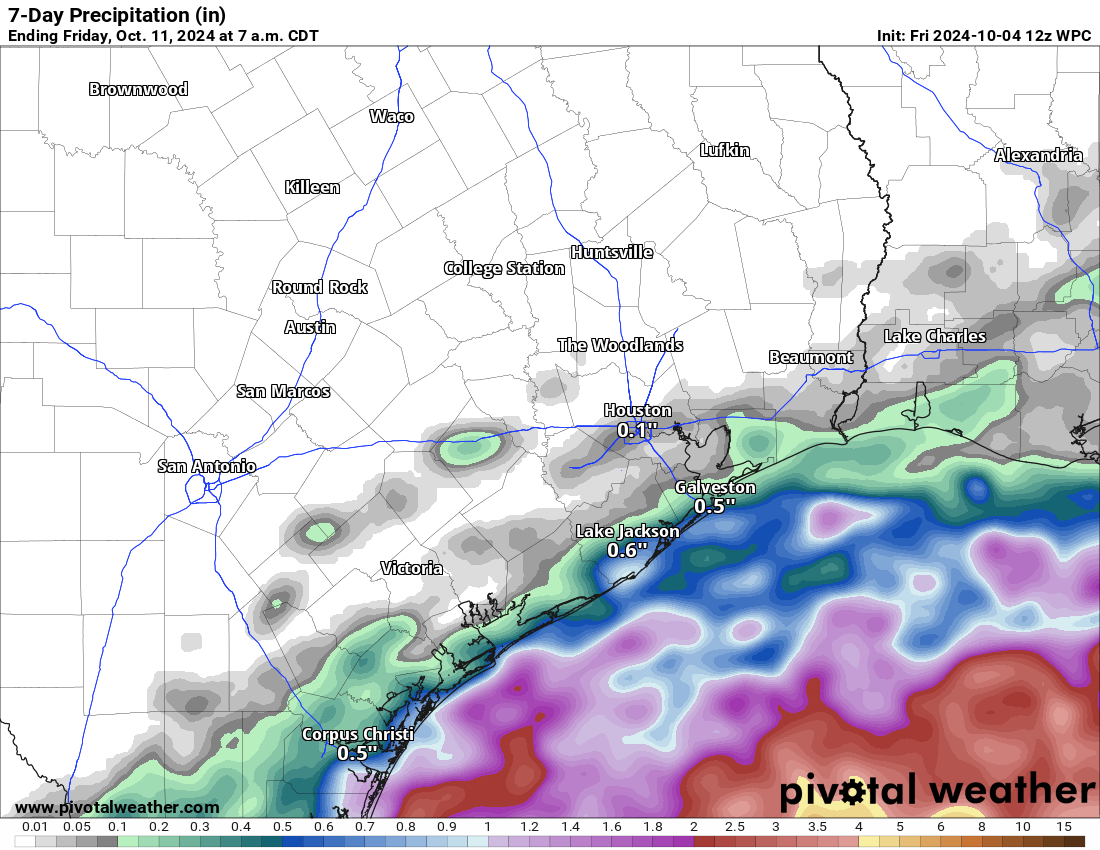
Our average high temperature so far this month has run above 93 degrees, which may be normal for late August, but is decidedly not for early October. This late summer pattern definitely needs to break. Fortunately, we’ll see some cooler and drier air to help with that in the coming days, but what we’re not going to see much of is rainfall.

As expected, showers this past weekend remained mostly offshore. Our next chance of rain, meager though it may be, does not come for another 10 days or so. Even clouds will be scarce this week, and into the weekend, as somewhat drier air prevails for awhile. In other words, expect sunny days and mostly clear nights for the foreseeable future.

Drought conditions are creeping closer to the Houston metro area with continued dry weather. (US Drought Monitor)

Monday

We’re going to see one more day of temperatures in the low 90s across the metro area today, ahead of the arrival of a front that pushes in from the northeast. This will be what is sometimes called a “backdoor” front as the main thrust of the colder and drier air goes to our east, but a finger or whirl of cooler and drier air is spun out, and southward into Houston. Already, dewpoints will be in the 60s today, so while the air will feel warm, it also won’t feel Houston humid. Winds today will be fairly light, from the northeast. Low temperatures tonight will drop down to around 70 degrees.

Tuesday

Even drier air will arrive on Tuesday morning, pushing dewpoints down further. As you probably now, drier air heats up more efficiently than humid air, so because this is not a strong push of colder air from the north we’ll still see warm days this week. Especially with the sunshine. As a result, Tuesday will see highs in the upper 80s, with overnight lows dropping into the lower 60s for much of the city away from the coast. Areas further inland will see the upper 50s on Wednesday morning.

By Wednesday morning lows will drop into the 50s for outlying areas. (Weather Bell)

Wednesday through Friday

More of the same. We’ll see sunny and warm days, in the upper 80s. Nights will be pleasant, in the low- to mid-60s in Houston, with cooler conditions outside of the city. With lower dewpoints the air won’t feel particularly humid. For early October, this is pretty nice weather.

Saturday and Sunday

The outlook for the weekend really doesn’t change much: sunny skies with highs in the upper 80s to possibly 90 degrees, with cool-ish nights in the mid-60s. If you have outdoor plans for this coming weekend, proceed with confidence in the weather.

Next week

Sunny skies with highs around 90 degrees will probably continue into the middle of next week, when perhaps a bit stronger front arrives. The details on this one are fuzzy, naturally, but it has the potential to drive nighttime temperatures in the 50s and, if we’re lucky, bring some rain chances with it. We shall see.

Hurricane Milton will strike Florida on Wednesday or Wednesday night. (National Hurricane Center)

Tropics

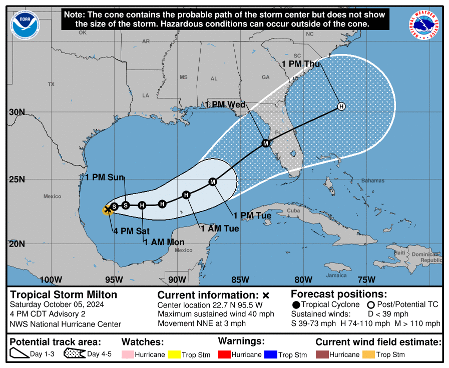
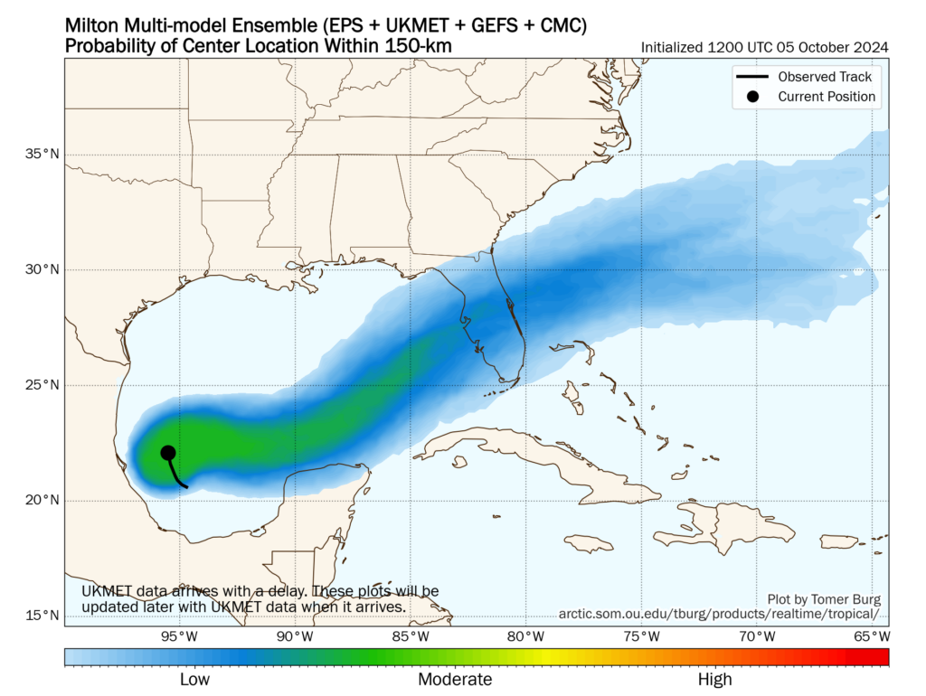
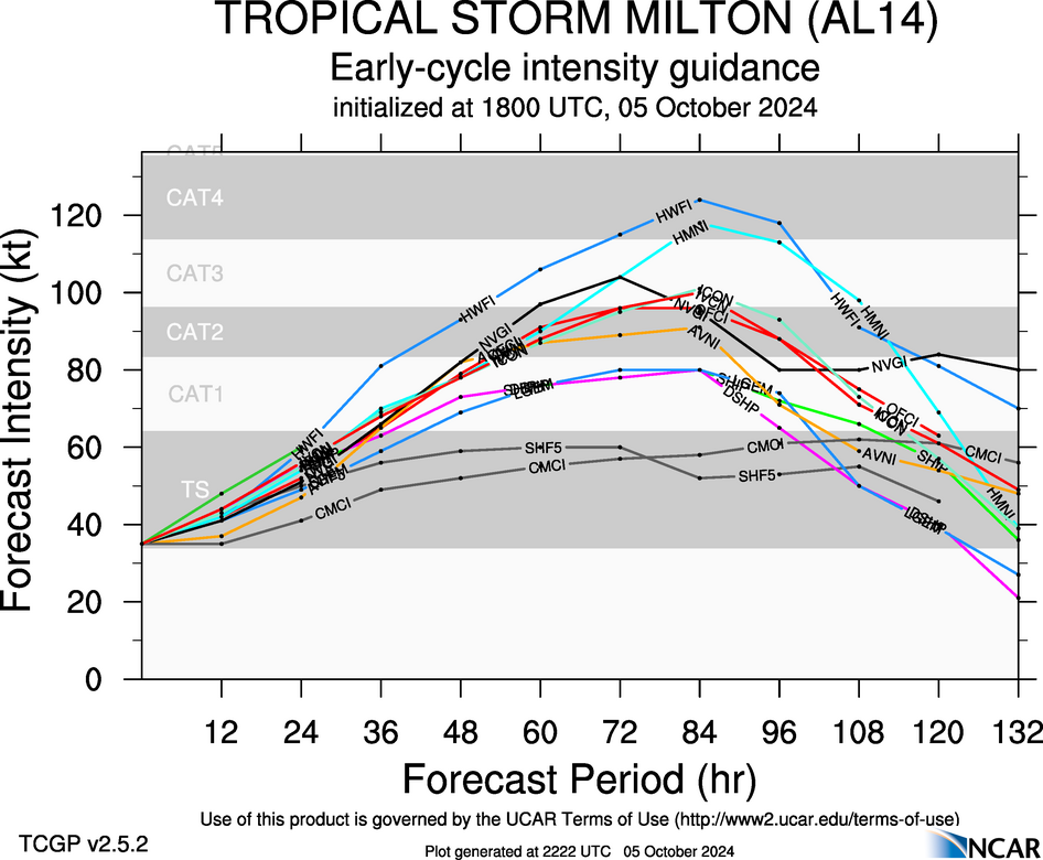
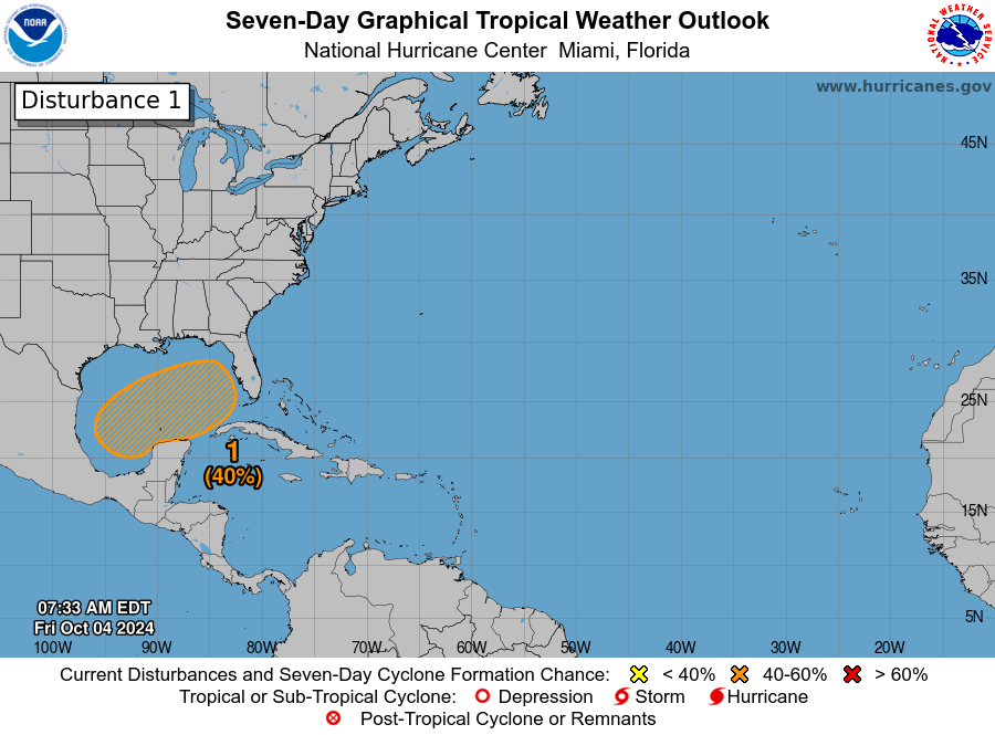
There remain zero concerns to Texas. We are now firmly in the offseason for hurricane activity. However Milton became a major hurricane this morning in the southern Gulf of Mexico, and it poses a very significant threat to Florida on Wednesday and Thursday of this week. The Tampa Bay region of the state has not been directly hit by a major hurricane in more than a century, but that could well change this week. We have continuing coverage on The Eyewall.

Tropical Storm Milton forms in the Gulf: Zero impacts for Texas, but a very serious threat to Florida

In brief: Tropical Storm Milton formed in the Gulf of Mexico this afternoon. Normally, a tropical system in this part of the Gulf would be of serious concern to Texas, but since we’re now in October, the overall steering pattern generally pushes tropical systems away from our state. We’re sharing this post from The Eyewall because we’ve had several questions about Milton, and know many readers have family and friends in Florida.

At 5 pm ET on Saturday, the National Hurricane Center upgraded a tropical depression in the extreme southwestern Gulf of Mexico into Tropical Storm Milton. The center of the storm is nearly stationary this evening, but it should start to move slowly to the east over the next day or so before accelerating. Although it is unusual for a tropical system this far west in the Gulf of Mexico to move toward Florida, that’s exactly what we expect to happen over the next four days in response to blocking in the mid- and upper-levels of the atmosphere.

4 pm CT track for Tropical Storm Milton. (National Hurricane Center)

Although we remain about four days—give or take—from a landfall along the west coast of Florida, it is important for residents of the state to take Milton very seriously. We realize that some areas of the state remain dazed by Hurricane Helene, but this is a similarly threatening storm. Although we don’t have full confidence in precisely where the storm will track, it does seem very possible that it will directly impact the greater Tampa-St. Petersburg-Clearwater metro area, which has a population in excess of 3 million people.

Please remember that the forecast can and will change in the coming days. However, we have seen a fair amount of tightening in the model solutions over the last 24 hours, and increasingly they are pointing to a powerful hurricane approaching the western Florida coast, possibly near or north of Tampa Bay, by around Wednesday of next week. This post will discuss our preliminary assessment of some of the impacts from this storm.

Track and intensity

There remains a broad cone of uncertainty in regard to where Milton will go, but we can expect this to narrow somewhat during the next day or so. After Milton wobbles around the southwestern Gulf of Mexico for the next day or so, it will get picked up by a front moving down into the northern Gulf of Mexico. This will help steer the storm the east, and then the northeast over the next few days.

A view of the ensemble uncertainty in regard to Milton’s track this week. (Tomer Burg)

Most of our best modeling guidance, including hurricane specific models such as the HWRF and HAFS, brings the storm to the western coast of Florida, near the Tampa Bay region, very late on Tuesday night or Wednesday. Now that a fairly well defined center of circulation has formed, I expect modeling agreement to increase over the next day or so.

In terms of intensity, there is a broad range of outcomes. The National Hurricane Center predicts a major, Category 3 hurricane at landfall on Wednesday. However, an even more powerful storm is possible given that the Gulf of Mexico is very warm, with deep oceanic heat content, and wind shear levels unlikely to disrupt Milton’s organization. Unfortunately, this is a setup for the development of a large and powerful hurricane.

A sampling of Milton intensity forecasts from global and hurricane models. (NCAR)

Winds

Milton’s track will determine where the storms strongest winds occur; they will be along the path of the center and generally just to its right. The majority of our guidance continues to point to a hurricane somewhere between Category 2 and Category 4 intensity, which means that there is the potential for a large stretch of the Florida peninsula to experience hurricane-force winds. This level of winds will cause significant damage and likely lead to power outages.

Storm surge

With four days to develop, Milton is ultimately going to push a large and powerful storm surge toward Florida. This storm will almost certainly impact areas south of where Hurricane Helene struck in September, but at this point anywhere from the coastal bend of Florida, south to the Tampa Bay area, and further south to Fort Myers, is at risk. It is too early to talk about absolute risks, but for wherever Milton makes landfall, the storm is likely to bring a historically damaging storm surge. These impacts will be most pronounced just to the right of where the hurricane makes landfall—which again, is a location that we cannot say with any certainty yet.

Inland rainfall

Heavy rainfall is another threat from Milton. Although the storm should be moving at a fairly good clip once it reaches Florida by the middle of this week, Milton could nonetheless drench a swath of the state, from west to east as it crosses the state. Whether this occurs in the central part of the state, such as the vicinity of Orlando and the Space Coast, or further north in the coastal bend and Jacksonville, is just not clear yet. However, the risk is there for 10 or more inches of rainfall in a short period of time, which will lead to flash flooding.

Most likely arrival time of tropical storm force winds. (National Hurricane Center)

Conclusions

If you’ve read this post up until now, you’ll realize that we cannot say much more at this time beyond stating that a serious hurricane threat is coming to the state of Florida this week. Sunday and Monday will be a time for preparations, as impacts such as wind and heavy rain are likely to reach the state as early as Tuesday evening.

We will have continuing coverage on The Eyewall as this very serious threat develops.

Some rain chances this weekend, but mostly near the coast as Houston moves on with hot days and cooler nights

In brief: Houston will continue a string of hot days, but the nighttimes should become a bit more pleasant as well. A cool front on Monday will take care of that for us. Rain chances this weekend are mainly at the coast and mainly just scattered, and no real rain is expected next week. We have no tropical concerns in Texas.

There have only been two somewhat similar times that Houston has been through such a persistently lengthy stretch of hot weather so late in the season: 1904 and 2007. The 1904 stretch ended around October 12th, whereas the 2007 stretch ended on October 4th. So when can we get past this faux fall situation? Maybe soon? Maybe. But honestly, looking at the NWS forecast below, this string of upper 80s or hotter during the day may have another week left in it.

Temperatures as forecast by the NWS over the next week look very hot for October during the day; less warm at night though. (Weather Bell)

The good news in all this is that the nighttimes are running out of punch, and we should see lows in the 60s behind an expected cold front on Monday night or Tuesday. That front will also protect us from any tropical riff-raff in the Gulf of Mexico.

Today and Saturday

We already have a bunch of showers offshore this morning. We may see some of those work their way ashore through the day today. I have to be honest though: Consider yourself lucky if you see any rain.

Total rainfall over the next week will be ample over the Gulf of Mexico but much less over land. (Pivotal Weather)

Tomorrow should play out similarly, though I think the coverage of showers will be just a wee bit higher. Still, for the many fun weekend events we have happening in the Houston area this weekend from the Dash tonight to Southern Smoke to the Komen Race for the Cure, our forecast is that other than perhaps a passing shower or two, conditions look fine. Just stay hydrated, as it will be warm and somewhat humid this weekend.

Sunday

Rain chances will begin to slip slide away on Sunday. Texans tailgating will be a bit muggy but other than maybe a passing shower, it should be fine. We’ll be back into the 90s for highs.

Monday and Tuesday and beyond

We will get one push of drier air late Sunday, followed by another, stronger push of dry air Monday night or Tuesday morning with an actual cold front. This is really going to take a bite out of humidity levels, and it will feel extremely comfortable by the time we get to Tuesday. Even with hot afternoons, it will be a decent stretch of warm days and cooler nights for mid to late next week. But again, no real rain chances.

Tropics

We’ve been covering the tropics extensively over at The Eyewall, and we will continue to do so through the weekend.

While there is a 40% chance of tropical development in the Gulf, it is not a concern for Texas. (NOAA NHC)

There will be a sloppy situation evolving in the Gulf of Mexico over the upcoming week where tropical development is possible to some extent. But because of our push of dry air to start next week, everything will get pushed east of us toward Florida. If you’re planning a trip to Florida, just keep tuned into the forecasts and maybe prepare for rain through Wednesday or Thursday of next week. Then hopefully things quiet down.

Sizing up this weekend’s rain potential: Some for the coast, not much for most

In brief: Houston’s best chance of rain for awhile comes this weekend, particularly on Saturday. But for our driest areas north and west of the city, there’s likely to be little or no relief. We’ll have better luck with a cool front that arrives on Tuesday to usher in some wonderfully drier air for most of next week.

Thursday

If you’ve been paying attention to the weather this week, then you have a good sense of what to expect today: plenty of sunshine and high temperatures in the low 90s. Winds will be light, from the north and east, at perhaps 5 to 10 mph. With dewpoints in the 60s, the air will still feel somewhat humid, but it won’t be super sticky as is customary during summertime in Houston. Lows tonight will, generally, drop into the low- to mid-70s.

Friday

We’ll start to see a few clouds on Friday, and humidity levels will rise a bit. High temperatures will range from around 90 degrees to the low 90s. Winds will be a little more pronounced, from the east at perhaps 10 to 15 mph, with higher gusts. Lows fall into the lower 70s. For inland areas rain chances are near zero, but for coastal areas there is a chance of showers during the afternoon and evening hours.

NOAA rain accumulation forecast for now through Sunday. (Weather Bell)

Saturday

An upper-level low pressure system will bring a healthy chance of rain to coastal areas on Saturday—emphasis on coastal. If you live north of Interstate 10, you’re probably out of luck. Even areas like Pearland and Clear Lake might be on the edge of seeing meaningful rainfall. But for areas right along the coast, including Galveston, there is the potential for 1 or more inches of rainfall on Saturday. Away from the coast, highs will be in the vicinity of 90 degrees, with a mix of sunshine and clouds. Overnight lows will likely drop into the mid-70s.

Sunday

We’ll see fewer clouds on Sunday, and as a result lower rain chances, even for coastal areas. But we still may see a few showers. High temperatures will probably slot into the low 90s for most of the region. Lows on Sunday night will drop into the mid-70s.

Next week

Monday will bring more of the same sunny, and hot weather, with highs in the low 90s. However by Tuesday morning, give or take, we should see drier air starting to move into the Houston area as part of the tail end of a fairly robust cold front in the Midwestern United States. It’s still too early to say precisely what our temperatures will be, but I expect most of us will see something in the neighborhood of highs in the upper 80s and lows in the lower 60s. With the drier air, humidity will be noticeably lower. Hopefully, at least moderately drier air will persist into the weekend.

Thursday morning tropical outlook. (National Hurricane Center)

Tropics

For Texas, there’s nothing to see here. For a deeper view, including a rampaging Kirk and newly formed Leslie, check out The Eyewall.