Following abnormal heat to start the week, Houston will shift into a much more seasonal pattern

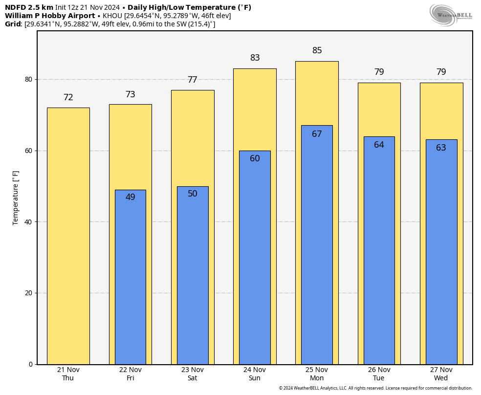
In brief: High temperatures on Monday and Wednesday will flirt with record highs before a front on Thanksgiving—likely during the morning hours—surges into Houston. This will bring us seasonal weather for the holiday, and likely keep us in a cool pattern well into December.

Late November heat

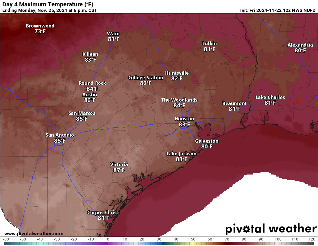
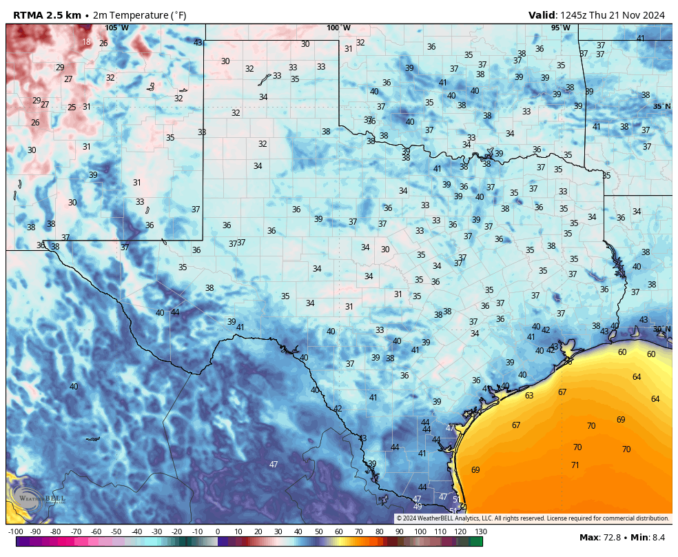
Sunday’s high temperature officially reached 83 degrees at Bush Intercontinental Airport, 1 degree below the all-time record of 84 degrees set back in 1910. Today should be slightly warmer across the metro area, with highs generally in the mid- to upper-80s. So the all-time record for today, 86 degrees (set in 1967) is definitely in play.

We could have one more chance to set a record high on Wednesday, when the daily record high is 84 degrees (set in 1989). The normal high temperature for this time of year, in case you were wondering, is 70 degrees. This November has a chance to be the warmest November on record, but a cold snap later this week could pull us back from the abyss. We’ll see.

Monday’s high temperatures will be sizzling in South Texas, with a front keeping North Texas cooler. (Weather Bell)

Fundraiser

This is the final week of our 2024 fundraiser. If you appreciate the work we do, the sanity in the storm, this is your chance to support our site by donating or buying merchandise right here. Those who donate are ensuring that our work will be freely available for all. Thank you to everyone who has supported us so far during this annual campaign!

Monday

With a persistent onshore flow today, we’ll see warm and humid conditions, with highs in the mid-80s for much of the area, and a few locations likely reaching the upper 80s. Skies will be mostly sunny, with a southerly wind at about 10 mph. As noted above, this is abnormally warm for this time of year, but a front is coming to bring some short-lived relief. I cannot entirely rule out a very isolated shower with the front this evening, but for the most part we’ll just see drier air moving into the region by around sunset, and during the evening and overnight hours. Low temperatures will fall into the 50s tonight.

Tuesday

Our weather will be seasonal on Tuesday, with mostly sunny skies, drier air, and highs of around 70 degrees. Winds will be from the north, and perhaps a bit gusty. As winds turn easterly and then southeasterly overnight, lows will fall to around 60 degrees as humidity starts to return.

Wednesday

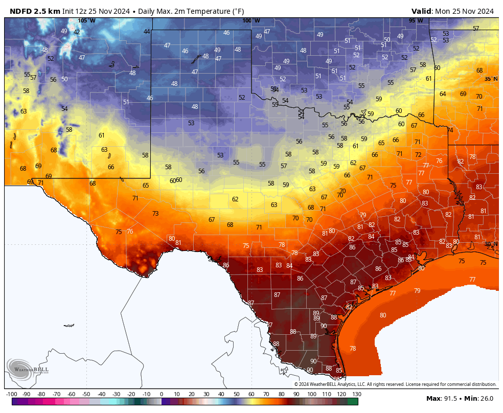
I’m going to make a bold prediction, and if I’m wrong I’m sure there will be plenty of people to point it out. However, I think Wednesday will be our last 80-degree day of the year. And it’s going to be a warm one, with highs in the mid-80s (and as noted above, with a record high in play). Mostly sunny skies will aid in the warming, and it will be plenty humid as well. Lows will drop into the 60s.

Thanksgiving

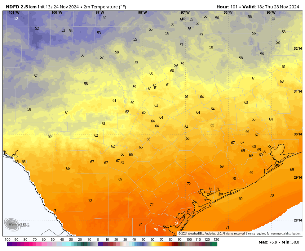
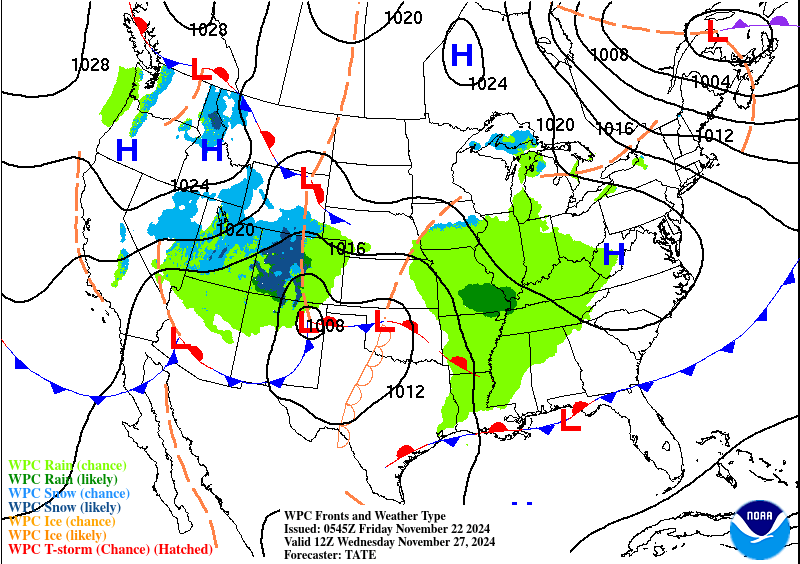
We can all give thanks that a stronger front will arrive in Houston on Thursday. The timing is still a little bit up in the air, but most of our modeling guidance suggests the front should reach Houston by around sunrise or shortly after. There is unlikely to be any rainfall with the front, but it will usher some stronger northerly winds into the area. We’ll likely see northerly gusts up to 20 or 25 mph. Skies start out mostly cloudy in the morning, but I expect some clearing during the daytime. Expect highs in the upper 60s for most locations, with overnight lows dropping into the 40s in Houston, with upper 30s possible for some outlying areas.

Friday morning will be rather cold. (Weather Bell)

Friday

Friday, or for some dedicated shoppers Black Friday, will be clear and cool. Expect a breezy and chilly morning. Skies will be mostly sunny, likely with highs in the low 60s. Temperatures on Friday night should fall to around 50 degrees in Houston, with colder conditions in outlying areas.

Saturday, Sunday, and beyond

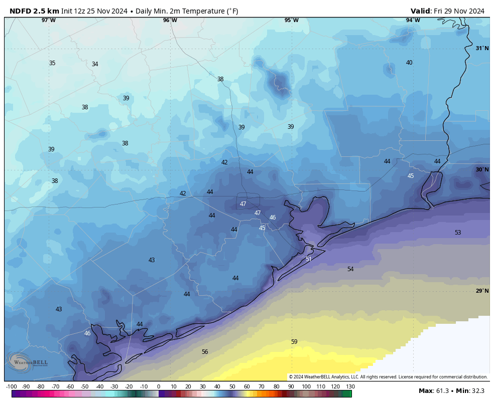
We’ll start to see a bit of a warming trend on Saturday, with highs probably in the upper 60s. However a reinforcing front (with a very slight chance of rain) is likely to keep a lid on temperatures. Highs on Sunday should be in the low 60s or thereabouts. Nights stay chilly.

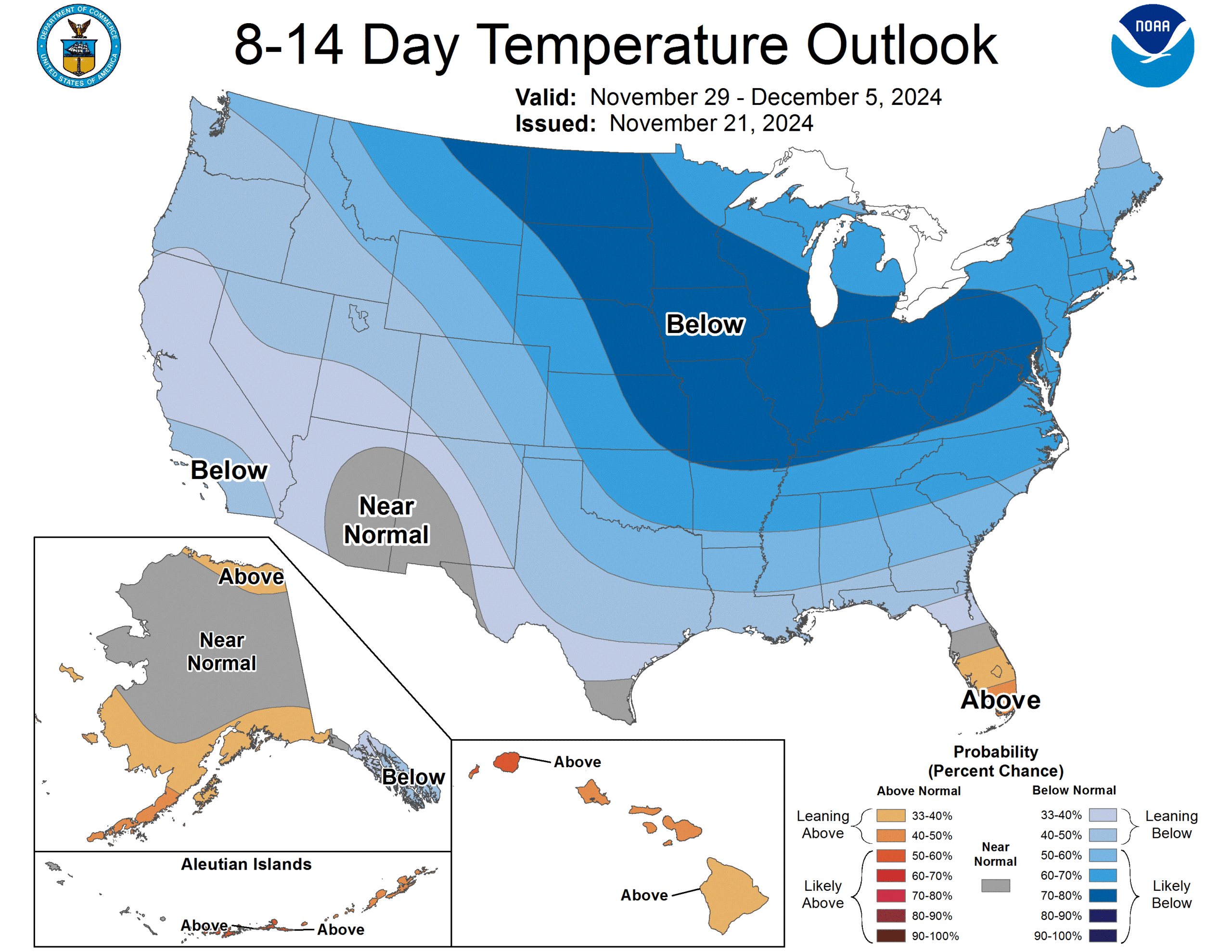
Most of next week will remain on the cooler side, with highs in the 60s, and lows in the 40s to lower 50s. Beginning Sunday night or Monday we’ll also see an increased chance of rain and cloudier skies. Alas it will be December by then, so I won’t be able to describe it as a cold November rain …

The forecast for Thanksgiving is finally coming into better focus

In brief: We’re increasingly confident that a fairly robust cold front will arrive on Thanksgiving Day in Houston, bringing colder and much more seasonable weather. The good news is that there is unlikely to be any meaningful rain with the front. Today’s post breaks down what to expect on the holiday.

Hi all, just jumping in on a Sunday because we’ve finally got a little clarity on the forecast for one of the most anticipated holidays of the year: Thanksgiving. For more than a week we’ve been waffling a bit on what to expect, but we’ve finally got a bit a clarity. Hence a weekend post to tell you what we know so you can prepare accordingly.

Weather leading up to the holiday

Today and especially Monday will be hot, very hot by late November standards. With temperatures in the mid to possibly upper-80s on Monday, we’re likely to break some records. A modest front arrives on Monday night to cool us down for Tuesday, but by Wednesday we’ll be trending warmer again with an onshore flow. Although our temperatures will be swinging around, we don’t expect much if any precipitation. So pre-Thanksgiving travel across Texas should be fine.

Noon-time temperatures on Thanksgiving will generally be pleasant. (Weather Bell)

Thanksgiving itself

A stronger front is coming on Thursday to Houston—flying in like a gaggle of turkeys, so to speak. If you live well inland, say in a place like Katy or The Woodlands, the front may already be moving in by sunrise. Or it may be a few hours later. So expect windy conditions, with gusts up to perhaps 25 mph from the north or northwest. Temperatures will be in the 60s, and likely remaining there throughout the day.

If you live in central Houston, or closer to the coast, it’s quite possible the front will lag a bit. So the morning may be warm and muggy, with temperatures in the 70s, before the front arrives during the middle of the day some time. But again, the story will be the same, with fairly robust northerly winds bringing in some drier air pretty quickly. This should be the kind of front you notice as it moves in. Lows on Thursday night should drop into the 40s, with continued breezy conditions, so keep that in mind if you’re going to be out late or up early Friday to go shopping.

Holiday weekend

The rest of the weekend looks to see partly cloudy skies, with highs generally in the 60s, and lows in the 40s. So it should feel like the holiday season. Rain chances look fairly low until early next week. We’ll have a full forecast for you on Monday morning.

Fundraiser

Just a quick word to say we’re still seeking support to fund all of our activities for the coming year. Head over here to donate or buy merchandise. Thank you so much to everyone who has donated so far.

Nice weather through Saturday gives way to near-record warm in Houston Monday

In brief: Houston gets another day or two of nice weather before a big warm up Sunday and especially Monday (near record highs). A strong front with details TBD looks increasingly likely sometime on Thanksgiving Day, ushering in a spell of colder weather next weekend.

We’ve got 10 days left in our annual fundraiser! You can see the ways to to donate or get merch here. Thank you all for your support!

Today and Saturday

It’s another cool morning, with Bush Airport down to the 40s and Hobby down near 50 degrees. Look for another spectacular day today, with highs into the 70s or upper-60s and plentiful sunshine. Much the same tomorrow but it’ll be a couple degrees warmer.

Sunday

By Saturday evening, winds will have turned around to come from the southeast, ushering back in humidity and allowing for a pretty decent warming trend. We should punch back up to near 80 degrees Sunday afternoon, after a morning in the 50s. You will notice a breeze during the day and the humidity start to pick back up some by evening. It’ll be mainly sunny once again, however.

Monday’s forecast highs are close to records for the date. (Pivotal Weather)

Monday and Tuesday

Monday’s forecast for mid-80s will come close to testing the record of 86° set back in 1967. Look for our warmest temperatures then. A weak cool front is likely to push through the region either Monday afternoon or evening. I suppose we could see a passing shower Tuesday morning, but overall this front looks relatively uneventful. Tuesday will be a bit cooler, however, with highs back in the 70s and morning lows in the 50s or low-60s.

Wednesday’s weather map shows a significant storm in Colorado with just a few showers to our east. Travel within Texas should be mostly fine. (NOAA WPC)

Wednesday

The big travel day. A storm system in the lee of the Rockies will begin to develop on Wednesday. Locally, this will lead to a significant shift back to onshore winds. It will be breezy and a bit warmer Wednesday again with more humidity. Along with this could be some passing showers or thunderstorms. Highs will be back near 80, with morning lows in the 60s. Travel to Colorado will likely feature significant weather and mountain snow. Travel to Louisiana or points east should be mostly fine. Travel within Texas looks mostly fine for now as well.

Thanksgiving Day and beyond

Models seem to be in agreement that the next strong cold front hits on Thanksgiving Day. The good news is that it looks relatively moisture starved here in Southeast Texas — for now. We’ll see if that continues. But the it will turn windy and sharply colder at some point either Thursday or in time for napping on Thursday evening it appears. Temperatures should fall into the 40s Thursday night.

Colder weather invades from the north late next week, blanketing much of the country in below average temperatures. (NOAA)

Colder weather will remain through the rest of the holiday weekend. I am guessing we’ll see a reinforcing shot of colder weather to follow Sunday or Monday before perhaps a more meaningful warming trend after the holiday.

Lows fall to just above freezing for some areas north of Houston, and are chilly across the region

In brief: Houston is experiencing its coldest night of the fall season so far, with temperatures dropping into the mid-30s in some inland locations. We’ll continue to see fall-like weather into Saturday before we warm up for a few days. If you’re wondering about the Thanksgiving forecast, it’s about as clear as plum pudding.

Plans for next year

As we continue our annual fundraiser (you can click here to find more information on how to donate, or buy merchandise), I wanted to talk a little bit about our plans for next year on Space City Weather. Here are some of our goals for 2025:

  • Update our flood scale with the latest social science research
  • Major overhaul of our iOS and Android apps to modernize their back end
  • Big, public celebration of our 10th anniversary
  • Additional partnerships with the community to support worthwhile projects
Sunrise temperatures were chilly across Texas this morning. (Weather Bell)

Thursday

Temperatures this morning range from the mid-30s in Montgomery County to the upper 50s on Galveston Island, which gives you some sense of the geographic diversity of the Houston region, and the challenge of forecasting weather across such a broad and diverse area. In any case, it’s the coldest night of the season so far, and you’ll probably want a sweater or jacket on the way out the door.

High temperatures today will reach about 70 degrees beneath sunny skies. Winds will be light from the north or northwest today. With dewpoints in the 20s this afternoon, the air will feel very, very dry for Houston. Temperatures tonight will be chilly again, but likely 1 to 3 degrees warmer than Wednesday night.

Friday

A day that will be a lot like Thursday, with ample sunshine and drier air. High temperatures will be a touch warmer, in the low 70s, with overnight lows dropping to around 50 degrees in Houston, with cooler temperatures for outlying areas.

Saturday and Sunday

As high pressure makes its way to the exits, we’ll see the onshore flow returning this weekend. Highs on Saturday will still hold in the mid-70s for most locations, with mostly sunny skies, and fairly low humidity. But overnight temperatures will only drop to about 60 degrees. The second half of the weekend will see the return of some clouds, a bit more humidity, and high temperatures in the lower 80s. The weekend looks rain-free, so any activities you have planned are good to go.

Our weather will be warm-ish heading into Thanksgiving. But what will it do for the holiday? (Weather Bell)

Next week

Trying to forecast the weather for next week really ruffles my feathers. That’s right, you’re going to get plenty of Thanksgiving puns right up to the holiday itself.

Monday looks warm, with highs in the mid-80s and a warm night. At that point a weak front may sag into the area—we’ll see if it has enough oomph to push all the way through—and this could knock temperatures back slightly on Tuesday.

A stronger front is probably coming later in the week, but whether that’s on Wednesday night, Thursday, or Thursday night is not something we can say for sure. And with the Thanksgiving holiday on Thursday, the timing really matters, especially since there is likely to be a little rain with the front. In any case, I’d expect daily highs to be around 80 degrees ahead of the front, and likely falling back to the 60s afterward. So yeah there’s a wide range of possibilities still on the table for Thanksgiving. Next weekend should be colder, however, with nights in the 40s or 50s.