Slight chance of storms as a cold front pushes into Houston this afternoon

In brief: Houston faces the slight possibility of some thunderstorms as a cold front pushes into Houston this afternoon, with drier air following. A stronger push of cold air on Wednesday will bring the coldest night of the season for most locations, making it feel more seasonal as we get closer to the holidays.

Low temperatures on Monday morning were 20 to 25 degrees warmer than normal. (Weather Bell)

November will feel more like November soon

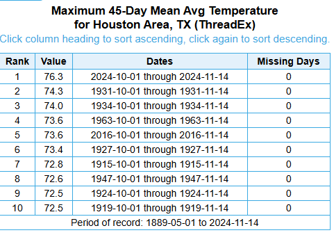
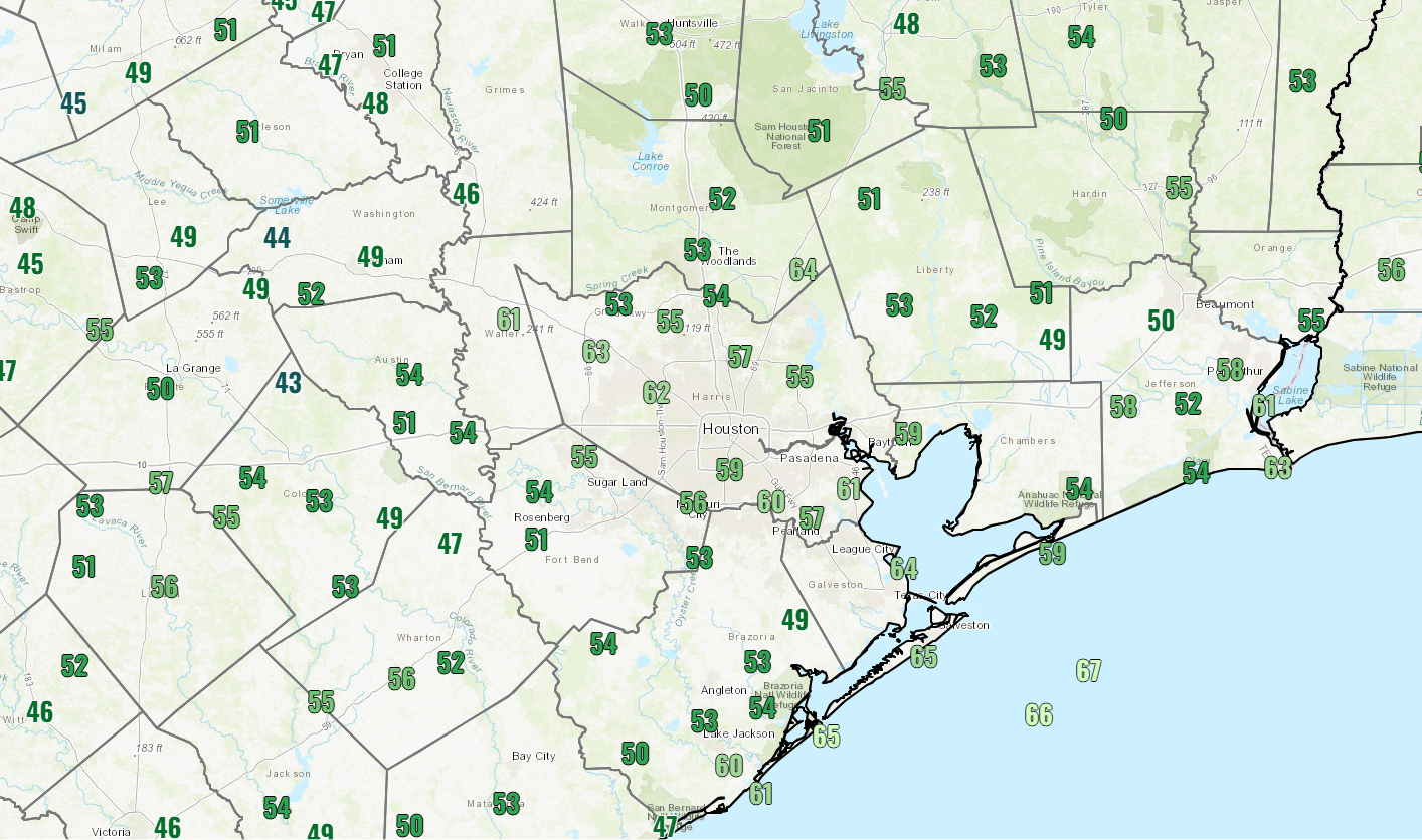
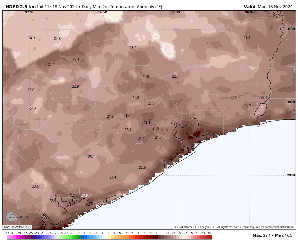
For mid-November it is an incredibly warm morning, with temperatures generally in the mid- to upper-70s. We are running about 25 degrees above normal for this time of year for morning lows. And if you’re thinking, golly, I’d like it to be feel a little bit more like the holiday season, you’re in luck as a front will arrive today. A push of colder air on Wednesday will make things downright chilly during the second half of the week. Also, please don’t forget that we’re in the midst of our annual fundraiser, during which your support keeps Space City Weather going all year long. You can find more information here.

Monday

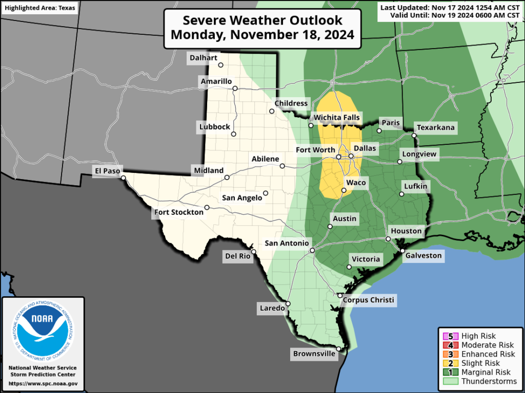
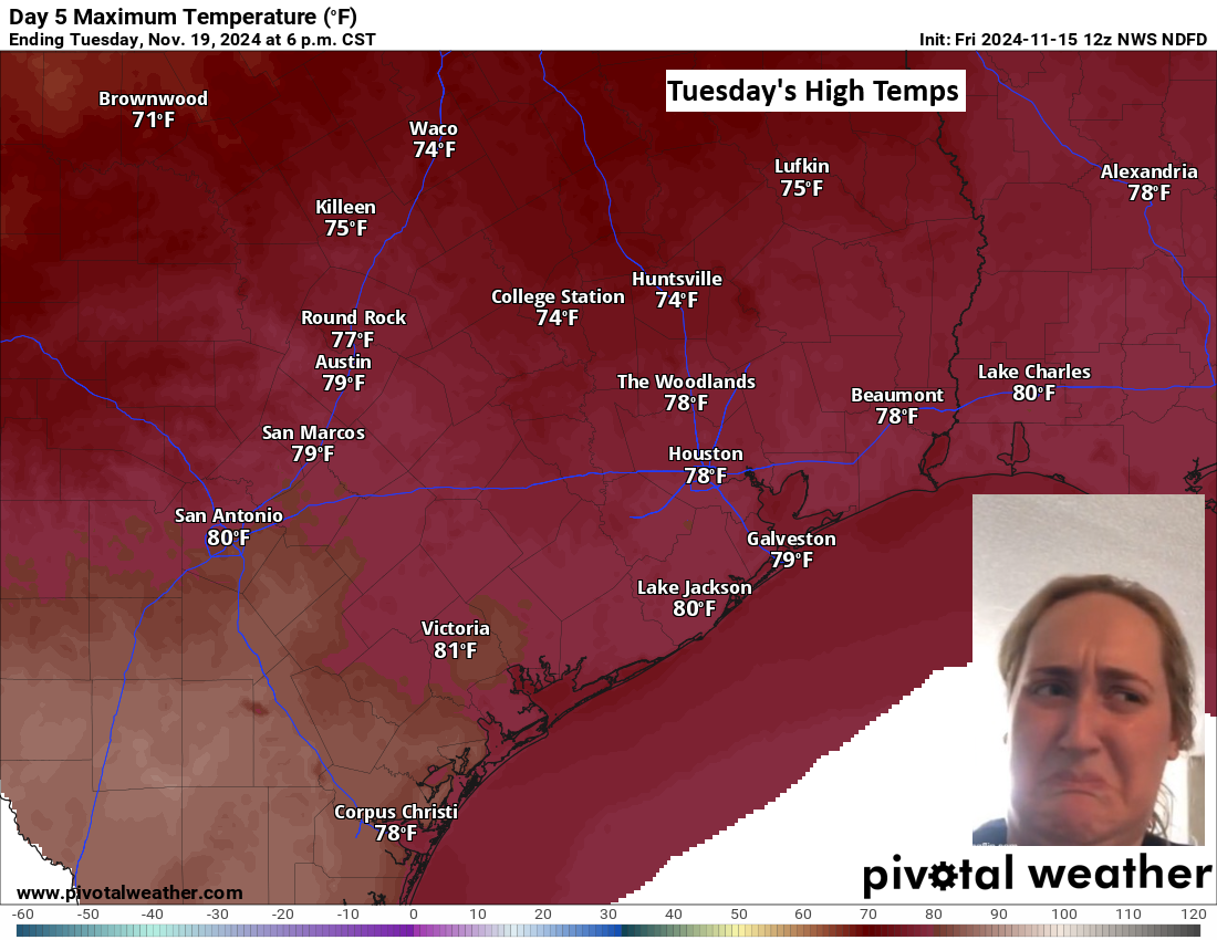
Houston will see scattered, mostly light showers this morning in advance of a front moving in from the west. Highs will reach around 80 degrees, or a bit above. A line of storms should push into western areas of Houston, including Katy, by around 2 to 4 pm. At this time it looks like this line of showers will be falling apart as it pushes into Houston during the next hour or two, but I’m not ready to entirely rule out some stronger thunderstorms and the possibility of damaging winds. Still, the overall threat from this frontal passage appears to be pretty low. The showers will be clear of the area by around sunset or shortly after, with somewhat drier air pushing in. Lows tonight will drop to around 60 degrees.

Tuesday

This will be a sunny day, with moderately drier air and light winds. Most areas should see highs in the upper 70s. Lows will drop into the 50s on Tuesday night, but the more noticeable trend will be stronger winds after midnight, from the northwest. This will herald the arrival of a secondary push of colder and drier air.
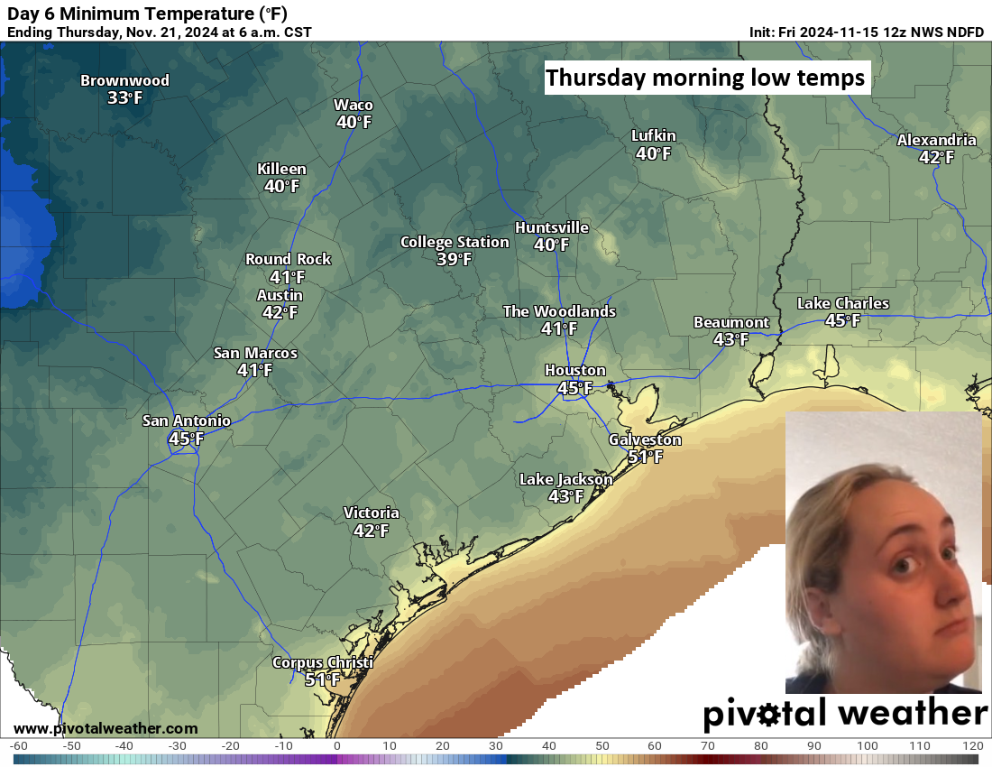
Wednesday

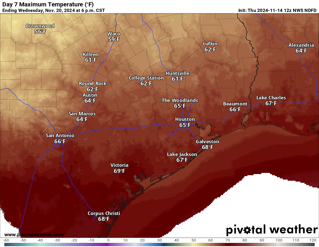
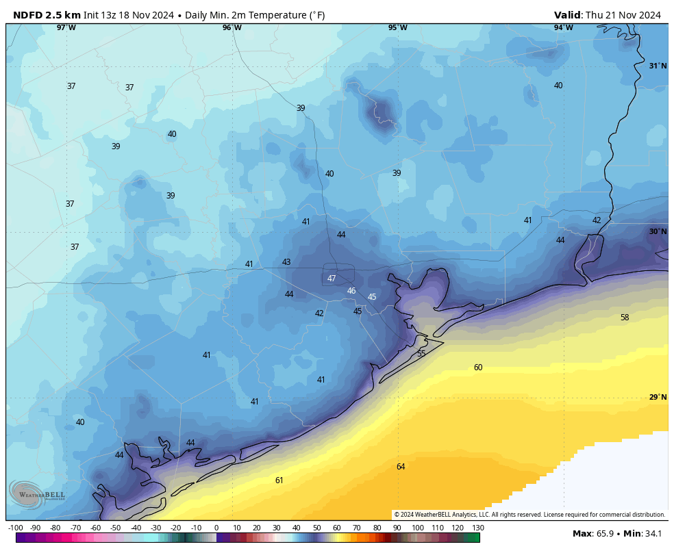
Said winds will peak during the early morning hours on Wednesday, gusting up to 25 mph or higher before relaxing during the afternoon or evening hours. Skies will remain sunny throughout. Lows on Wednesday night will generally drop into the 40s in Houston, and this should be the coldest night of the week.

Low temperatures will bottom out on Thursday morning. (Weather Bell)

Thursday and Friday

These will be pleasant and sunny days, with highs of around 70 degrees, and lows around 50 degrees with cooler conditions in outlying areas. Humidity will be low.

Saturday and Sunday

The sunshine party continues this weekend, and there are zero concerns for any outdoor activities you may have planned. Humidity will be on the upswing, but still quite a bit lower than is normal in Houston. Look for highs in the mid-70s on Saturday, and about 80 degrees on Sunday. By Sunday night lows will only be dropping into the 60s.

Next week

We’ll start out warm next week, but at some point a cold front should arrive. The timing for this front is critical, of course, with Thanksgiving on the horizon next Thursday, and the possibility of some rainfall with the front. In tomorrow’s post I will dig a bit deeper into the forecast for Thanksgiving Day in Houston, when hopefully there will be a little more clarity.

Training showers possible today, and thunderstorms on Monday ahead of a cold front

In brief: I hope everyone is enjoying their weekend in Houston, and we’re sorry to interrupt. But I wanted to give readers a heads up about the intermittent rain chances our region will face over the next 36 hours or so. We’re watching the potential for some minor street flooding today, and strong thunderstorms Monday.

The pattern for the next two days will be unsettled due to an advancing front that is running into very warm air over the Gulf of Mexico with plenty of moisture at hand. For the most part, the rainfall today and Monday will not be too disruptive. However, the atmospheric conditions are such that we could see some inclement weather, including the possibility of some strong winds on Monday.

Sunday

As of 8:30 am this morning, there is a line of showers running almost due north from Alvin and Pearland to Kingwood and Cleveland. We expect to see this kind of training pattern pattern today whereby some locations pick up in excess of 1 or 2 inches of rainfall under these bands, and most of the rest of the area only sees light rain. It’s possible there could be some minor street flooding where these bands establish themselves. Most of our guidance indicates significantly less activity over night, so showers should be on the wane by this evening. Highs today will reach the lower 80s for most locations.

Severe weather outlook for Monday. (NOAA)

Monday

On Monday the front itself will push into Houston, and we should see a line of showers and thunderstorms ahead of it. The timing is still a bit uncertain, but I’d expect the line to coalesce to the west of Houston by around noon, and push through during the afternoon hours. It should reach the coast by around sunset give or take an hour or two. This line will be moving fast enough that I don’t expect any major flooding problems, but for some areas there will be a period when it passes when thunderstorms are a bit gnarly. There is also the potential for some damaging winds, but the chances for tornadoes and hail are quite low. The rains will end quickly behind the front as drier air filters in.

Next week

Skies will clear out by Monday night, and we’ll see ample sunshine through next weekend. A shot of colder air arrives on Wednesday, and we should see a couple of nights in the 40s, which will be our coldest weather of the season. Look for full details on all of this in our regular post on Monday morning.

Fundraiser

I just wanted to mention that our annual fundraiser is ongoing for two more weeks. Your support is critical to the operation of the website, and all we do here at Space City Weather. More information on how to donate or buy merchandise can be found here.

A very atypical autumn for Houston will feel much more typical behind a pair of fronts next week

In brief: Houston will see gorgeous weather today and increasing clouds Saturday. Scattered showers are likely Sunday before the first of two fronts Monday. Winds will be gusty Sunday into Monday. It’s a second front Tuesday night that gives us the real cool stuff to close out next week.

Before we begin today, two quick housekeeping items. First, Galaxy Lights, presented by Reliant kicks off tonight! It finally feels a little more fall-like, so if you want to get yourself in a more festive mood, go check it out. And thanks to Reliant’s sponsorship of Space City Weather, you can get $5 off your tickets if you use code: GLSCW24!

Secondly, a reminder that our annual fundraiser continues. Y’all love the umbrellas and astronaut t’shirts. Thank you again for your support of the site!

Rankings of the warmest October 1-November 14 periods going back to the late 1800s in Houston. No year comes close to 2024. (NOAA)

Today and Saturday

The period between October 1st and yesterday has been the warmest on record in Houston for that range by a full 2 degrees, which over 45 days is pretty remarkable. We’re in the upper-40s officially this morning for the first time in about a month. This autumn has been anything but typical.

There will be lots of sunshine today with continued pleasant weather. Highs will top off in the mid-70s. Clouds will begin pushing in tonight and tomorrow, so look for less sun. Morning lows tomorrow should be in the 50s to perhaps near 60 degrees, while daytime highs will be near 80 degrees as long as we get a little sunshine.

Sunday

Isolated to scattered showers will begin to pop up late Saturday night and continue into Sunday. I don’t expect Sunday to be a washout right now, but there will be rain showers to dodge throughout the area and the day. Highs on Sunday should be in the low-80s after a very mild morning in the 60s or low-70s with increasing humidity. It will also be quite breezy on Sunday, with winds gusting to 25 mph or so, perhaps a bit stronger over the bays and at the coast.

Monday

The first volley in the transition to late autumn comes Monday with our scheduled cold front. There should be a line of thunderstorms that accompanies the front around midday on Monday. Some could have very gusty winds. Once those push east of the area, we’ll see a slow drop in humidity and slightly cooler weather. Ahead of the front, the morning will be breezy, but the wind will die off behind the front in the afternoon.

Rest of next week

Don’t be tricked by Monday’s front! Some folks will be quick to call “bust” with this, as Tuesday morning will only be in the 50s and Tuesday itself quite warm in the upper 70s.

Even though we’re behind a cold front, Tuesday will be quite warm. A reinforcing push of cold air Tuesday night and Wednesday morning will end this. (Pivotal Weather)

It’s a second front early Wednesday morning that ushers in the real cool stuff. Wednesday will probably struggle to get to the mid-60s for highs, with lows in the 40s and some pockets of 30s Wednesday night and Thursday morning.

Thursday morning will likely be the coldest morning of autumn so far. (Pivotal Weather)

Nice weather should continue into next weekend.

Tropics

Tropical Storm Sara made landfall in Honduras this morning. Rain totals in excess of 20 to 25 inches are possible in the northwest mountains there. Substantial rain is now likely in Belize over the next couple days as well.

Tropical Storm Sara will degrade into a depression or remnant low by early next week, but not before dumping copious amounts of rain on Honduras and coastal Belize. (NOAA NHC)

The good news is that Sara should degenerate into a remnant low next week and get swiped east ahead of the cold fronts that push into the Gulf. Never say never, but that should close the books on the 2024 Atlantic hurricane season.

Houston will actually feel like late autumn by next week

In brief: Houston will see pleasant weather through Saturday before humidity surges back with a breeze on Sunday. A narrow line of thunderstorms accompanies a cold front on Monday, but the truly cool to cold air will lag behind by a day or so, arriving Tuesday night. By Wednesday, we may limp into the mid-60s for highs. It will feel like autumn.

Just a quick reminder to folks that our fundraiser kicked off yesterday! We are grateful for whatever support you are able and willing to provide, and thank you to those that pitched in on day one! I have to admit that astronaut t-shirt is <chef’s kiss>. Thank you so much again!

Today

It has not been as cool as it was yesterday morning and this morning in three or four weeks. Whatever the case, temperatures are generally in the 50s this morning once more.

Temperatures are mostly in the 50s with a handful of 40s peppered in across the region this morning. (NOAA)

We’ll see highs punch up into the mid-70s this afternoon. A light jacket should do this morning if that’s your thing. Overall, today looks wonderful.

Friday and Saturday

Tonight should be even a bit cooler than we’re seeing this morning. Look for lows down to near 50 degrees in Houston which means 40s in many suburbs and outlying areas. Highs will poke into the mid-70s again tomorrow, followed by mid-50s for lows and upper-70s for highs on Saturday. Both days look mainly sunny.

Sunday

Humidity will slowly return on Saturday, but you won’t really notice it until Sunday. You will also notice the wind on Sunday. Onshore winds pick up, gusting at times to 25 mph or so, perhaps even a little stronger over the water. Morning lows Sunday will start off in the 60s to near 70, warming up into the 80s for highs.

Monday through Wednesday

The forecast gets a little trickier next week, particularly trying to time everything out. A cool front is going to likely crash through the area Monday. It’s still too soon to say what it will bring, but the model signals seem to be hinting at a broken line of thunderstorms or a very narrow line of heavy showers and gusty winds. I wouldn’t entirely rule out some severe weather Monday, but it’s not the most likely outcome right now. We’ll keep an eye on things.

Daytime highs on Wednesday really show the impact this front will have, as most areas will stay in the 60s. (Pivotal Weather)

In terms of temperatures, it gets a little wonkier. The coldest air will lag the front by a day or two. So with the front crossing Monday, look for lows back into the 60s Monday night. Tuesday will be warm, and it should be a bit less humid. High temperatures will be well into the 70s to near 80 degrees. Then on Tuesday night, our first dose of colder air arrives, knocking us back into the mid-50s. And on Wednesday, even with oodles of sunshine, we will probably only do mid-60s at best. We’ll likely follow that with 40s Wednesday night and some wind to make it feel even colder. We may do 60s and 40s for a few days in a row, so it will feel more fall-like about a week before Thanksgiving.

Tropics

There remain no concerns from Potential Tropical Cyclone 19 (likely Sara later today) for Texas. Fronts will keep us safe. But PTC 19 is going to deliver some pretty rough weather to Central America, particularly in coastal Honduras, where upwards of 20 inches of rain is possible.

While not a concern for Texas, if you’ll be traveling to the Yucatan, Belize, or Honduras over the next week, you may need to adjust those plans accordingly. (NOAA NHC)

If you have trips planned or family back in these areas, keep an eye on Sara once it forms. There will likely be serious flooding in portions of Honduras, and if the storm wobbles offshore longer, they could also be dealing with a hurricane down there. Eventually this turns north toward the Yucatan, probably late in the weekend. It will then get caught up in the big cold front next week and kicked toward Florida. If there is good news, the odds of a major hurricane striking Florida are quite low now. Look for more at our companion site, The Eyewall in a bit.