Historically, this is when the Atlantic tropics really start to come alive

In brief: Today’s post discusses how this time of year is normally when the Atlantic tropics really start popping off. Also, Houston is going to see a very hot and mostly sunny week, which is fairly typical for mid-August.

Hurricane season snapshot

This has already been a very active Atlantic hurricane season. Although there have been just four named storms so far, two of them have become hurricanes, Beryl and Debby. Beryl is the most notable storm so far, reaching Category 5 intensity two weeks earlier in the Atlantic season than any previous storm on record. It also struck the greater Houston area, of course, causing widespread power outages and significant tree damage.

The Atlantic hurricane season typically sees more activity from now through mid-October. (NOAA)

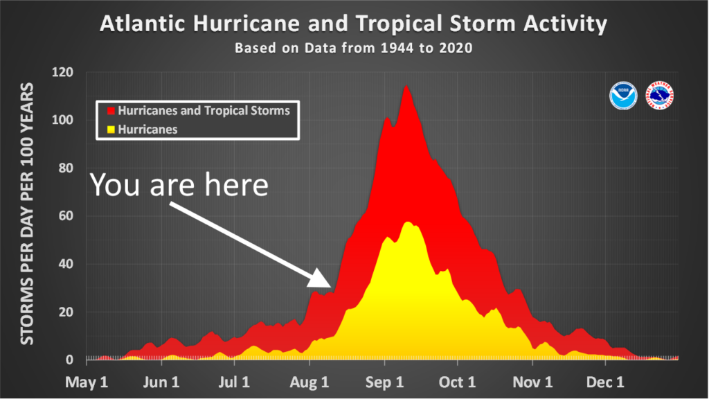
However, the reality is that during a typical hurricane season, about 90 percent of activity (as measured by the duration and intensity of tropical systems) comes after August 10. This can be seen in the image above, which shows the number of active storms, by day, across the previous eight decades. Historically we really start to see activity take off at this time, and remain very high for the next couple of months.

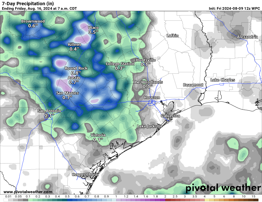
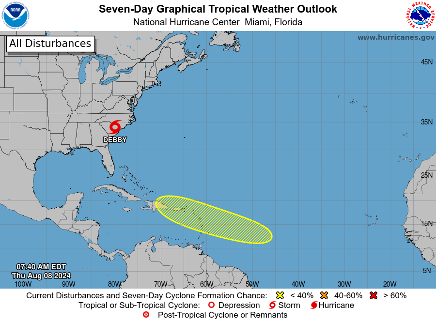
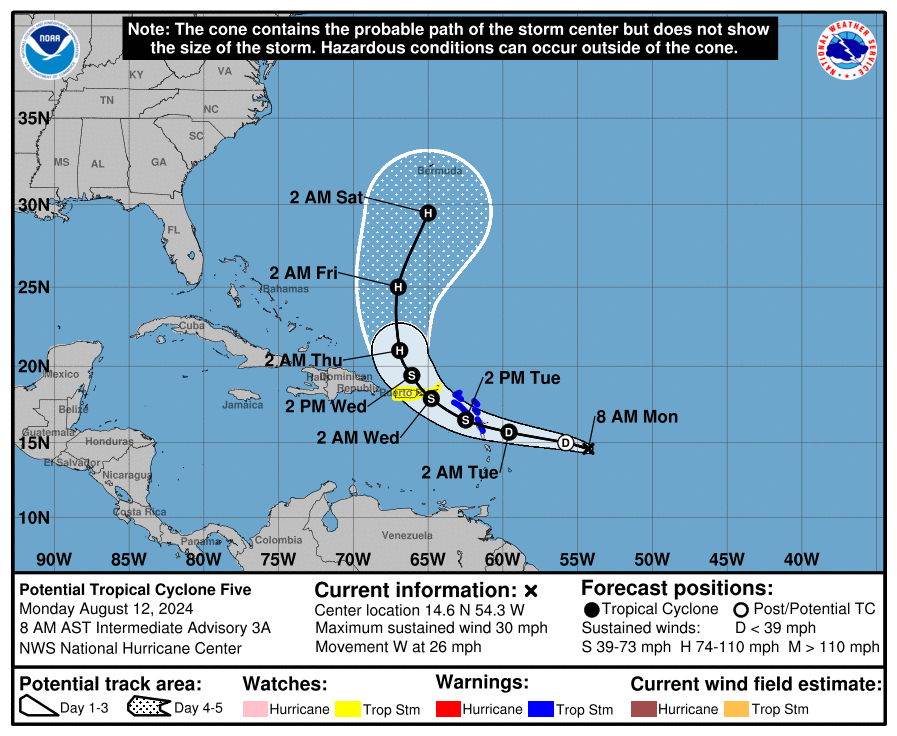
And right on cue we have Tropical Depression Five in the Atlantic Ocean. This storm is definitely not a concern for the Gulf of Mexico, but could threaten Caribbean Islands such as Puerto Rico before turning north and possibly striking Bermuda. The good news from our perspective in Texas is that after this storm—which would be named Ernesto—the Atlantic tropics could quiet back down for a short while. Looking at available model data, we’re not yet seeing evidence for a flurry of storms through mid-August, although that certainly could change by the final week of August.

Soon-to-be Tropical Storm Ernesto is not coming to the Gulf of Mexico. (National Hurricane Center)

August countdown

Speaking of August, my choice for the worst month of the year in Houston, there are 20 days left until the beginning of September.
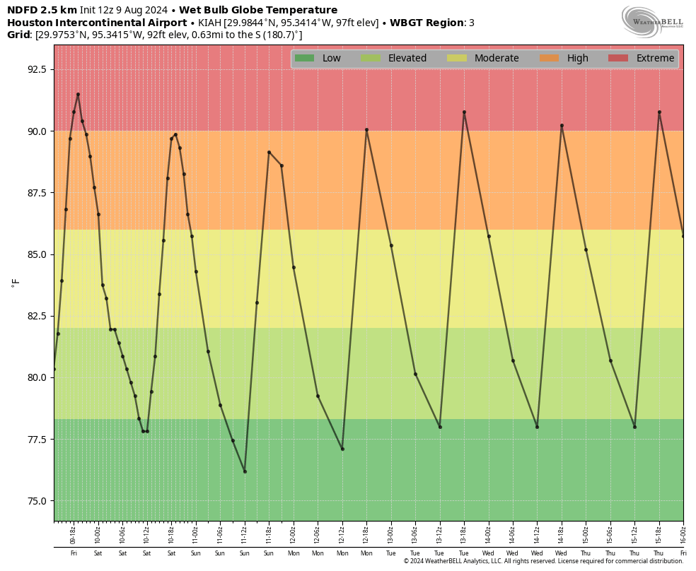
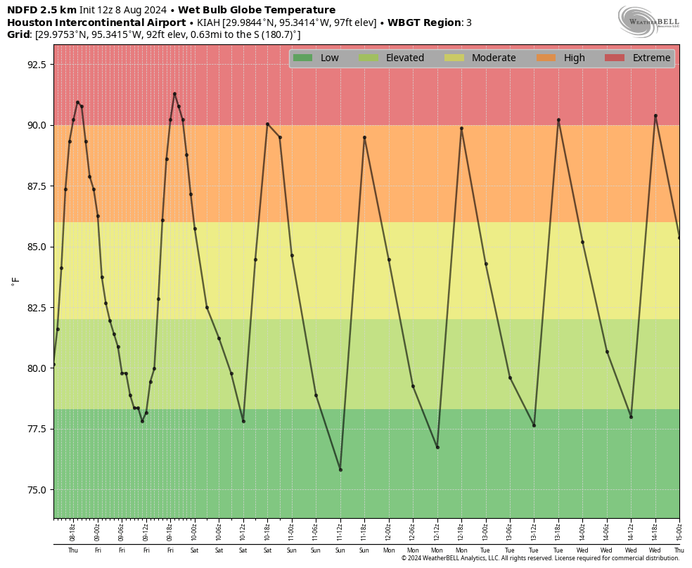
Monday

After some slightly drier air over the weekend—and you have to be a real connoisseur of humidity to have noticed it, but it was there—dewpoints will be back in the upper 70s today. This additional moisture in the atmosphere may help to squeeze out a few showers along the sea breeze this afternoon. But you’ll be lucky to be hit by a shower. I’d peg chances at about 20 percent south of Interstate 10, and 10 percent or less further inland. For the most part it’s simply going to be hot and mostly sunny, with temperatures generally in the upper 90s. Winds will be from the south to southeast at 5 to 10 mph, with slightly higher gusts during the afternoon and evening hours. Lows tonight will drop to around 80 degrees.

Houston will see ‘extreme’ heat for much of this week, so please take care outside during the late morning and afternoon hours. (Weather Bell)

Tuesday through Friday

We can pretty much Ctrl-C, Ctrl-V Monday’s forecast for the rest of the week, which is to say each subsequent day is likely to be a copy of the former: Hot, mostly sunny, and with slight rain chances.

Saturday and Sunday

The only change for our weekend forecast is that, instead of temperatures in the upper 90s, we’ll see highs of around 100 degrees. Thanks, mid-August! I don’t see much impetus for a pattern change any time soon, sorry.

Houston now looks to remain under the grip of high pressure and hot August weather into next week as well

In brief: August will continue to August in Houston, with hot weather, hazy skies, high humidity, and at least some low-end shower chances. We will continue to see the heat persist into next week, but that will also hopefully shield us from any tropical troubles.

Today

More of the same continues today, but this time we may add a slightly better chance of a few showers or thunderstorms this afternoon. The setup is a bit complicated, but we have a couple boundaries headed our way, and this coupled with daytime heating and the inland moving sea breeze off the Gulf could help at least fire up a few thunderstorms around the area. Otherwise, it’ll be another scorcher with highs near 100, heat advisories, and air quality alerts for high ozone.

Weekend

More of the same. There will continue to at least be subtle rain chances this weekend, but consider yourself lucky if you get a downpour. Highs will be in the upper-90s, with more borderline heat advisory criteria. I guess that’s a little cooler? I don’t know. Cooler or not, it’s still going to be hot.

Next week

We’ll keep this simple today: There may be some subtle nuance day to day in terms of exact temperature or exact shower chances, but the majority of next week looks stable and hot. High pressure is in control (more below), and that means sun, highs near 100, and heat index values pushing heat advisory criteria daily.

Temperatures will likely be in the lower edge of “extreme” next week, with only subtle day to day variability. (Weather Bell)

While we cannot entirely rule rain out of the forecast next week, daily chances really look meager right now. This is as reminiscent of last summer as we’ve seen so far this year.

Rain totals over the next 7 days are…well, they’re not going to add up to much. (Pivotal Weather)

The reason for all this is that high pressure in the upper atmosphere, something that’s been relatively absent this summer over Texas is finally locking into place. We usually see this at times during summer leading to more concentrated “heat wave” type periods. Well, it’s coinciding with August and our worst heat this year it seems. As long as this stays in place, which it looks to do for the most part over the next 10-12 days at least, we will continue with a pretty stable forecast. If you look at the map below, just notice the “594” circle over Texas. That’s a pretty strong sign of good heat and mainly dry weather in Texas in August.

High pressure looks dialed in over Texas for the next 10 to 12 days without much relent. (Tropical Tidbits)

The upshot of all this is that it would likely keep us protected from any tropical nonsense, so long as it stays in place. We’ll see if that’s the case. Check The Eyewall later this morning for the latest on the next Atlantic wave, which we currently believe will stay east of the Gulf.

Houston’s heat continues, but at least there are a couple of silver linings

In brief: Houston’s heat and humidity continue, pretty much without change, for the time being. In the spirit of optimism, in today’s post I identify a couple of silver linings to the ongoing August weather.

Small victories

Houston continues lie under the influence of high pressure, and while there will be some subtle changes in the days ahead the big picture of heat and humidity remains more or less the same. This is fairly typical for August, and there are a few upsides. One is that, with the lack of rain of late, the incredible surge of mosquitoes we saw in July has abated some. And secondly, for as long as there is high pressure in place, it should steer any tropical activity away from us. Even so, these are small victories when the weather is this sultry.

Based on the wet bulb globe temperature, yep, it’s gonna be very hot. (Weather Bell)

Thursday, Friday, and Saturday

The current heat wave will peak over the next three days, with high temperatures likely to reach 100 degrees for much of the metro area. We won’t get much, if any relief from winds, which will range from calm to maybe 5 mph. Skies will be sunny, with high humidity. Low temperatures will briefly get down to about 80 degrees overnight. Please take care if you’re going to be outside during the middle of the day.

Sunday

The second half of the weekend isn’t going to be much different. It will still be hot, sunny, and humid. Rain chances will still be near zero percent. However, temperatures for most of Houston probably will not reach 100 degrees. So we’ve got that going for us, which is nice.

Next week

There won’t be a whole lot of change next week. Skies should still be sunny, for the most part. Highs likely will range from the mid- to upper-90s. I don’t want to say rain chances are zero, because they’re not. But they’re quite low, in the 10 to 20 percent range for most days. Perhaps they’ll be a little bit higher by Friday or Saturday, but one has to squint really hard into the available data to see that.

Tropical outlook from the National Hurricane Center.

Tropics

Tropical Storm Debby has moved back inland into the southeastern United States, where it will continue to produce heavy rainfall and flooding in the Carolinas, before bringing the same to Virginia and the northeastern United States in the coming days.

Beyond Debby there is a new wave that forecasters at the National Hurricane Center are tracking. Most of our model guidance indicates this wave will turn northward before threatening the Gulf of Mexico, but given the time of year we’ll keep an eye on things just in case.

Houston will feel the heat through Saturday before some slight relief arrives

In brief: High pressure has hold of our weather, and that only means one thing for Houston in the summer: Heat. We are going to be hot and sunny for the next few days, before slightly cooler weather arrives next week with a smattering of rain chances.

A word about short forecasts

We don’t believe in wasting your time. So when there’s a lot to write about the weather, we’ll go into detail. And when there’s not, there’s no reason to. Such is the case in August when we’re under the influence of high pressure. And so the forecast today—and probably for the rest of this week!—is likely to be short and sweet. Well, maybe not so sweet.

Wet bulb globe temperatures in Houston will be at ‘extreme’ levels during the afternoon hours for the next few days. (Weather Bell)

Wednesday

Houston’s official high temperature, measured at Bush Intercontinental Airport on Tuesday, was 98 degrees. We’ll probably reach that mark or go a bit higher today as inland parts of the Houston area touch triple digits. Areas right along the coast will be a few degrees cooler. We’ll continue to see sunny skies, with calm winds in the morning and southerly winds of 5 to 10 mph in the evening. Lows tonight will be in the vicinity of 80 degrees.

Thursday through Saturday

Our present heat wave is likely to peak during this period, with high temperatures of 100 degrees likely for much of the Houston area. Winds will continue to be light, with lows only falling to 80 degrees. Skies will be sunny.

Sunday and next week

As high pressure starts to retreat slightly, we’ll see temperatures come down just a bit. On Sunday we’re still going to see sunny skies, but highs likely will only rise into the upper 90s. Later next week, perhaps starting on Monday, we’ll see some slightly better rain chances. Skies are still going to be mostly sunny, but the sea breeze may help to promote some afternoon showers. In terms of chances we’re probably looking at something on the order of a 10 to 30 percent chance into the middle of next week. So it’s not much, but it’s not nothing in mid-August, either.

The temperature outlook for later next week still calls for above normal conditions, but not as extreme as this week. (Pivotal Weather)

Tropics

As anticipated, Tropical Storm Debby has moved off the the South Carolina coast into the Atlantic Ocean where it may strengthen some during the next 24 hours. However, the primary threat from this system remains very heavy rainfall, initially in the Carolinas and eventually on into Virginia and Pennsylvania.

Beyond Debby, things look to remain quiet for the next week or so, which is a fine place to be heading toward the middle of August.