Snow ends, sun returns, let the great melt of 2025 in Houston commence

In brief: Sunshine and slightly warmer temperatures in Houston this afternoon will allow for substantial melting of snow in the area, but very cold temperatures tonight will allow for a refreeze to take place, likely creating very hazardous driving conditions, possibly worse than today. But melting will resume after mid-morning Wednesday, and a top tier Houston snow event will fade into the history books.

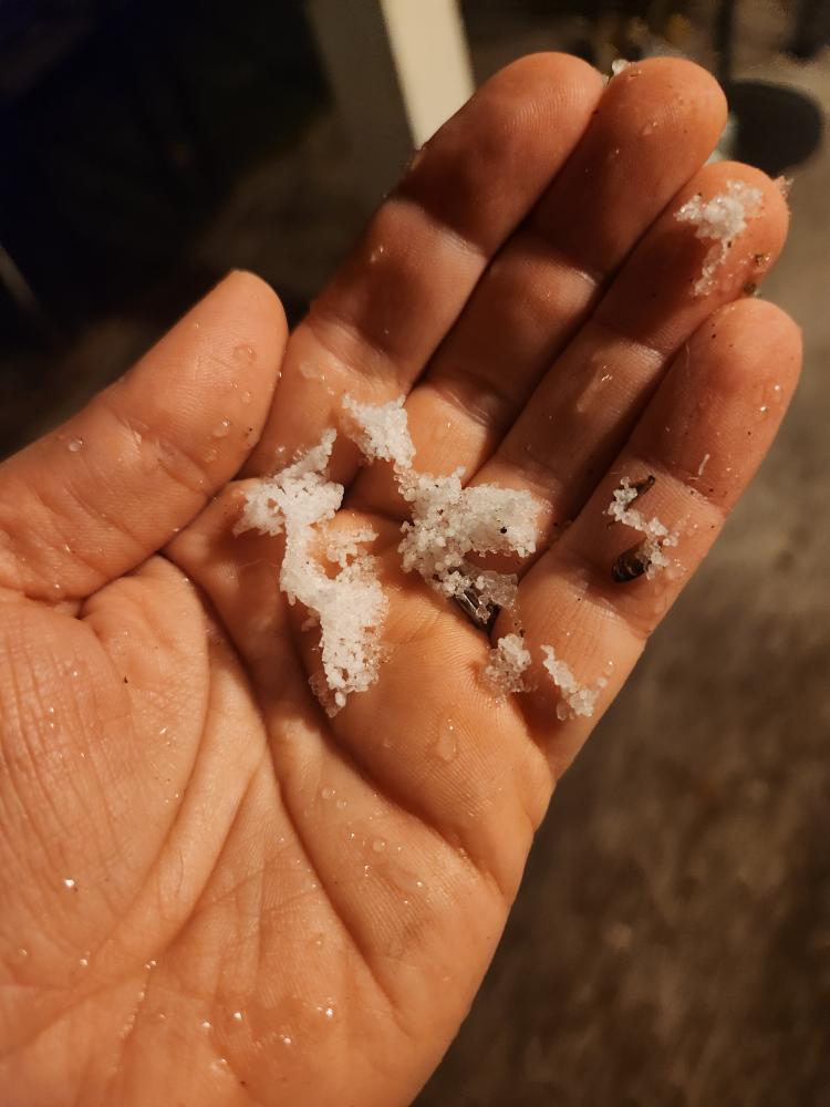
Well, you did it Houston! You have witnessed one of the largest snowstorms in our history. We will await official numbers and do a rundown for you on that tomorrow. As of 10 AM, Hobby Airport had recorded 3″ of snow, making it the third largest snow on record there (fourth if you count the unrecorded 1895 storm). Officially at Bush Airport, it would probably be a top 10 storm, but exactly where it falls I’m not sure. Here on the border of Houston and West U, I can state we got 4 inches. Eric down near League City saw about 2 inches.

Snow totals as of 10 AM; a more refined map will be issued later. (NWS Houston)

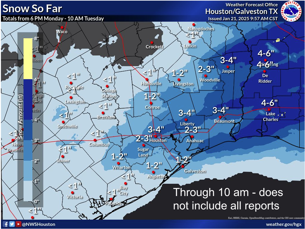
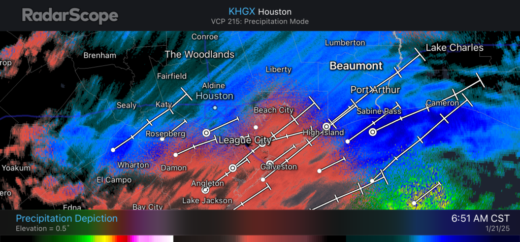
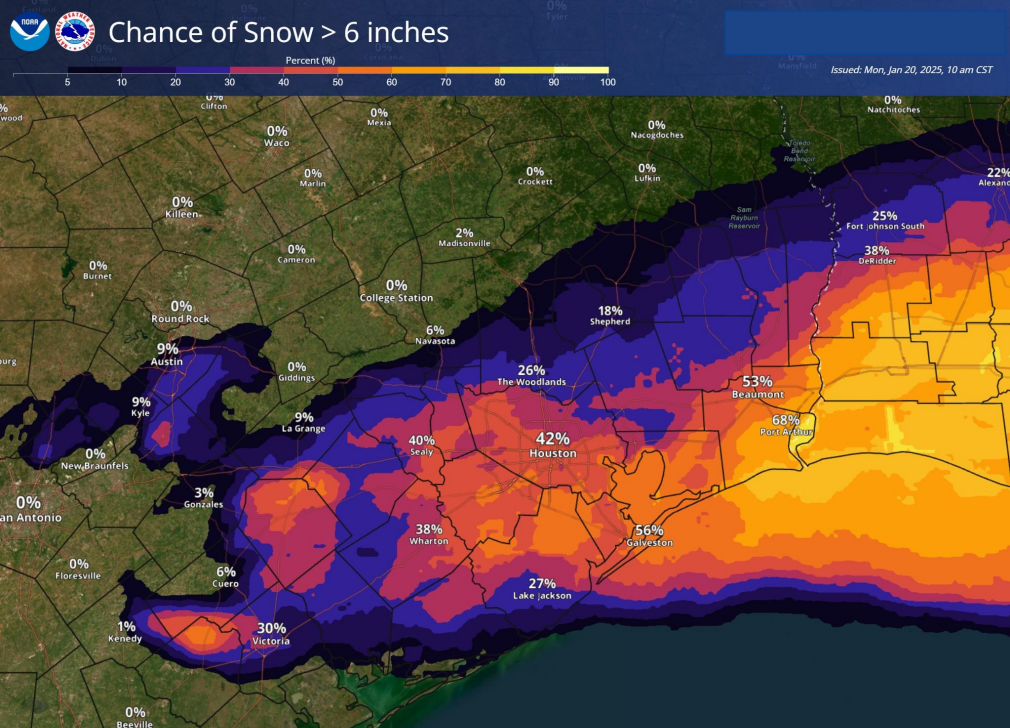
From the map, you can see that there was clearly a band from about Bellaire through Liberty County to just north of Beaumont and another from Bolivar into Sabine Pass. Those tended to be the champions of the storm. Vidor near Beaumont saw 6 inches, Baytown about 5.5 inches, and El Lago over 4 inches. Lake Charles ended up just shy of 5 inches, the third biggest snow on record there. The Atchafalaya in Louisiana was particularly hard hit with Lafayette’s 8 inches their biggest snow since the great 1895 storm. Rayne, which set the Louisiana state record in the 1895 storm with 24 inches saw 10.5 inches this time. New Orleans only saw 4 inches officially, but it makes it the largest modern snowstorm there on record.

We’ll have a full photo roundup coming soon. In the meantime, get your fix and follow us on our Instagram page.

Alright, so what now?

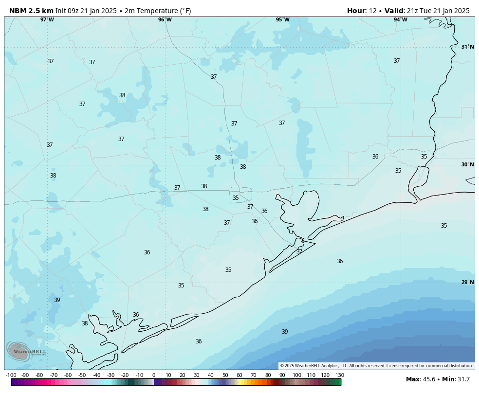
First, the sun’s out. Enjoy the snow while we have it. The Houston sun angle will go to work on this. Expect to see a good bit of melting today, especially on the roads and solid surfaces. Snow will melt less aggressively on the grass, so you’ll likely still get some time to play tomorrow morning. The big melt starting this afternoon will cause us problems tonight. All that muck on the roads is going to refreeze. And that may occur as early as 7 or 8 PM. It’s possible that road conditions may be worse tonight than they have been today due to ice. So use extreme caution if you have to go out tonight. Especially as temps drop into the 20s area-wide.

It will be quite cold tonight across the area. (Pivotal Weather)

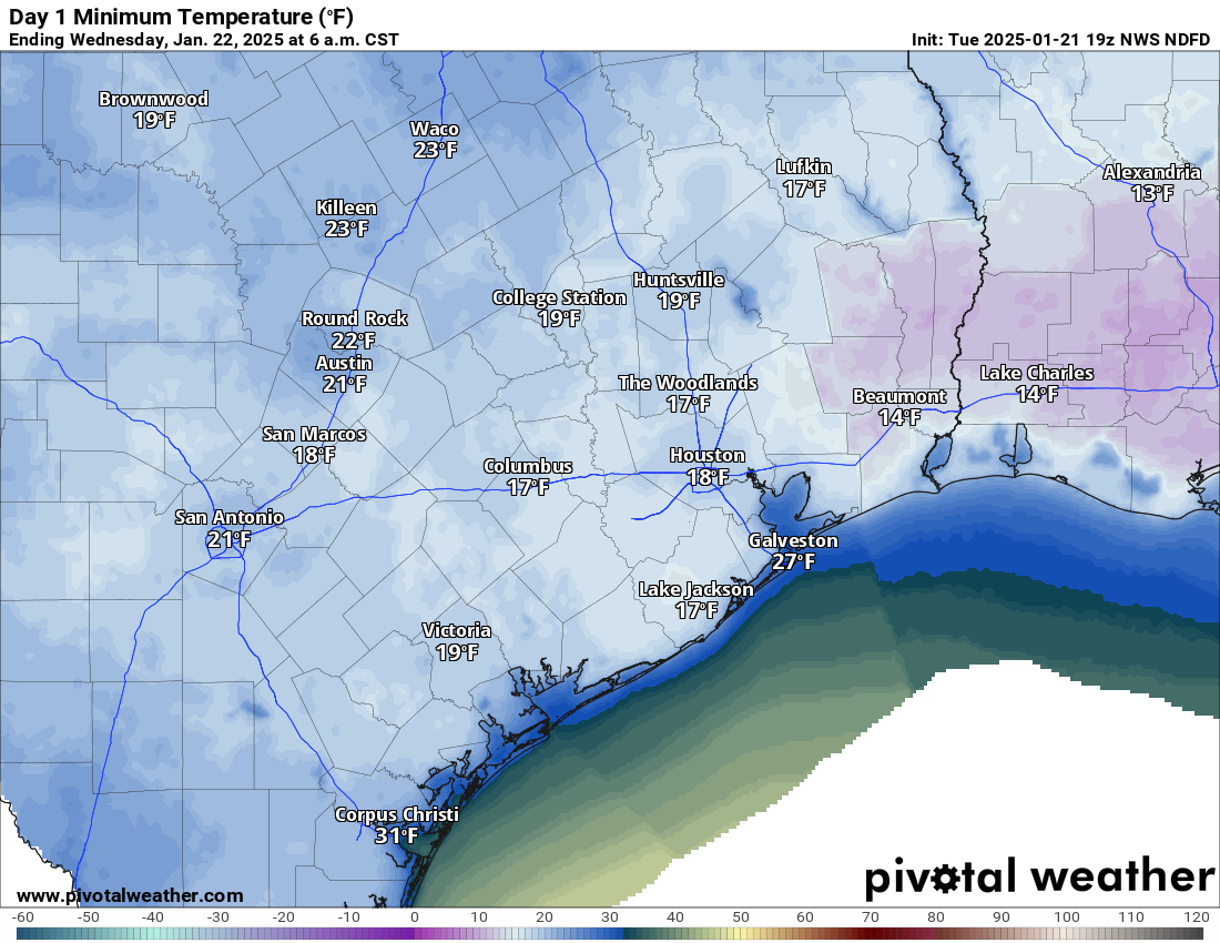
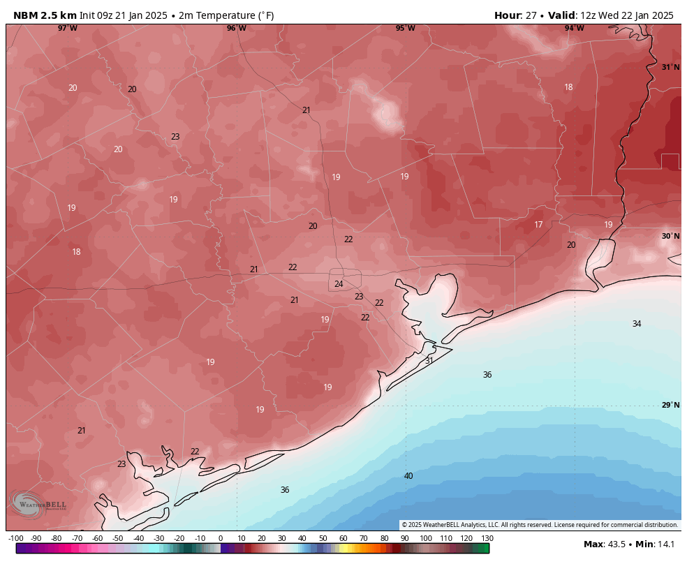
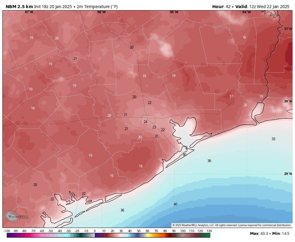
How cold will it get? Admittedly, models have tended to overforecast cold in recent cold snaps. In other words, they’ve gone too cold relative to what we actually saw. This may be different, however. With fresh snow on the ground in much of the area, that gives a “power-up” to cold conditions. Basically, if you have little snowpack left after today, expect lows in the 20s. If you have your ground mostly covered still, expect teens. The lows will vary widely across the area. An extreme cold warning is in effect for the region, underscoring that this won’t be anywhere near normal for us. Implement your maximum cold weather protection plans for pipes, plants, pets, and people tonight.

Temperatures rebound to the 40s tomorrow afternoon, and that should melt most of the rest of the snow except in shaded areas. Thursday morning’s commute may still feature patchy ice, but it will be navigable. Just use caution. Look for our photo roundup a little later today and our regular update in the morning.

Snow, sleet, and ice covering Houston roadways as winter storm moves through

In brief: A winter storm has brought a mixture of precipitation to Houston overnight, including snow and sleet. This wintry precipitation will end later this morning, and we will see some sunshine and above-freezing temperatures this afternoon before a very cold night.

Storm status

The Houston region has received a mix of snow, sleet, and other forms of wintry precipitation during the overnight hours, setting up slick conditions on Houston area roadways. Total snow amounts have varied widely, from a fine dusting of ice and sleet in some locations to 3 inches or more elsewhere.

Houston radar at 6:51 am CT shows a mix of snow (in blue) and sleet or graupel (reddish colors). (RadarScope)

Additionally, it is quite cold outside this morning. Air temperatures are generally in the mid- to upper-20s for most of the Houston region. However the addition of brisk northerly winds, gusting up to 25 or even 30 mph from the north, have made it feel like it is in the teens outside.

With temperatures now well below freezing for much of Houston, what is falling is largely sticking to area roadways that have been untreated with salt. There are dozens of reports of ice on area freeways, feeders, and major roadways, some of which are shut down. You can track an list of Houston-area icy roadways on Houston Transtar.

In short, for some areas it is a winder wonderland outside, for some a sleet-fest, and for all a dangerous time to be outside. Please do stay home this morning if it is at all possible.

Tuesday

The latest modeling indicates that the precipitation we are seeing this morning will exit to the east by 9 or 10 am CT. We should then see some clearing skies early this afternoon across Houston, including the coast by later this afternoon. This sunshine should push temperatures toward the upper 30s, allowing for some of the ice and snow on the surface to melt.

Additionally, the combination of sunshine and windy conditions (from the north at about 15 mph) should begin the process of sublimation. Sublimation occurs when snow transitions directly into water vapor, without first becoming liquid water. I’m writing all of this because it is possible that some roads will become clear and dry this afternoon, especially for locations further from the coast where there will be a longer period of sunshine to work with.

Temperatures should get into the mid- to upper-30s on Tuesday afternoon. (Weather Bell)

This matters because temperatures are going to freeze again tonight. So if there is moisture on roads, it will freeze into ice tonight, and into Wednesday morning. This could lead to black ice or situations in which there are patches of icy, dangerous roads tonight.

The temperature tonight at your location will depend on how much snow cover remains. That’s because new snow has a very high albedo (up to 0.95 out of 1), which means it is highly reflective of heat (radiation) back into space. So locations where there is a snowpack tonight will be 5 or 10 degrees cooler than areas with “darker” surfaces not covered by snow.

Over the last couple of days we have watched as forecast models have really struggled with how cold temperatures will get in the Houston region on Wednesday morning. As a best guess, areas with a layer of snow may drop into the mid-teens tonight, and areas with less or no snow are likely to only fall into the mid-20s or so. My sense is that most of Houston probably will end up in the lower 20s, but we shall see.

Current forecast for low temperatures on Wednesday morning. (Weather Bell)

Wednesday

After a cold start, high temperatures on Wednesday are expected to reach 40 degrees or even a little warmer under sunny skies. The combination of mostly sunny skies and sublimation should allow for roads to mostly dry out, but for some locations this may not happen until after noon. I realize the uncertainty is no fun, but such snow and ice events are relatively rare in Houston, so we are working on limited data about local roads and their response to icy conditions. Most of Houston will fall into the upper 20s on Wednesday night.

Thursday

A little warmer, with highs generally in the upper 40s to go along with mostly sunny skies. A light freeze is likely Thursday night.

Friday

Expect more sunshine, with highs in the 50s. Some inland areas may see a light freeze on Friday night, but most of us should be in the mid- to upper-30s.

Saturday and Sunday

Expect highs in the 60s this weekend, with nights only in the 50s as a warmer pattern returns. Saturday looks OK for outdoor activities, but rain chances start to increase by Sunday into next week.

Update schedule

We will have an update for you early this afternoon, by 2:30 pm CT, and again this evening to offer the best possible forecast for temperatures and roadways on Wednesday morning.

Storm getting underway with a potpourri of precipitation types across the Houston area

In brief: Houston’s forecast appears mostly on track, with a definite trend toward the heaviest snow and sleet emerging south and east of Houston by Tuesday morning. Accumulations may be as high as several inches under the most persistent bands, with a general coating to few inches elsewhere. Winds will gust near the coast Tuesday morning as well, and a very cold night still looks on tap tomorrow night.

Happening now

Well, our much advertised winter storm is underway across the Houston area. We’ve seen reports of sleet, graupel, rain, and snow across the region. We seem to be settling down into a tiered setup now with snow and sleet north and west, sleet and graupel in the lighter precipitation, and sleet and rain near the coast.

A radar image from 9 PM with annotated precipitation types shown. The mostly snow vs. mostly sleet line is across the northwest portion of the region. (RadarScope)

That area of snow and some sleet occurring north and west of Houston is going to gradually fill in and drop south and east through the night. As it does so, we’ll pick up some accumulating snow. As it gets closer to the coast and the potential for banding gets underway, that’s when we may see locally heavy snow anywhere from I-10 southward to the coast.

Forecast for the night

So before 3 AM, look for this potpourri of precipitation types. Again, plain rain should be expected in spots near the coast especially. This is not a surprise and was anticipated ahead of time. After 3 AM, there will be a transition to all sleet and snow and eventually just snow. There is a good chance we will wake up to snow falling tomorrow, although how much on the ground is an open question with a few possibilities. Snow should end from northwest to southeast after 9 AM tomorrow.

Why have we been kind of cagey on snow accumulation numbers?

Those that read us closely can tell we’re throwing out various accumulation numbers based on model data and National Weather Service forecasts but we’re not exactly confident. Now, the event is underway so we should be highly confident, right? Not right. The SREF is a short-range ensemble model, meaning it’s run multiple times with varying snapshots at the beginning to produce a more realistic spread in outcomes. Basically, we want to see how bad or not bad it can get. As of the 3 PM run this afternoon, this model showed snow totals ranging from nada to as much as 7 inches at Hobby Airport.

SREF snow forecast plume for Hobby showing a wide variety of potential outcomes for this storm. (NOAA SPC)

Now, Hobby Airport almost certainly won’t get 7 inches of snow. It probably won’t get 0.0 inches either. The average on this particular model is around 2 inches, which is reasonable, but there is such a spread in options here that it doesn’t necessarily inspire much confidence. The trouble with this event is that we’re dealing with a wintry mix at the start, we don’t know where banding will establish, we’re in a place that rarely sees weather like this so it’s far outside of the bounds of the climatology (normal) these models use, and we have the Gulf of Mexico in our backyard. All that to say, this stuff is hard. If you want snow, hope for the best. If you do not want snow, hope for the best. May the odds be ever in our favor.

Sleet versus graupel

Here’s a true story. Back in my on-air broadcast days in Utica, NY, I once was describing a day where we had a bunch of graupel fall in Upstate New York and explained what it was. Immediately after the news, I received a call from an older gentleman who told me he had a dictionary in front of him, couldn’t find the word, and proceeded to lambaste me for making up words. I can assure you that it is a real word. So what is it, and how does it differ from sleet?

An example of graupel tonight. (tx_kristan on Instagram)

We’ve gotten reports of sleet and pictures of basically tiny “balls” of ice across the area. When you look at the pictures, however, they look more like Dippin’ Dots than ice pellets (sleet). That’s a tell-tale sign of graupel. The differences? Sleet is straightforward: A snowflake falls, hits a layer of milder air above freezing, melts, and then refreezes in colder air below that, falling as quite literally an ice pellet. Graupel happens when you get water droplets that are still liquid below 32°, (or what is called “supercooled”). The supercooled water droplets collide with and freeze on a snow crystal, a process called riming (which is a homonym of “rhyming”). They basically fall to the ground as snow pellets. They tend to be whiter (hence Dippin’ Dots-like!), whereas sleet is clearer. Sleet melts in your hand, whereas graupel may fall apart or crumble in your hand.

Frozen precipitation from left to right: Hail, graupel, sleet, snow. (NOAA NSSL)

What many of you may have reported as sleet tonight was actually graupel. This is a weird storm because we have a pretty intense layer of dry air from the surface up to about 5,000 feet and from about 12,000 feet up to 30,000 feet. The region of the atmosphere where snowflakes will grow is up above 15,000 feet, so we’re seeing a bit of chaos ongoing above our heads. As the night goes on, this dry air will erode as the atmosphere cools, leading to more regular snow.

Eric will have the latest for you in the morning. Stay safe, stay off the roads tonight, and we’ll see where we are tomorrow!

Latest on winter storm: Coastal counties may see most snowfall, blizzard conditions possible in Galveston

In brief: We are fast approaching the arrival of a winter storm, which is likely to begin with freezing rain or sleet late on Monday, and transition to snowfall early on Tuesday morning. Although we still have some questions about the details, there is little question that large chunks of Houston are going to get frozen in on Tuesday due to icy roads.

The coast with the most

One of the emerging trends we’re seeing in higher resolution models today is a greater concentration of snow in coastal areas, including Brazoria, Galveston, and Chambers counties. Matt mentioned the possibility of blizzard conditions tomorrow on Galveston Island, and I think it’s distinctly possible. Winds are going to peak between midnight and noon on Tuesday, with gusts likely above 35 mph. When you add the likelihood of heavy snowfall, you have the potential for a once-in-a-lifetime winter storm on the upper Texas coast.

How much snow will I get?

Snowfall forecasts are really difficult. Why? Because 0.1 inch of precipitation in rainfall equates, roughly, to 1 inch of snow. So relatively small differences in total precipitation lead to rather significant differences in snow accumulation. With that in mind, it does look as though the majority of the Houston area is likely to at least see at least 1 to 2 inches on Tuesday between midnight and noon. But totals could run much higher.

Which areas of Houston are most likely to receive 6 inches of snow, or more? (National Weather Service)

There likely will be a band of heavier snow, perhaps up to 6 inches or even a little more. I think it’s more likely this banding effect sets up near the coast, or possibly even just offshore. However, it could also line up along Interstate 10. Areas further north, including The Woodlands and College Station, appear to be less likely to get multiple inches of snow on Tuesday.

How cold will it get?

One area in which the models are really struggling is how cold air temperatures will get on Tuesday night and Wednesday morning. There remains a wide variance, and most locations in Houston may get as cold as 15 degrees, or remain relatively warm, in the upper 20s. Some of this variance is due to how the models are handling snowfall totals. In any case, we will try to refine this forecast in coming updates.

Current forecast for low temperatures on Wednesday morning. (Weather Bell)

When will we thaw out?

Most of the model data continues to indicate that high temperatures will reach about 40 degrees on Wednesday. This, along with ample sunshine, should help to melt and dry out our roadways. If moisture remains on Wednesday night, then it is likely to re-freeze on Thursday morning. However at this time my best guess is that roads are OK beginning Wednesday afternoon, and onward. But it’s something we’ll keep an eye on.

How historic is this?

I’ve been writing about weather in Houston for a quarter of a century, and I’ve never seen a winter storm setup like this. Parts of the region saw several inches of snow back in December 2004, but it was mostly a coastal event, with much of Houston seeing flurries at most. We probably have to go back to 1895 to find an winter storm event that exceeds what the region is likely to experience on Tuesday.

Update schedule

Our next update will come this evening, no later than 10 pm CT. Then we will have full coverage for you on Tuesday, starting before sunrise. Please be safe and warm!