A rare winter storm arrives in Houston tonight: Expect snow, some sleet, and icy roads by Tuesday morning

In brief: Houston is less than a day away from the onset of a winter storm that is likely to cripple transportation around the region. We’re still expecting primarily snow, with impacts on roadways through Wednesday morning. Expect two additional updates today on Space City Weather as we share what we know, when we know it.

The icebox has come to Texas this morning. (Weather Bell)

Cold update

As anticipated, temperatures this morning have fallen a couple of degrees below freezing across the metro area. Fortunately, you still have today to prepare for a winter storm that will very probably bring more snow into the Houston region than we have experienced in at least two decades. The city is likely going to shut down from this evening through Wednesday morning, and it really should do so because we are ill-equipped to handle this kind of winter storm.

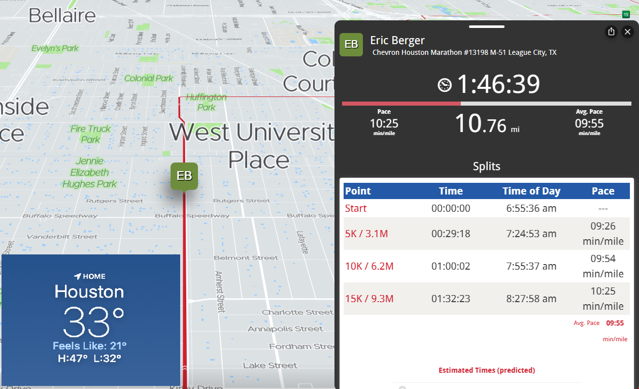
Before jumping into the post, I also want to thank the organizers of the Houston Marathon, as well as all of the thousands of volunteers and tens of thousands of spectators who make this such a special event. Yes, it was cold on the course on Sunday, but honestly after a mile or two the colder air felt great. It also feels great to be able to set aside my running shoes for awhile.

Monday

It is MLK Day, which honors the legacy of the civil rights leader Martin Luther King Jr. For kids, it’s a day off of school which, in addition to ‘snow’ days on Tuesday and Wednesday, makes for a five-day weekend. Not bad. It’s almost enough for me to wish I was seven years old again. Almost.

Anyway, today will be a brisk day with increasing clouds and high temperatures of around 40 degrees. A gusty easterly wind will add to the misery. We’ll see a slight chance of showers by around sunset this evening, but for the most part this should be rain in the Houston metro area. Please do plan to be wherever you’re sheltering from the storm this evening by about 8 pm for northern areas such as The Woodlands, and midnight at the absolute latest for central and southern parts of the Houston area.

Monday night and Tuesday

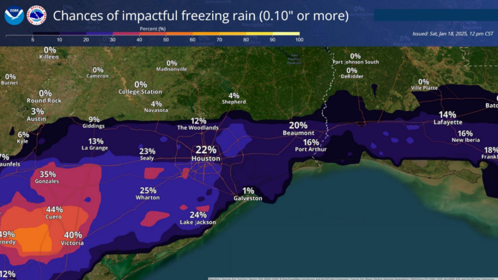
By around midnight temperatures in the region will reach freezing for most of Houston, and light rain will begin to transition to snow, sleet, and possibly freezing rain. The intensity of these snow showers or sleet will pick up on Tuesday morning. Low temperatures will drop to between 25 and 30 degrees for most of the region.

Most likely snow totals in the Houston area. (National Weather Service)

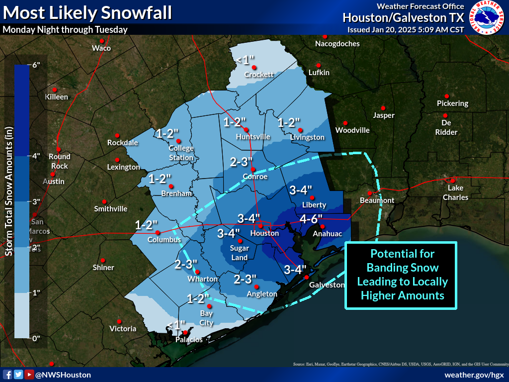
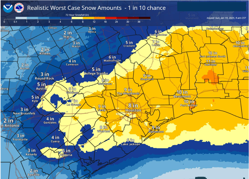
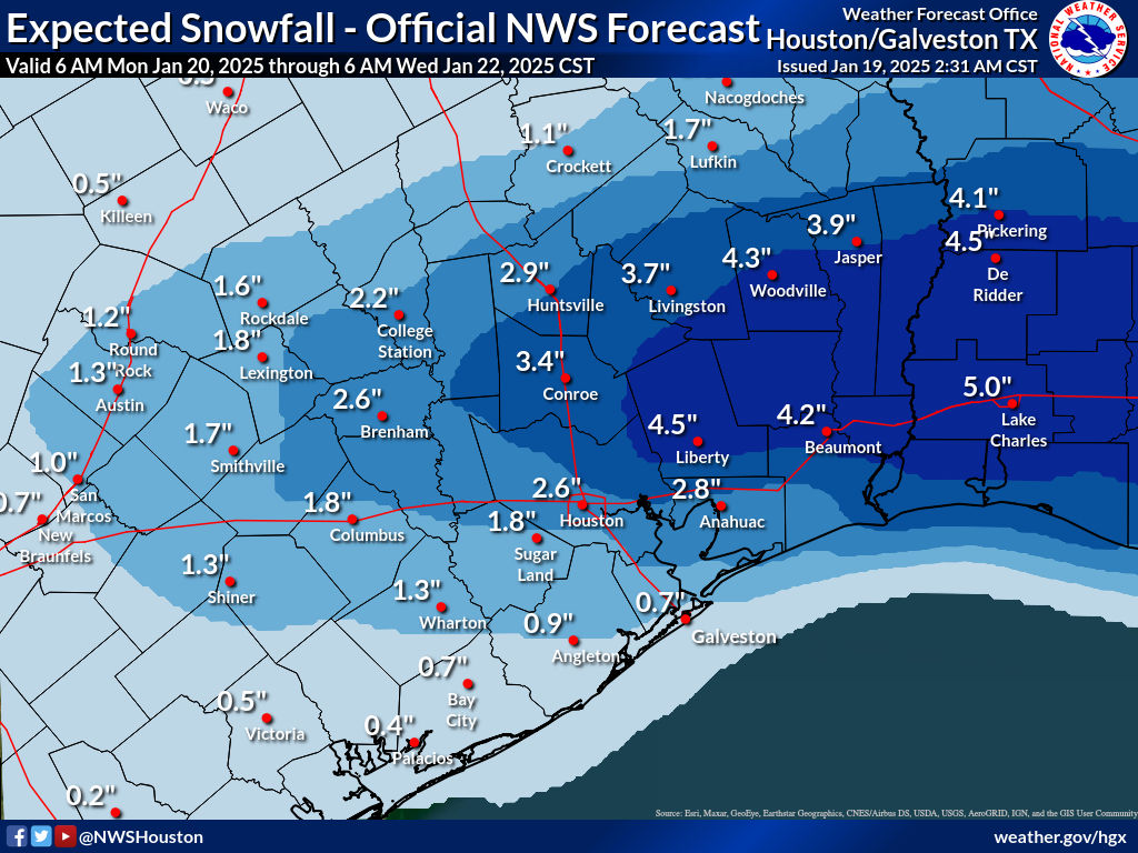
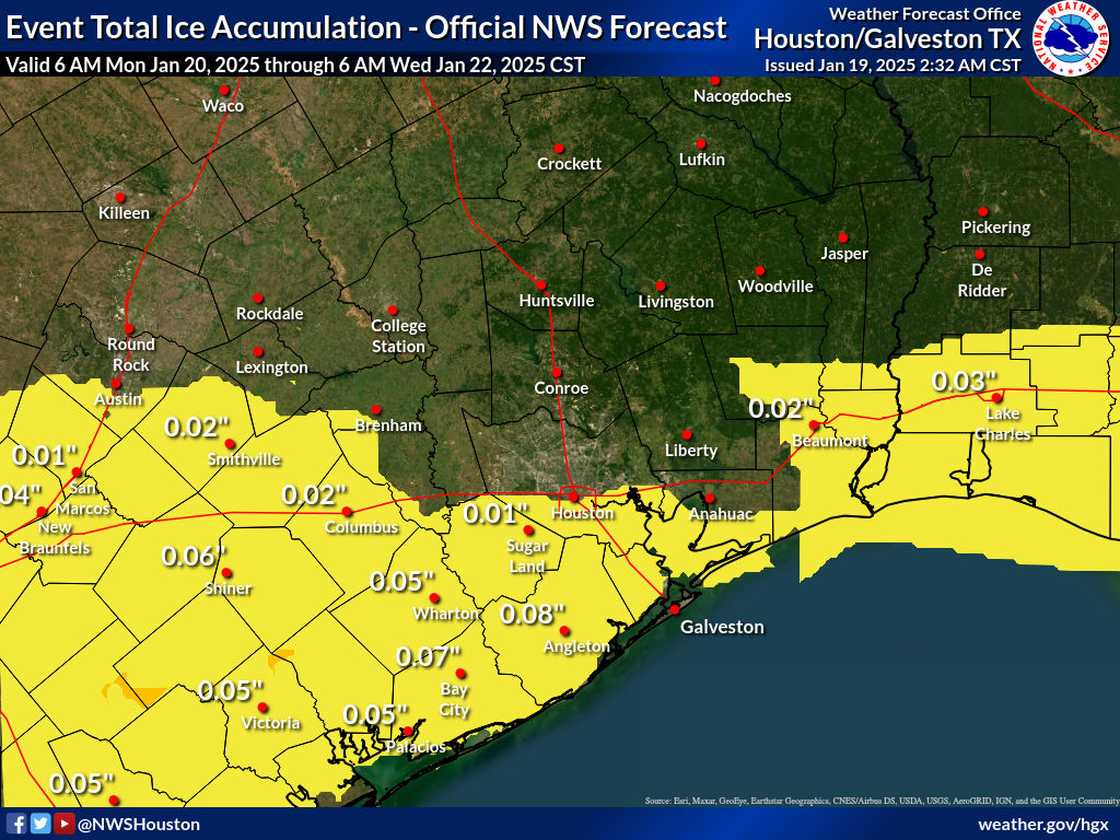
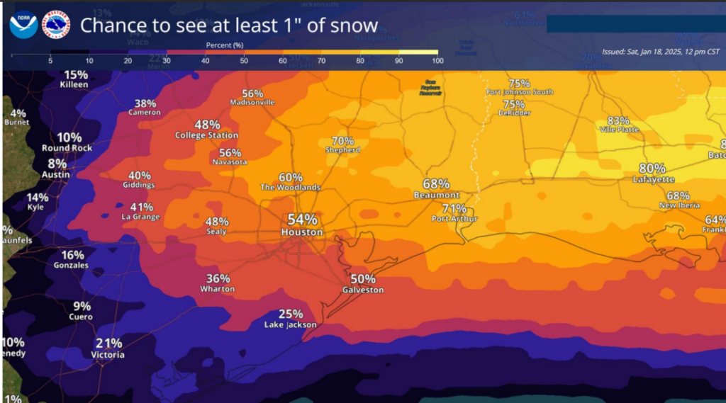
So what will you wake up to? I anticipate that most of the area will see 1 to 4 inches of snow, with some sleet mixed in by mid-morning on Tuesday. We still have some serious questions about the amount of precipitation, and I agree with Matt that there is a decent chance that some parts of Houston receive up to 4 to 6 inches. (Currently the favored region for this is probably along and south of Interstate 10, but we shall see). In any case, this should be wintry setup for which Houston-area roads are not prepared for.

Temperature wise, Tuesday is going to be interesting. The precipitation will end by around noon, and I expect we’ll see clearing skies during the afternoon hours. Temperatures will probably briefly get above freezing during the afternoon hours, and this may cause some of the snow and ice on the roads to briefly melt. However this window will be brief, as temperatures drop to below freezing by around sunset again. It will be a very cold night with slick streets.

Low temperature forecast for Wednesday morning. (Weather Bell)

Wednesday

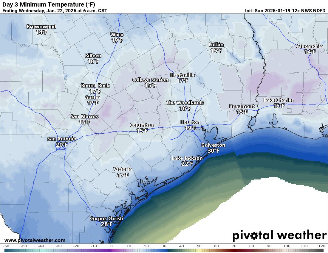
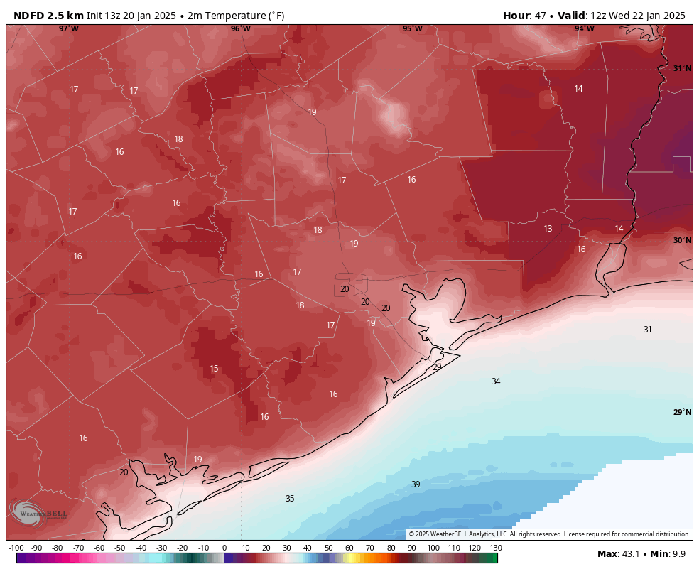
How cold will it get? That will depend on the extent of snow cover where you are. I think most of Houston will fall to around 15 to 25 degrees, so a hard freeze all around expect perhaps for the immediate coast, such as Galveston Island. Air temperatures will likely reach above freezing at some point on Wednesday around noon. Then, sunny skies and temperatures in the upper-30s, at least, should help to clear roadways during the afternoon hours. By this time it should be possible to resume somewhat normal activities around the region. But we’ll need to see how the mobility situation plays out.

Thursday and beyond

Lows on Wednesday night will drop into the mid-20s in Houston, so another cold night. However by Thursday afternoon we’ll be well into then 40s. A light freeze is possible again Thursday night. The weekend looks mild, with temperatures climbing back into the 60s. A chance of rain returns by around Sunday, or so.

Best sledding in Houston

It’s kind of insane, but we’ve reached the point where we can legitimately talk about sledding here. Now Houston is a pretty flat city, so there are not a lot of great hills. But there are a few, such as the hill at Miller Outdoor Theater in Hermann Park. However, when choosing a locale for sledding on Tuesday (and possibly Wednesday) it would be foolish to choose a spot you have to drive to. Since we’re not going to be driving around on Tuesday, are we? In reality the best place for you to sled in Houston the steepest hill you can walk to.

Which doesn’t lead down into a pond or a bayou.

Update schedule

We plan on having two additional updates today. One will come this afternoon, probably around 3 or 4 pm; and another later this evening when we should be able to provide real-time information on the developing winter storm.

A Winter Storm Warning is now in effect for the entire Houston area as we get closer to locking in a snowstorm

In brief: There have been few changes to the overall forecast today, with higher resolution modeling now coming into range on this storm and essentially validating most of what we’ve seen to this point. A legitimate, rare winter storm, with primarily snow and sleet is likely to impact most of the Houston area tomorrow night and Tuesday, causing significant travel disruption through at least Wednesday morning.

What’s new?

A few minor notes this afternoon, none of which are significant changes in thinking from this morning.

First off, the NWS has upgraded us to a Winter Storm Warning and increased their snow total forecasts for the Houston area.

The NWS is now forecasting about 4 inches of snow in Houston and Galveston, with higher amounts likely in spots. (NWS Houston)

They have also increased the “realistic worst case scenario” snow forecast.

The reasonable worst case scenario for snowfall totals from Tuesday’s storm. (NWS Houston)

Why has this happened? Well for one, modeling has continued to lock in colder with this storm, showing a sharp transition overnight Monday into Tuesday morning from plain rain, freezing rain, and a mix of sleet and snow to just sleet and probably mostly snow across the region. Secondly, high resolution weather models that only run about 48 to 60 hours out in time are now in range of the storm, confirming both that precipitation-type outcome and the potential for “banding” that will exacerbate local snowfall totals.

Again, we have to note: The snow will not fall perfectly uniformly across the region. Depending on where this “banding” sets up, that will determine places that are at risk for 6 inches or more of snow. Quite frankly, that could be anywhere in our area; we simply don’t know at this time. Recent model runs have favored the Houston through Liberty County areas, as well as Brazoria County through Beaumont areas, but that could easily change. I’d say we’ll know more tomorrow, but realistically, we may not know it until it starts.

Again, just to underscore: As long as the forecast stays on track, travel is going to be nearly impossible Monday after midnight and all day Tuesday. You will almost certainly be stuck where you are until at least later Wednesday morning. The exception to this may be the far north now (like north of Highway 105), where snow may end up lighter, no ice occurs, and roads may clear off a bit after the snow stops Tuesday afternoon. But even that may be optimistic. More to come on this.

Historical context

Realistically, this is the most significant snow threat to the region since Christmas Eve 2004. The 1895 storm stands alone as the greatest on record in Texas and Louisiana, and this storm will not dethrone that one. However, with that in mind, this has the potential to set a modern official snowfall record in Houston, which currently sits at a mere 3 inches back in February 1960. January 1940 also sits at 3 inches. While a few storms since then, including Christmas Eve 2004 have produced higher amounts in parts of the area, from a record-keeping perspective, we have a chance to make some noise.

Two-day maximum snowfall extremes in Texas by county; Chambers, Jefferson, and Fort Bend Counties in particular have a chance to set new records. (NOAA NCEI)

Could it be a blizzard?

This morning I noted how wind gusts of 40 to 50 mph were possible on Galveston Island Tuesday morning with this storm. That obviously begs the question of whether or not this could end up meeting blizzard criteria. That will be hard. The technical requirements are:

1.) Sustained wind or frequent gusts to 35 mph or higher. (This will be close)
2.) Heavy snowfall or blowing snow that reduces visibility under a quarter mile. (This will be tough)
3.) Three consecutive hours of these conditions. (This will be very tough)

I’m not saying it can’t happen, but given how rigorous these requirements are, I have doubts that we’ll officially get there. But at least now you know what an official blizzard is. That said, we almost certainly will see blizzard-like conditions on the island if those winds come to fruition and a full changeover from sleet to snow occurs.

Whatever the case, we are into some seriously rare winter weather for Houston in what may end up being a generational winter storm. We will have the latest for you in the morning with revised model data at our fingertips.

Could this actually be a legitimate snowstorm for the Houston area? It’s possible.

In brief: A major winter storm continues to look likely for the Houston area Monday night and Tuesday, with the potential for heavy snow and sleet in parts of the region. Minor ice may occur near the coast, along with windy conditions. Travel will become difficult to impossible Tuesday morning and remain that way through at least Wednesday morning across most of the area. A significant, damaging freeze is likely Wednesday morning as well. We do warm up Thursday.

Current cold

If you’ve stepped outside, or like Eric, started running the Chevron Houston Marathon, you know it’s, um, cold.

It is a cold morning across the Houston area. (NOAA)

Speaking of which, let’s check on Eric as of 8:40 am! Good luck to Eric the rest of the way!

Go Eric, go!

Temperatures will recover some today, getting up into the low or mid-40s. Another cold night is expected tonight, with lows in the 20s across most of the area away from the coast. Expect a hard freeze for many outlying areas and some areas in the city too.

Remember the basic preparations you should be taking.

  • PLANTS. Protect tropical vegetation. Please note, with temperatures dropping this low, some vegetation will probably die regardless.
  • PIPES. Protect any exposed outdoor pipes. Pipes in attics and along exterior walls of structures could freeze at these levels.
  • SPRINKLERS. Sprinkler systems should be shut off and properly drained.
  • ANIMALS. Prepare proper shelter and warmth for animals and livestock and make sure water sources are not frozen.

And also remember to check on people that may not have adequate insulation or access to heating.

Monday

Most of tomorrow should be fine. We will see increasing clouds that may hold temperatures back a bit. Highs should be in the upper-30s. Precipitation begins sometime either Monday afternoon or evening. With temperatures comfortably above freezing, whatever falls initially may be a light rain. Resist the urge to call bust.

Sidebar: The air mass over us will be quite dry. This is important. As the rain begins falling on Monday afternoon and evening, it may fall as virga (rain that does not reach the ground). But as it evaporates on the way down, it will cool the entirety of the atmosphere from a few thousand feet up to the ground. This is essentially priming us for snow and sleet. So initially, it may fall as rain, but that will change Monday night.

The best advice we initially can offer: Be where you need to be by early Monday evening and prepare to be stuck there through at least Wednesday morning.

Monday night and Tuesday morning winter storm

As the precip increases in coverage and intensity and temperatures drop, we will see a changeover from rain to a mix of sleet and snow. I have to be honest: Much of the model data seems to be favoring a gradual change from sleet to mostly snow, especially along and north of I-10. South of there, it should still be a mix of sleet and snow, with potentially a little freezing rain near the coast or Matagorda Bay area.

A couple notes about how things will unfold.

  • This storm has been strongly signaling what we call mesoscale banding or the potential for a deformation zone. In plain language? There will be widespread snow and sleet, but embedded within that will be a couple corridors of heavy snow. Those bands can see quick, heavy accumulation and snow rates of 1 to 2 inches per hour, along with the potential for thundersnow.
  • That banding will also lead to a disparity in snow totals. You could, in theory, have an area that sees 2 to 3 inches and literally down the road an area that gets 6 or 7 inches.
  • Sleet is the biggest risk to all this. If we end up with significant sleet and less snow, accumulations will be much lower — but travel will be just as bad. Models are trending toward more snow over sleet for much of the region, but admittedly, this is not an area where models handle things super wonderfully.
  • Wind will howl on Tuesday morning, especially on Galveston Island, where gusts could exceed 40 to 45 mph. Inland gusts will be to 20 to 30 mph. Coupled with areas of heavy snow, this will create extremely poor visibility and potentially some blowing and drifting of snow. Yes, that’s an actual sentence I just typed for Southeast Texas.

When all is said and done, how much snow will you get in your backyard? The official NWS forecast is shown below.

Official NWS snow forecast for the region. (NOAA)

I will say that the risk is probably asymmetrically skewed to the higher side here. In other words, there is a chance of more snow than shown, but again it will depend on sleet and exactly where those “mesoscale bands” setup. Max totals could be, could be as high as 6 to 8 inches. But those will likely be the exception, not the rule.

How about ice? Well, the official NWS forecast is one that isn’t overly bullish on ice, which is good news. Ice is where you can start to have more meaningful issues with infrastructure issues (trees, power lines, etc.). Ice of this amount would make conditions a little extra slippery but be unlikely to cause damage.

Official NWS ice accumulation forecast. (NOAA)

The highest ice totals are likely to be south of I-10 and in the Victoria Crossroads back toward south of San Antonio.

Travel concerns

There’s no real good way to get around this: We are inherently unprepared for a major snowstorm because, well, it rarely ever happens. Thus, you can expect that travel will be difficult to perhaps impossible on Tuesday, probably Wednesday morning, and maybe even Wednesday afternoon. We really cannot underscore this enough: Barring a dramatic forecast change, tou will probably not be able to get very far in a vehicle Tuesday or Wednesday morning. Your flight will probably be cancelled. Prepare to be stuck where you are after Monday evening.

Wednesday morning hard freeze

With ideal conditions for cold weather, including fresh snow on the ground, you can expect Wednesday morning to be very, very cold. While it won’t be super cold across the rest of Texas, locally here in Southeast Texas, we may rival one of our coldest mornings of the last few years.

Wednesday morning’s forecast low temperatures. (Pivotal Weather)

Expect lows in the teens virtually everywhere away from the coast. Areas that see minimal snow accumulation will also likely be milder. This will be a hard, damaging freeze and maximum cold weather precautions need to be taken.

Wednesday afternoon should see sunshine but with snow and a bitter cold start, we will likely only get into the mid-30s or so. Another hard freeze is possible Wednesday night, albeit much less cold than Wednesday morning. And we should bounce back into the 40s on Thursday. Alas, the snow will melt.

Anyway, we’ll update you on any changes later this afternoon. But hopefully this post answers most of your questions in the meantime. Stay warm!

Saturday afternoon update: Snow, sleet, and freezing rain still in the mix. And will the power hold?

In brief: It is the final hours before the Arctic freeze sets in, and we’ve got the latest information on what to expect in terms of cold and wintry precipitation, and when to expect it. The bottom line is that Tuesday and possibly Wednesday both look very iffy for traveling around Houston.

It could be worse

As I type this, the Houston Texans are kicking off against the Kansas City Chiefs in the Divisional round of the NFL Playoffs. Game-time temperatures are in the low 20s, with gusty northwesterly winds. By Tuesday morning the low temperature there is expected to be -1 degree Fahrenheit. So yes, Houston is going to get cold this coming week, but it could always be worse. Also, let’s go Texans!

Temperatures in Texas this afternoon range from 20 degrees in the Panhandle to 80 degrees in the Valley. But the cold is coming for us all. (Weather Bell)

Temperatures will soon begin falling

It’s fairly pleasant outside, with temperatures in the low 60s across much of the Houston region. But don’t be fooled. Winds are steady from the northwest, and as the Sun falls toward the horizon, temperatures will follow. Lows tonight will drop to around freezing in Houston, and with gusty northerly winds the apparent temperature will feel as if it is in the low 20s, at least tomorrow morning. So if you’re joining me at the Houston Marathon, bundle up, wear layers, and use the cold as motivation to go faster. Despite the cold start, Sunday will be fine in terms of getting out and about. Highs will reach the low- to- mid-40s with sunny skies.

Forecast for wind gusts at 6 am CT on Sunday morning. (Weather Bell)

MLK Day

Houston will likely see a light freeze on Monday morning, although some inland areas (i.e. along and north of Highway 105) could see lows drop into the mid- to upper-20s. But Monday should be mostly fine for any last minute preparations ahead of a winter storm. Highs will be around 40 degrees. I’m afraid it’s a dreary forecast for MLK Day festivities, with increasing clouds and gusty easterly winds keeping a distinct chill in the air.

Monday night through Wednesday morning

You should plan to be home by around 9 pm CT or so on Monday. Although temperatures probably won’t fall below freezing until a few hours later, we might start to see some light sleet or snow by around this time. Temperatures reach freezing levels by midnight or so, when precipitation coverage should also begin to increase.

This is the point of the forecast where we are still mired in uncertainty. The key questions are a) how much moisture will be available for precipitation to form and fall, and b) what kind of wintry mix will develop. Neither is answerable yet. For areas along and north of Interstate 10, I continue to think snow is the most likely option (perhaps 1-3 inches, or more), but we could see sleet mixed in. For areas south of Interstate 10, sleet may be more likely than snow, although we may still see some snow there. Further to the southwest, in Matagorda and Brazoria counties, we may see freezing rain as the dominant precipitation.

Probability of seeing at least 1 inch of snow through Tuesday. (Weather Bell)

The bottom line is that when you wake up on Tuesday, some sort of winter wonderland (or nightmare) is going to exist outside. Snow/sleet/freezing rain is likely to continue through the morning hours on Tuesday, and possibly into the early afternoon. We may see some partially clearing skies by evening. However, temperatures will struggle to reach above freezing on Tuesday, and if they do in Houston it may only be for an hour or two. So I don’t think we’re going to get enough warmth to melt and clear streets.

Depending on how much snow cover there is overnight, temperatures in Houston will either be in the upper teens or lower 20s on Wednesday morning, which will be the coldest of the week. Virtually the entire metro area, aside from the coast, is likely to experience a hard freeze. This is going to help maintain ice or snow on area roads, and my sense is that Wednesday morning will likely once again be a no-go for traveling around the area.

Odds of seeing impactful freezing rain through Tuesday. (Weather Bell)

By Wednesday afternoon, the combination of (slightly) above freezing temperatures and sunny skies will probably help clear roads. But it’s difficult to be certain of this right now.

The end

Highs finally get back into the mid- to upper-40s on Thursday, so at this time we think Houston will return to normal by that time. Next weekend looks to be fairly mild.

Will my power go out

Honestly, we can’t answer that. However, our supposition is that things probably will be OK in Houston in terms of electricity. ERCOT issued an update on Friday saying that while it is monitoring grid conditions closely, they are expected to remain “normal” during the upcoming winter weather. That means officials are fairly confident the grid will hold up during the colder weather. Additionally, Houston is not expected to get significant accumulations of freezing rain, which can build up on power lines and snap them. So, cautiously, we’re optimistic. But we will see.

Next update

Since I’m running the marathon tomorrow and will be cooked for the rest of the day, Matt will be covering on Sunday. We’ll have a morning and late afternoon update on the winter storm situation, similar to today.