It will be rather warm this week, but spring is not yet over in Houston

In brief: March has been fairly warm, and this coming week will bring us some of our hottest weather of the year so far. But that does not necessarily mean spring is over. In fact, next week looks to be quite a bit cooler with the possibility of lows in the 40s for a few mornings.

It’s still spring, right?

March is drawing to a close today, and by the calendar we are supposed to have two more months of spring. However, this March has been rather warm, running more than 4 degrees above normal. Moreover, this week will see several days with temperatures in the upper 80s to 90 degrees. It might almost feel like summer is at hand. However, we have fairly high confidence in the arrival of a robust front this coming weekend, which will bring temperatures back into line for spring.

Monday

It is rather sticky outside this morning, with temperatures in the low- to mid-70s and dewpoints nearly as high. A very weak front is on our doorstep, and it will slowly sink into the region today, knocking down humidity slightly. Look for high temperatures in the low- to mid-80s with mostly sunny skies. Temperatures tonight will drop into the mid-60s for most of the metro area.

Temperatures will be warm this week, with Thursday possibly being the hottest. (Weather Bell)

Tuesday

Some fog will be possible Tuesday morning, and as it lifts we should see mostly cloudy skies. This should help limit highs in the lower 80s. The front won’t last long, as we’ll see winds picking up from the east, and then the south later on Tuesday. They may get fairly gusty, up to 25 mph. Lows on Tuesday night will drop only into the lower 70s for most locations.

Wednesday, Thursday, Friday

These should be fairly similar, fairly warm days. Each day should bring partly sunny skies, and warm temperatures. Highs will vary from the upper 80s to about 90 degrees for most locations. We’ll also see gusty afternoons, perhaps peaking at 30 mph for a few hours. Nights will be quite warm, dropping only to about 75 degrees.

NOAA rain accumulation forecast for this weekend. (Weather Bell)

Saturday and Sunday

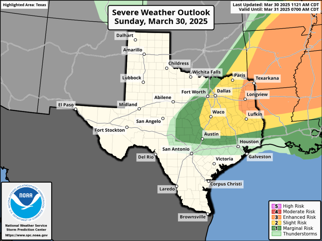
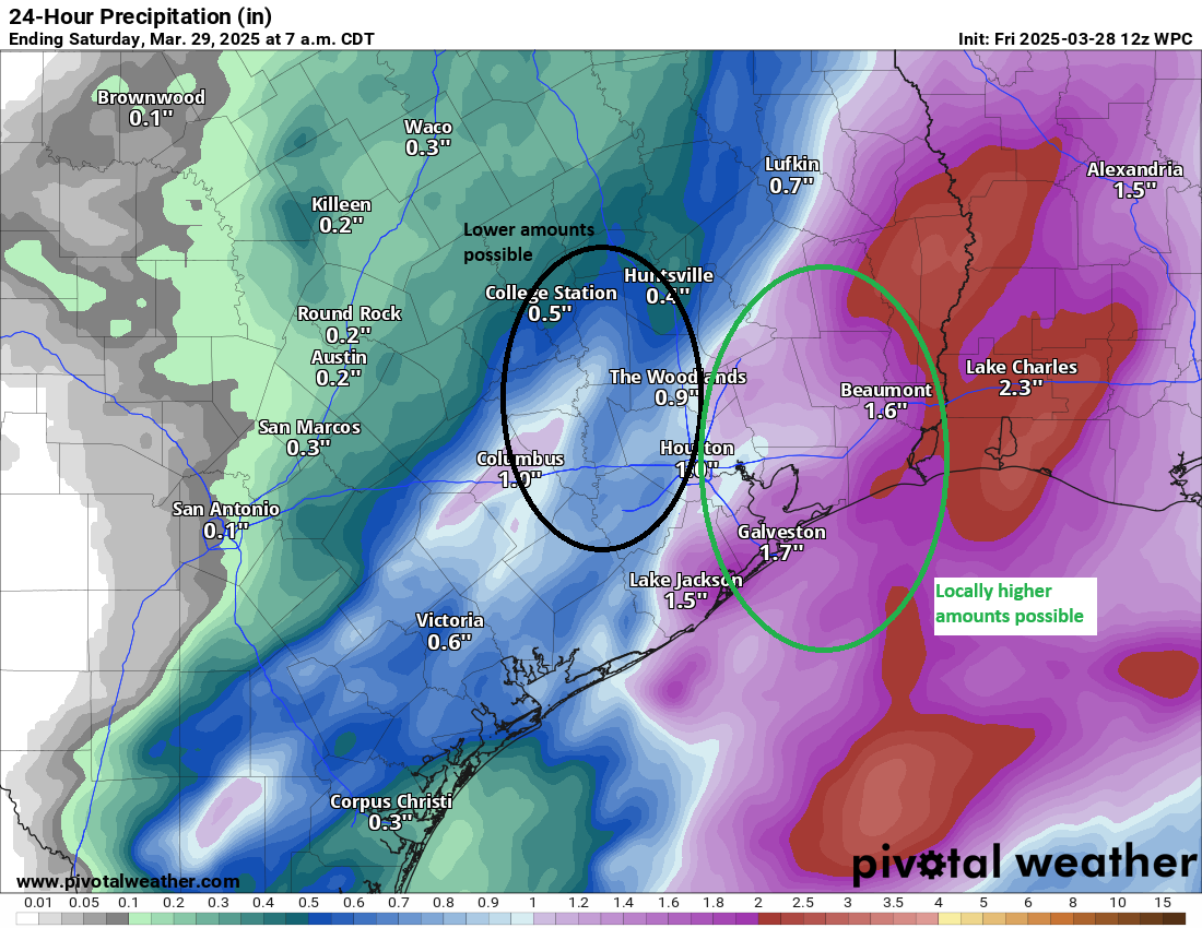
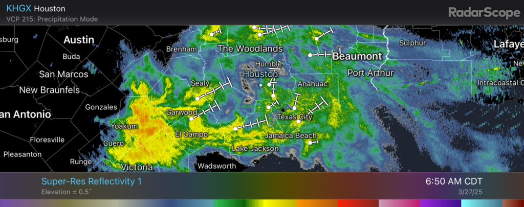
The weather for this coming weekend is somewhat unsettled. Saturday looks to be mostly cloudy, with highs in the mid-80s, as an upper-level low pressure system brings elevated chances of rain into the region. At some point on Saturday or Saturday night, most likely, a stronger front will push through the region. Lows on Saturday night may drop down to around 60 degrees, depending on the timing of the front, and some showers may well linger into Sunday morning. Highs on Sunday should top out in the vicinity of 70 degrees, or so. If you have outdoor plans for Saturday and Sunday, showers and thunderstorms are a concern, but not a certainty. We’ll fine tune things as the weekend gets closer.

Next week

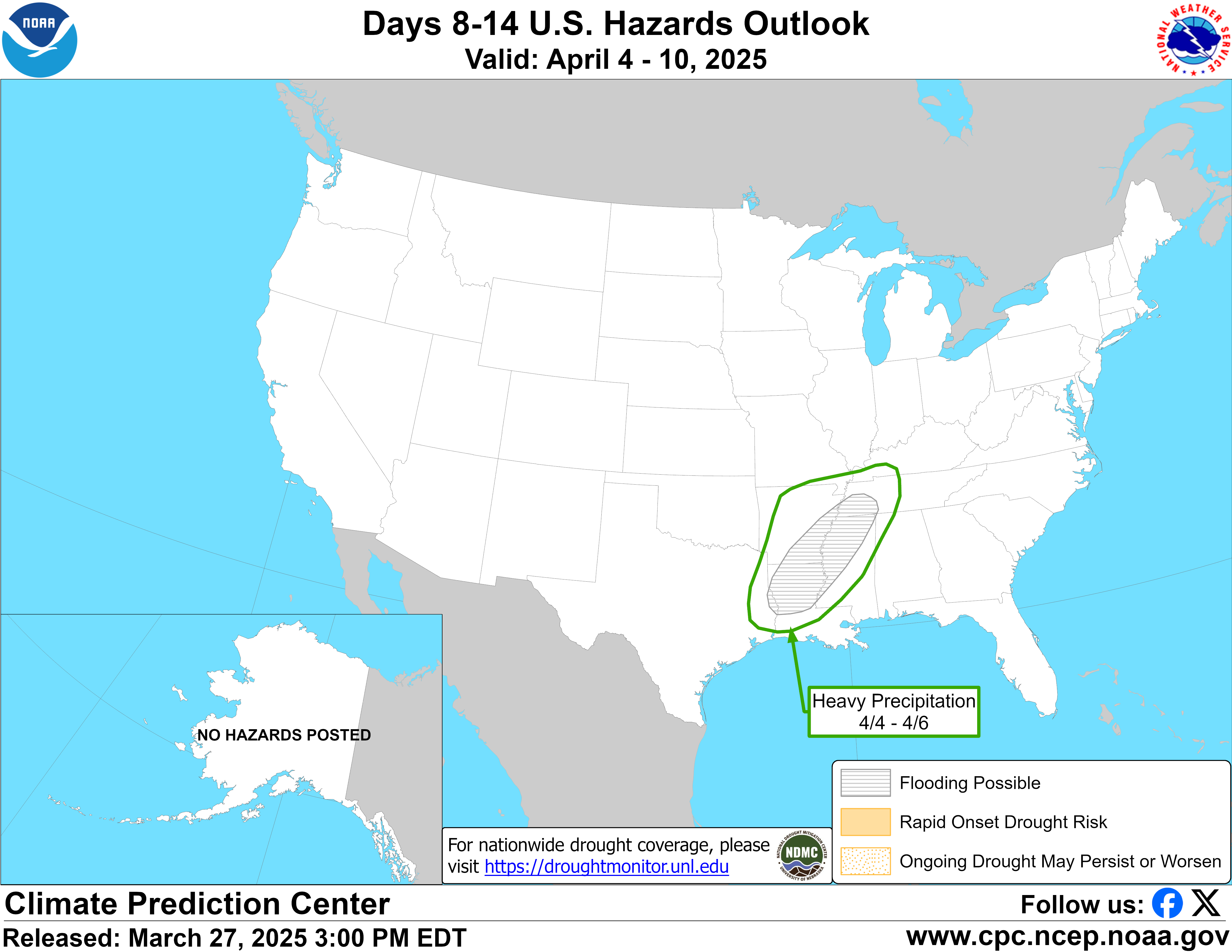
Houston will face a nice slug of cooler weather next week. Although it’s impossible to be too precise this far out, I’m thinking days with highs of around 70 degrees and lows in the 40s or 50s. So yeah, it will be nice to have a chill in the air again for a few days. The cooler weather should hang around for most of the week.

Strong thunderstorms are possible in the Houston metro area this afternoon

In brief: We’re interrupting your Sunday with a short post to note the possibility of severe weather in the Houston metro this afternoon and early evening. Conditions aren’t ideal, but they could support strong thunderstorms.

Hi everyone. I hope you’re enjoying this humid Sunday in our fair city. We’re posting a quick update to note the possibility that some strong thunderstorms may develop this afternoon in association with a weak front approaching the region. Unfortunately we don’t have great data about the state of the atmosphere—a sounding over the city or just to our northwest would go along way—but there are some ingredients available for the development of storms.

The most likely timeframe will be from about noon to 8 pm CT. If the capping inversion in the atmosphere (preventing warm, humid air at the surface from rising) ends up breaking over the city, we could see a fairly wide outbreak of thunderstorms. There will be the usual threats in the form of hail, damaging winds, and possibly a tornado or two. I want to emphasize that conditions are not ideal for severe weather, but the potential is lurking in our atmosphere.

The bottom line is that if you’re going to be out and about this afternoon you will want to check the radar and be prepared for inclement weather. The likelihood of storms will diminish this evening, and then should fade entirely tonight in Houston. We’ll be back with a comprehensive update, as usual, on Monday morning.

One more day of rain chances before a mostly quiet weekend in Houston

In brief: Scattered showers and storms will pop up in the Houston area through the day today, leading to locally heavy rain, especially east of I-45. A couple stronger storms cannot be ruled out either, again especially to the east. After a quieter period this weekend and early next week, we may be in store for more unsettled weather and rain chances late next week and weekend.

Rainfall update

Of note in Texas, there was some truly awful flooding late yesterday and last night in the Rio Grande Valley. Harlingen had nearly 14 inches of rain yesterday with over 10″ falling between 5 and 11 PM last night. It was their wettest day on record, with all but one other top 25 wettest day occurring between May and November prior to yesterday. For McAllen, it was the third wettest day on record. Even Brownsville cracked their top 25 list as well.

Radar estimated and gauge corrected rainfall the last couple days in South Texas, with much of the Lower Rio Grande Valley seeing 8 to 15 inches. (NOAA MRMS)

Locally, we have not seen that kind of rain. Fulshear and Simonton saw some locally heavy rain, with 1 to 3 inches falling there, extending north into Waller County. And areas southwest of Wharton and around Matagorda Bay saw 1 to 4 inches. Harris County saw rain yesterday, but most areas saw a half-inch or less.

Radar this morning shows some heavier showers in Liberty County but mostly calm conditions elsewhere. As the day drags on, look for additional showers and embedded thunderstorms to crop up. I would not be at all surprised to see some very hefty downpours occur, particularly along or east of I-45 later this afternoon. We are in a marginal risk (1/5) for severe storms, so any storm that we see today could produce some gusty winds or even a brief, isolated tornado, particularly between Winnie and Lake Charles later today. However, I don’t want to discount the Houston area, as we have not exactly had great model performance with geographic placement of storms this week.

Forecast rainfall today from the NWS, though I would lean lower to the west and near-forecast with isolated higher amounts to the east. (Pivotal Weather)

Rain totals are a bit tricky to nail down, but I would say, expect around a half-inch in Houston with a few higher amounts possible east of I-45, lesser amounts to the west. To the east, we should see 1 to 3 inches, with even some higher amounts possible in spots. We will keep our stage 1 flood alert in place. Rain rates yesterday were easily near 3 inches an hour in the Valley, and that could be noted here as well.

So, bottom line: Scattered showers and storms today. Especially this afternoon. Locally heavy downpours, especially east of I-45, along with a low-end severe weather risk. Localized street flooding remains a concern in those areas with heavier, more persistent rain.

Saturday

I’m going to spin tomorrow optimistically. I think we’ll start off cloudy, perhaps with some areas of fog. There may even be a few light showers around. But as the day progresses, I suspect we’ll see improvement, with more sunshine, less cloud cover, and high temperatures popping back into the 80s. We should hopefully be able to keep the Houston Open moving along.

Sunday

While the majority of Sunday looks fine in the Houston area, there will be a passing disturbance to our north. As this occurs, it could be enough to set off some thunderstorms, primarily north of I-10 and especially north of Highway 105 across Navasota, Conroe, and Cleveland. South of I-10, storms will be unlikely. The most likely time for a few storms would be in the late afternoon hours, heading into the early evening. Everything quickly clears to our east by mid to late-evening. We’ll warm from the upper-60s into the low-80s.

Early next week

We should get a weak front through here Sunday night or Monday morning that ushers in some notably more comfortable air for a day or so. Thereafter, the onshore machine will pump back warm, humid air off the Gulf and into Texas by Tuesday afternoon or Wednesday. Low temps should remain in the 60s with highs in the 80s most of the time. Daytime highs could push upper-80s by Wednesday.

Later next week

A more unsettled pattern looks to settle in over Texas and more broadly the Plains and Southeast later next week, which could linger through the weekend. I don’t expect a ton of rain here right now, but I do believe our thunderstorm chances will increase. This may be especially true as you get north of Houston and northeast into Louisiana and elsewhere.

The 8 to 14 day hazards outlook from the Climate Prediction Center is highlighting areas just northeast of Houston next week for heavy rainfall. (NOAA)

That said, it’s too soon to say much more than that. As we noted in our Q&A post the other day, sometimes there is enough signal in the model noise to highlight a forecast risk, and in this case that’s what we have late next week and weekend. Stay tuned!

Upper-level system should bring mostly manageable rain into the region today and Friday

In brief: Light to moderate showers are moving into Houston from the southwest this morning, and this more or less will be the pattern over the next two days. There’s a chance for some heavier rain on Friday afternoon or evening, but overall the threat for significant flooding in Houston and surrounding suburbs is fairly low. After Friday, our weather turns warmer for awhile.

Rain status

For a few days now we’ve been discussing the impending arrival of a disturbance in the upper atmosphere, and its potential to drop buckets of rainfall over the region. There has been a see-saw battle between global and regional weather models. Now that the rains have finally begun, the contours of this system and its impacts are finally coming into focus. Essentially, instead of seeing mostly heavy rainfall in the Houston region, we are likely to see mostly light to moderate showers over the next two days.

Regional radar as of 6:50 am CT on Thursday morning. (RadarScope)

The one exception to this is locations southwest of the Houston metro area, including Jackson, Matagorda,
Wharton, and Colorado counties that have already received 1 inch of rainfall. Some locations within these counties may eventually pick up 4 to 6 inches of rainfall with higher totals. This is certainly enough to cause some street flooding issues. So areas southwest of Houston could get soggy. But as for Houston itself, we are probably looking at rain accumulations of 0.5 to 2 inches between now and Friday night.

I am going to leave the Stage 1 flood alert in place for areas south of Interstate 10 out of an abundance of caution, because at this time there should not be significant flooding or mobility disruptions in Houston and its suburbs.

Thursday

We are seeing light to moderate showers moving in from the southwest this morning, and these should be fairly persistent for much of the day. Expect on-and-off rain, with overall mostly light accumulations. Certainly there could be a few isolated thunderstorms with some heavier rain, but I don’t expect widespread issues. With cloudy skies, high temperatures today are likely to peak in the mid-70s with easterly winds of about 10 mph and higher gusts. There may be a lull in the rain this evening (or not) before more widespread showers return after midnight.

The potential for heavy rainfall is greater to the southwest of Houston this week. (Weather Bell)

Friday

I expect Friday to be similar. If there is a time when we may see more dynamic weather, including heavier rain, it probably will come on Friday afternoon or during the early evening hours. I don’t have great confidence yet, but it’s possible that some sort of line of storms will push through the area from west to east during the evening commute, and disrupt the start to the weekend. We’ll keep an eye on that. Some rain chances will linger Friday night but generally, by Saturday morning, the upper-level system will have moved on.

Saturday and Sunday

The weekend should see partly sunny and warmer skies. Look for highs in the mid-80s on both days, and sultry springtime lows only dropping to around 70 degrees. With dewpoints in the upper 60s, it will definitely feel pretty humid after winter in Houston. It’s good for the skin, I guess.

Next week

Most of next week should see additional warm and humid weather with highs generally in the mid- to upper-80s and warm nights. We may briefly see some drier air on Monday night and Tuesday with a weak front, but it will not be much to write home about. Some kind of front may push through next weekend to bring cooler weather by Sunday or Monday, but since that’s 10 days out our overall confidence is fairly low.