Texas drought expands as Houston eyes at least a chance of rain Sunday

In brief: Drought continues to expand in Texas, and pollen levels are roofing in Houston with warm, dry weather. There are some rain and storm chances for Sunday night or early Monday and again next week, but those are far from certain. Warmer weather returns and lingers.

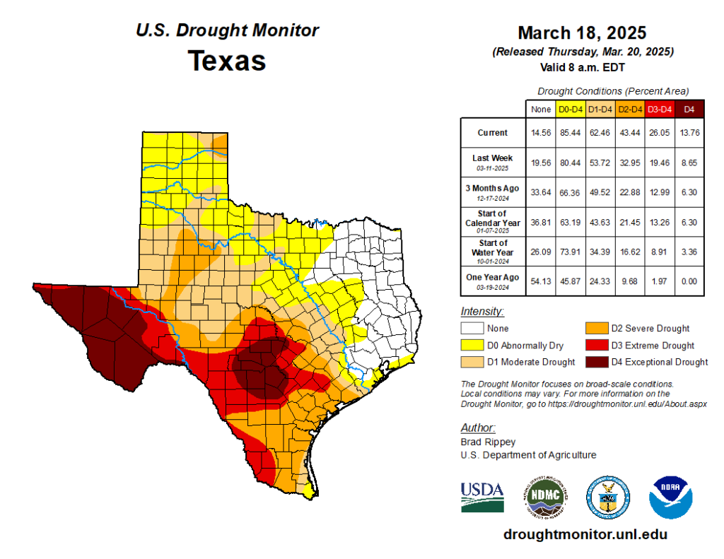
We got the drought map update yesterday for the country, and as you can see below, drought is expanding in Texas. While the majority of the Houston area is not there yet officially, it doesn’t take much to tell we need some rain around these parts.

Drought covers over 60 percent of Texas today, up from 54 percent last week. (US Drought Monitor)

While West Texas and Hill Country are in exceptionally bad drought, we’ve got problems of our own locally, as evidenced by the Pauline Road Fire north of Houston on Wednesday and Thursday. This fire was apparently started as a result of a prescribed burn, and it expanded rapidly due to 20 to 30 mph winds and low humidity, along with increasingly dry ground. The type of fire conditions in Texas that are currently in place have not really been seen since 2011. So, again, we need rain.

The pollen, as Eric noted yesterday is another matter. Our tree pollen count in Houston hit over 9,000 yesterday for the first time since the brutal April of 2022, when we exceeded 12,000 on April 7th. Yesterday, should it be our peak pollen day, will be right around average but the second highest since 2017.
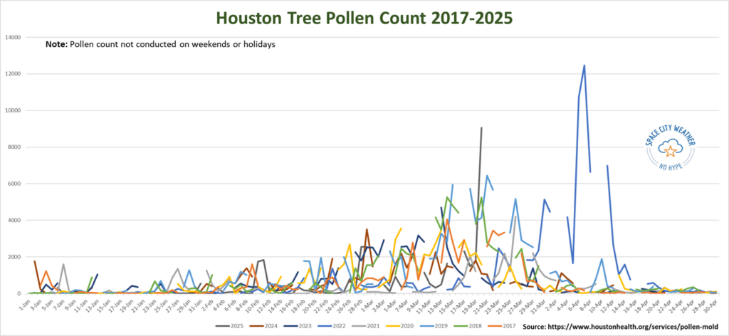
Daily chart of City of Houston pollen measurements back to 2017 (Jan 1-Apr 30), with gaps in the data due to weekends and holidays. Click to enlarge.

You can see the large jump yesterday in 2025’s data on the chart above. Historically, Houston’s tree pollen will have a handful of big days, then slowly tail off. Notice how 2022, while the worst in the data set also peaked quite late. If history is a guide, the oak pollen levels mostly responsible for this data spike should slowly (emphasis on slowly) subside in the next few weeks. But suffice to say, it will be bad at times over the next couple weeks for those with seasonal allergies. That especially holds true if we don’t get any rain this weekend.

Today and tomorrow

Winds will turn around eventually today and start coming out of the south. This will raise our humidity levels and keep us outside of red flag conditions. After a very cool start this morning, we will warm into the 70s this afternoon. A picture-perfect day.

If you’re headed to the final Friday of the Houston Livestock Show & Rodeo to get a listen to Parker McCollum tonight, expect clear skies with a slight breeze on the way in. Temperatures should be around 70 degrees, slipping back into the mid-60s by the time you head back home.

Overnight lows will be about 10 degrees warmer tonight than they were this morning. That warmer start will allow Saturday to pop into the 80s. Look for a mix of sun and clouds with no weather woes.

Sunday

Most of Sunday will be fine. Expect clouds and some sun, along with warm weather. Highs should get into middle 80s on Sunday afternoon. As a disturbance drops southward during the day, we could see one or two thunderstorms pop up across the area very late Sunday afternoon, probably after 3 or 4 PM. Any of those storms could be on the stronger side.
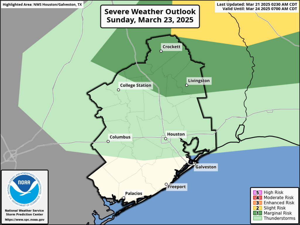
Our outlook for severe weather on Sunday is not too foreboding with risks mainly to our north. (NOAA SPC)

That said, we are not currently in a severe weather risk highlight, just a “general thunderstorm” area. However, this is the type of setup where if one storm can find the right environment it could make some noise. In other words: We’re probably fine on Sunday, but there could be a storm that gets a little noisy.

There could be some strong to severe storms well north of the Houston area that form into a weakening line of thunderstorms Sunday night, arriving in the Houston or perhaps Beaumont areas late Sunday night or early Monday morning. There should not be severe weather along this front, but some lightning, heavy rain, and gusty winds are possible as this moves into the area.

Monday

Any showers or storms should push offshore Monday morning, and we’ll be left with gradual clearing. Expect highs to jump back into the upper-70s or low-80s.

Rest of next week

Tuesday looks quiet right now. Wednesday may see another chance at some showers or thunderstorms, but it’s a bit soon to offer up more than just a low chance. We could see more widespread rain chances by Thursday.

In terms of additional fire weather, humidity levels look to stay high enough to avoid much more serious concerns next week. But the rain we see (or don’t see) may play a role in ultimately determining that. Monday or Tuesday will probably have the lowest humidity for the week. Temperatures will likely be a bit above 80 degrees, with morning lows in the 60s.

Odds and ends about springtime in Houston as we cruise through the equinox

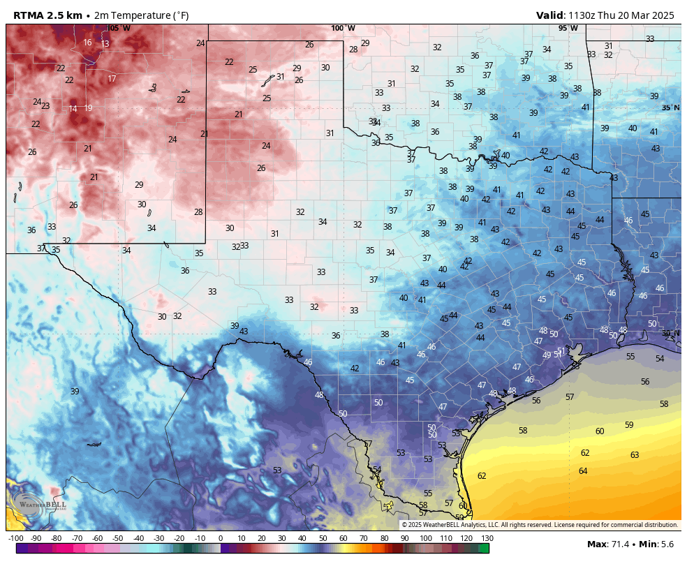
In brief: We’re experiencing a chilly morning, and we have one more cold night before we enter a generally warmer pattern. In addition to a mostly spring-like forecast, today’s post includes some musings on the passage of winter, into spring, into summer in Houston.

It’s a cold morning across much of Texas. (Weather Bell)

Thoughts on spring

Last night, a little after 10 pm, I let the dogs out for the final time before bed. As I stood in the dark, enjoying the quietude, I heard it. That characteristic zing of a June bug kamikazeing into the back door. It was the first of the season here, the first of what surely will be thousands over the coming weeks. In Houston, June bugs come in March. It is the way of things, the rite of passage from winter to spring to finally summer.

You can see it in the trees as well. Only a few days ago, leaves were still falling from the trees in my backyard. Now, it is pollen. There is so much pollen. It is the price we pay for shade in the summertime, and a price I will gladly pay. But do you know what did not fall from the tress this year? Acorns. By my fallible memory, we have had two mast years within the last half decade, when the acorns dropped from the trees for weeks on end, carpeting lawns and creating seas of seeds. There seemed to be billions of them. This year, I think I saw maybe one or two. Should we worry about the squirrels?

It is a time to think about such things. Planet Earth spun through the spring equinox this morning at 4:01 am local time. It’s OK, I didn’t wake up for it either. It just means the Sun is directly over the equator today, and that its light is shining equally on both the northern and southern hemisphere of the planet. Although by some definitions the spring equinox marks the beginning of spring, in our area spring more typically runs from late February into the middle of May.

After that, of course, comes summer. But on such a pleasantly crisp morning as we have today, there is no need to think about that quite yet.

Thursday

Temperatures have fallen to about 50 degrees, or a tad cooler, this morning under the influence of cool and dry northerly winds. Dewpoints are exceptionally low. Because of this, and ongoing winds of 10 to 15 mph, and higher gusts, the region will fall under a ‘red flag’ warning this afternoon from 1 to 7 pm. This means that wildfires could spread quickly. Highs this afternoon will reach the upper 60s for most locations under perfectly clear skies.

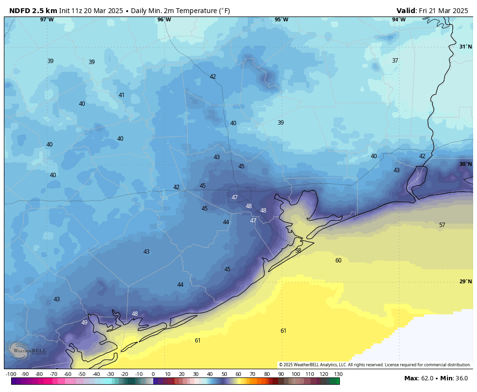
Winds will be subsiding later this afternoon, and early evening, if you’re headed out to the Houston rodeo. Temperatures will be in the mid-60s before the show, falling to the upper 50s afterward. So, slightly chilly. Low temperatures tonight will fall into the 40s for much of the Houston metro area. This may be the final night in the 40s for many locations this season, but there’s enough spring left in the calendar where I would not want to say that definitively.

Low temperature forecast for Friday morning. (Weather Bell)

Friday

This will be another sunny day, but temperatures will be warmer, in the mid-70s. We’ll also see those northerly winds swing around to come from the south, perhaps gusting up to 20 mph or so during the afternoon hours. As a result, lows on Friday night will only drop into the upper 50s.

Saturday

The first half of the weekend has no weather concerns, aside from some southerly winds gusting up to 20 mph or so. We’re going to see highs of around 80 degrees, with mostly sunny skies. With a warmer flow in place, lows on Saturday night will only drop into the mid-60s.

Sunday

Clouds should start to build on Saturday evening or night in response to increasing moisture levels in the atmosphere. Sunday looks to be a warmer, more humid day in the 80s. The region will see the potential for some light showers during the afternoon ahead of an advancing cold front. It’s a weak front, but it still could spark some scattered thunderstorms on Sunday night. Overall rain accumulations look fairly low for most locations, on the order of a tenth of an inch of rain, or two.

Next week

Monday is likely to be cooler as a modest amount of drier air filters in from the northeast. Let’s call it mid-70s, with the possibility of nighttime temperatures in the 50s. Most of the rest of next week should see highs in the 80s with lows in the 60s. There is a decent signal for rain showers from Wednesday night through Friday. An inch or so of rain sure would help us out, but it’s too far out to have absolute confidence in any such forecast. We’ll see.

Sharply drier air moves in behind a front today, but our weather turns warmer next week

In brief: A robust front will bring much drier air into the Houston region today, and a couple of chilly nights in the upper 40s. After that Houston will likely experience warmer weather for the rest of March: think 80s with some humidity rather than the 70s we’ve had for much of the month. Summer is not here, but it is on the horizon.

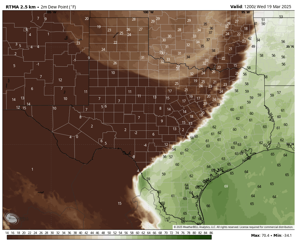
It is not difficult to find the cold front as of 7 am CT on this map of dewpoint temperatures. (Weather Bell)

Wednesday

Temperatures across much of the metro area this morning are in the range of 65 to 70 degrees, which is rather warm for mid-March. It’s also fairly sticky outside. However, this will end later this morning, as a fairly strong front moves into the area. We’ll feel this both in the form of northwesterly winds, gusting up to 20 or 25 mph, as well as much drier air. As skies clear out later today, with the drier air, expect high temperatures in the vicinity of 80 degrees.

Unfortunately for rodeo-goers, those winds will not let up much this evening. In fact, they should peak during the overnight hours, perhaps gusting up to about 30 mph. So be prepared for that. Temperatures after the show will be in the 60s, before lows tonight ultimately drop into the mid- to upper 40s for much of the metro area away from the coast.

Thursday

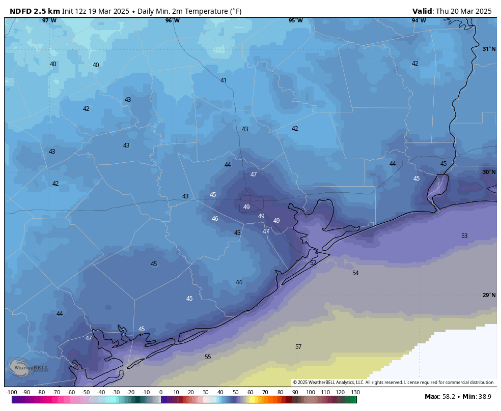
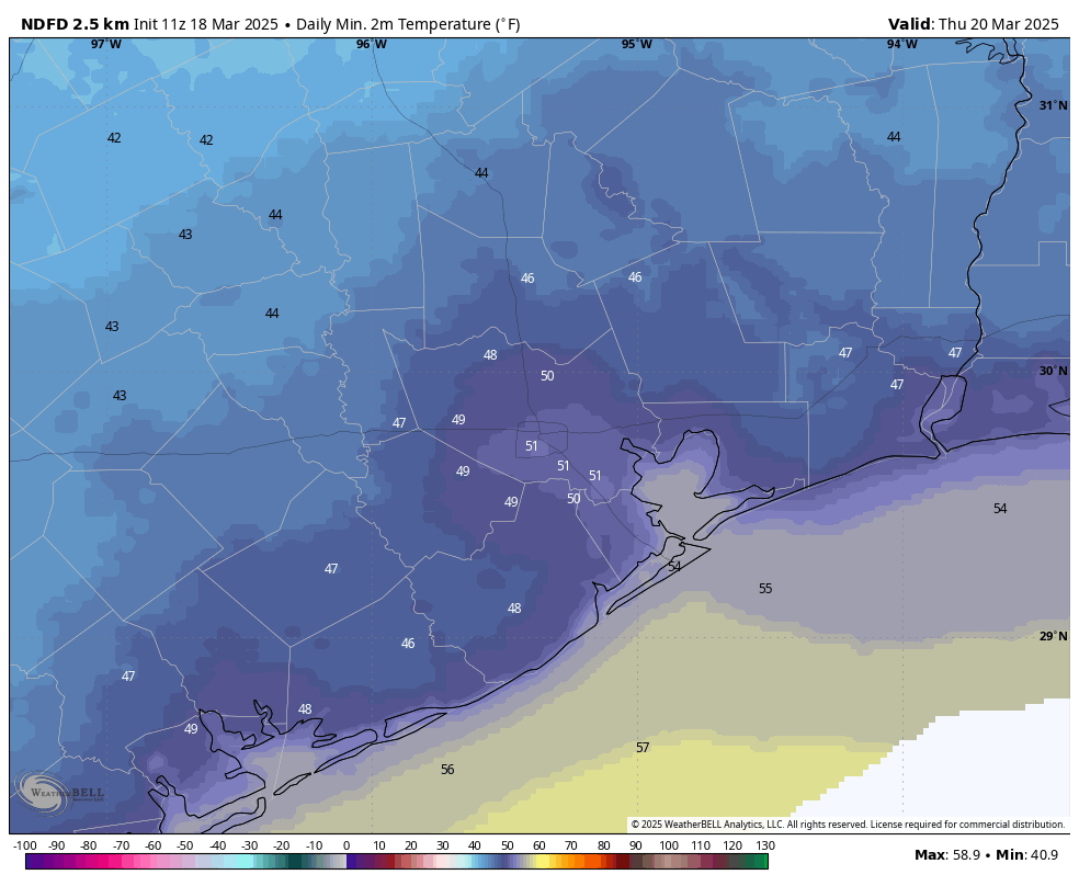
This will be a sunny and pleasant day, with low humidity and highs of around 70 degrees. During the morning hours, at least, we should still see some modestly gusty winds. However by the afternoon these winds will likely slacken. Thursday night will be chilly again, with much of the region likely dropping into the upper 40s. Will this be the last time that parts of the Houston region get into the 40s this season? I think that’s quite possible.

Most of Houston will drop into the 40s on Thursday morning. (Weather Bell)

Friday

Expect a sunny, pleasant day with highs in the mid-70s. Winds will turn southerly, gusting at times up to 20 mph. Expect overnight lows to only reach about 60 degrees with the warmer, southerly flow.

Saturday

The first half of the weekend brings more sunshine, with highs around 80 degrees. Dewpoints should still be in the 50s, so it will not feel too humid outside. Yet. Lows on Saturday night only drop into the mid-60s.

Sunday, Monday, and next week

With a more humid flow, expect temperatures to reach into the lower- to mid-80s on Sunday with likely increasing cloudiness. The question then is to what extent a slug of drier air will slide down from the northeast into the region. This is known as a “backdoor” front because instead of blowing down from the northwest, it edges in from the northeast. It’s likely that this system will generate a decent chance of rain, perhaps on the order of 50 percent during the period of Sunday afternoon through Monday morning. Accumulations don’t look that high, probably on the order of tenths of an inch.

Temperatures on Monday and Tuesday will depend on the extent to which the backdoor opens, and the amount of cooler and drier air that moves in. Perhaps we’ll have a couple of days in the 70s, with lows in the upper 50s. Maybe it will be a tad warmer. Most of the rest of next week should see highs in the 80s, however, with a decent amount of humidity. So it goes in Houston as we get nearer the end of March: fewer fronts and more humidity.

Houston to become the windy city for awhile

In brief: Expect winds to whipsaw across Houston for the next few days as we go from a southerly flow to a northerly flow and back to a southerly flow between now and Friday. Overall, temperatures continue to look mild, with Thursday looking to be a splendid day.

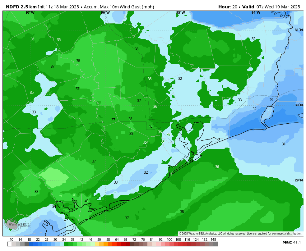
Map of maximum wind gusts for now through early Wednesday. (Weather Bell)

Tuesday

Low temperatures have only fallen to about 60 degrees this morning, and we are going to see warmer weather for a couple of days. The southerly flow will be especially pronounced today, with a tight pressure gradient causing winds to reach sustained levels of about 20 or 25 mph, with gusts up to 40 mph this afternoon. Highs will reach about 80 degrees this afternoon, with a few clouds developing later today.

If you’re headed out to the rodeo, you’ll want to hold on to your hat. Look, I realize I’ve already used that joke this year, but it’s been windy, ok? Although winds may slacken just a bit, they’re still going to be pronounced this evening, along with temperatures in the 70s. The influx of moisture will help keep overnight lows in the upper 60s.

Wednesday

Wednesday morning will be fairly warm and humid, with mostly cloudy skies. Winds should also have finally died down. But it won’t last as a front sweeps in from the northwest during the late-morning hours, likely reaching the coast around noon or shortly after. There is the barest chance of some rain along with the front on the east side of Houston, but I expect a dry passage for nearly all of us.

Highs will be in the upper 70s with sunny skies during the afternoon. And the winds—they’ll have reversed direction, and we can expect gusts of around 20 mph during the daytime, increasing to about 30 mph on Wednesday night. This will create “red flag” conditions for at least western areas of the region, meaning the winds and dry soils will be conducive to wildfires. With the drier air, lows will drop to around 50 degrees on Wednesday night in Houston.

Inland areas of Houston will start Thursday out in the upper 40s. (Weather Bell)

Thursday

This looks to be a splendid day, as it lies in the period between a frontal passage and the return of the onshore flow. Look for highs of around 70 degrees, light winds, sunny skies, and low humidity. Lows on Thursday night will again drop to around 50 degrees in Houston, with cooler conditions for inland areas.

Friday

Another sunny day, with highs in the low 70s. However we’ll likely see some modestly strong southerly winds. Lows only drop into the lower 60s with the warmer southerly flow.

Saturday, Sunday, and beyond

After temperatures mostly in the 70s this week, this weekend and beyond will likely see a warmer pattern, with highs in the lower 80s. We may see one or two weak fronts in the extended forecast, but overall, we should see warmer days and mild nights. Alas there is not a huge signal for rainfall, which we could use right now.