Blue skies for St. Patrick’s Day, and much of this week. It will be windy, too

In brief: This week will bring plenty of sunshine and wind as the region veers through spring. Highs most days will be in the range of 75 to 80 degrees, with some particularly nice weather expected on Thursday. The first half of the weekend looks sunny, but we could see some clouds by Sunday to go along with some slight rain chances.

It is consistently cold across Texas this morning, with a uniformity of temperatures that is not usual for such a large area. (Weather Bell)

Spring-time winds

The wind we experience at the surface is due to air moving from high pressure to low pressure, and the bigger the difference, the greater the breeze. During the summer in Houston, we often talk about the sea breeze. This is because the air over land heats up faster than water during the daytime, lowering the air pressure at the surface. (Warm air rises). Since the air pressure is lower at the surface over Houston, air moves in from the Gulf.

The winds we experienced on Saturday, as a cold front moved in, were different. They were moving from north to south, following the influx of a low pressure system (front) at the surface. The more rapid the pressure change, the stronger the wind. This is what we mean by a “tight” pressure gradient. I bring all of this up because we’re going to see several “tight” gradients this week that will lead to winds whipsawing back and forth across the area.

Monday

Sunday was an absolutely gorgeous day in Houston, certainly a top-10 day of the year. Monday will be similar, although not quite as nice (in my opinion, of course). Highs today will reach about 80 degrees with plenty of sunshine, but this will be marred by southerly winds of about 10 to 15 mph, with gusts up to 25 mph this afternoon.

If you’re heading out to the Houston rodeo this evening, or celebrating St. Patrick’s Day elsewhere, we have no weather concerns aside from the breeze. Temperatures this evening will be in the lower 70s, with clear skies. Lows will be in the upper 60s after the show, and with the warmer southerly flow we probably will only drop to around 60 degrees in Houston overnight. Some inland locations will be cooler.

Tuesday

This should be another mostly sunny day, with high temperatures near 80 degrees. But as the pressure gradient tightens, we’ll see some fairly strong southerly winds at 20 mph, with gusts up to 30 or possibly even 35 mph. This southerly flow will bring humidity back into the region, and give us a warm night in the 60s with increasing cloud cover.

Expect onshore winds on Tuesday. (Weather Bell/SCW)

Wednesday

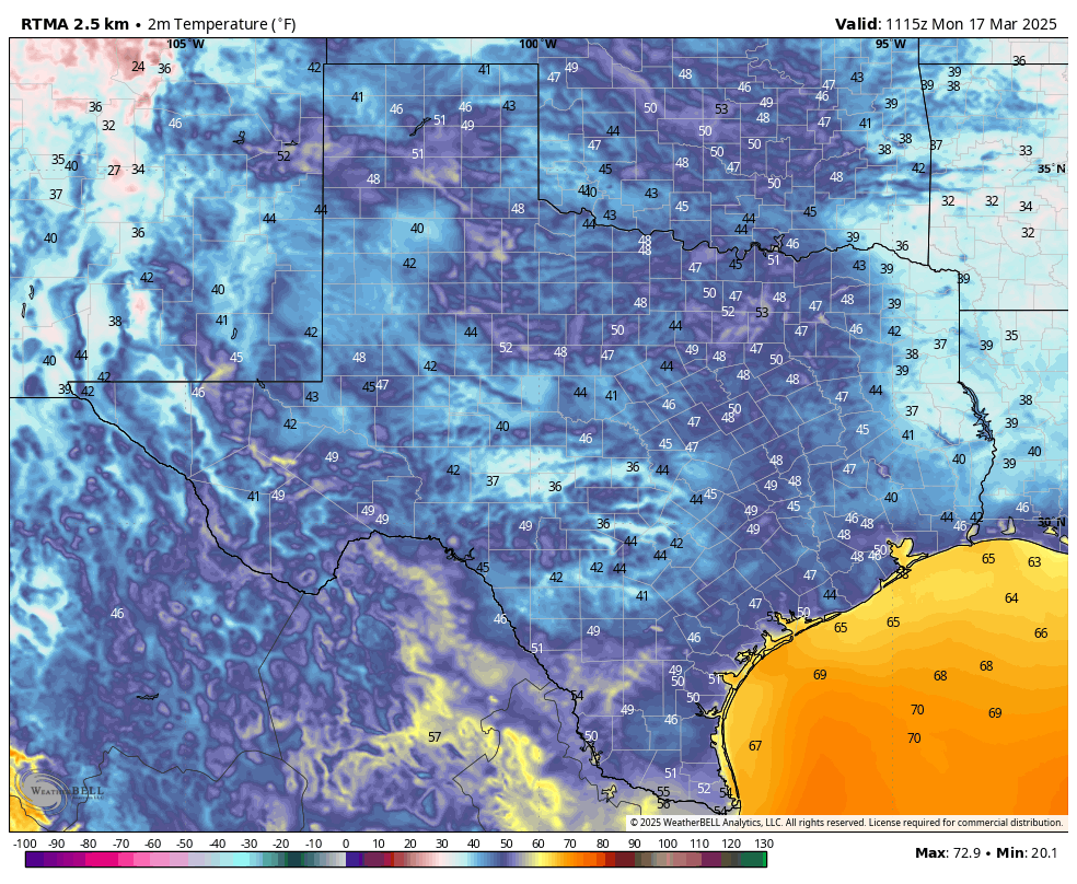
High temperatures on Wednesday should reach around 80 degrees, or even a bit higher in Houston. This is because a cold front is likely to pass through the area during the late morning hours, bringing in drier air (which heats up more efficiently). Expect northwesterly winds during the afternoon, gusting up to 20 or 25 mph. Lows on Wednesday night will be around 50 degrees.
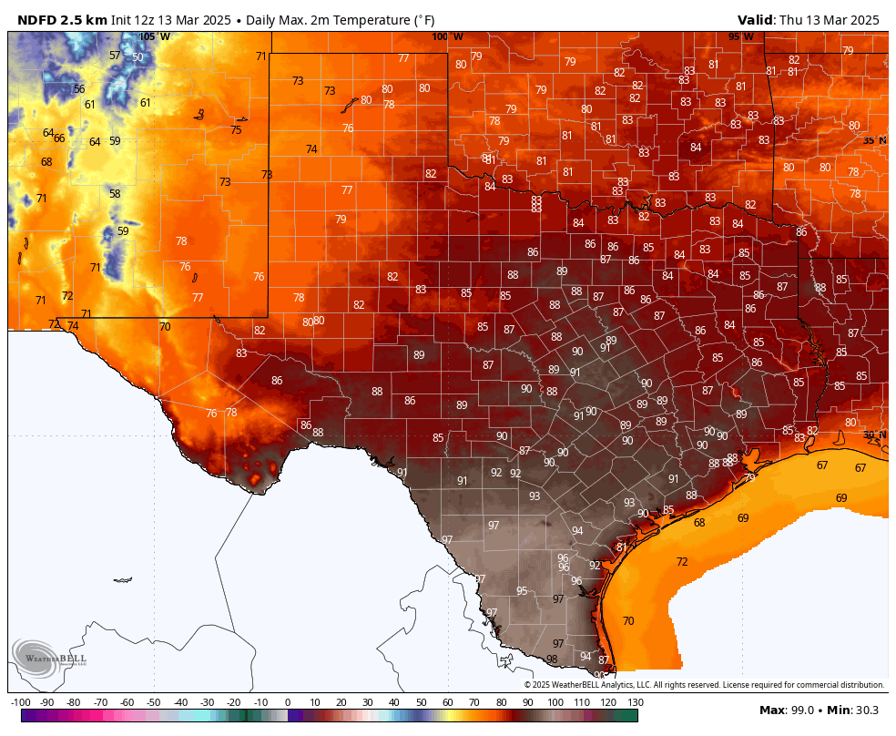
Thursday

At this point, Thursday looks to bring exceptional weather back into the forecast, with highs in the 70s, sunny skies, and light winds.

Friday

By Friday we’ll probably see offshore winds kicking back up, so expect a breezy day in the 70s with rising dewpoints.

Saturday, Sunday, and beyond

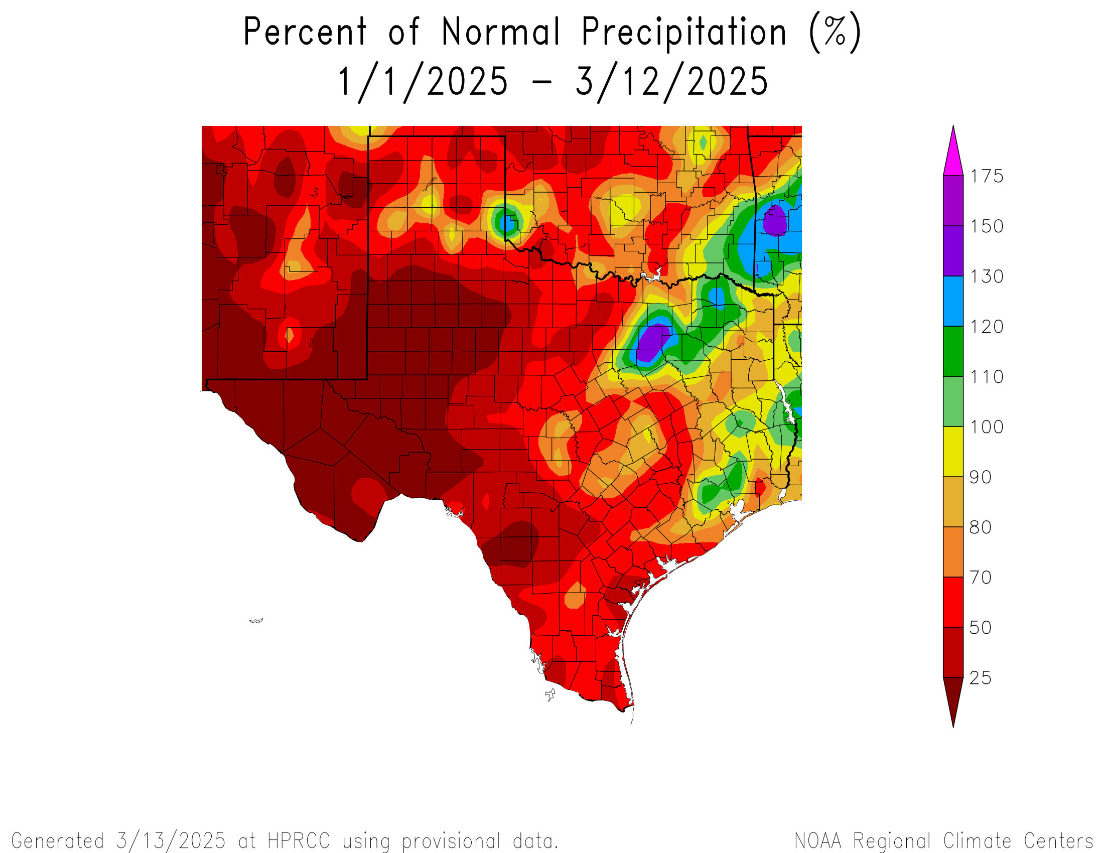
What does the weekend hold? Saturday should be mostly sunny, with highs of around 80 degrees. With a southerly flow in place expect a warm night, with lows in the 60s. As for Sunday, I’m a little less certain. We should see more clouds, highs around 80 degrees, and with increasing moisture there’s a possibility of some showers. (We could use some rain, but this isn’t going to do much to address drying soils I’m afraid). It’s likely that a weak front pushes into the area on Sunday night or Monday, but I’m not confident in the details.

What can Houston’s earliest 90 degree day in nearly 30 years tell us about spring and summer?

In brief: Wildfire risk increases across Texas today and tomorrow as a dry, windy storm system impacts the state. After gusty winds and some fire risk locally on Saturday, things settle down for a few days. We discuss drought, heat, and what’s ahead today.

Big, hot, dry Texas

Houston officially hit 90 degrees yesterday for the first time in 2025. This is our earliest first 90 degree day since 1996, when we did it on February 22nd and the 5th earliest first 90 degree day on record. So yes, it’s quite early for this. The date of our first 90 degree day has been slowly moving forward over the years. It used to typically be in early to mid-May through the late 20th century, and now it’s usually in late April.

Texas drought is deepening and may rapidly get worse in the weeks ahead. (US Drought Monitor)

With the exception of the Matagorda Bay region, most of Greater Houston is not currently in drought this March. However, much of Texas is in drought, with that percentage hovering just above half the state. Areas of extreme and exceptional drought are expanding thanks to a year that has brought most of Texas below average rainfall, in some cases far, far below average.

Texas has been dry most of this year, with the exception of the DFW Metroplex, Houston, and portions of East Texas. (High Plains Regional Climate Center)

Lately, we’ve begun seeing Plains storms with minimal moisture in Texas and strong winds. This combination continues to dry out soils across the state, which will lead to more drought and periodic potential dust storms across the state as well. It is also allowing for a ramp up in high wildfire risk days.

Though the Houston area remains east of the higher wildfire risk across Texas today, the northwest part of the state is under extremely critical wildfire risks. (NOAA SPC)

While we don’t need to worry much about wildfires in Houston proper right now because of our relative abundance of moisture this year compared to the rest of Texas, it is possible, if not likely that we will continue to see relatively frequent wildfire risk across the state and up into Oklahoma in the weeks ahead.

We can predict that your next question will be “what does this mean for summer?” And the answer is that it’s too soon to connect what we are seeing now with summer, or at least too soon to connect them closely. Could this mean a hotter and drier summer than usual? Maybe. But it’s not anything I’d be going to Vegas and betting on just yet. For the rest of spring, however, this drying and warming trend is a bit troubling for those hoping we could avoid drought expansion. Something to continue watching.

Today

While the wildfire risk is extreme to our west, here in Houston it will be breezy and at least a little humid today. Wildfire risk begins to ramp up as you go into and west of College Station where Red Flag Warnings begin. The risk is highest in Hill Country, the Permian, Caprock, Panhandle, and North Texas into Oklahoma. We should see decreasing clouds today with temperatures popping back into the mid-80s, if not upper-80s in spots.

If you’re headed to see Journey tonight at the Houston Livestock Show & Rodeo, you’re in luck, as the weather will embrace you with open arms. Temperatures will ease back into and through the 70s, leading to a comfortable exit in the evening. Breezy conditions on Friday afternoon should settle down after sunset. No rain is expected.

Saturday

The cold front gets here around or just after sunrise on Saturday. I don’t want to entirely rule out a passing downpour or thunderstorm, but that currently looks to stay well to our north and east. Any rain or storms would be quick before exiting. We should then open up to sunshine after some lingering clouds. Severe weather risks on Saturday are quite significant to our east in eastern Louisiana and Mississippi, so if you’re returning from the eastern Gulf Coast as spring break ends, just keep that in mind on Saturday afternoon.

Although Saturday’s severe weather risk is comfortably east of Houston, if you are returning from Florida after spring break this weekend, keep in mind that conditions from Louisiana through Alabama will be volatile Saturday afternoon and evening. (NOAA SPC)

Winds will begin gusting around midday Saturday, not too dissimilar to what we saw early last week, with gusts perhaps as high as 40 or 45 mph possible by Saturday afternoon. Those winds will die off after sunset. In addition to the gusty winds, humidity levels will plummet, with dewpoints possibly dropping into the teens. It will be desert-like air with highs around 80 degrees.

Wildfire risk may be a bit higher closer to Houston on Saturday due to the winds and low humidity. While our soil moisture is in better shape than it is to our west, that fire risk is definitely not zero on Saturday afternoon and the aforementioned combination of wind and humidity may lead to a Red Flag Warning perhaps up to I-45. Conditions will improve after sunset.

Sunday and Monday

The rest of the weekend into Monday looks great. There should be ample sunshine and a bit less wind with highs in the 70s and lows generally in the 50s.

Rest of next week

Expect a warm up back into the 80s for the middle of next week ahead of a storm system in the Wednesday or Thursday timeframe. This one looks a bit weaker and farther north than this weekend’s system, so while we may turn breezy and have a chance of a shower or storm, the weather from that storm will probably be a little less crazy across Texas and the South. Still, we may need to discuss wildfire risk in parts of Texas next week yet again.

Parts of Houston may reach 90 degrees today for the first time in more than four months

In brief: It has been 136 days since the city of Houston officially recorded a 90-degree day, back on October 27. Today, that may change. Parts of the region will hit likely hit 90 degrees. But that does not mean spring is over. Most of the next 10 days, including this weekend, should continue to bring beautiful, spring-like weather.

Coastal areas of Texas are quite warm this morning while much of the state is cooler. (Weather Bell)

Thursday

After patchy fog clears this morning we should be left with sunny skies. The combination of a warm southwesterly flow and a bit of drier air will allow high temperatures to pop up today, with much of the Houston area in the upper 80s, and locations to the west and southwest of the city likely reaching 90 degrees. Only the coast will remain at about 80 degrees. Winds at the surface will, generally, be light at 5 to 10 mph from the southwest.

If you’re heading out to the rodeo this evening be sure to get there early, because a good friend of our family will be singing the national anthem to kick things off. It will be warm this evening, in the mid- to upper-80s. Temperatures will have fallen into the 70s after the show is over. Low temperatures tonight will only fall into the upper 60s for most of the metro area.

Another consideration for tonight’s weather is the lunar eclipse. Totality, at which point the Moon is tinted a coppery red, lasts from 1:26 am CT to 2:31 am CT. Unfortunately skies will likely be partly to mostly cloudy. However, there should be some breaks in the clouds that will allow for visibility of the celestial phenomenon.

Friday

With partly cloudy skies on Friday, and more pronounced southerly winds, high temperatures should be a few degrees cooler, probably in the mid- to upper-80s for most of the region. Given that a cold front is unlikely to push through Houston before Saturday morning, I expect another warm night on Friday, in the mid-60s.

Although it will be warm in Texas on Thursday, check out those highs in the Valley. (Weather Bell)

Saturday

The frontal passage looks to be a dry one, but we cannot rule out a few showers on Saturday morning. However skies will quickly be turning sunny, and northerly winds at about 15 mph, with higher gusts, will be usher in lower humidity. Look for high temperatures around 80 degrees, with lows on Saturday night dropping into the mid-50s in Houston, with cooler conditions for inland areas.

Sunday

Expect a truly splendid day, with highs in the mid-70s, sunshine, low humidity, and light winds. This will be a top-10 day in Houston this year, weather-wise. Lows on Sunday night may push down near 50 degrees.

Next week

Monday should be in the 70s again before we push up near 80 degrees on Tuesday and Wednesday. Skies should remain mostly sunny throughout. A front on Wednesday will probably knock us back into the 70s for the second half of the week. If you’re wondering about precipitation, we could see a decent shot of rain about 10 days from now. We’ll see.

The region’s first real heat of the year arrives during the next couple of days

In brief: After near to below-normal temperatures for much of the last 30 days in Houston, the pendulum swings warmer again. We will have our first flirtation with highs of around 90 degrees by Thursday, although a nice front arrives to usher spring-like weather back into Houston this weekend.

Early season heat

If you remember about a month ago, the city experienced a sold week of high temperatures in the low- to mid-80s during the first 10 days of February. During that time we set several record highs, as well as record warm nighttime temperatures. This spell was followed by a much colder second half of the month. Now, we are about to take another step up in temperatures for a few days this week, with highs in the upper 80s. The record highs for both Thursday and Friday in Houston are 88 degrees, and we’re going to make a run at those records both days. Could someone hit 90 degrees? Some areas to the southwest of Houston definitely have a chance on Thursday.

So far, this month, Houston has has fairly seasonable temperatures. (NOAA)

Wednesday

We’re seeing some patchy fog across the region this morning, but it will burn off as temperatures rise today. Houston will not be as warm today as it will be on Thursday and Friday, but highs should still reach the lower 80s away from the coast, with mostly sunny skies. There is a slight chance of some showers later this afternoon or evening, in association with a weak front. However, chances are low, and likely to be confined to areas north of Highway 105. The most notable feature today will be winds from the south at about 15 mph, with occasional gusts up to 30 mph.

If you’re heading to the rodeo expect temperatures in the upper 70s early this evening. Those winds I mentioned will be peaking late this afternoon and into the early evening, so expect a fairly stiff breeze as you’re moving about. Winds will have died down a little bit after the show, but only a little. Expect temperatures of about 70 degrees late this evening, dropping into the mid-60s by Thursday morning.

Thursday

The combination of some briefly drier air and a warm southerly flow will allow high temperatures to really pop on Thursday. With sunshine, I expect most of Houston to reach the upper 80s, with possibly a few southwest locations reaching 90 degrees for the first time. Lows on Thursday night will again be mild, in the mid-60s.

Forecast for maximum temperatures on Thursday. (Weather Bell)

Friday

This will be another warm day. How warm depends on the extent of cloud cover, but I expect most of Houston to once again get into the mid- to upper-80s. Lows Friday night will drop into the low- to mid-60s again.

Saturday and Sunday

The arrival of a front on Saturday morning (likely with no rain, or very light showers at the most) will set up a splendid weekend. We’re talking dry air and highs in the 70s, and overnight lows around 50 degrees. Saturday may be a little windy with the front’s arrival, but I’m hopeful that gusts will only peak around 20 mph. In any case it should be a gorgeous, spring-like weekend.

Next week

We’ll warm up back toward 80 degrees on Tuesday and Wednesday before another front swings through to keep the spring party going during the second half of next week. There’s not a strong signal for rain with the mid-week front, but at this point, who can say?