Two things to watch for this week: Heat on Thursday and a Lunar Eclipse

In brief: Houston’s weather remains mostly calm for the foreseeable future. Two things to watch for this week are uncharacteristically hot temperatures on Thursday, and then a lunar eclipse later that night. Hopefully we’ll see partly cloudy skies so the eclipse is viewable.
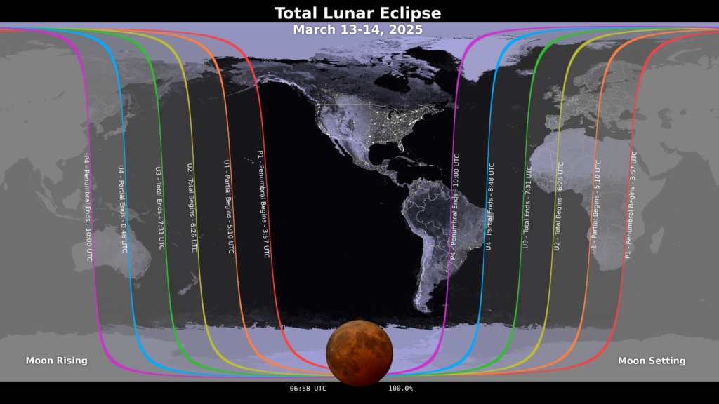
Lunar Eclipse

The greater Houston region, indeed all of North America save for the western half of Alaska, will be treated to a total Lunar Eclipse on Thursday night. Unfortunately the eclipse will occur rather late, with the Moon entering the Earth’s umbra (darkest part of its shadow) at 12:09 am CT on Friday morning. Totality, at which point the Moon is tinted a coppery red, lasts from 1:26 am CT to 2:31 am CT. NASA has more information about the eclipse here. So will it be cloudy? I believe our region will see at least partly cloudy skies, and I expect that to increase to mostly cloudy by sunrise on Friday morning. So the forecast is not ideal. However, the totality will last long enough such that I do expect some breaks in the clouds that will allow the eclipse to be visible.

Areas that will see a total lunar eclipse on Thursday night. (NASA)

Tuesday

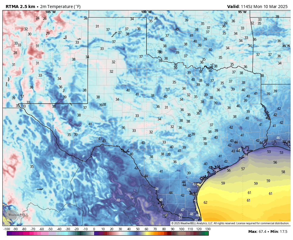
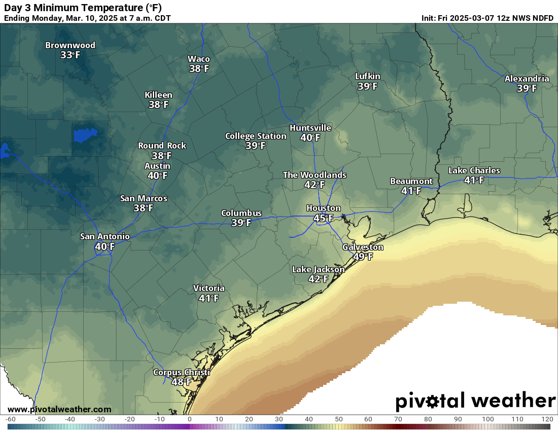
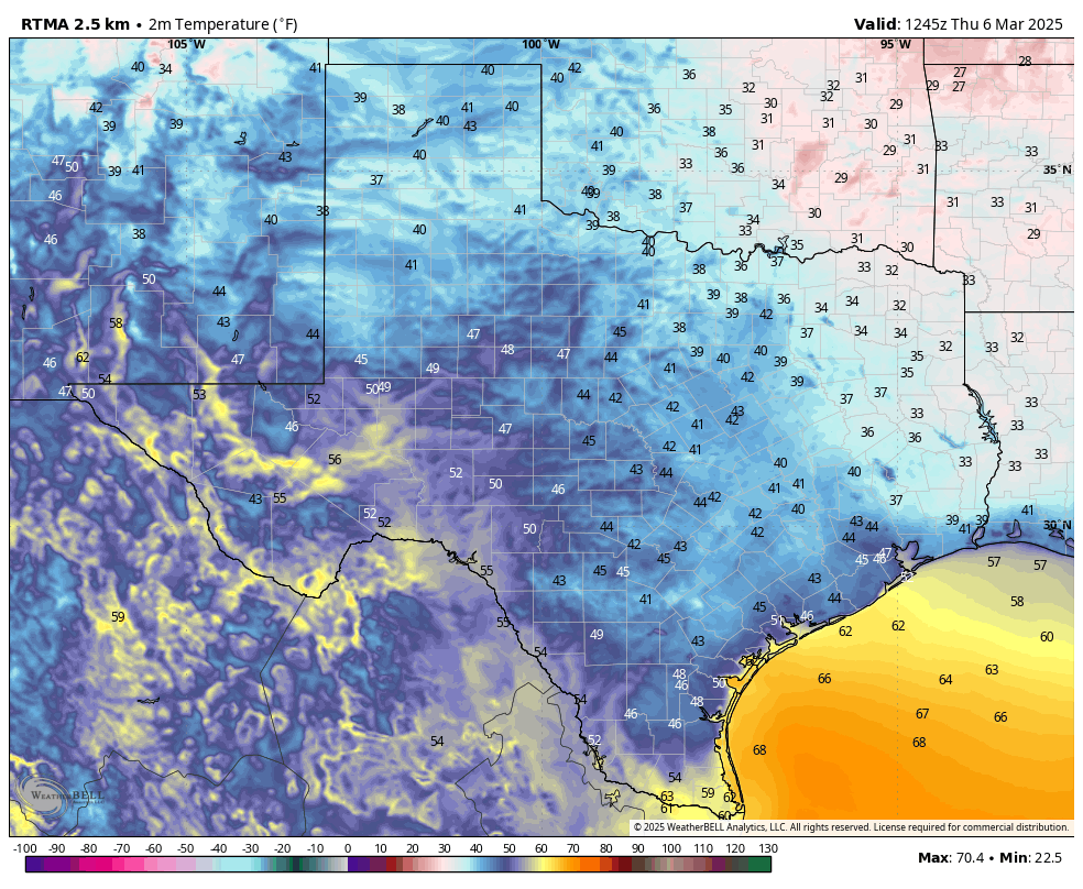
After Monday’s splendid weather we have another pleasant day on tap, with mostly sunny skies. After temperatures start out this morning in the upper 40s, we’ll see highs reach the upper 70s. Expect southwesterly winds, with a few gusts up to 15 or 20 mph later this afternoon. All in all, very, very nice outside today.

There are zero weather concerns for the Houston Livestock Show and Rodeo this evening. Temperatures will be mild, in the lower 70s, heading into the show, with a breeze from the southwest. After the show, it will be in the low- to mid-60s outside, with mostly clear skies. Lows on Tuesday night will only drop to around 60 degrees with the warmer, southerly flow.

Wednesday

After the potential for some fog on Wednesday morning, we should see a mostly sunny day, with highs reaching around 80 degrees. A weak front will push through, but it’s not going to change much other than bringing some slightly drier air that will play into Thursday’s weather. Low temperatures on Wednesday night will only drop into the low 60s.

Thursday

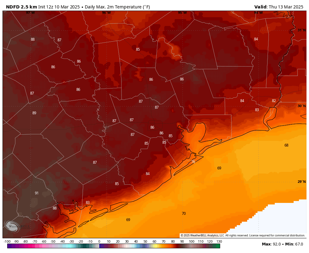
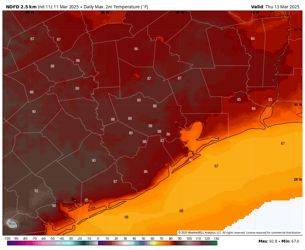
The combination of slightly drier air and warm air advection from the southwest will lead to a very warm day on Thursday, with some parts of the Houston metro area possibly hitting 90 degrees. Most of us should remain in the upper 80s, but it’s going to feel warm regardless, especially for mid-March. Low temperatures on Thursday night will fall into the mid-60s.

High temperatures on Thursday will be toasty indeed. (Weather Bell)

Friday

The development of some clouds may help put a lid on temperatures Friday, holding them generally to the mid-80s. But it will still feel rather warm outside, with a fair amount of humidity. A cold front is coming, but it probably will not arrive until early on Saturday, so expect a fairly warm night.

Saturday and Sunday

I don’t expect much in the way of precipitation with the front, perhaps a few light showers, we’ll see. Quickly afterward we should see clearing skies, probably some time on Saturday morning. As a result we’ll be left with clear skies and lower humidity for the remainder of the weekend. Look for highs in the vicinity of 80 degrees and nights around 50 degrees, give or take. Seriously, this will be an exceptional weekend for outdoor activities.

Next week

We should see a gradual warm-up next week through about Wednesday, at which some point some sort of front is likely to trundle through. Whether this brings us any rain is anyone’s guess. I’ll give it a solid maybe.

Houston’s mild weather continues for at least the next week, with some top-10 days

In brief: Spring remains in full bloom this week for the Houston region, with some exceptional weather on tap. Monday looks incredibly nice, and you can plan outdoor activities for next weekend with some confidence. All in all, it’s just a pocketful of pleasant.

It is a chilly morning across the entire state of Texas. (Weather Bell)

A note about site comments

Since the inception of Space City Weather nearly a decade ago, we have had an open comment policy, with limited moderation. A nice community has developed here, with generally good and polite discussion. (Polite being the operative word). However in recent months there have been about a half dozen people stirring the pot with, at-times, nasty and attacking comments. We don’t have any full-time staffers to moderate comments, so we have addressed these where possible, and sometimes late. Unfortunately, if this continues, we are going to have to move to a system whereby all comments must be approved before publication. I’d rather not do that, but it may be necessary to weed out the personal attacks.

Monday

Today is going to be terrific. Several times a year, during the spring and fall, I will call out a day as being a “top-10” day, meaning I feel like it is one of the nicest days of the year in Houston. This will be one of those, with high temperatures in the lower 70s, light winds, plenty of sunshine, and low humidity. Honestly, it’s going to be amazing, so soak it up.

It will be great weather for the Houston Livestock Show and Rodeo, as well. Temperatures will be in the upper 60s as you head into the show, falling to around 60 degrees afterward. By this evening our light northerly winds will have shifted to come from the south, but they’ll still be light. Low temperatures on Monday night will fall to around 50 degrees in Houston, with cooler conditions for inland areas.

Tuesday

This will be another sunny day, with high temperatures in the upper 70s. Winds will be from the south or southwest, and we may see a few slight gusts during the afternoon hours. With a warmer flow in place, lows on Tuesday night will likely only fall into the upper 50s.

Wednesday

Skies will be mostly sunny, with highs around 80 degrees as the southerly flow continues. Lows on Wednesday night will only drop into the lower 60s. Some areas north of the Houston metro area may see some showers or thunderstorms due to a passing system, but for now I expect the majority of the Houston region to remain dry. We’ll see.

Thursday

With the influx of a bit drier air, Thursday should be the warmest day of the week. High temperatures could reach the mid- or even upper-80s for the Houston area. So this probably will be our warmest day of 2025 so far. Lows on Thursday night will only drop into the mid- to upper-60s.

High temperatures on Thursday look a little toasty. (Weather Bell)

Friday

Expect a mix of sunshine and clouds, and high temperatures in the 80s, ahead of a modest front. There’s a low chance of some showers or thunderstorms with this front, and if they occur it likely would be later on Friday or Friday night.

Saturday, Sunday, and beyond

This weekend looks very nice in the wake of the front. We’re talking highs likely in the upper 70s, with plenty of sunshine and modestly drier air. Lows on both nights will fall into the low- to mid-50s, probably. It all just looks very mild and spring-like. We should warm into the 80s next week before another front possibly arrives. Overall rain chances appear low for the next 10 days or so.

A brief return of humidity through Saturday in Houston, then back to chamber of commerce weather

In brief: After a delightful pair of days in Houston, the humidity returns today. The weekend will not be a washout, but there may be some showers or even a storm around on Saturday before we cool off significantly and clear out on Sunday. Then, buckle up for a splendid start to spring break week for those who celebrate.

Today

The last couple days have been incredible around the area with low humidity and extremely comfortable temperatures. One could gripe with the wind a bit, but nothing’s ever perfect. Today will see a bit of a change. Humidity will begin increasing again as onshore flow resumed yesterday afternoon. Dewpoints rose into the 40s yesterday evening, and they’ll push into the 60s by this evening marking the return of more “clammy” Houston weather. Aside from that, we will see increasing clouds as well with highs into the 70s. With a little sun, we could test 80 degrees this afternoon.

Will the weather be trill for Bun B’s birthday bash? No, but it won’t cause you any headaches. Temperatures will drop back into the lower 70s through the evening, but the humidity will make it feel a touch damp. Otherwise, no rain is expected for this evening. Nothing “Ludacris” (alert alert) about that.

The weekend

A cold front is going to push through the Houston area tomorrow night. Ahead of it, there will almost certainly be scattered showers or a few rumbles of thunder during the daytime and evening hours Saturday. The Storm Prediction Center has areas just off to our northeast under a marginal risk (1/5) for severe storms, which is to say we probably won’t see anything too earth-shattering in the Houston area.

There is a marginal risk (1/5) of some stronger thunderstorms north and east of the Houston area on Saturday afternoon or evening. (NOAA SPC)

Still, don’t be shocked to hear some thunder Saturday. Morning lows won’t get much below 70 degrees and daytime highs should be in the low-80s. There could be areas of patchy dense fog near the coast. That front sweeps the humidity and any fog back out into the Gulf on Sunday, and we get a taste of late winter with a good bit of sunshine. Morning lows will start in the 40s Sunday and warm into the low-60s, if that on Sunday afternoon. It will also be a bit breezy at times once again. Bust out the jackets!

Monday morning’s low temperatures look cool! (Pivotal Weather)

Monday & Tuesday

Next week starts off delightful with highs in the low-70s and morning lows in the 40s. Expect lots of sunshine, so for those of you staying close for spring break, prepare to deal with lots of crowds in the usual outdoor spring break magnets. But with weather this nice, perhaps it’s worth it! Truly chamber of commerce weather.

Rest of next week

For those who think the 70s and 40s routine is a bit tired and cool, good news. Temps will warm into the 80s on Wednesday and Thursday, possibly even the mid-80s. Look for our friend the wind to return late next week, possibly quite gusty by Friday or so. There may be a shower or storm in the forecast by Wednesday or Thursday.

Plenty of springtime weather is on the menu for Houston through the middle of March

In brief: There are few weather concerns for the foreseeable future in Houston, with plenty of sunshine and a mix of warmer and cooler air. This is springtime at its finest in Houston, our period of lovely weather before humidity and heat fully set in a couple of months from now. Embrace the outdoors!

For a state as big as Texas, the temperatures are fairly consistent across the state this morning. (Weather Bell)

Thursday

The weather today is going to be mighty fine. We are looking at sunny skies, with high temperatures around 70 degrees, and low humidity. Although winds will be calm this morning, they will start to pick up from the south this afternoon, with some gusts possible near 20 mph. This will herald the return of the onshore flow, and warmer weather through Saturday

For those headed to the Houston rodeo this evening, there are zero concerns in terms of weather. Temperatures heading into the show will be in the mid-60s, with a bit of southeasterly wind. After the show it will be about 60 degrees, with a bit more humidity in the air. Temperatures won’t go much lower overnight, as the warmer flow pushes into the region.

Friday

This will be a warmer day, with some cloud cover possible as atmospheric moisture levels increase. We’ll see more southerly winds, with some gusts up to 20 mph. High temperatures will reach about 80 degrees on Friday, and with dewpoints in the 60s it will feel a little bit sticky outside. Accordingly, lows on Friday night will only drop into the mid-60s for most locations. A few, very light showers will be possible after midnight.

Saturday

We should start out with mostly cloudy weather on Saturday morning, and plenty of humidity. A few light showers will be possible throughout the day, with a slight chance of some thunderstorms during the afternoon with the passage of our region’s next cool front. Right now I think this will be a quiet passage, with most of the area seeing on the order of one-tenth of an inch of rain, or even none on Saturday. But we cannot rule out some daytime showers briefly disrupting outdoor activities. Highs will be around 80 degrees, with clearing skies during the afternoon hours likely in the wake of the front’s passage. Expect gusty northerly winds later on Saturday, but nothing like the region experienced on Tuesday. Lows on Saturday night will probably drop into the upper 40s.

Sunday

This will be a fine, sunny day with highs in the mid-60s. Winds will be from the north, with possibly some gusts up to 20 mph as drier air moves in. Lows on Sunday night may reach the mid-40s in Houston, with cooler conditions for inland areas. Expect a nice chill in the air.

Temperatures on Monday morning should be the coldest of the forecast period. (Weather Bell)

Next week

Most of next week will see plenty of sunshine, with high temperatures in the 70s and 80s. A bit of a stronger front could arrive by next weekend to cool the region down some. Rain chances look fairly low, to non-existent throughout the period.