The SCW Q&A: Cap busting, pancake ice, pollen week, best weather apps

It’s another just-in-the-nick-of-time edition of the Space City Weather Q&A. If only we could get a few more days added to each month, maybe we’d get this out the door sooner. Or maybe April’s edition would just end up publishing on April 33. Who knows?

Anyway, let’s get to it. As always, if you have a question for next month, drop it in the comments below or hit the Contact link on the blog home page.


Q. I’ve been noticing over the last few months. The last couple of major storms that were supposed to be severe, once they came thru Harris County were unable to break the cap. What is causing that to happen? Is this common in La Niña springs?

A. Welcome to weather forecasting, my friend. The reality is there are a lot of variables needed for storms to develop, and sometimes they’re very difficult to forecast.

You mentioned La Niña, a cooling of the tropical sea surface temperatures of the Pacific Ocean. It’s not entirely clear to me whether we’ve been in a very weak La Niña or neutral conditions since about February, so I really don’t think that’s a factor. We also have seen some pretty decent thunderstorms this spring, it’s just that all have not hit. The reality is that sometimes storms make it, and sometimes, whether it’s a lack of instability or other factor, they don’t.

I would also add that spring storm season is not over. It typically lasts through much of May before we get into a pattern more dominated by high pressure in June. If you’ll recall, the destructive derecho that hit Houston last year did so on May 16. So, like, knock on wood or something. –

Eric

Q. A reader visiting Hamburg, NY, reached out to ask: We visited Woodlawn State Park, on Lake Erie. The “beach” had frozen iceberg formations (which was still cool to a Texas girl). Not really an iceberg, they were small frozen disc situations. But the interesting part was: the ‘iceberg’, when you ran you finger across the side: ice crystals or icicles easily poured off the side of it. So the “icedisc” (or iceberg for dramatic effect) was actually made of these ice crystals. What was going on there?

A. As the resident Upstate New York veteran, I will say that what you probably witnessed was a phenomenon known as “pancake ice!” My tell is that you said you ran your finger across it and ice poured off the side. Pancake ice usually has raised edges, so that seems to check out. Sweet as it may sound, pancake ice forms in an interesting way.

Lake Erie is the shallowest Great Lake, so it tends to freeze over in wintertime. It starts with a slushy, thin ice that forms initially. Over time, that slushy, greasy ice will thicken up and becomes what is known as nilas ice. This is where you start to see an ice sheet develop. If it gets cold enough, long enough, and the ice thickens more than 4 inches, that becomes known as “first-year ice.” It always warms up enough to melt Lake Erie’s ice, so as that process begins and we start to see more of a transition season occur, with warm spells peppered by cold blasts, that’s when some fun ice formations can occur.

Pancake Ice! (Stanisław Węsławski, CC BY-SA 4.0 https://creativecommons.org/licenses/by-sa/4.0, via Wikimedia Commons)

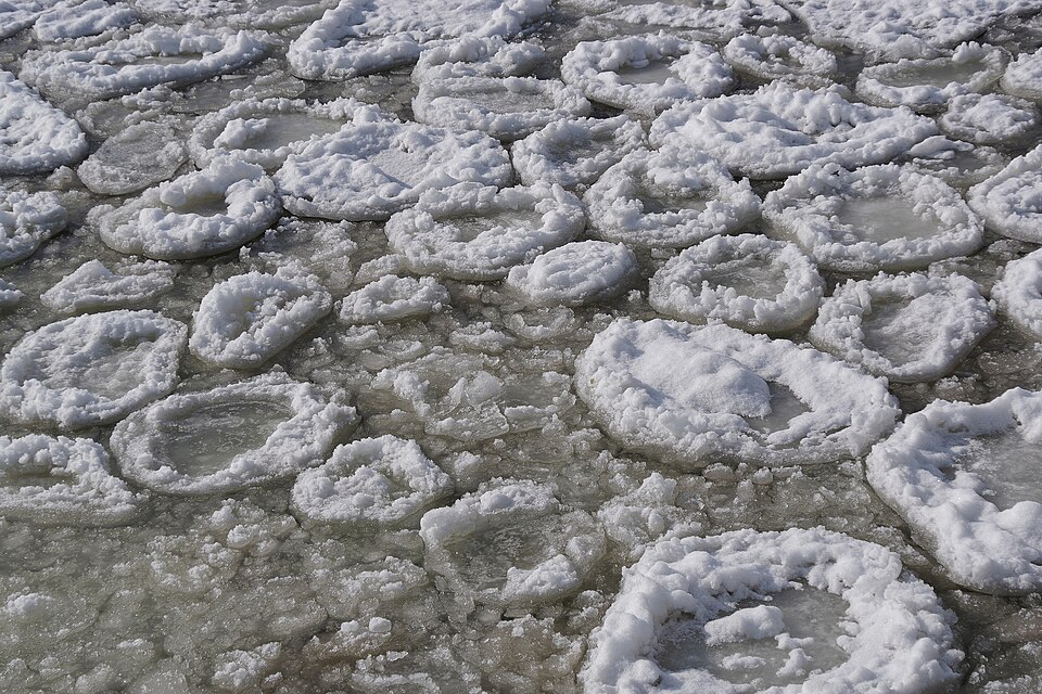
In the case of pancake ice, you get some of that thinner ice that crashes into other thinner ice and forms disc-like shapes in rough water. Basically, the wave action smooshes some of the thinner ice together into discs. Those discs can hit other discs and you get a saucer shape with raised edges. Hence, pancake ice.

The Great Lakes are a fascinating place. Between some of the ice features, lake effect snow, lake breezes, and more, it’s a fun place to practice meteorology.

–Matt

Q. Every spring there’s this period of a couple weeks (maybe more?) when everyone’s car is covered with yellow pollen. I have two questions about this: Is the week when this starts predictable each year, like “third week in March is pollen week”? And is how long it lasts predictable, as in “when will I be able to wash my car”? Or are we at the mercy of the pollen gods every year?

A. There is essentially pollen all year long in Houston, but you’re referring to tree pollen and most particularly pollen from oak trees that cake anything left outdoors in yellow and green. There is no set period for this because when it occurs depends on the weather. A longer and colder winter will delay pollen season, and a shorter and warmer weather will cause trees to bloom earlier. Typically tree pollen season peaks during March or the first half of April, but not always.

Pollen coating cars is a sure sign of spring in Houston. Also: Achoo! (Dwight Silverman photo)

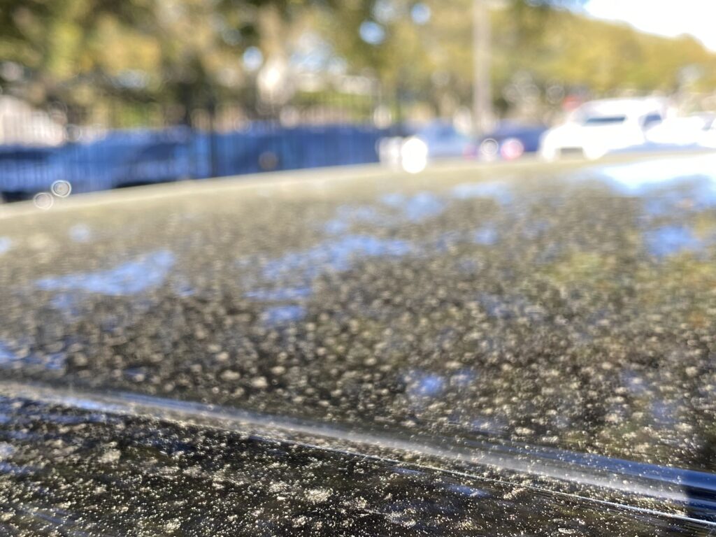
The height of oak pollen season lasts about two or three weeks, but again this duration depends on the weather. Windy conditions and heavy rain can bring more pollen down sooner, whereas mild conditions can extend the time. But the good news is that once oak pollen season is over, it’s over. And we’re left with these amazing, leafy old trees that provide shade during the long and hot summer months. I consider it a fair trade. If you’re interested in data, the city of Houston has a good website that tracks all manner of pollen in the air, on a daily basis.

–Eric

Q. I have several weather apps on my phone, and I’m kind of a weather nerd so I am always looking at others. I have the Space City Weather app, obviously, but I’m curious: Other than that one, what is is Matt’s and Eric’s favorite app and why?

My favorite free weather app that I can recommend to people without hesitation is an app called Everything Weather, by Cory Mottice, for both iOS and Android. Why do I like this app? No ads for one thing. Secondly, it’s almost entirely National Weather Service data, and immediately you are presented with any hazards for your location.

Screenshot of “Everything Weather” forecast screen. (EverythingWx)

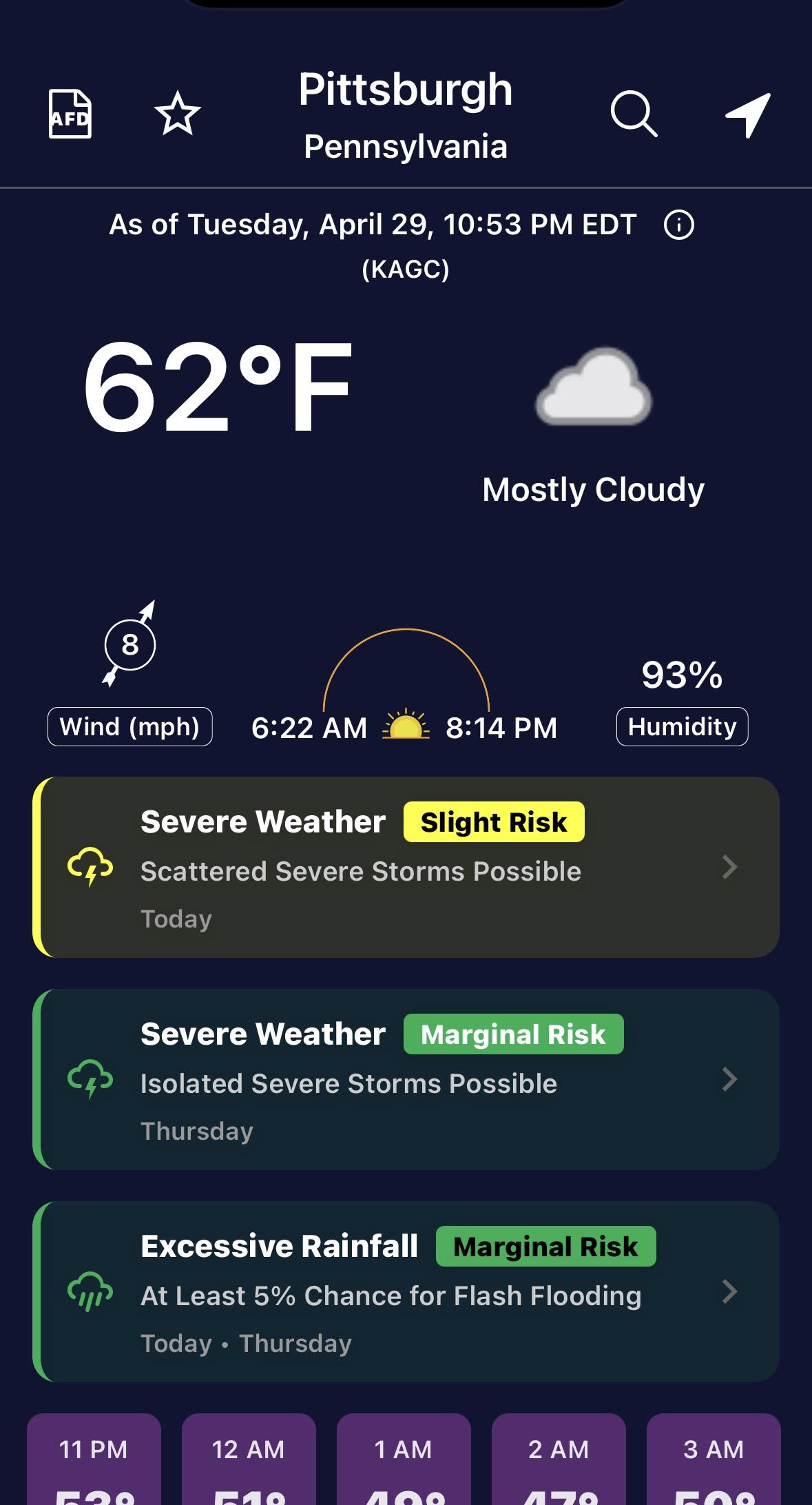
You can see above that for Pittsburgh there is a slight risk of severe weather on this day, a marginal risk Thursday, as well as a marginal risk of excessive rainfall. You can scroll down and tap whatever day you want for a brief description of the forecast.

Scroll to the bottom and find your local NWS office’s “weather story,” which adds critical context to a daily forecast, particularly when bad weather threatens. You can also tap “AFD” at the upper left and instantly read the NWS’s technical forecast discussion for that area.

Basically, it accomplishes the rare feat of giving a ton of information to both average consumers and more sophisticated weather nerds in one app on one screen. It also has radar functionality, though no dubious rain alerts that are very hit and miss in other apps. You can also customize what threshold you want for NWS alerts, or you can say I want “Open Meteo” weather data instead of NWS.

One drawback? No push alerts that I am aware of. So if you want immediate notification of weather warnings, you’ll need to shop around.

–Matt

My favorite app is Spotify. When I was growing up I had an allowance of $10 a week and a summer job detasseling corn that paid a pittance. Between regular trips to the CD store and Columbia House, I was able to cobble together a music collection. Sometimes, when money was tight, I would resort to taping new releases played on the radio with a cassette tape. It now seems pretty magical to be able to listen to any song I want to, at any given moment, from across the history of recorded music.

Oh, wait. You meant weather app.

RadarScope is about as good as it gets when comes to showing storm information.

As always, I think RadarScope is the best weather app because it provides essential radar information during inclement storms. Never leave home without it!

–Eric

Nobody asked me, but I’ll second Eric’s RadarScope endorsement, and add that it’s available for almost every platform. For Apple users, it works on iPhones, iPads, Macs, Watch and even the Apple TV streaming box. The paid features (two tiers) give you lots of details, such as storm track and lightning strikes, and if you pay once for the Apple version, the pro features are available on all those devices. It’s also available for Android and Windows, though you must pay separately for each of those.

Want more weather apps? See my post from last July about how to use phone apps to pinpoint weather forecasts at your location.

Storms are possible late tonight in Houston, but far from a certainty

In brief: Houston will now enter a somewhat wetter period in which rain will be possible most days. In addition, after a couple of fairly hot days, a weak front should bring some slightly drier air into the region for this weekend, knocking humidity down a bit.

Wednesday

As noted in yesterday’s post, we’re now entering a period over the next week or so in which it probably will not rain every day, but rain should be possible most days. Today, an upper-level system will drive a chance of scattered showers this morning, followed by partly sunny skies this afternoon. Depending on cloud cover, highs today will likely reach the low- to mid-80s. We’re going to have one more day of pronounced southerly winds, gusting to 25 mph, or higher.

The HRRR model is depicting a line of storms approaching Houston at 2 am CT on Thursday morning. But will it actually materialize? (Weather Bell)

Tonight the pattern becomes more interesting, as a line of storms approaches the region from the north. But how far will it progress? These showers and thunderstorms, some of which could be severe, will likely approach the region around midnight and could push south of Interstate 10 by sunrise on Thursday morning. However, this is no slam dunk. While some ingredients are in place to support such a line of storms moving across Houston, I think there’s a 50 percent or less chance it actually materializes.

Thursday

By mid-morning on Thursday, at the latest, any residual storm activity should have moved off to the east, leaving us with a partly sunny and warm day. Some areas are likely to get into the upper 80s, and we can’t rule out a few 90-degree readings for areas well inland. Lows on Thursday night will fall to around 70 degrees with mostly cloudy skies.

Friday

This will be another warm-to-hot day, with temperatures in the upper 80s for most of the area. Beginning Friday afternoon, we’ll see increasing rain chances due to an approaching front. We’re far enough from this front to not have great details yet about potential storms, but the bottom line is that there will be a healthy chance of rain from Friday evening through Saturday morning, and possibly into the early afternoon hours on Saturday in Houston, as the front drifts in.

Saturday

The first half of the weekend, as noted above, will see a good chance of showers before the afternoon hours. Expect highs of around 80 degrees, with clearing skies later in the day. There is a fair amount of uncertainty about temperatures, but lows in the mid-60s are possible on Saturday night going into Sunday morning.

Sunday morning may be cooler than we’ve experienced of late. (Weather Bell)

Sunday

I’m cautiously optimistic about Sunday being a really nice day. Humidity is not going to be low, per se, but it could be quite a bit lower than we’ve experienced of late. What would you say to high temperatures in the low 80s, partly sunny skies, and relatively low humidity in early May? It won’t be perfect, and there will probably be some isolated to scattered showers later in the day. But as we get closer to summer, beggars cannot be choosers.

Next week

Most of next week should see highs in the mid-80s. High pressure will likely shut down rain chances to start the week, but by Tuesday or Tuesday night we could see the return of some showers and perhaps a few thunderstorms. We shall see.

Houston to turn warmer and wetter before the possibility of a weak front this weekend

In brief: After several drier days, some rain chances will return to Houston’s forecast. We are not expecting any days really to be washouts, however. I’m also holding out some hope that a weak front makes it into the city this weekend, providing for some slightly drier and cooler air. Fingers crossed.

Overall pattern shift

The high pressure that has held sway since last Friday, and basically shut off rain chances since then, is now shifting to the east. This does not mean you will see rain every day from now on, but over the next 10 days there will be at least a slight chance of rain most days. Total accumulations over the next 10 days may only be 1 to 2 inches, so we don’t have any real flood concerns at this time. It just should be a pattern that provides the potential for spoiling a few outdoor activities, but also helps our trees and plants before the long summer days that lie in our near future.

Tuesday

With that said, rain chances today are rather slight, and anything that falls would be a quick passing shower. However that does not mean sunshine will be abundant. Rather we should see mostly cloudy skies, and this will help limit high temperatures in the mid-80s for most locations. With dewpoints in the 60s it will feel moderately, but not oppressively humid. We can expect southerly winds at about 15 mph, with gusts this afternoon up to 25 mph. Overnight lows will only drop into the mid-70s.

Severe weather is possible on Wednesday and Wednesday night northwest of the region. (NOAA)

Wednesday

A weak front will move toward the Houston region on Wednesday, and it will spur a slight chance of thunderstorms to the northwest of the metro area. As of now, I think the chance of any serious storms getting anywhere close to the city of Houston or its surrounding suburbs is quite low. But we’ll keep an eye on things. Skies will again be mostly cloudy, with a fairly robust southerly wind as on Tuesday. Rain chances turn a little bit higher on Wednesday night, perhaps 30 percent. Some far inland areas may see lows on Wednesday night in the 60s due to the proximity of the front, but most of the region should remain in the 70s.

Thursday and Friday

These will be a pair of hotter days as we see an injection of warm, southerly air into the region. Thursday probably will be the warmest day of the week, with some locations potentially hitting 90 degrees as skies become partly sunny. Rain chances are are low, but non-zero. Friday will also be fairly hot, but another slow-moving front will spur better rain chances. I expect most of the region will see some showers, or possibly even thunderstorms later on Friday or Friday night as the front slowly moves in.

It’s not hugely impressive, but lows in the 60s are possibly by Sunday morning. (Weather Bell)

Saturday and Sunday

It is not possible to say for certain, but at this point I think that weak front will make it all the way to the coast. As a result most of the area should see highs in the lower 80s this weekend, with a smidge of drier air, and lows in the 60s. There will still be a healthy chance of rain on Saturday, but I expect Sunday to be partly sunny and fairly nice. Again, the weekend forecast is very much in flux because we just can’t be sure how much oomph that front is going to have, but I have some hopes for a nice day on Sunday. We’ll see.

Next week

I think Monday probably will see a fair amount of sunshine before rain chances return again next week during the Tuesday through Thursday time frame. I don’t think we’re looking at anything extreme at all, but just more rain to help our soils remain in good shape for nature.

Houston to be warm, windy, and humid for awhile. Rain chances return for the second half of the week.

In brief: Did you like Sunday’s weather? Because that pattern will persist into Wednesday. After that point we’ll add daily rain chances into the forecast through the weekend. However, one thing that won’t change is the relatively high temperatures and humidity we’ve been experiencing.

A quick word on the Sun

By the calendar it may still say spring, but in terms of sunshine, we are rapidly approaching the peak of the year. Nowadays, shortly after 1 pm, the Sun reaches an angle of 75 degrees (out of a maximum of 90 degrees) in the sky. Of course the Sun reaches a maximum height on the summer solstice (June 21 this year, 84 degrees), but the Sun is already climbing to the same height as it does in early August.

What’s your point, Eric? Well I think a lot of Houston residents associate August with a month when you can pretty quickly get a sunburn outside. My point is that similar conditions exist in April, so if you’re planning to be outside during the middle of the day, please take some precautions to protect your skin. It will burn quickly.

You have to go pretty far into West Texas to find cooler and drier air this morning. (Weather Bell)

Monday

High pressure will prevail to start the week, so we are likely to see ongoing warm and humid weather for a few days. For Monday, this means partly cloudy skies, with high temperatures in the mid-80s. Like on Sunday, we will see fairly stiff southerly winds at about 15 mph, with gusts up to 25 mph. Rain chances will be low to non-existent. Skies will remain mostly cloudy overnight, with low temperatures dropping to around 70 degrees.

Tuesday

This should more or less be a carbon copy of Monday, albeit with high and low temperatures perhaps a degree or two higher. Again, with high pressure in place, rain chances should remain near zero.

Wednesday

The forecast turns slightly more dynamic on Wednesday as a cool front approaches the region but, more likely than not, stalls out well to the northwest of the metro area. Although we will be watching for the possibility that the front pushes into Houston, right now the most probable weather is scattered showers (greater chances north of I-10) on Wednesday afternoon, evening, and overnight. Expect highs generally in the mid-80s with mostly cloudy skies. Those pesky, strong southerly winds will remain in place. I don’t think we’ll see enough oomph from the front to make a meaningful impact on nighttime temperatures.

Thursday and Friday

With clearer skies these days should see highs in the upper 80s to 90 degrees for most of the area, with nighttime lows around 70 degrees. However, each day may see some scattered shower activity during the afternoon and evening hours with daytime heating. I’m confident in the heat, but less so in the rain chances.

NOAA rain accumulation forecast for now through Sunday. (Weather Bell)

Saturday, Sunday, and beyond

With a fair amount of moisture lingering in the atmosphere, we should continue to see daily rain chances in the vicinity of 30 to 50 percent this weekend. With a few more clouds, high temperatures may back off into the mid-80s, with continued nighttime lows around 70 degrees. With dewpoints in the 60s it will definitely feel humid outside, but not oppressively so like it will in a month or two.

Most of our modeling is showing another system that could bring elevated rain chances by the middle of next week. However, as this feature is about 10 days away, it is difficult to place too much confidence in any one outcome at this time.