The weather settles down into a classic late spring pattern for Houston this weekend

In brief: One more chance at scattered storms exists today in Houston, followed by a quiet, hot weekend. We’ll get some classic early summer fare before our next chance at storms and a possible cool front later next week.

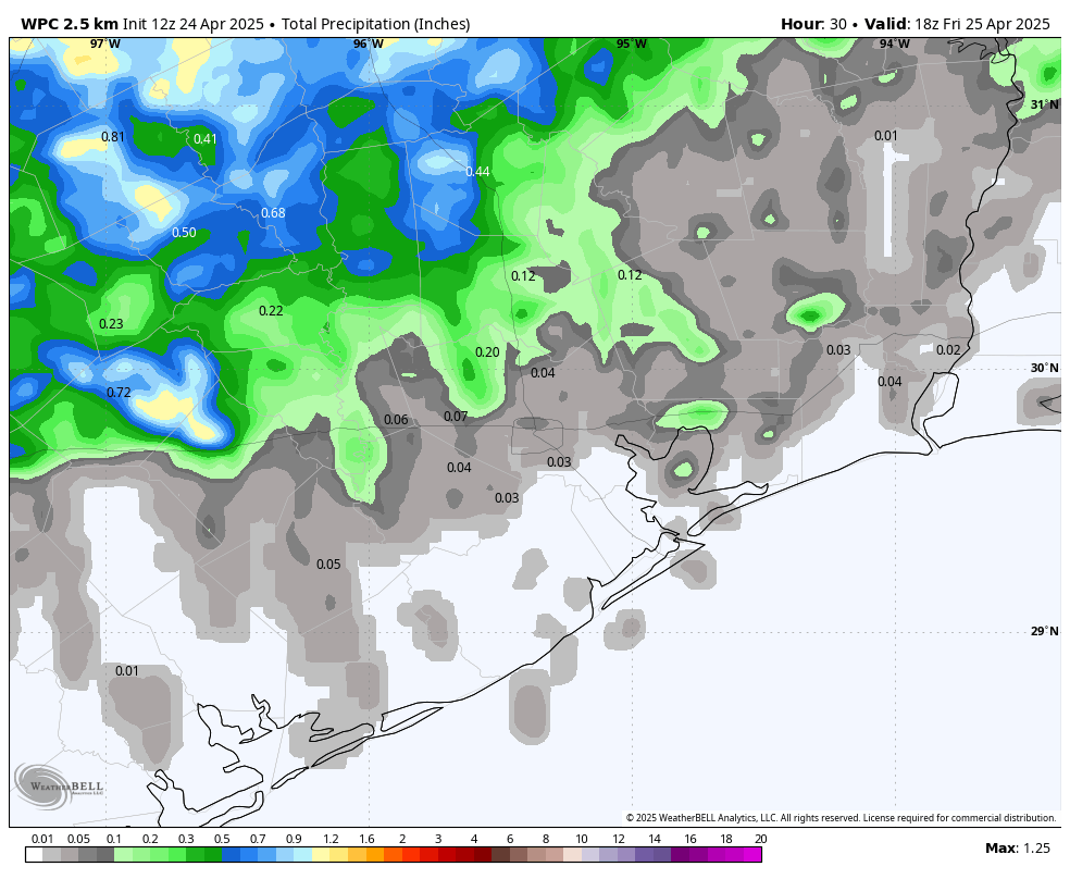
Most parts of the Houston area have seen a pretty good week in the rainfall department. Everyone has seen about a half inch to an inch of rain, with a couple exceptions near Wharton, College Station, and the East End of Galveston onto the Bolivar Peninsula.

Locations that saw at least 2.5 inches of rain this week. (NOAA)

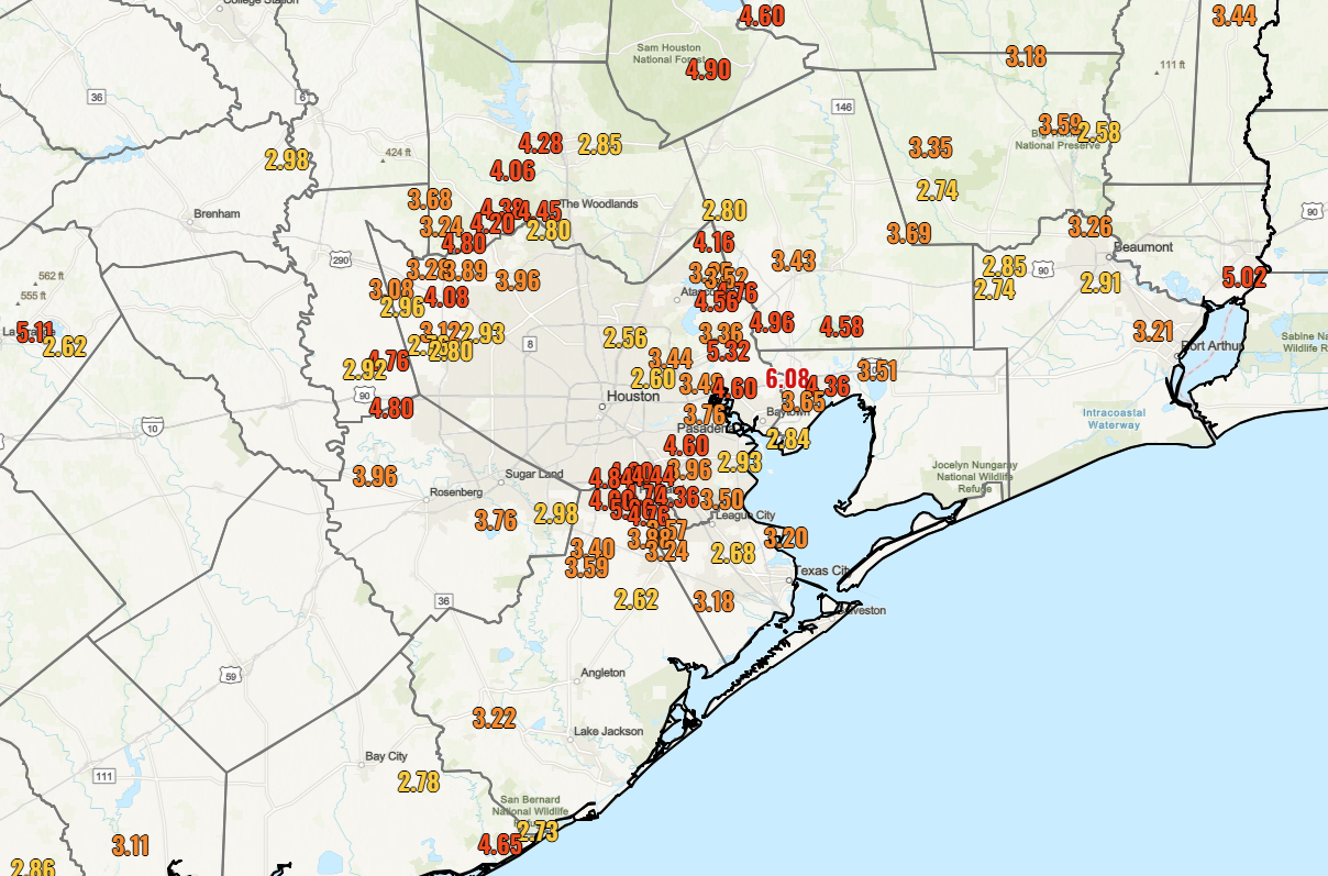
Three areas really stood out this week. The area just north of Baytown and west of Mont Belvieu saw over 6 inches of rain. Pearland also got close to 6 inches of rainfall in spots. It’s likely that Liverpool in Brazoria County may have seen even higher totals this week. The area just south of Lake Livingston also saw nearly 6 inches of rain. So, your mileage definitely varies, but all in all a beneficial week of rainfall here.

Today

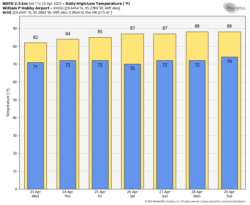
We have one “kinda sorta” chance of rain today. This should not be anything organized; just heating of the day random pop-up downpours. Most places will probably be dry today, but those that see a downpour could snag a quick quarter to half inch of additional rainfall or even a bit more along with some thunder and lightning. Otherwise, expect decreasing clouds and highs well into the 80s. All good for the Dash match tonight.

Saturday and Sunday

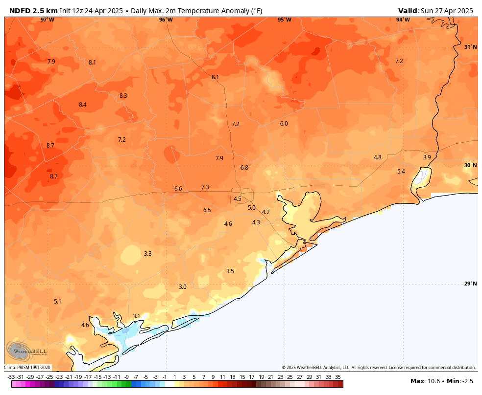
Both days may start off with clouds but transition to sunshine. Expect warm, humid conditions all weekend. Highs will be in the mid to upper-80s, with lows around 70 degrees. MS150 riders will get the tailwind this weekend at least, out of the southeast 5 to 15 mph or so. An isolated downpour can’t be entirely ruled out for the weekend, especially on Sunday, but it seems highly unlikely. Conditions look all good for the SaberCats or Dynamo matches Saturday.

Monday and Tuesday

I would expect more of the same for the start of next week: Clouds to sun, highs in the upper-80s and lows in the low to mid-70s. We do have a chance at 90 degrees on Tuesday.

Surface map forecast for next Friday morning showing a chance that a cold front pushes through Houston. We’ll see if that actually occurs. (NOAA)

Wednesday and onward

Conditions get more unsettled Wednesday and Thursday with scattered showers and thunderstorms possible. We’ll see about risks for heavy rain or any severe weather; it’s too soon to say at the moment, but it would seem we will get a couple rounds of storms in the area. We could see a push of drier air follow a cool front on Thursday, which could set up a nice end of the week. Fingers crossed.

A few lingering storms are possible before Houston sails into a calmer and warmer pattern into next week

In brief: After several days of much needed rain, Houston has one more shot at some scattered showers today before the pattern dries up for a while. The weekend, as expected, looks sunny and warm with few concerns beyond humidity.

Thursday

The radar is quiet this morning, but overall the atmosphere above the Houston region remains unsettled. Accordingly, later this morning as temperatures warm up we should see the development of some scattered thunderstorms. A few of these may be briefly heavy, but I certainly expect them to be less disruptive than storms on Wednesday when a few locations recorded in excess of 3 inches of rainfall. Overall rain chances today are probably about 40 percent for areas north of Interstate 10, and 20 percent for areas closer to the coast. Skies this afternoon should become partly sunny, allowing most locations to record high temperatures in the mid-80s. Winds will come from the southeast at about 10 to 15 mph. Lows tonight will only fall into the low 70s.

NOAA rain accumulation forecast for now through Thursday night. (Weather Bell)

Friday

High pressure will begin to build by Friday, and this should lower rain chances to isolated showers, or about 10 percent area-wide. Otherwise skies will be partly sunny with highs in the mid- to upper-80s for most locations. Nights will remain rather warm through the weekend, into next week.

Saturday and Sunday

There are a ton of outdoor activities planned for this weekend, from sitting on the beach to an IRONMAN competition to festivals to long bike rides. The good news is that we’re highly confident in the forecast due to high pressure. Saturday will be partly sunny, and Sunday should be mostly sunny, with both days producing daytime temperatures in the mid- to upper-80s. It’s going to feel fairly humid outside, but it won’t be nearly so humid as we are going to get latter this summer. Both days will see modest winds from the southeast at 10 to 15 mph, with perhaps some slightly higher gusts. With all the sunshine and higher sun angle, please don’t forget the sunscreen for extended outdoor activities.

High temperatures this weekend will be 4 to 8 degrees above normal for late April. (Weather Bell)

Next week

Monday through Wednesday will see continued warm and humid weather, with highs remaining in the mid- to upper-80s. However days will bring partly to mostly cloudy skies instead of full sunshine. By Wednesday or so a weak front will approach and possibly move into the area. This will start to increase rain chances on Wednesday, Thursday, and Friday. It may also eventually bring some slightly drier and cooler air by next weekend, but we’ll have to wait and see about that.

The bottom line is that the remainder of April is going to be rather warm, just like the rest of the month, which has been about 5 degrees above normal. Whether this is a harbinger for summer it is difficult to say. Let us hope not.

A robust line of storms will move through Houston today, with heavy rain likely

In brief: Showers and thunderstorms will spread into the greater Houston area this morning, and because this is a fairly large system there is the potential for some modest street flooding. A Stage 1 flood alert is in place through the mid-afternoon hours as a result. The weekend still looks sunny and warm as high pressure moves in.

Unsettled environment

After calmer weather on Tuesday, an unsettled pattern returns today. A fairly robust line of storms lies to the west of Houston, and it is trundling toward the metro area this morning. Although there is a modest capping inversion over the greater Houston area, it probably will break as these storms near by mid-morning. Because our soils are already somewhat sodden after rains on Sunday and Monday, these additional rains could lead to some street flooding due to runoff. For this reason we are putting a Stage 1 flood alert into place through mid-afternoon today.

Wednesday

The storms west of Houston should push into Houston between around 9 am and 3 pm CT, with the greater likelihood of heavy rain south of Interstate 10. Although some damaging winds are possible, the overall severe threat is low, and our primary concern is heavy rainfall that may cause some street flooding. Most areas will probably see manageable totals of 0.5 to 2.0 inches, but there could be some higher bullseyes of 3 or more inches before the storms shift eastward this afternoon. I expect road conditions to be fine for the evening commute home.

With mostly cloudy skies amid the rain, high temperatures today will likely peak around 80 degrees, or a bit higher, for most of the area. Winds will be from the southeast at about 10 mph, although we could see some higher gusts along with some of the stronger thunderstorms. A few isolated showers will be possible this evening, with lows tonight dropping into the low 70s in the Houston area.

Thursday and Friday

Plenty of moisture remains in the atmosphere on Thursday and Friday to support additional showers and thunderstorms, however we will be lacking a spark. Therefore my best guess is that, overall, rain chances will be quite low, on the order of 20 percent. But if we do see some showers they could be briefly heavy. For the most part I expect these to be partly sunny days, with temperatures in the mid-80s and southerly winds in the vicinity of 15 mph. Nights remain warm, with lows falling to around 70 degrees.

The end of April will see rather warm conditions. (Weather Bell)

Saturday and Sunday

As anticipated, this weekend should bring mostly sunny skies and an end to rain chances as high pressure builds over the area. Expect high temperatures in the vicinity of the mid-80 to upper-80s both days with warm nights. Winds will come from the southeast at about 15 mph, which will be a boon for MS-150 riders. Alas, dewpoints of around 70 degrees will make it difficult for participants in the IRONMAN event in The Woodlands.

Next week

This pattern more or less continues into the middle of next week until the high pressure shoves off, and we are left with the potential for more unsettled weather. A front will approach the area, and this should generate some healthy rain chances. Whether it pushes all the way to the coast and brings us some drier and cooler air is something we’re just going to have to wait and see.

Additional shower and thunderstorm chances today and Wednesday before warmer and sunnier weather

In brief: After Houston picked up some needed rainfall over the last two days, we will continue to see shower chances for a few more days. By this weekend we should be sunny and fairly humid. Although it won’t feel quite summer-like, it still will be rather warm for late April.

Much-needed rainfall

After a fairly dry spring so far, nearly the entire Houston metro area picked up at least 1 to 2 inches of rain over the last two days. Some areas received as much as 5 inches. I will make two predictions as a result of this. First, by this weekend, your lawns will start to take on the appearance of a jungle with the combination of rain and sunny skies helping everything to green up and grow rapidly. And secondly, I fear that we’re going to see an outpouring of mosquitoes for the first time this spring. So goes the circle of life in Houston.

In Houston, this is the real circle of life. (CDC.gov)

Tuesday

With that said, we are not yet done with rain. Overall chances are fairly low today, probably 20 to 30 percent area-wide, although perhaps a bit higher near the coast. Once this morning’s patchy fog gives way, we should see partly sunny skies with high temperatures in the mid-80s. With dewpoints around 70 degrees it will feel fairly sticky outside. Winds will be fairly light, from the south at about 10 mph. If showers do develop, they are most likely during the afternoon or early evening hours. Lows tonight will only fall to around 70 degrees.

Wednesday

A passing disturbance will raise the chance for showers and thunderstorms to at least 50 percent on Wednesday. A couple of readers have asked about timing, but I don’t have a real clear picture. There could be showers at sunrise and near sunset, but at this time the most widespread and organized activity is likely to occur during the afternoon hours with peak heating. Some rain could be briefly heavy, but I don’t expect any severe thunderstorms. With mostly cloudy skies, temperatures should peak in the low 80s. Expect another warm night.

NOAA rain accumulation forecast for now through Wednesday. (Weather Bell)

Thursday and Friday

These should be partly sunny and warmer days, with highs in the mid-80s in Houston, and possibly a bit warmer for areas further inland. Both days will have a slight chance of some thunderstorms and rain. Right now I’ll peg those chances at 20 percent, but there remains some uncertainty in the overall pattern.

Saturday and Sunday

The weekend looks warm and mostly sunny, with high temperatures in the mid- to upper-80s and plenty of humidity. Expect modest southeasterly winds of about 15 mph, with higher gusts, on both days, so that will help MS-150 bike riders with a tailwind at times, and a cross-tailwind at other times. It’s about the best you could hope for for a long weekend ride. Unfortunately for IRONMAN participants, dewpoints in the vicinity of 70 degrees will make for a very sticky race. Personally, I find it very difficult to run in such conditions and cannot imagine running a marathon in that kind of humidity. Good luck to all.

Expect warm nights for awhile. (Weather Bell)

Next week

Much of next week looks partly cloudy, humid, and warm with temperatures in the upper 80s. It still appears as though some kind of pattern change is in the cards for later next week, with the return of some rain showers and possibly some cooler and drier air. It’s far too distant to have any confidence in the details, however.